
In this post, I will be taking a close look at the area around Harpers Ferry, West Virginia, from the perspective of its considerable infrastructure and history.
I will demonstrate as I go through here that a case can be made that all of this infrastructure has connections to an original energy grid that we have not been told about, and in fact, there are still energy-related facilities through here to this day.
Harpers Ferry is also a unique location to study in that along with its hydroelectric energy infrastructure, it figured prominently in the Civil War-era, with historical events and battles taking place in -and-around Harpers Ferry.
I have long-believed that while something happened during the Civil War years, it was not about what we have been taught from cradle-to-grave, and suspect it had more to do with covering up the Old World Civilization, its original infrastructure, and its people, and I will show you why I believe this to be the case in this study.

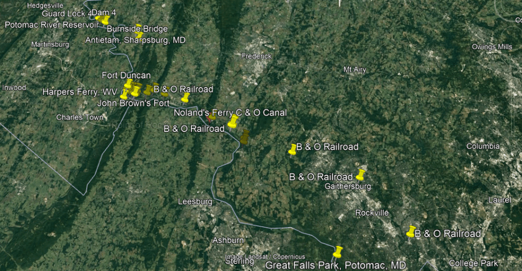
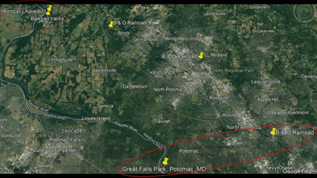
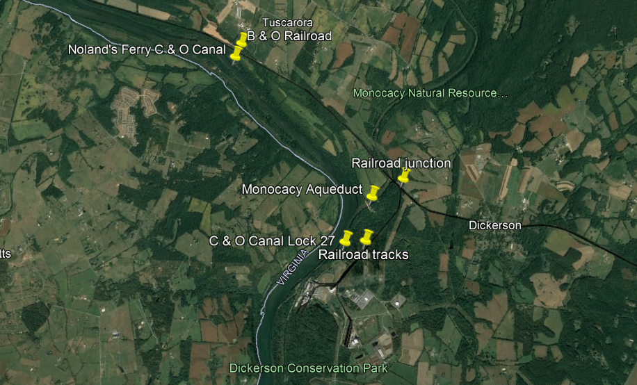
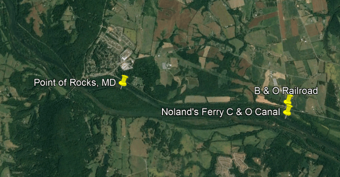
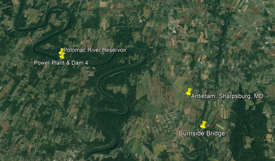
Here is a Google Earth Screenshot along the Potomac River between Great Falls Park in Potomac, Maryland, showing all the infrastructure that is found along here in-between there and the Potomac River Reservoir north going through Harper’s Ferry, including the C & O Canal, the B & O Railroad, bridges, aqueducts, reservoirs, forts and batteries.
Harper’s Ferry was an infamous location during the American Civil War, and so was the Battle of Antietam in Sharpsburg, Maryland, one of its bloodiest battles.
I grew up near here in Montgomery County, Maryland, and I have been to a number of these places multiple times, particularly Harper’s Ferry and Antietam.
First, a few things about the Baltimore & Ohio (B & O) Railroad and Chesapeake & Ohio (C & O) Canal.
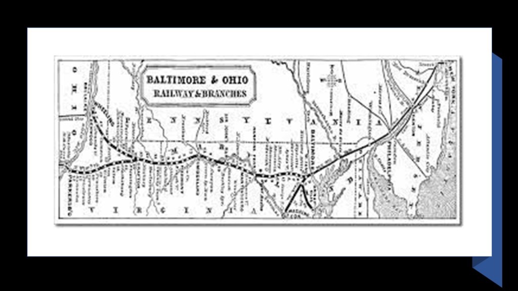
In 1827, the State of Maryland chartered the Baltimore and Ohio (B & O) Railroad, the first common carrier, and the oldest, railroad in the United States.
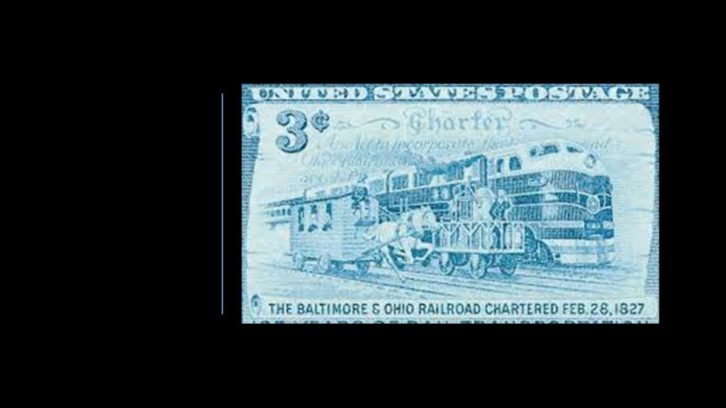
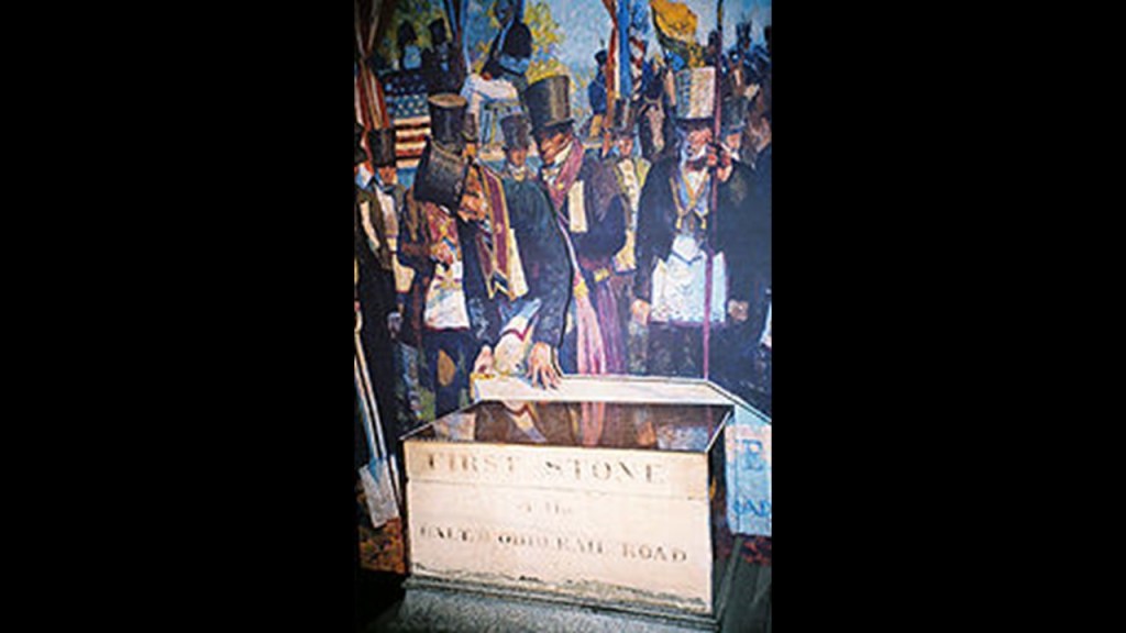
The Baltimore & Ohio Railroad Company was formed in 1827, of which U. S. Founding Father & Declaration of Independence Signer Charles Carroll of Carrollton was one of its Directors, and he was the one that had the honor of laying the first stone for the railroad at the ceremony after the celebratory festivities at the July 4th ground-breaking in 1828, near his Mount Clare Mansion.
We are told there was an intense rivalry between the B & O Railroad, and the Chesapeake & Ohio (C & O) Canal, with each project choosing the same day of July 4th of 1828 to break-ground.
The Mount Clare Shop was the oldest railroad manufacturing complex in the United States, located on a portion of the Carroll family’s Mount Clare Mansion, and the mansion left the family’s ownership in 1840.
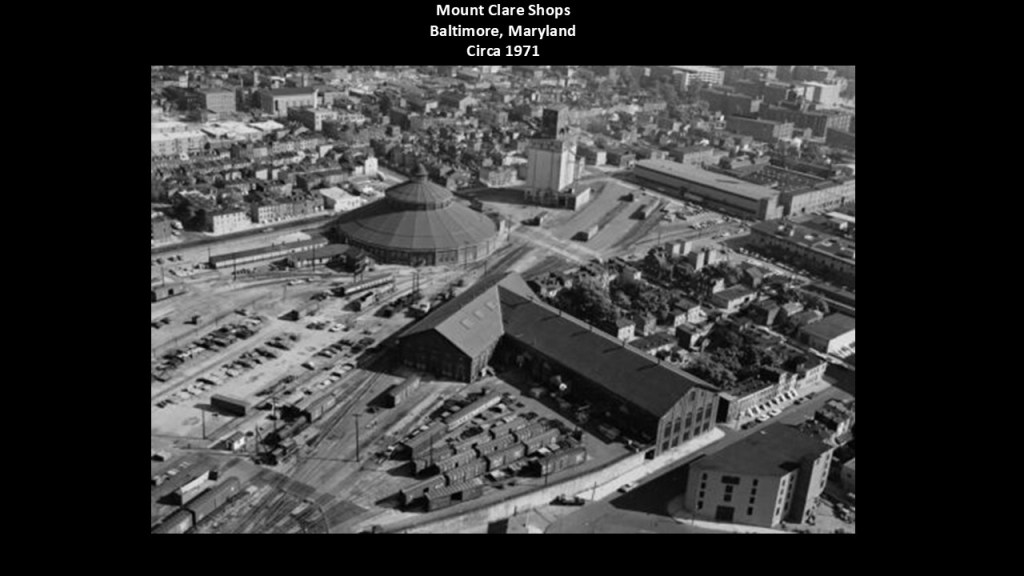
Mount Clare Station was first said to have been constructed starting in the 1830s.
We are told the original Mount Clare passenger station, the first in the nation, was abandoned, and was located where the parking lot is for the museum is today.
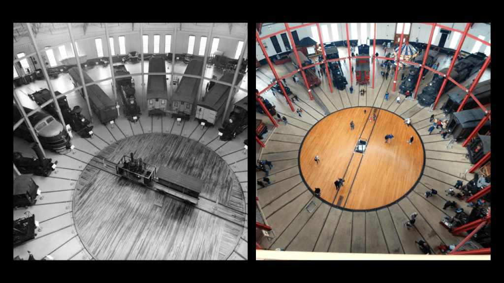
The B & O Railroad Museum is housed in the intact roundhouse, one of the very few such railroad buildings to remain in existence.
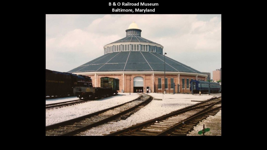
The existence and true purpose of these railroad roundhouses have been removed from history, with very few exceptions.
The first section of the B & O Railroad was said to have opened in 1830, said to have reached the Ohio River in 1852, the first eastern seaboard railroad to do so.
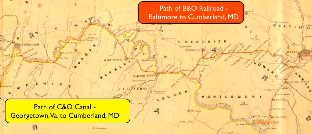
We are told both projects were vying for the narrow right-of-way where the Potomac River cuts through a mountain ridge not far from Point of Rocks, Maryland, which ended up in court.
Even though after four-years the case was said to have been ruled in favor of the canal, we are told the C & O Canal had to allow the B & O Railroad to go through there, so this is a place where the canal and the railroad run side-by-side, and that within a few years the canal was made obsolete because the railroad was so much more efficient.

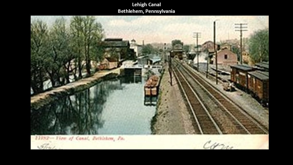
And this incredible engineering feat of canals and railroads running side-by-side is found in countless other places, with examples like the Lehigh Canal in Bethlehem, Pennsylvania…
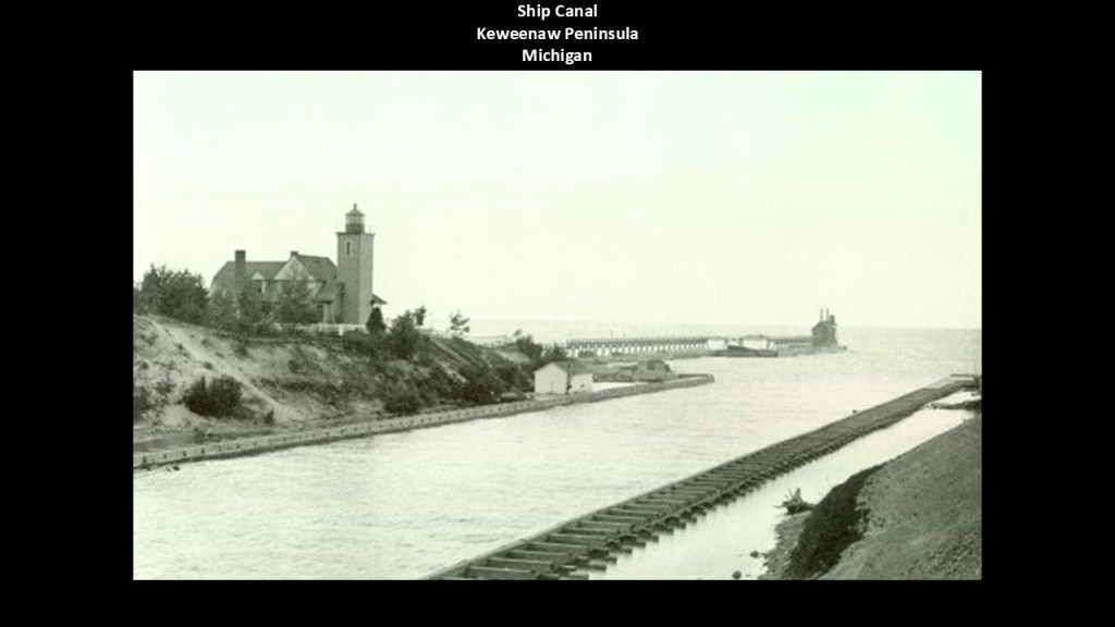
…and this one of the Ship Canal on Michigan’s Keweenaw Peninsula.
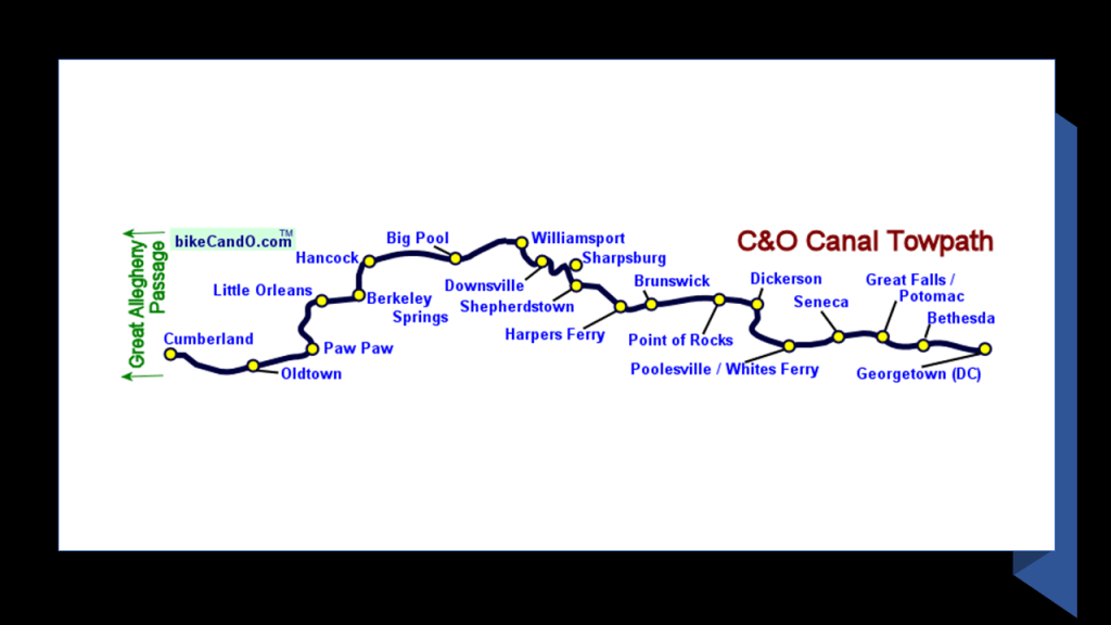
For the purposes of this study, I am going to be taking a close look at a series of Google Earth screenshots of sections of the Potomac River between Great Falls Park in Maryland and the Potomac River Reservoir just to the west of Sharpsburg, Maryland, where the Battle of Antietam took place.
This first section in Montgomery County was in my stomping grounds growing up.
The first two pins down at the bottom of the screen show the relationship and distance at the locations between the Potomac River, Great Falls and the C & O canal, and where the B & O Railroad today makes its way through Montgomery county.
Now I want to bring your attention to what is at the top left of the screenshot at the pins of “Monocacy Aqueduct” and “Railroad tracks.”
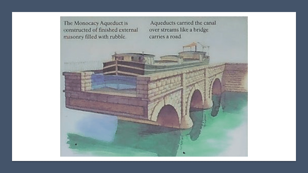
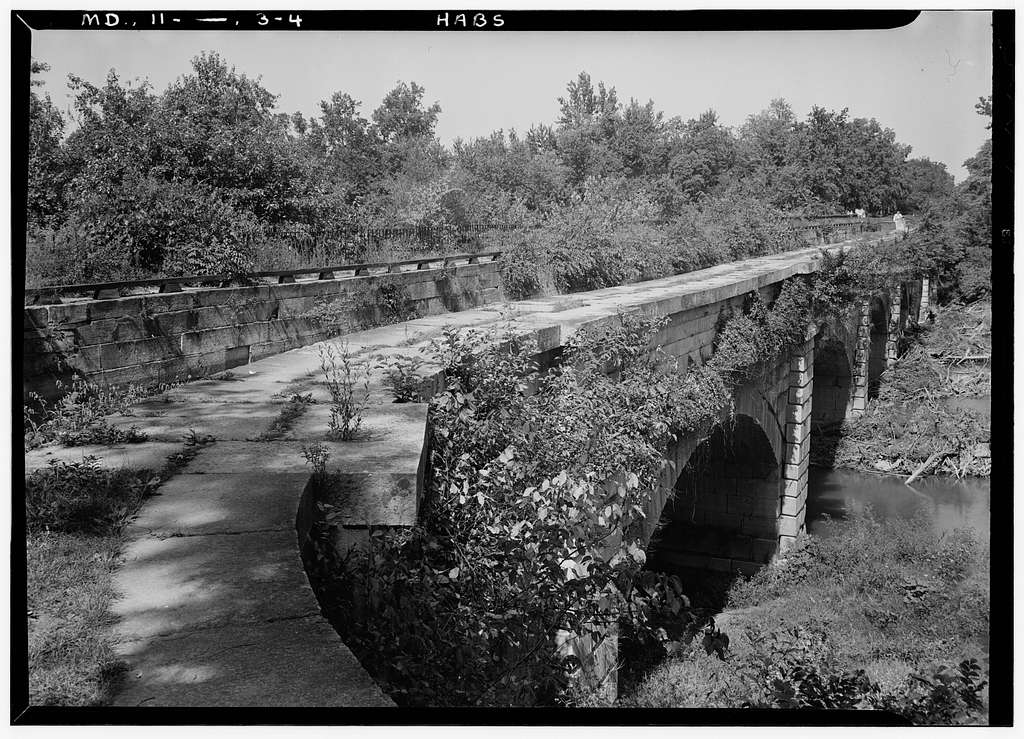
The Monocacy Aqueduct was said to have been built by three different contractors between 1829 and 1833.
It is the largest aqueduct of the eleven aqueducts on the C & O Canal, crossing over the Monocacy River before it meets the Potomac River.
It is described by many historians as one of the finest canal features in the United States.
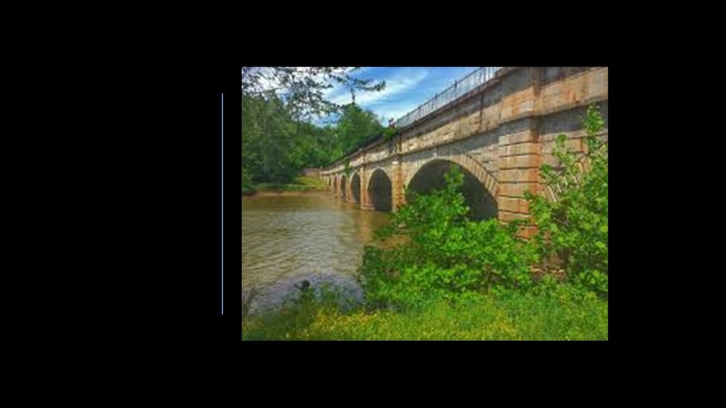
This solid, stone-masonry structure has a waterway of 19-feet, or 5.8-meters at the bottom, and 20-feet, or 6.1-meters at the top.
It was used as part of the canal system for canal boat transportation, and said to have been utilized by the Union Army during the Civil War to transport war materials and troops between Maryland, Virginia, and places west.
The story goes that the Confederate Army had plans to blow up the aqueduct but were unsuccessful in doing so for a variety of reasons, from being talked out of it by the keeper of Lock 27, to not being able to drill enough holes to insert the amount of dynamite necessary to blow it up.
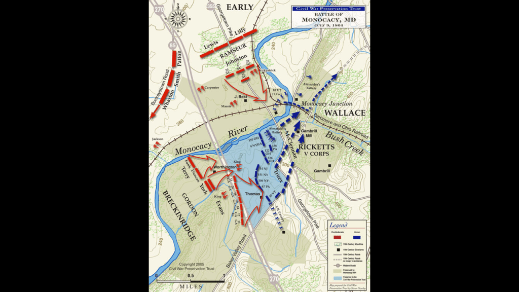
Another is that the Battle of Monocacy took place not far from here in Frederick County in July of 1864, and came about because Union troops were there to protect a railroad bridge at Monocacy Junction, Maryland, where it crossed the Monocacy River, as Confederate troops marched towards Washington.
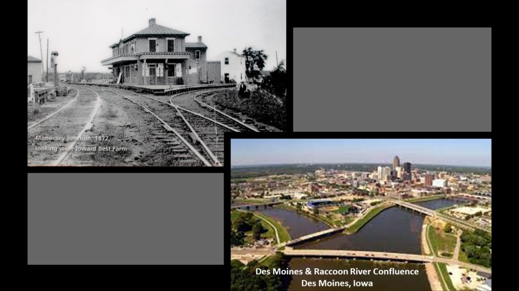
On the top left is a photo of the Monocacy Railroad Junction circa 1872, and on the bottom right is a photo of the confluence of the Des Moines and Raccoon Rivers in Des Moines, Iowa, one of countless examples of so-called river confluences that look exactly like the Monocacy Junction, and were actually canals.
A junction is defined as a “an act of joining or adjoining things,” implying intentionality as opposed to something that just happens randomly.
An electrical junction is defined as a point or area where multiple conductors or semi-conductors make physical contact.

The next point of information here that is noteworthy is that there is another railroad junction near the Monocacy Aqueduct itself, where another rail-line branches off from the main B & O rail-line that runs closer to the Potomac River and C & O Canal here.
Also here the C & O Canal is hard to distinguish from the Potomac River through here.
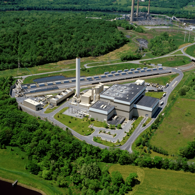
The short Dickerson spur-line ends at the facilities for the Dickerson Plant and Covanta Montgomery.
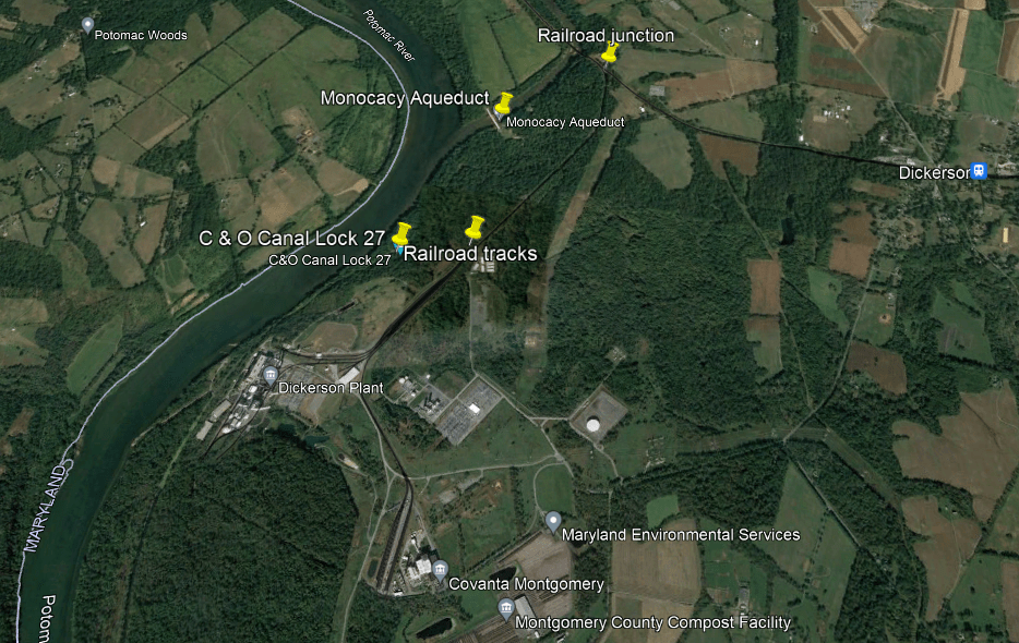
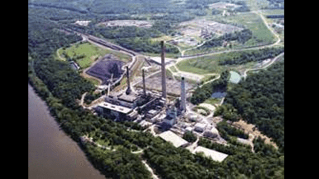
The Dickerson Plant refers to the Dickerson Generating Station, an 853-megawatt electric-generating plant owned by NRG Energy.
It has a history of toxic metal releases into the Potomac River, like arsenic and mercury.
It is located next to the C & O National Historical Park, with C& O Canal Lock 27 being nearby.
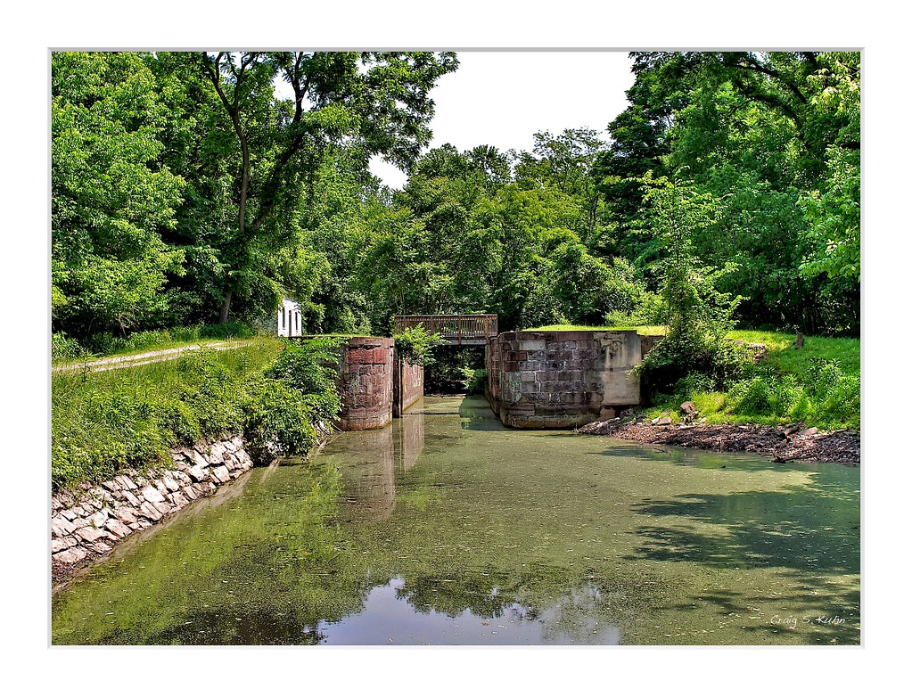
Canal Locks are used to raise and lower boats between stretches of water of different levels.
The C & O Canal has 74 locks altogether along its 184.5-mile, or 297-kilometer, length.
The other plant here in Dickerson is Covanta Montgomery, the Montgomery County Resource Recovery Facility, which is a 56-megawatt incineration plant that burns municipal garbage and waste and turns it into energy.
It is served by the CSX railroad line, which brings trash from Montgomery County Central Transfer and Recycling facility in Derwood, Maryland.
In the next section, from the Monocacy Aqueduct to the train station at Point of Rocks, Maryland, the railroad tracks start to run closer to the C & O Canal and the Potomac River, and then run side-by-side.
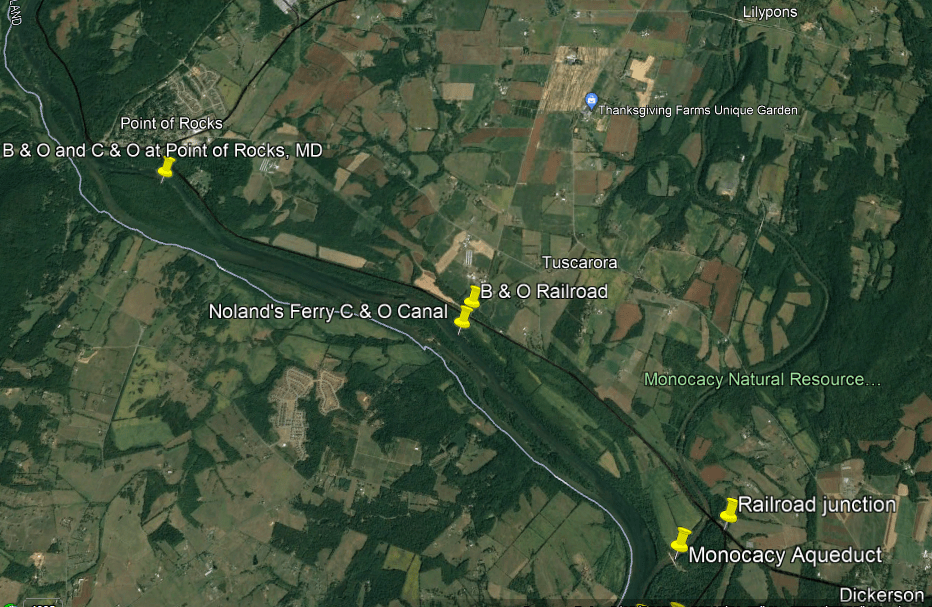
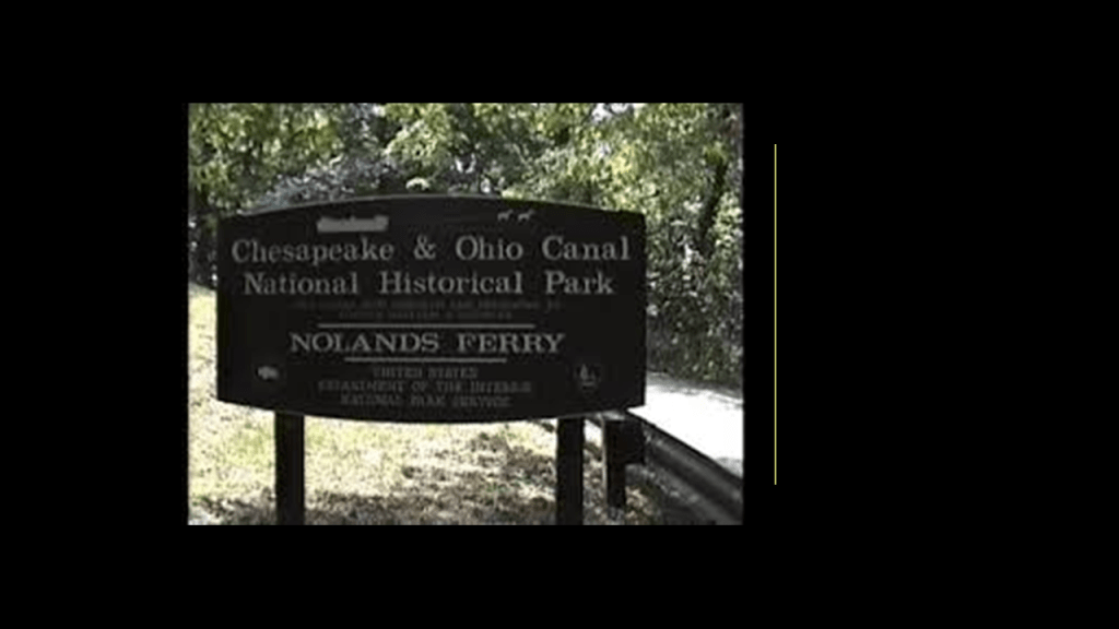
Starting at Noland’s Ferry, the railroad, C & O Canal, and the Potomac River start to run together right next to each other for a long-distance.
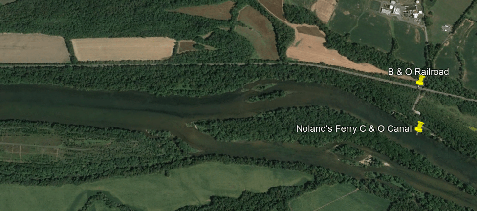
Noland’s Ferry started running in the middle of the 1700s, carrying travellers between Loudon County, Virginia, and Frederick County, Maryland.
It was said to have been used for crossing the Potomac River in both the Revolutionary War and Civil War.
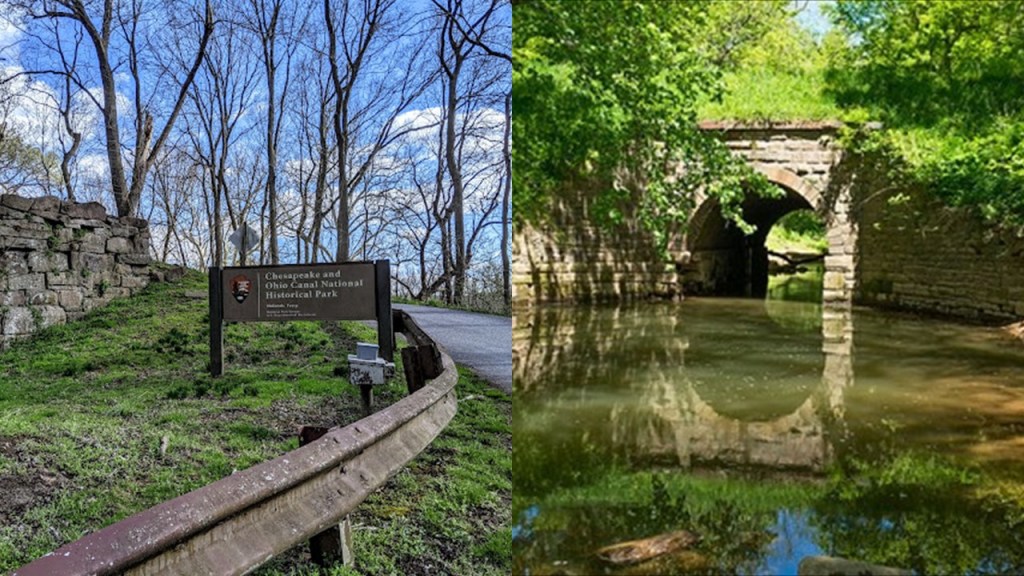
This is a stone structure at the entrance to Noland’s Ferry Park on the left, and Culvert 71 on the right is located in the park at mile marker 44.04 just before you get to the historical location of Noland’s Ferry at mile marker 44.6
Both structures appear to be very old.
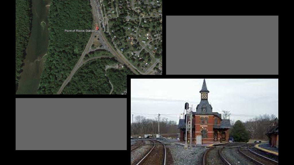
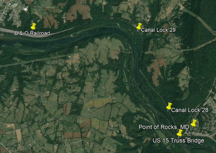
Next we come to Point-of-Rocks, Maryland.
So, let’s take a closer look at Point of Rocks.
We are told Point of Rocks was the western terminus of the B & O Railroad from 1828 to 1832, while the B & O and C & O awaited the court decision on the hotly-contested right-of-way through here mentioned previously.
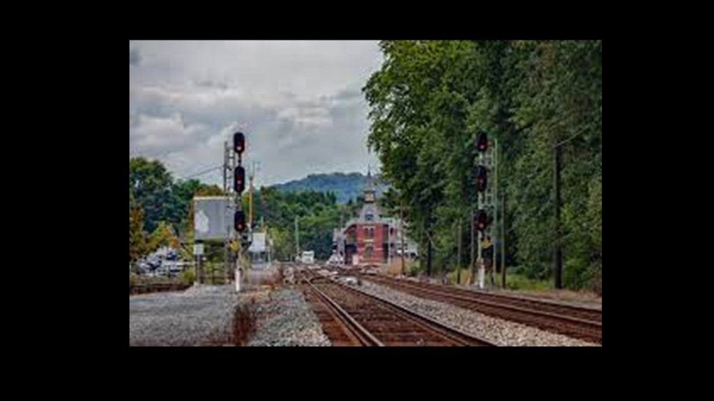
The train station here was said to have been built in Gothic Revival-style in 1873 by the B & O Railroad at the junction of the B & O Main-line running to Baltimore and the Metropolitan Branch running to Washington, DC, which had opened for passenger service in 1873.
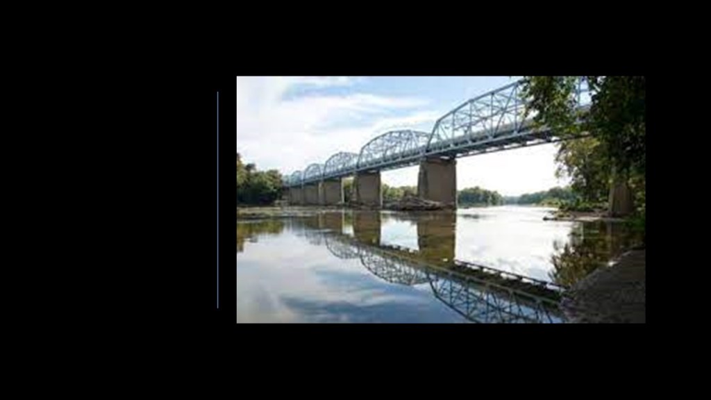
The parking area for the C & O Canal National Historic Park is just south of the U. S. Highway 15 Truss Bridge at Point of Rocks next to the Potomac River.
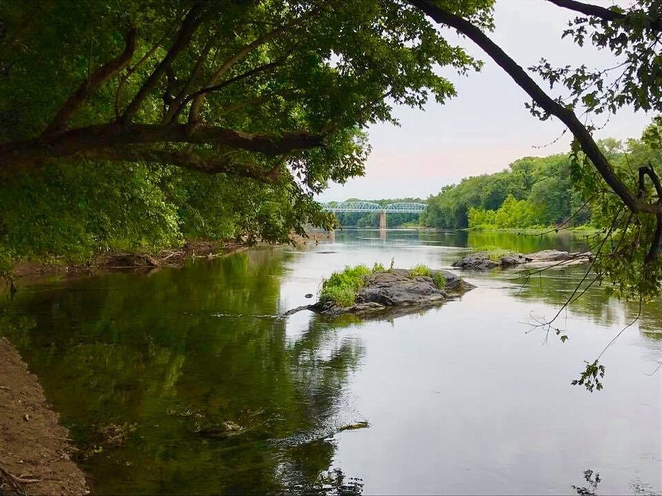
The two-lane, eight-span Camelback Truss Bridge at this location connects Maryland and Virginia, and was said to have been built in 1937, which would have been during the Great Depression.
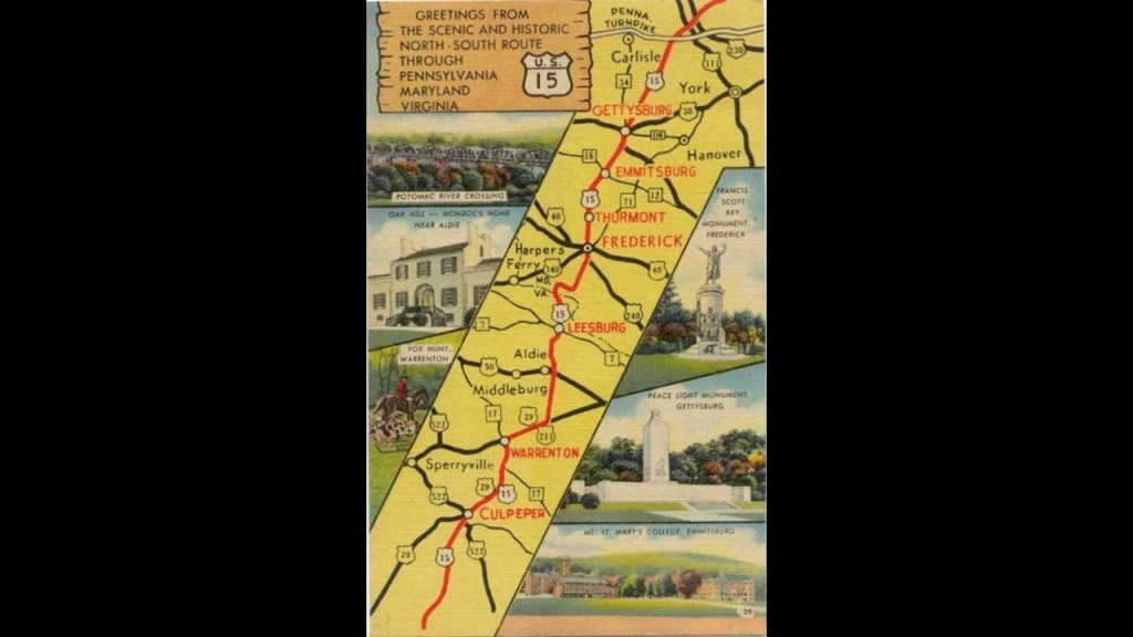
U. S. Highway 15 is a United States Numbered Highway that serves New York, Pennsylvania, Maryland, Virginia, North Carolina and South Carolina, and is one of the original numbered highways that was approved in 1926.
It is 792-miles, or 1,274-kilometers, in length.
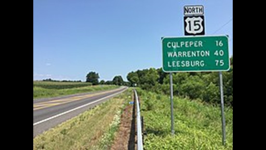
US-15 is known as the “Journey Through Hallowed Ground National Scenic Byway,” as it closely follows the historic corridor used for pivotal Civil War movements and troop engagements, including, but not limited to, the Battle of Gettysburg in 1863.
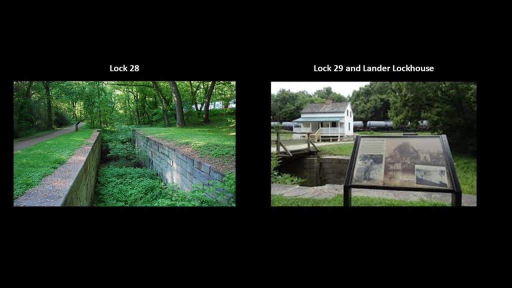
There are two locks on the C & O Canal near Point of Rocks.
Lock 28 is pictured here on the left, and Lock 29 and the Lander Lockhouse on the right.
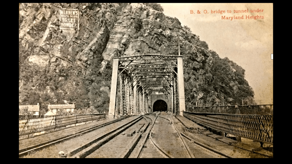
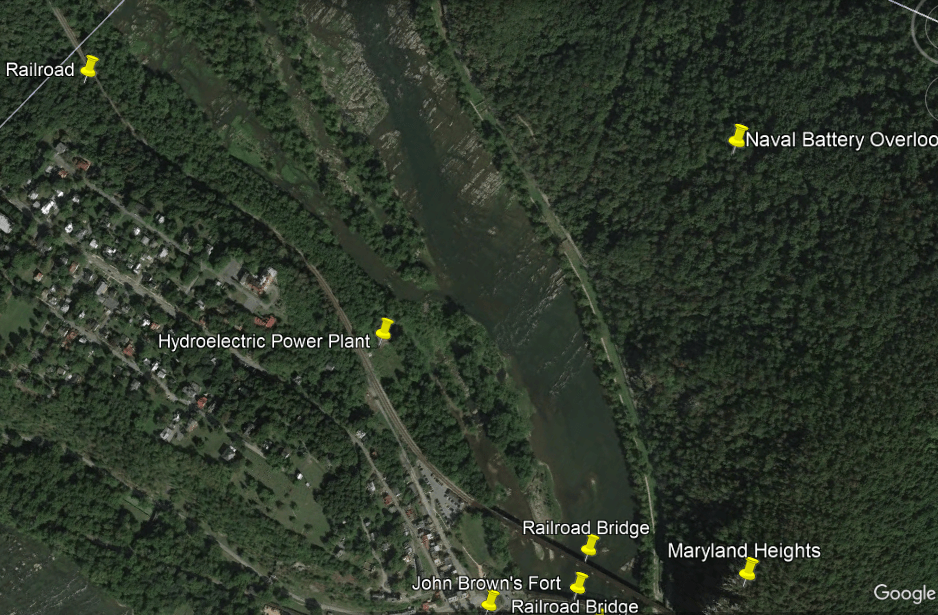
On the railroad’s way from here to Harper’s Ferry, West Virginia, its tracks run through a tunnel at Maryland Heights.
Where the tunnel comes out on the other side, among other things, there is an advertisement for passengers for “Mennen’s Borated Talcum Toilet Powder” high up on the face of Maryland Heights said to date from the early 1900s.
The Maryland Heights Trail connects to the Appalachian Trail, and I remember being at this location of the tunnel as part of a group hike on the Appalachian Trail through this area when I was a teenager.
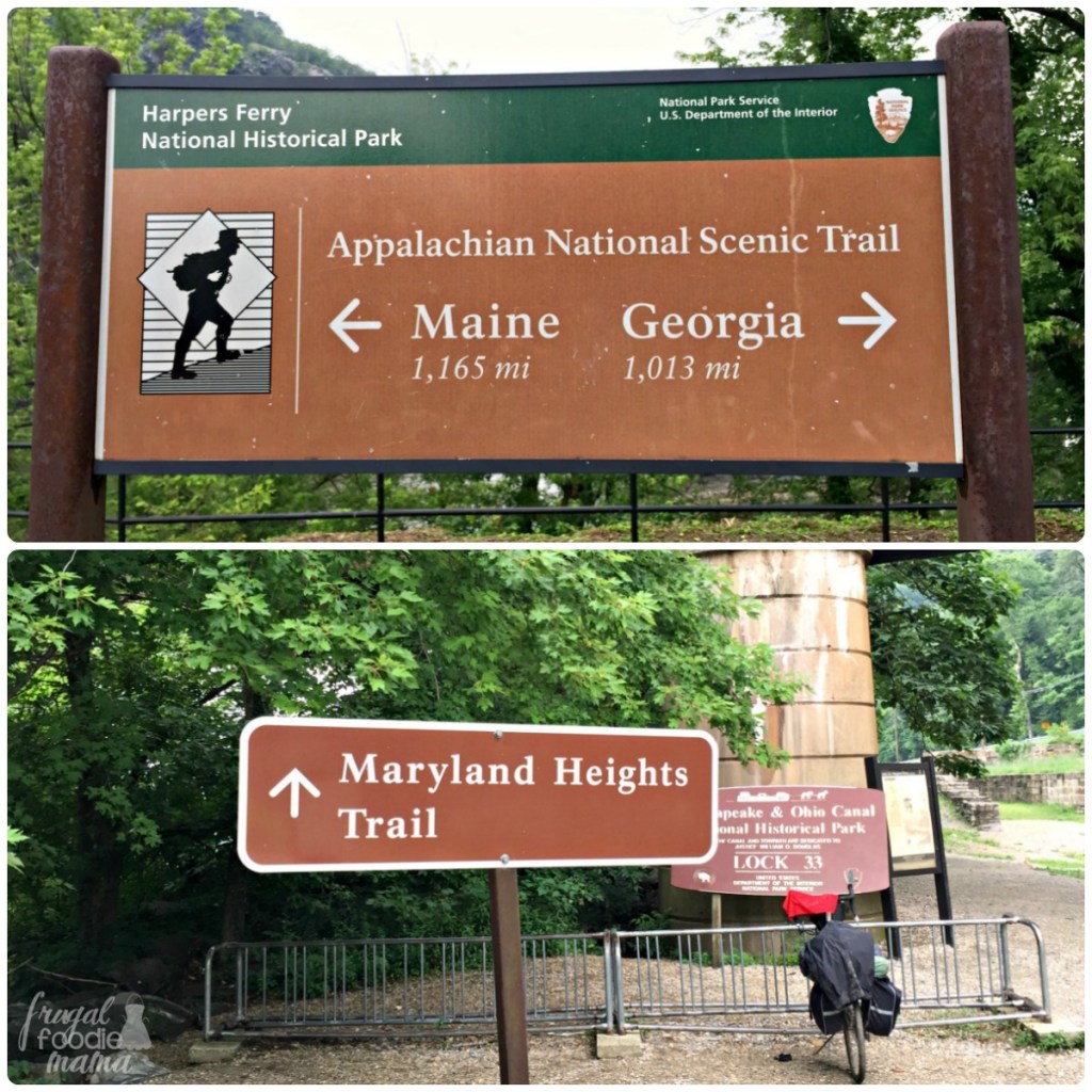
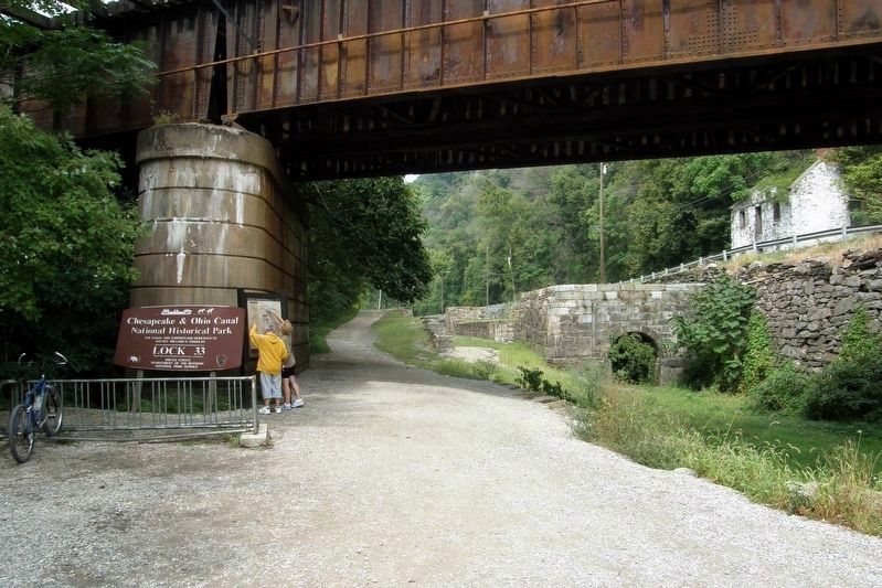
C & O Canal Lock 33 is part of the Maryland Heights Trail.
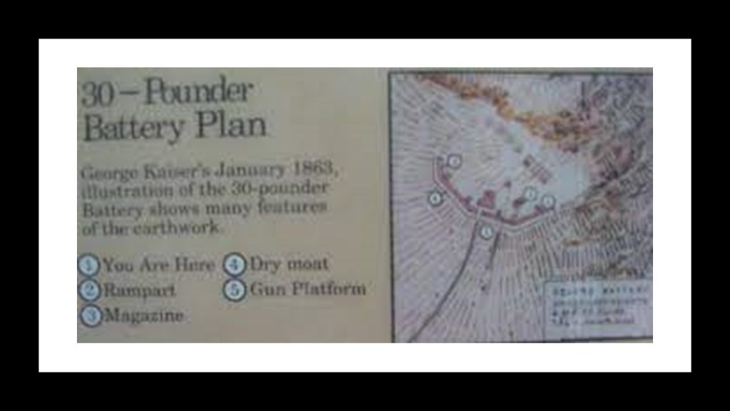
Before crossing over the Railroad bridge here over the Potomac River where the Potomac and Shenandoah Rivers meet, there’s a few places I want to take a look at on this side of the Potomac River here first on Maryland Heights – a 30-pounder battery; a 100-pounder battery; and the Naval Battery Overlook.
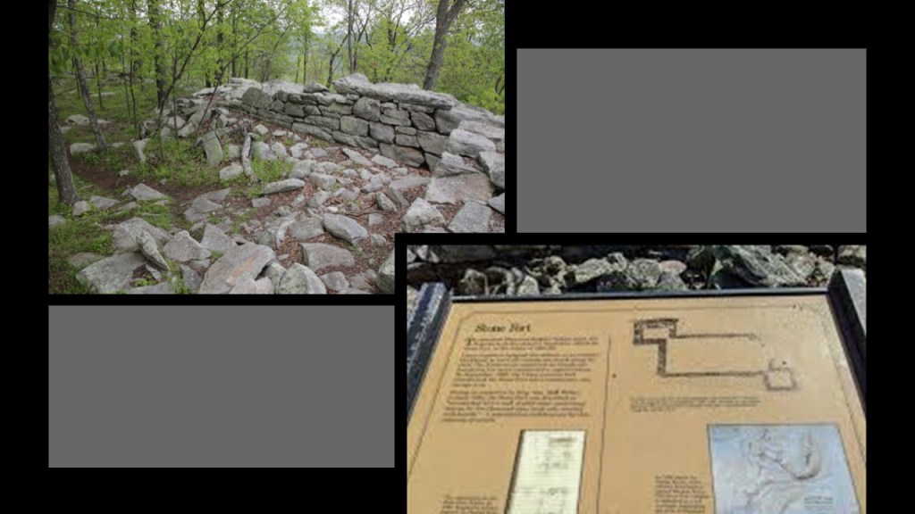
On the Stone Fort Loop Trail of the Maryland Heights Trail, the 30-pounder battery was said to have been the first earthen battery built by the federals in the fall of 1862, at the end of a towering plateau that perfectly commanded the summits of Bolivar and Loudoun Heights facing south.
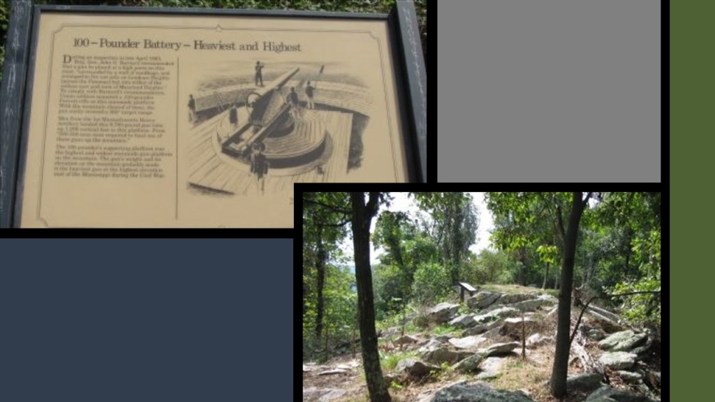
Higher up on Maryland Heights, we come to the 100-pounder battery on the Stone Fort Loop section of the trail.
We are told this battery was recommended by a Union general in the spring of 1863 that could fire a 100-point Parrott rifle 360-degrees in all directions from its lofty location.
The Stone Fort was said to have been built by the Union Army on top of Maryland Heights during the winter of 1862 and 1863 to ward off Confederate attack along the crest.
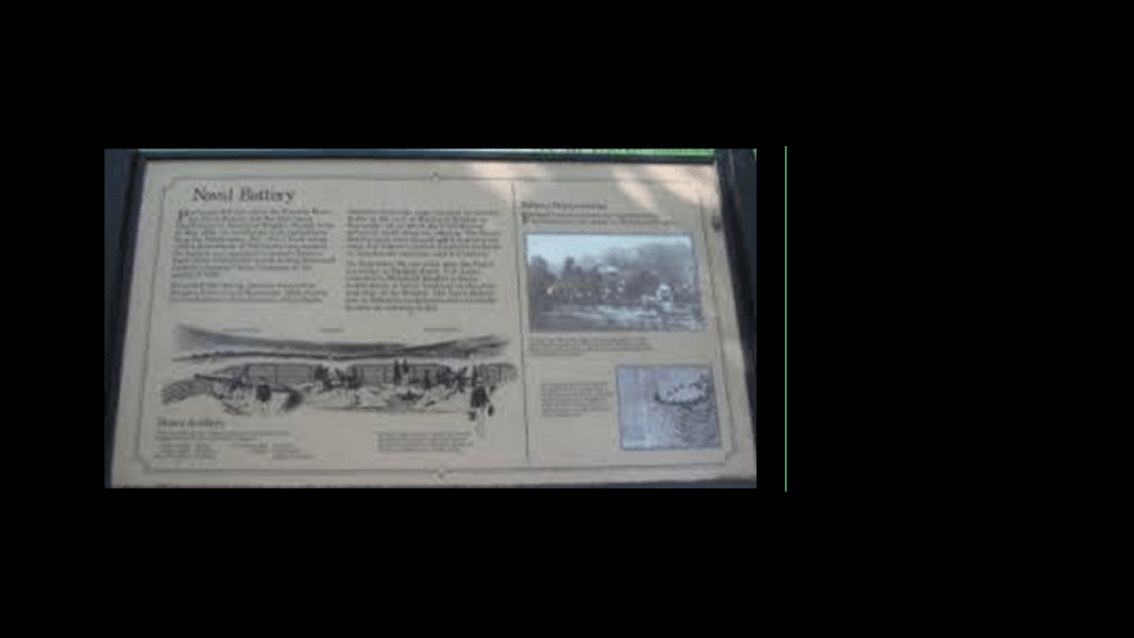
The Naval Battery was said to have been the first Union Fortification on Maryland Heights, and quickly built in May of 1862 to protect Harper’s Ferry from Confederate attack during General Stonewall Jackson’s Shenandoah Valley Campaign in the spring of 1862, and where there was a battle with Jackson’s troops in September of 1862.
The Union forces were said to have been forced to retreat and abandon the Naval Battery until they came back to Maryland Heights to build the better fortications we just saw higher up.
Before I move on into Harper’s Ferry proper, I would like to assert my belief that what has come down to us in our historical narrative as military fortifications, were in fact actually batteries on the original energy grid.
This brings us to meanings of the word “battery.”
One is “a device that produces electricity; may have several primary or secondary cells arranged in parallel or series.”
And another is “the heavy fire of artillery to saturate an area rather than hit a specific target.”
I find these historic forts worldwide, which are often actually called “batteries” and nowadays “star forts,” arranged in pairs or clusters, like these here at this location at Maryland Heights overlooking Harpers Ferry, and that that Civil War narrative, as one of many examples in our narrative, gave the cover story needed to explain how they came into existence and why they needed to be destroyed as military targets.
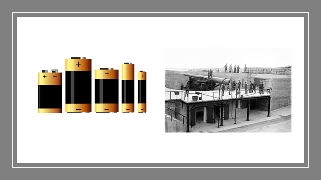
I believe that what came down to us as fortifications and artillery batteries in our narrative originally functioned as batteries for the Earth’s original grid system, in the same way that the batteries we use in our daily lives produce electricity for our various devices.
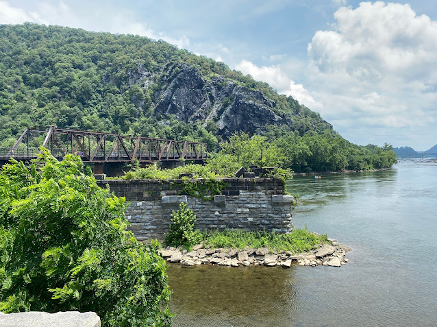
Now getting back to Harpers Ferry, there’s a set of railroad bridges crossing the Potomac River at the confluence of the Potomac and Shenandoah for two different lines.
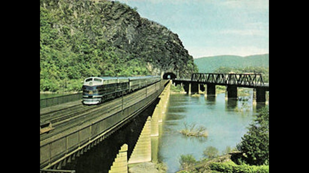
One continues along the Potomac River and the other is a line that runs next to the Shenandoah River.
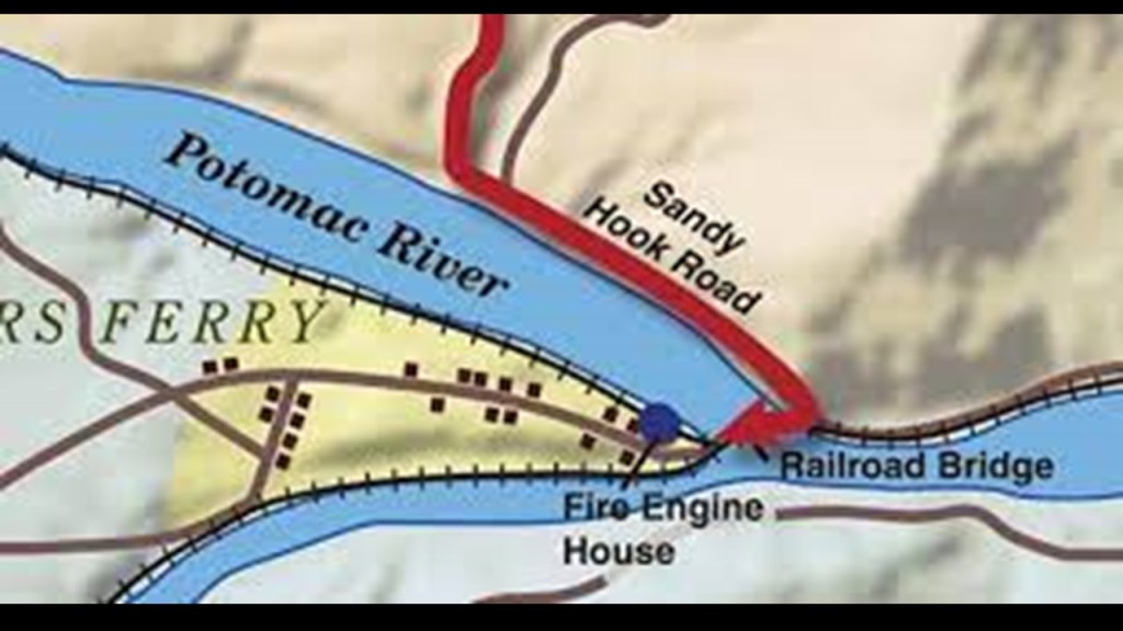
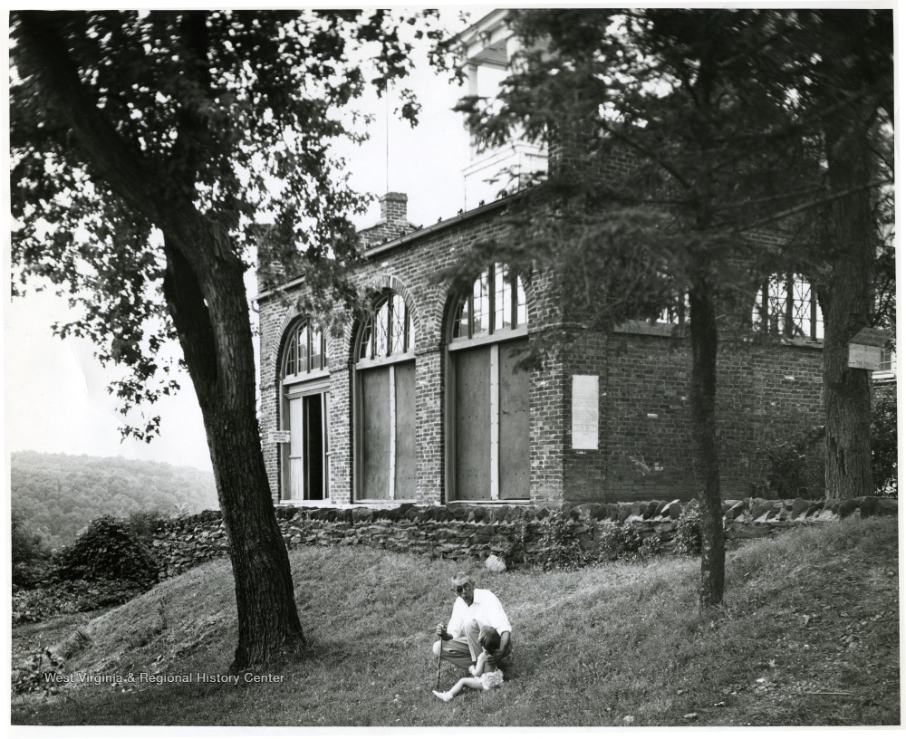
What is known as “John Brown’s Fort” sits at the confluence of the two rivers.
It was said to have been built in 1848 as a guard and fire engine house for the Federal Armory at Harper’s Ferry.
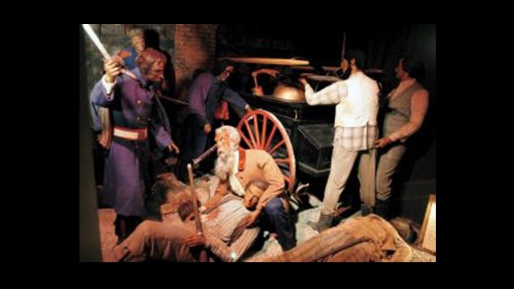
Master Mason John Brown was best known for the Harper’s Ferry raid on October 16th of 1859.

His plan was to raid the Federal Armory and instigate a major slave rebellion in the South, and he had no rations or escape route.
In 36-hours, troops under the command of then Lt. Col. Robert E. Lee had arrested him and his cohorts, who had withdrawn to the engine house after they had been surrounded by local citizens and militia.

While his plan was doomed from the start, we are told John Brown’s Raid served to deepen the divide between the North and South in the years leading up to the Civil War.
John Brown was hung on December 2nd of 1859, less than two months after the onset of the Harper’s Ferry Raid.
Did John Brown take one for the team?
Or did he not see that one coming?


John Brown’s Wax Museum in Harpers Ferry first opened in 1963, and permanently closed in 2024 after the owner sold the building.
The museum depicted the life of John Brown and the Harpers Ferry Raid, and it is my opinion that this museum, and all museums for that matter, are in place to reinforce the official historical narrative in the mind of the public.
Interestingly, we are told that many of the bricks of “John Brown’s Fort” were taken and sold as souvenirs…
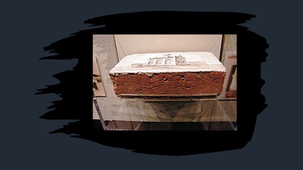
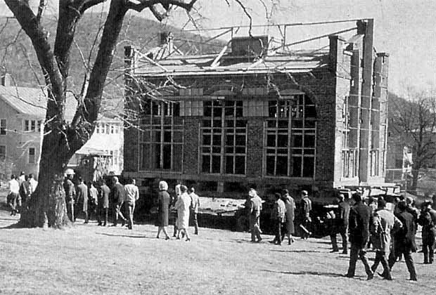
…and that “John Brown’s Fort” was said to have been moved four times.
To Chicago, for an attraction at the 1893 World’s Columbian Exposition; back to Harpers Ferry on the Murphy Farm in 1895; Storers College in Harpers Ferry in 1909; and back to its present, and close to its original location, by the National Park Service in 1968.
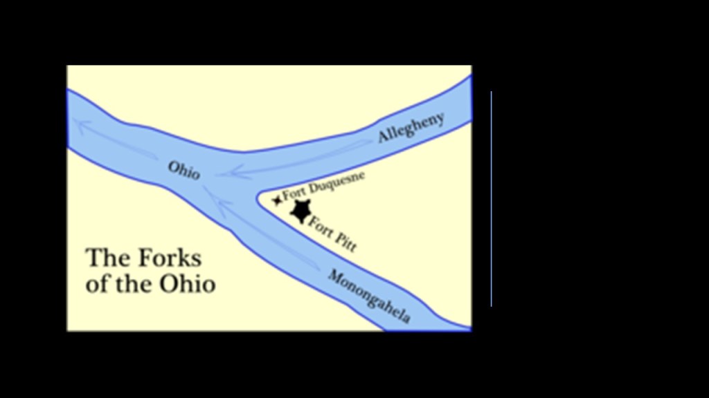
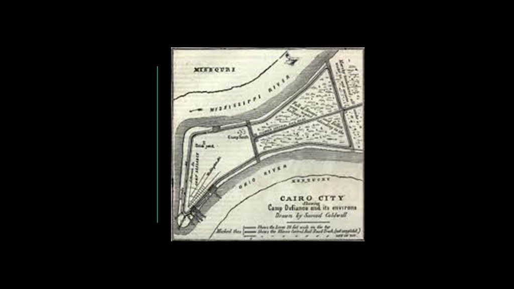
What I find interesting about finding “John Brown’s Fort” at this location is that I typically find either still-existing or historic star forts at the point of river confluences like here in Harper’s Ferry.
Examples include Fort Pitt and Fort Duquesne at the “Forks of the Ohio” in Pittsburgh…
…and the historic first Camp, and later Fort, Defiance at the confluence of the Mississippi and Ohio Rivers in Cairo, Illinois, to name two of countless examples.
Before I continue following the C & O Canal and B & O Railroad along the Potomac River, I just want to take a quick look at some places on the Shenandoah River-side.
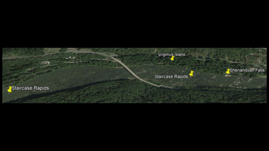
Going from left-to-right along the Shenandoah River in this Google Earth Screenshot, starting with Virginius Island; the Staircase Rapids; Shenandoah Falls, and the original site of the Shenandoah River Bridge.
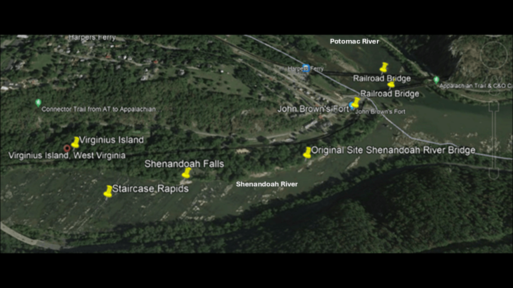
First, Virginius Island.
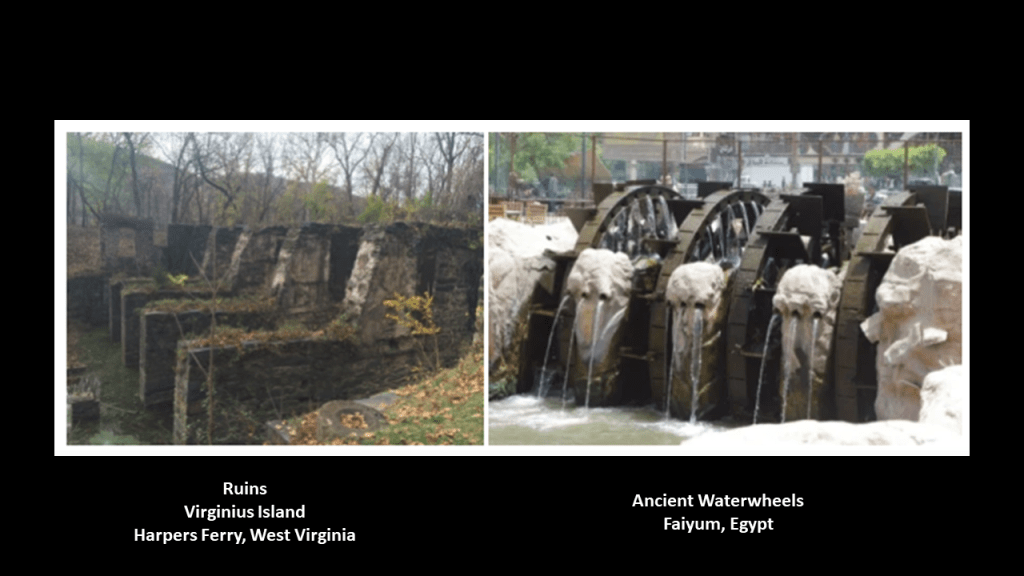
We are told Virginius Island was a thriving industrial location in the first-half of the 19th-century, after Virginius Island was created by the Patowmack Company when it was constructing the Shenandoah Canal between 1806 and 1807.

Besides the railroad that ran across Virginius Island, other industries that were said to have been here included a wide-range of mills and factories. and that at its peak in 1850, there were 180 people living here in 20 houses.
Here are some of the stone ruins found today on Virginius Island.
Compare the photo on the left taken at Virginius Island in Harpers Ferry identified as “pulp factory ruins;” and on the right, ancient waterwheels found in Faiyum, Egypt.
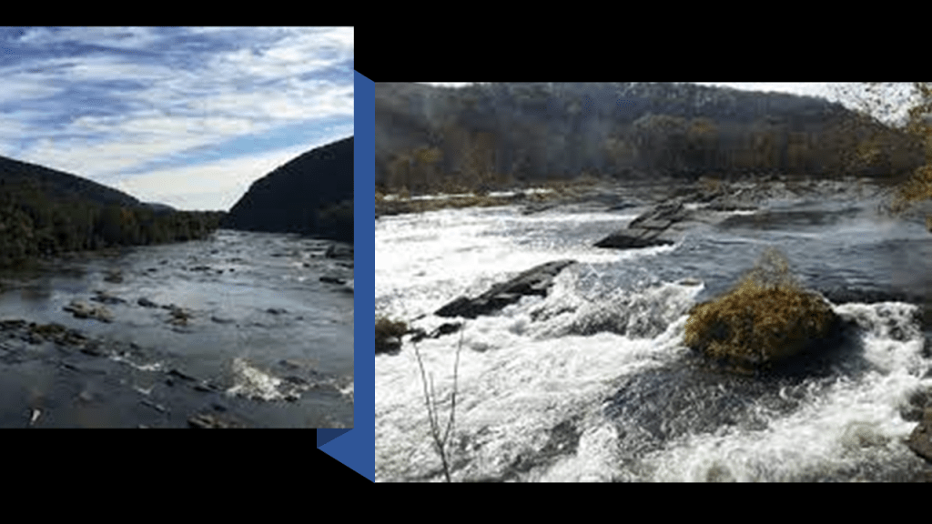
Next, the “Staircase Rapids.”
What are called the “Staircase Rapids” run along the Shenandoah River a distance through this stretch of the river, consisting of the “Upper Staircase” and the “Lower Staircase,” towards a section of the river classified as “Shenandoah Falls.”
I’m sure I went over these rapids on a group whitewater rafting trip when I was a teenager and part of a very active youth group at my church where we went on all of these fun outings together.
Reflecting back on it, these were experiences I would not have otherwise had, and I am grateful that I was able to have them.
At any rate, I now believe that rapids, and waterfalls, played a functional role on the original energy grid as well as part of an advanced hydroelectric system, and the locations I am looking at in this post are a microcosm of the same infrastructure and design that is found all over the Earth that has been hidden from us.
What comes to mind about rapids and energy grid infrastructure is the Leander Colt Incline Railway .
It was said to have been built on the Canadian-side of the Niagara Falls in 1869, near the Whirlpool Rapids Bridge, but damaged and abandoned 20-years later in 1889.
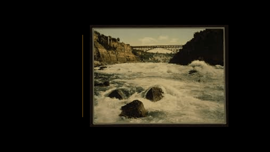
Another Whirlpool Rapids Incline was said to have been built in 1876 near the Leander Colt Incline, but damaged by fire in 1934 and replaced by the “Great Gorge Trip” of the Niagara Belt-Line, a train route around Niagara Falls…

…which later became the “White Water Walk” where you can take a leisurely stroll where the Niagara Belt-Line once was.
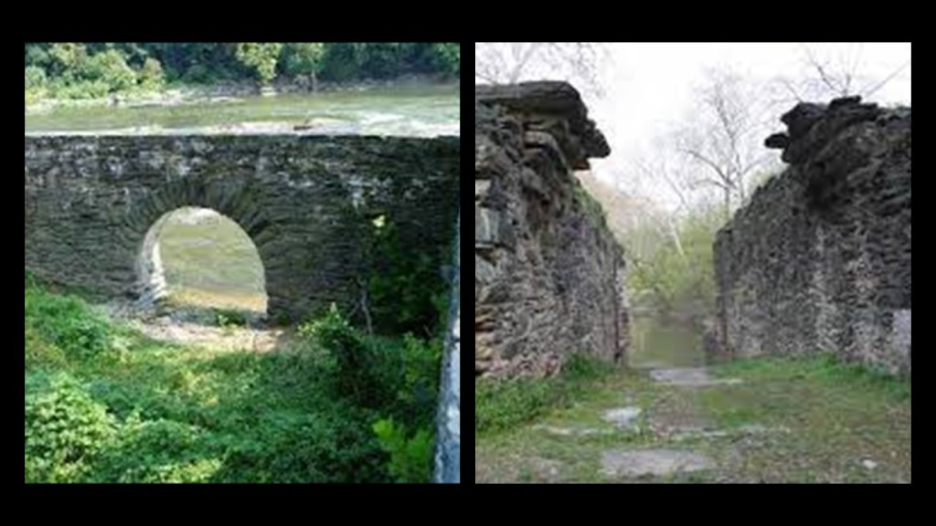
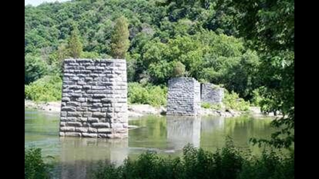
Next, there are ruins the ruins of two historic bridges at the confluence of the two rivers – original Shenandoah River Bridge abutments and abutments for the former Bollman Bridge, another railroad bridge that was next to the two existing railroad bridges crossing the Potomac River.
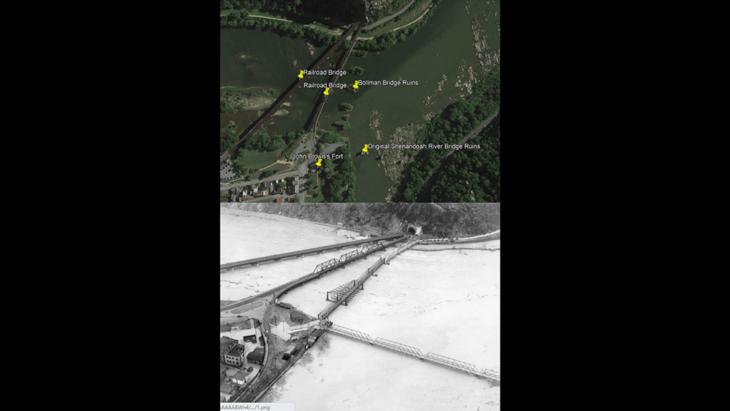
The original Shenandoah River Bridge was said to have first been a wagon-road bridge and later a vehicle bridge that was completely destroyed by a flood in 1936, the worst of six known floods starting in 1748.
The 1936 flood crested at 36.5-feet, or 11-meters.
Along with the Shenandoah River Bridge and many businesses in the Lower Town of Harpers Ferry…
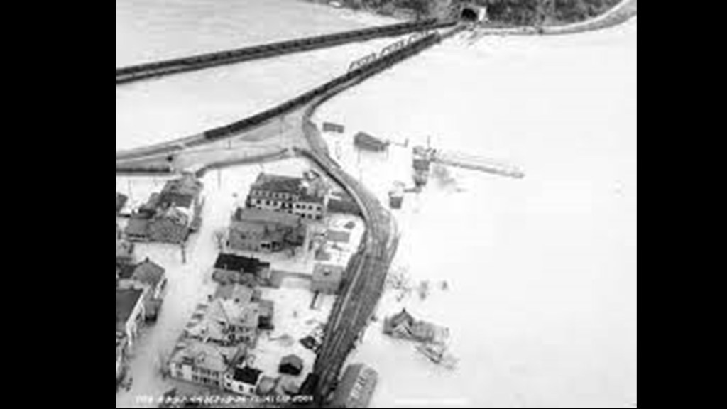
…the Bollman Railroad Bridge was completely wiped away in the same flood.
Both ruined bridges were also said to have suffered damage during the Civil War, but rebuilt for use until they were completely wiped out by the floodwaters in 1936.
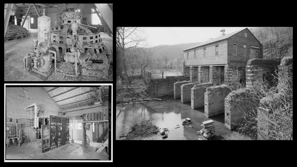
Now heading up the Potomac River from the confluence of the two, the Potomac has rapids through here, as well as a Hydroelectric Power Plant.
It was said to have been built in 1888, and operated from 1899 to 1991, and was originally part of a wood pulp mill, and after a fire in 1925, operated only as a power house.
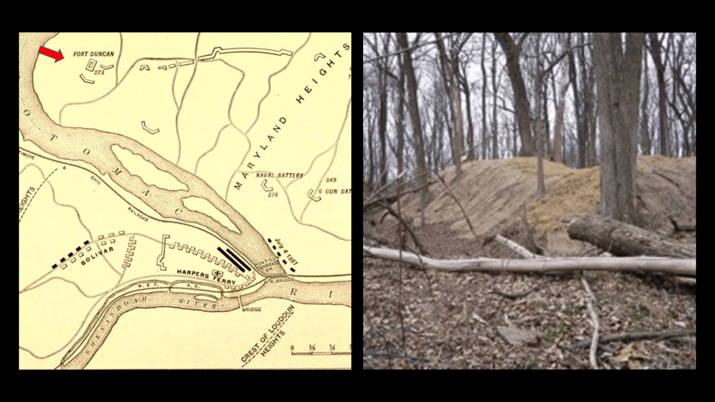
Following the Potomac River from the old power plant ruins, we soon come to Lock 34; Dam 3 ruins; and Fort Duncan.
The railroad tracks follow the Potomac River up until the river bend at the Dam 3 Ruins, and then veer off across the countryside.
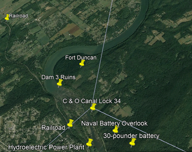
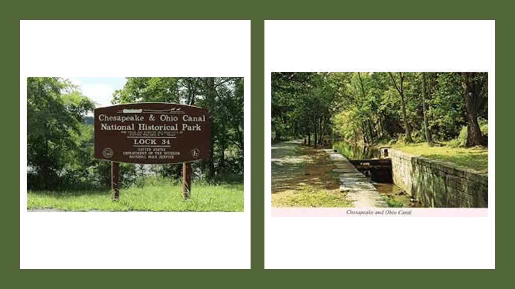
The C & O Canal Lock 34 is at mile 61.5 of the canal’s towpath, just north of Harpers Ferry.
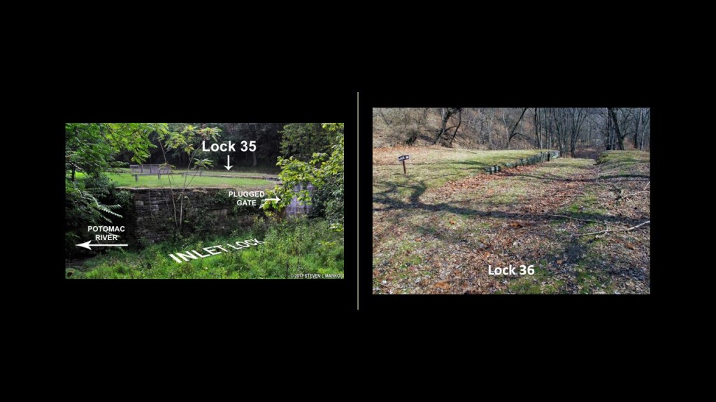
The next place we come to on the Potomac River after Lock 34 are the ruins of Dam 3, an inlet lock, Lock 35, and Lock 36 around mile 62 of the canal towpath.

Dam 3 was said to have been built in 1799 to serve the Armory at Harpers Ferry.
The dam was said to be ineffective; rebuilt once in 1820; and then in 1832, used by the C & O Canal for its purposes.
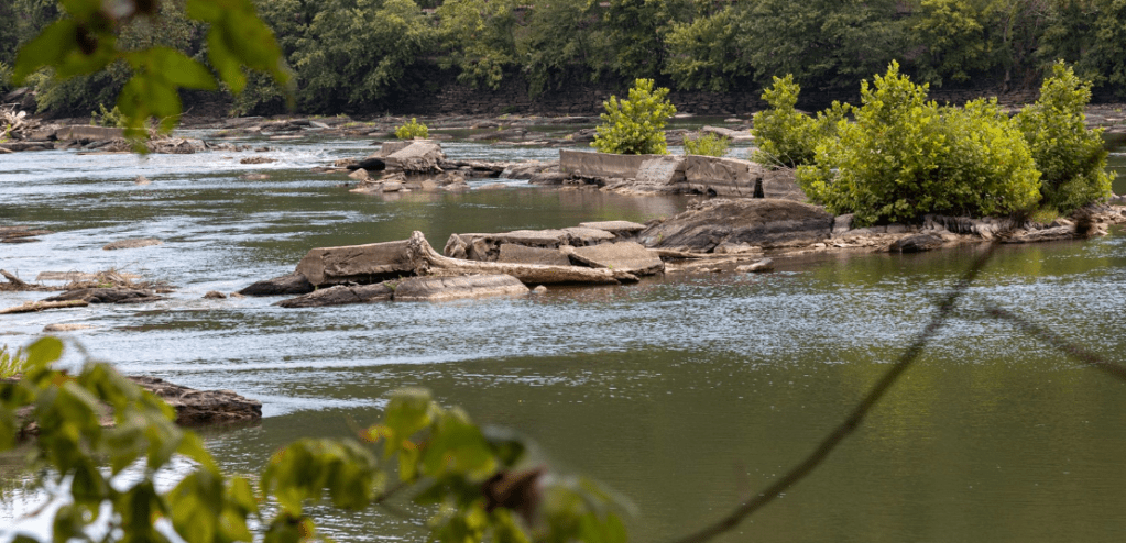
The Inlet Lock, Lock 35 and Lock 36 are in close proximity to the ruins of Dam 3.
The historical location of Fort Duncan is less than a half-mile north from the location of the Dam 3 ruins and the lock infrastructure, up a steep hill.
It was said to have been constructed by the Union Army in October of 1862 shortly after the Battle of Antietam and the Union surrender of Harper’s Ferry to the Confederate Army under the command of General Stonewall Jackson.
Its stated purpose was to guard the area around Harpers Ferry, the railroad and the canal.
The only action seen there was reported to have been a small demonstration following the Confederate General Jubal Early’s raid on Washington in 1864.
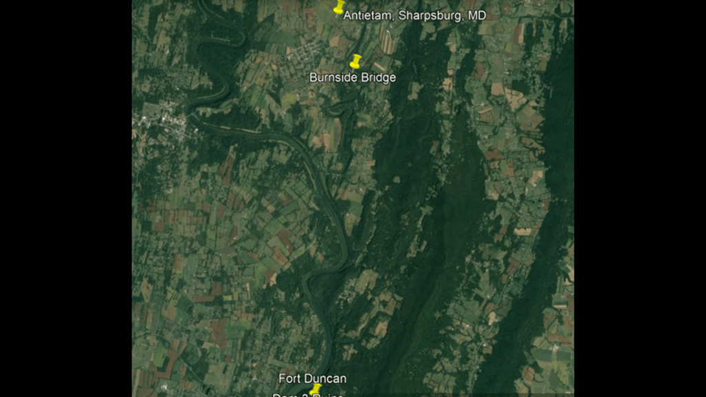
Leaving the historic location of Fort Duncan, we are heading north to the battlefield of Antietam in Sharpsburg, Maryland, and Antietam Creek.
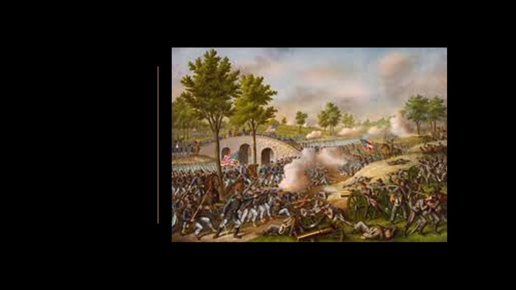
I remember visiting Antietam with my family when I was young, and then went there in 2004 when visiting a friend who lives in the area, and got an up-close and personal with the Burnside Bridge because I photographed it and later painted it.
More on the Burnside Bridge in a moment.
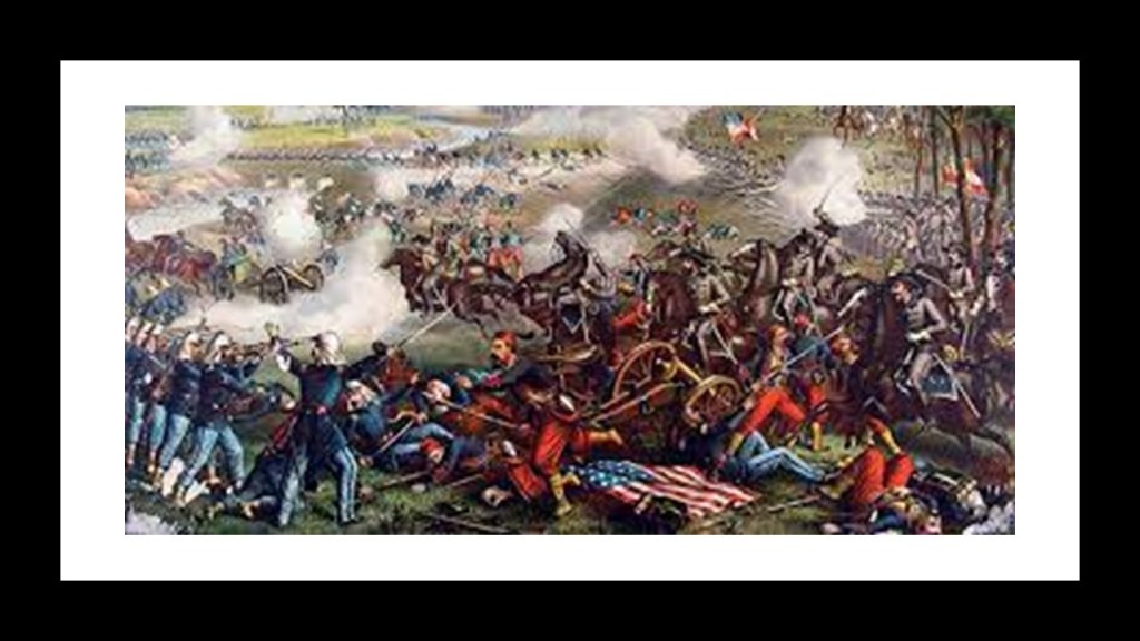
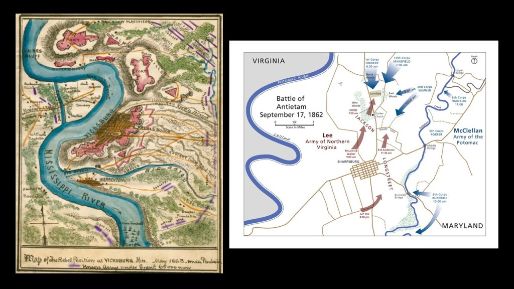
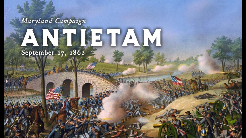
We are told that Antietam was the deadliest one-day battle in American Military History, on September 17th of 1862, with 22,727 dead, wounded, or missing.
The battle was fought between the Confederate troops of General Robert E. Lee’s Army of Northern Virginia and the Union troops of General George McClellan’s Army of the Potomac.
We are told Lee’s Army advanced into Maryland on September 3rd, after their victory on August 30th at the Second Battle of Bull Run in Northern Virginia.
McClellan’s troops were there to intercept them and by September 17th had the Confederate troops in defensive positions behind Antietam Creek.
After a long bloody day of fighting and death, the Union Army succeeded in turning back the Confederate invasion of Maryland, and was considered a major turning point in the war in the Union’s favor.
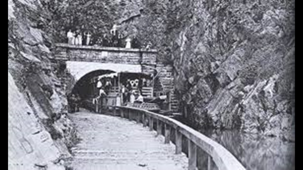
The Battle of Burnside Bridge took place in the afternoon that day to capture the bridge, which was dominated by a wooded bluff on the west bank and strewn with “boulders from an old quarry,” impeding the crossing of the bridge by combatants because this provided good cover.
The attempts of the Union Army troops under the command of Major-General Ambrose Burnside failed to secure the bridge and resulted in a considerable loss of life.
Compare the appearance of the Burnside Bridge on the left with that of the Sligachan Bridge on the Isle of Skye off Scotland’s northwest coast on the right.

The last section of the Potomac River and C & O Canal I am going to look at is a cluster of Hydroelectric and reservoir infrastructure to the northwest of Sharpsburg and the Antietam battlefield.
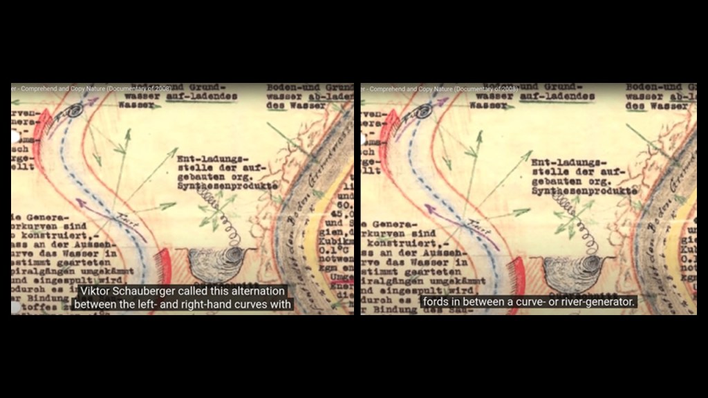
There is a series of S-shaped river bends through here that I see all over the Earth and long-believed also have a functional purpose on the Earth’s grid system…
…and you see the same S-Shaped river bends on the Mississippi River where the Battle of Vicksburg in Mississippi was said to have been fought in the Civil War that you have on the Potomac River where the Battle of Antietam was fought.
Viktor Schauberger’s work involved the hydrodynamics of S-shapes.
He was an Austrian scientist who was a pioneer in the field of water and energy research in the early 20th-century, and he specialized in the flow of water and natural energies.
Between 1928 and 1935, he worked on developing a device for the production of living water, water with an enhanced structure and necessary minerals.
Schauberger described the twisting and turning motions of water courses as energizing the water.
Conversely, he believed that modern industries destroy healthy water, including the processes of municipal water treatment plants, which decompose healthy water.
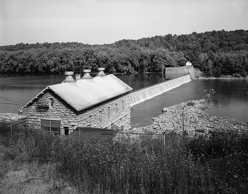
The infrastructure found along the Potomac River and C & O Canal here includes the Power Plant & Dam 4 and the Potomac River Reservoir.
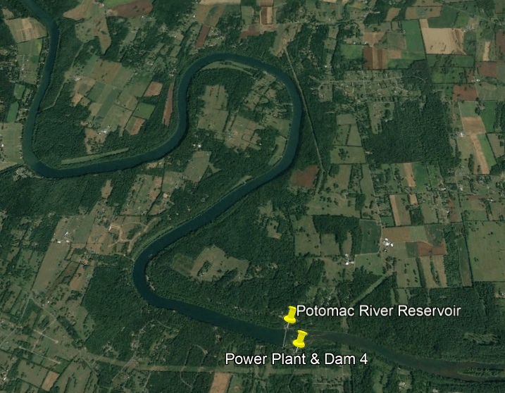
The Power Plant and Dam 4 is an historic hydroelectric power generation station on the Potomac River, and part of the Potomac River Reservoir.
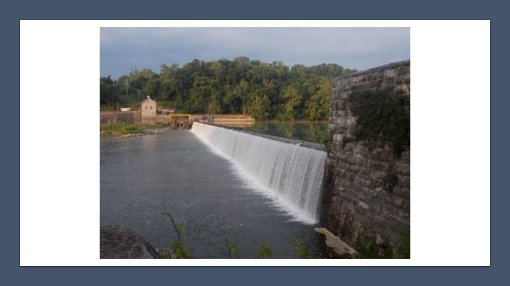
The Power Plant is a limestone building on a high stone foundation built into the hillside. that is five-bays long and a gable-roof said to have been built in 1909.
Dam 4 was said to have originally been built starting in 1832 and completed in 1835 for the C & O Canal, and that it started supplying hydroelectric power in 1913.
Today it is owned by the National Park Service and leased to the Potomac Edison Electric Company for electric power generation in Washington County, Maryland.
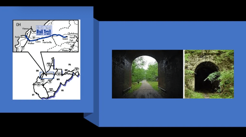
The Great Tunnel of the C & O Canal is in Allegheny County, Maryland, and part of the Paw Paw Bends section of the Potomac River as it winds its way through West Virginia and Maryland, not far from the Antietam National Battlefield in Maryland.
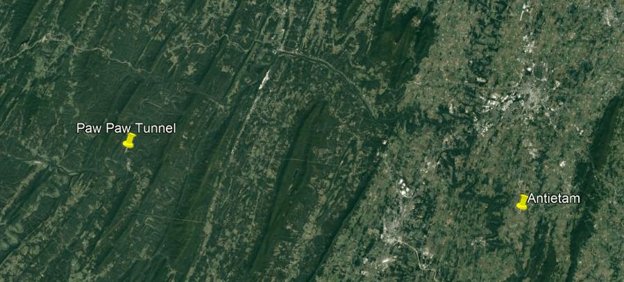
Built using more than 6,000,000-bricks, this tunnel has been described as the “greatest engineering marvel along the Chesapeake and Ohio Canal National Historical Park.”

The Paw Paw Tunnel was said to have been built between 1836 and 1850 for the C & O Canal to by-pass the bends in the Potomac River, with no work having been done on it between 1841 and 1847 due to construction and financial problems.
The C & O Canal closed to canal boats in 1924.
We are told that the C & O Canal, and other canals, were made obsolete because the railroad was so much more efficient and canals couldn’t compete with them.
Like the Wabash and Erie Canal in Indiana, among countless others, which was said to have been built during roughly the same time period as the C & O Canal.

Canals like the C & O Canal subsequently became a popular hiking, biking and canoeing venue, as we also see with the rails that quietly became trails when no one was paying attention.
This changed the energy flow from what the original integrated energy system was generating to power the electrical grid…to human energy.
We may not be all of it, but we are definitely a part of it.

So, exactly how do you go about hiding giants and their advanced civilization?
Based on the information I have provided throughout this post and past research, I think the American Civil War was another one of the many ways this was done, and was not what we are told it was about.
For another example of finding correlations between giants and civil war battles is this article on the bones of giant indians near Antietam Creek.
Titled “Bones Of Giant Indians,” about giant skeletons found in Antietam, it was originally published on February 9th of 1898 in the “Juniata Sentinal and Republican” newspaper in Mifflintown in Juniata County, Pennsylvania, and can be found on the Library of Congress website
This article implies that the tall skeletons that were found of seven-feet in height, of indians that had roamed over the State of Maryland in their wildness, armed with instruments that either nature gave them, or in their limited skill to make.
It further goes on to say that the locality from where these skeletons came near Antietam Creek in Frederick County was supposed to have been the battleground of two tribes of Indians, the Catawabas and the Delawares.
According to this claim, some Catawbas overtook a band of Delawares living at the mouth of the Antietam and annihilated them, but Dr. Philip Uhler, President of the Maryland Academy of Sciences and Provost of the Peabody Institute, after a careful review of the locality, found that there was no evidence to support this claim of a battle other than some spears and arrowheads found there.

This location of Antietam Creek and the alleged battleground between the two Indian tribes would not have been far in distance from the location of the Battle of Antietam.
So exactly how was Dr. Philip Uhler supposed to find any evidence around 1898 of an historical battle between giant Indians in a place with an even more recent battle in 1863, and of this magnitude?.
The Peabody Institute mentioned in this article immediately caught my attention.
In 1857, banker, and also called the “Father of Modern Philanthropy,” George Peabody established the Peabody Institute in Baltimore with a bequest of at least $800,000, and it is the oldest conservatory in the United States.
By the time it was completed and opened in 1866, one year after the official end of American Civil War, it was dedicated by George Peabody himself,and included a music academy, library and art gallery.
That entrance at the east wing of the George Peabody Library sure looks proportionally like it’s made for much bigger people than we are today!

George Peabody’s bank became the premier American banking house in London after he took up residence from Baltimore to London permanently in 1837, and went from being a wholesale dry-goods and cotton merchant, to a merchant-banker offering securities in American railroad and canal enterprises to British and European investors.
He started a banking business trading on his own account a year after he moved to London, and by 1851, he established the banking firm of “George Peabody & Company” to meet the increasing demand for securities issued by American railroads, and his company specialized in financing governments and large companies.

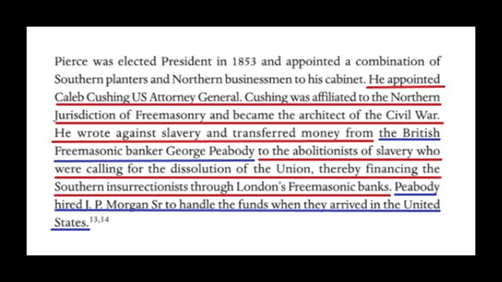
According to “The Secret Founding of America” book by Nicholas Hagger…

…George Peabody was the Freemasonic banker from whom money was transferred to the “southern insurrectionists,” and he hired the father of J. P. Morgan to handle the funds when they arrived in the United States.
So as I have been showing throughout this post, the events in our historical narrative about the Civil War in the Greater-area around Harper’s Ferry, take place in a location noteworthy for its historic forts, rivers, canals, railroads, and hydroelectric plants.
The original rail-lines and canals would have been providing power for the free-energy system, and the original infrastructure would have provided the antiquitech to process and utilize the free energy throughout the worldwide system.
The Original Energy Grid system was based on exact and precise geometric alignments of cities and places all over the Earth.

Other examples places with the same infrastructure found at Harper’s Ferry is”The Soo,” the nickname given to the Sault Stes. Marie of Michigan and Ontario, and the Niagara Falls region between New York State and Ontario.
First, “The Soo.”
The city of Sault Ste. Marie was said to have been founded by the French Jesuit missionary, Father Jacques Marquette, in 1668. It was said to be named for both the “Sault,” the name given to the St. Mary’s River rapids, and the Virgin Mary, and called the first European city in the Great Lakes Region.
Sault Ste. Marie was one city until the border between the United States and Canada was established at the St. Mary’s River in a treaty after the War of 1812, creating Sault Ste. Marie, Michigan, and Sault Ste. Marie Ontario, and on both sides of the river, the area is referred to as the “The Sault” or even “The Soo.”
Sault Ste. Marie is the oldest city in Michigan, and said to be the third-oldest city in the United States.
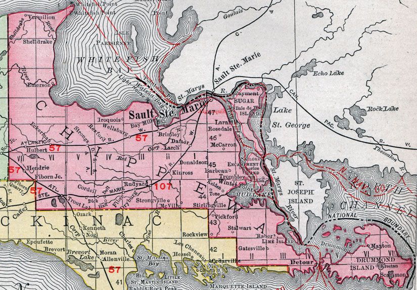
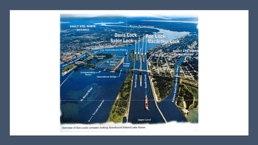
The Soo Locks, the largest waterway traffic system on Earth, are called the “Linchpin of the Great Lakes,” allowing ships to travel between Lake Superior and the lower Great Lakes. Lake Superior meets Lake Huron with a 21-foot, or 6.4-meter, drop in elevation.
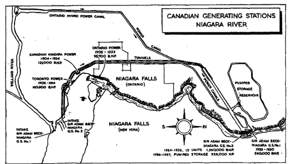
Next, Niagara Falls.
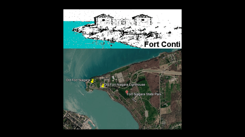
In our historical narrative, we are told Europeans started entering the Niagara River-area between Lake Ontario and Lake Erie in the 17th-century, with Frenchman Robert de la Salle given the credit for building Fort Conti at the mouth of the Niagara River in 1679, as a base for exploring for the Northwest Passage to Japan and China to extend France’s trade.
The location we are given for Fort Conti is Old Fort Niagara where the Niagara River meets Lake Ontario.
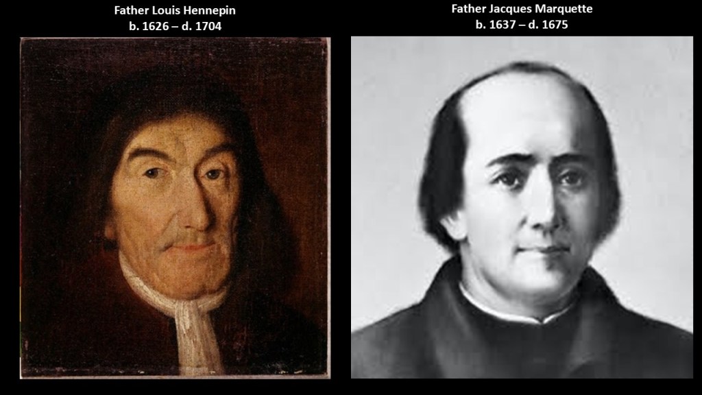
Robert de la Salle was accompanied by Belgian priest, missionary, and explorer of the North American interior, Franciscan Father Louis Hennepin, said to have been the first European to see the Niagara Falls.
Father Hennepin was a contemporary of the French Jesuit Father Jacques Marquette, who besides founding Sault Ste. Marie, explored all over Lake Superior, Lake Michigan and Green Bay in our historical narrative.
Niagara Falls has been called a “Hydroelectric Mecca.”
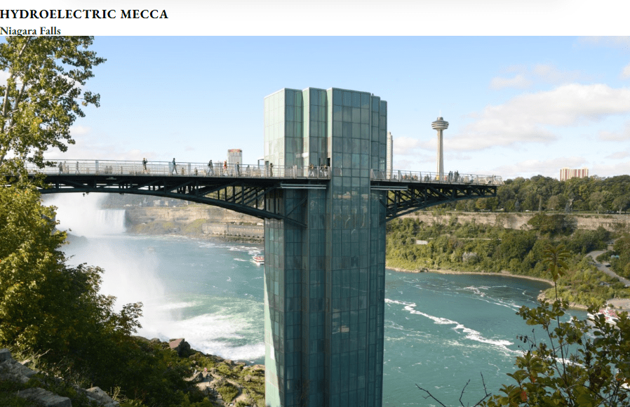
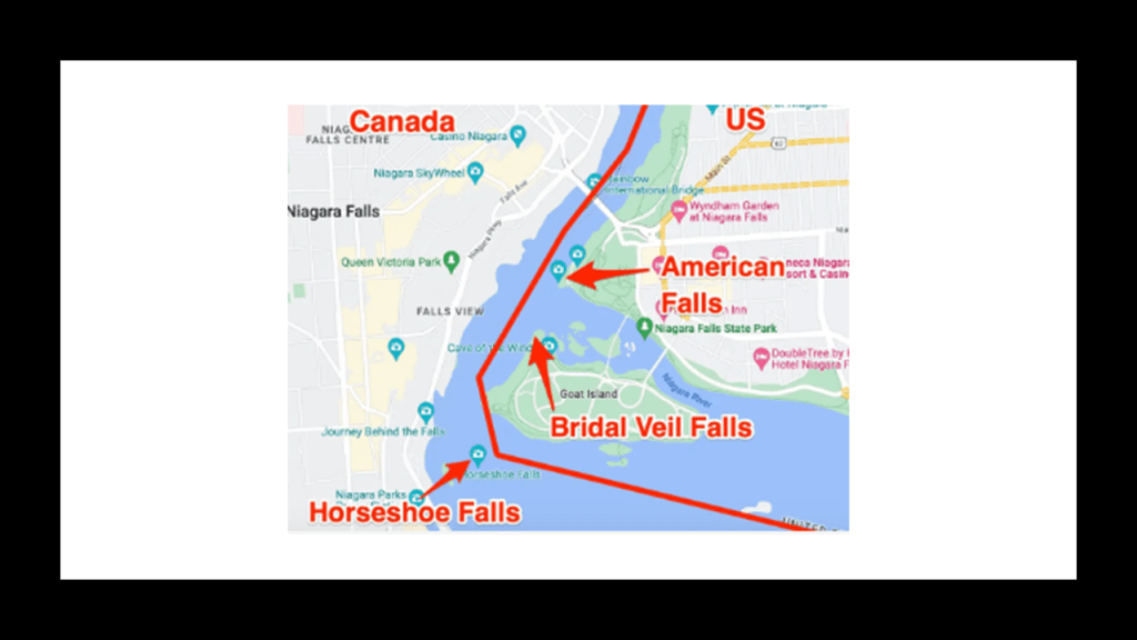
Niagara Falls, the largest waterfall by volume in North America, consists of a group of three waterfalls on the Niagara River spanning the international border between New York and Ontario – Horseshoe Falls in Ontario and Bridal Veil Falls and American Falls in New York.
3,160-tons of water flow over all three of the Niagara Falls every second, with water plunging 32-feet, or 10-meters, hitting the base with 280-tons of force at the American and Bridal Veil Falls, and 2,509-tons of force at the Horseshoe Falls.
Niagara Falls is capable of producing 4-million kilowatts of electricity, which is shared by the United States and Canada, and is also noteworthy for its present-day and historic hydroelectric and power-generation facilities.
This is what I have come to believe has taken place here over the course of my eight-years of research.
Firstly, I believe that those behind the reset of Earth’s history and the New World Order deliberately caused a cataclysm via some form of directed frequency or energy into the grid system relatively recently, which destroyed the entire energy grid and devastated the surface of the Earth, simultaneously causing the land to undulate and buckle.
This caused, among many other things, swamps, bogs, deserts, dunes, and whole land masses to shear-off and submerge under lakes, seas and oceans, and that the European colonizers we learn about in our history were exploring and claiming the land of a post-cataclysmic world.
Secondly, I believe that the original civilization of the Earth was nothing at all like what we have been taught, even though the clues and evidence for the highly-advanced, original ancient advanced Moorish civilization surround us all over the Earth.

We don’t recognize the clues and evidence as such because we have no points of reference for them because Earth’s True History is not included the historical narrative we have been given, and instead have been given a fictional explanation for our history and how everything came to be in our world.

In my post “The Backfill of History and the Shaping of Our New Historical Narrative,” I have expressed my belief among other things that famous authors were being used as programming devices with which to shape our collective minds with a new historical narrative and history that we have been thoroughly educated in, and completely covering up what was once a worldwide ancient, advanced Moorish Civilization.
I have identified a 450-year timeline between the Fall of the Moors in Granada in 1492, and 1942, midway through World War II, with 1717 as the mid-point year, that I believe our new false paradigm was based on, and believe that at some point in our narrative, world history has been fabricated and backfilled, and that at some point in our relatively modern history, likely sometime in the 1700s, history became real with the Controllers writing themselves in to the new historical narrative.
Thirdly, I believe the beings behind the cataclysm were shovel-ready to dig enough of the original infrastructure out of the ruined Earth so they could be used and civilization restarted, which I think started in earnest in the mid-to-late 1700s and early 1800s.
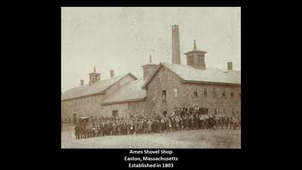
It’s important to note that the Ames Shovel Shop was established in Easton, Massachusetts, in 1803.
It became nationally known for providing the shovels for the Union Pacific Railroad, which we are told opened the West.
It was said to have been the world’s largest supplier of shovels in the 19th-century.
The year of 1803 that the Ames Shovel Shop was established was in the same time-period as the following historical events.
The Lewis & Clark Expedition, also known as the Corps of Discovery, started on May 14th of 1804 and lasted until September 25th of 1806, with a mission to explore and map the newly acquired western portion of the country after the Louisiana Purchase.
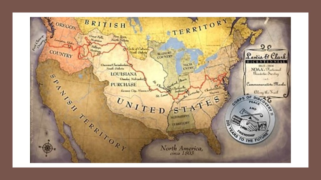
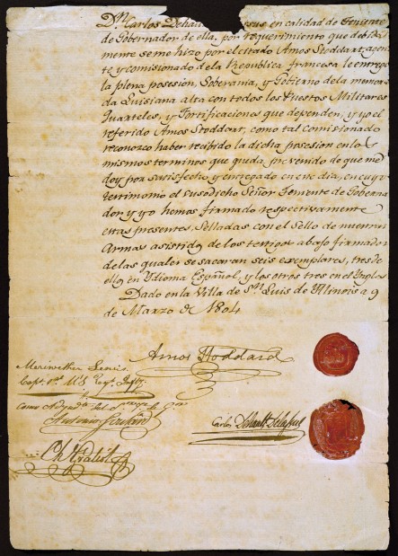
We are told the Louisiana Purchase was the acquisition of the Territory of Louisiana by the United States from France with the signing of the Louisiana Purchase Treaty on April 30th of 1803, which was officially announced on July 4th of 1803.
It was said to have doubled the size of the United States and paved the way for the nation’s westward expansion.
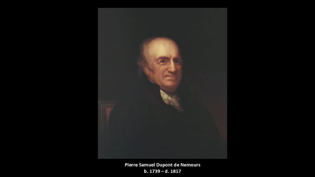
One of the negotiators with France for the terms of the Louisiana Purchase in 1803 on behalf of President Jefferson was the minor French nobleman Pierre Samuel Dupont de Nemours, who was living in the United States at the time.
His son Éleuthère Irénée du Pont, a chemist and industrialist, founded the E. I. du Pont de Nemours and Company to manufacture gunpowder and explosives in 1802, with the du Ponts becoming one of America’s richest families, with generations of influential businessmen, politicians and philanthropists.
So besides the Ames Shovel Shop and the Louisiana Purchase showing up in our narrative in 1803, and the Lewis and Clark Expedition to explore the Pacific Northwest from 1804 until 1806; we have the founding of the DuPont gunpowder and explosives company in 1802 in Wilmington, Delaware.
So two products were established at the very beginning of the 1800s that you would need to dig-out infrastructure – shovels and explosives.
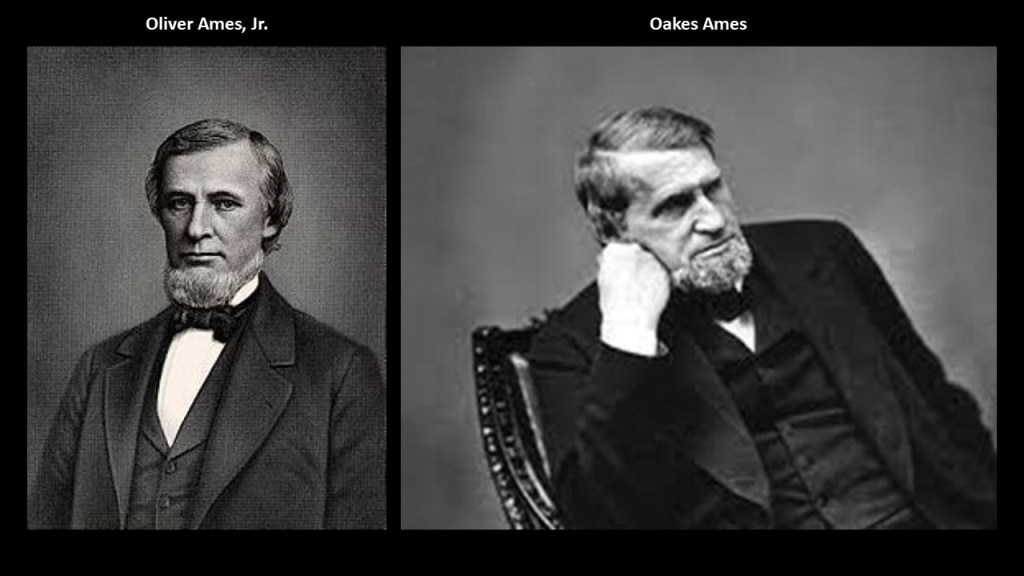
The co-owners of the Ames Shovel Shop at the time the railroads were being brought on-line were the Ames Brothers.
Oliver Ames, Jr, (b. 1807 – d. 1877) was the President of the Union Pacific Railroad from when it met the Central Pacific Railroad in Utah for the completion of the first Transcontinental Railroad in North America in 1869, just four-years after the end of the American Civil War.
The other brother, Oakes Ames, was a member of the U. S. Congress House of Representatives from Massachusetts 2nd District from 1863-1873.
Oakes was credited by many as being the most important influence in building the Union Pacific portion of the first Transcontinental Railroad.
The Pacific Railroad Surveys, a series of explorations of the American West between 1853 and 1857, just a few years before the beginning of the American Civil War, had the stated purpose of finding and documenting possible routes for a transcontinental railroad across North America.
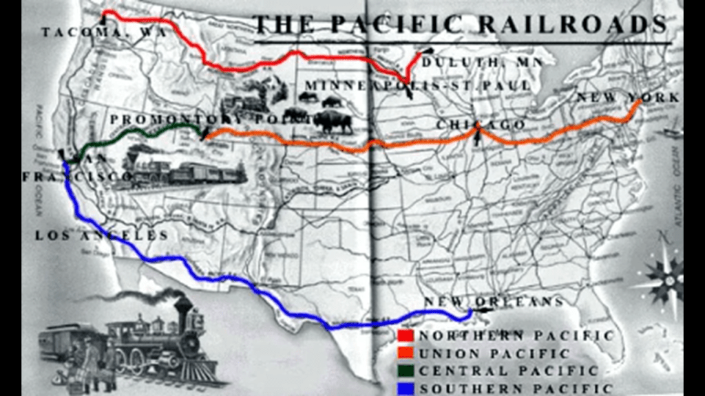
There were five surveys conducted: the Northern Pacific Survey from St. Paul, Minnesota, to Puget Sound; the Central Pacific Survey from St. Louis, Missouri, to San Francisco, California; the Southern Pacific Survey from Oklahoma to Los Angeles, California; the Southern Pacific Survey across Texas to San Diego, California; and along the Pacific Coast from San Diego, California, to Seattle, Washington.
All were carried out under the direction of the U. S. Secretary of War Jefferson Davis, the future President of the Confederacy during the American Civil War.
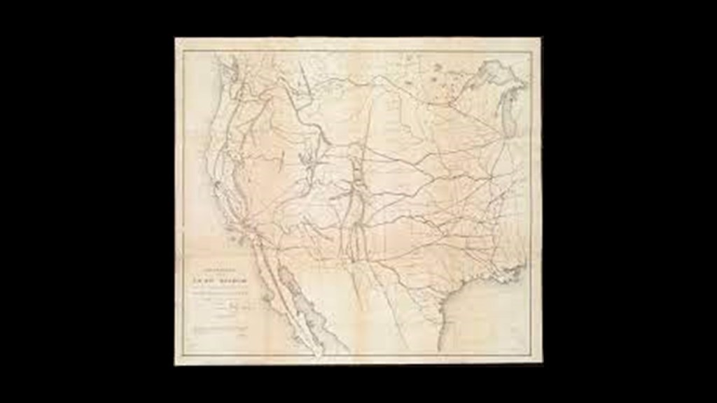
We are told the volumes of information that were produced from these surveys were considered to constitute the single most important contemporary source of knowledge on western geography and history, and that their value was greatly enhanced by beautifully-illustrated color plates showing the scenery, native inhabitants & fauna and flora of the West.

What if the Pacific Railroad Surveys were undertaken to explore a ruined landscape surveying, as in the definition of surveying meaning “looking at and observing,” everything, including pre-existing rail infrastructure in order to restore it to use once again?
What if the deserts in North America weren’t always deserts as we have been taught to believe?

By May of 1869, just four-years after the end of the American Civil War, the first Transcontinental Railroad in North America was completed with the hammering of the “Golden Spike” connecting the Union Pacific Railroad with the Central Pacific Railroad at Promontory Summit in what was then the Utah Territory.
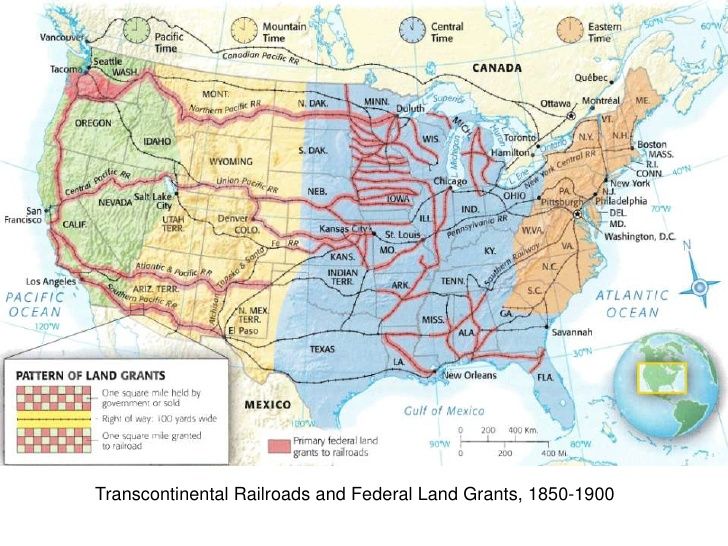
We are told that the federal government operated a land-grant system between 1855 and 1871, which included the years of the American Civil War between 1861 and 1865, where new railway companies in what we are told was the uninhabited west were given millions of acres they could sell or pledge to bondholders.
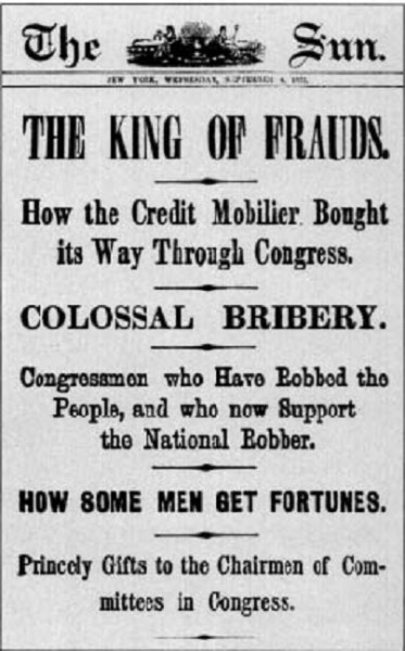
Oakes Ames was also noted for his involvement in the Credit-Mobilier Scandal of 1867 during the time of the land-grant system, regarding the improper sale of stock of the railroad’s construction company.
He was formally censured by Congress in 1873 for this involvement, and he died in the same year.
Ten-years later, he was posthumously exonerated by the Massachusetts State Legislature on May 10th, 1883.
Early bankers like the previously mentioned George Peabody and the Brown Brothers & Company were heavily-involved in financing the railroads.
This is what we are told about Brown Brothers & Company: during the first 100-years of its existence, it helped make paper money standard currency in the United States; underwrote the first railroad and trans-Atlantic steamship companies; and essentially created the first foreign exchange system between the American dollar and the British pound.

Why were shovels and explosives so important to the opening of the West and the expansion of infrastructure?
It is my belief that all of this exploration, surveying, and so-called railroad construction took place in a post-cataclysmic world of recent occurrence and that the railroad tracks were already there and just needed to be dug out.

Then they only used the pre-existing infrastructure until they found replacement fuel sources that could be monetized and controlled by them for what had originally been a free-energy power grid and transportation system worldwide, and when what remained of the original infrastructure was no longer useful to them, or inconvenient to their agenda, they had it destroyed, discontinued, or abandoned, typically in a very short time after it was said to have been constructed.
I think there was a hostile take-over of the Earth and it’s grid system, which was reverse-engineered as a mind-control and energy-harvesting system for human energy known to us as “The Matrix.”

A sudden cataclysmic event, creating swamps, deserts, and even submerging entire landmasses around the Earth, would account for how a highly advanced worldwide civilization of giants could be wiped from the face of the Earth and erased from our collective memory and a new historical narrative superimposed over the ruins of the Old World so we would know nothing about it.

Harper’s Ferry Iowa is home to the effigy mounds the narrative here is they brought basket after basket of soil all the way up these 400 ft high bluffs to make these effigies….. Also all the bridges around this area are being rebuilt at the moment which seems sus.,. They’re also offering to put in cheap impoundments/ponds for farmers which are changing the natural water flow and I’m concerned along with all the sick moldy trees falling everywhere there will soon be a bunch of mud slides like they did to Appalachia mountain folks opening all the dams and manipulating the weather to have the land as they’ve tried for years because of the lithium and quartz in the mountains to create their smart cities…. We need a global bottoms up movement! I promise you we all need to come together as he has figured out how to destroy them using physics! We need you and your followers and everyone else who’s awake. If I’m wrong you can shoot me 333.33 times in the face
On Fri, Jun 5, 2026, 9:11 AM Revealing What Has Been Hidden in Front of Our
LikeLike