
I am still drawing from the long list of places that viewers have brought to my attention in comments and/or sent me pictures and information for places to research in the fourth part of this series.
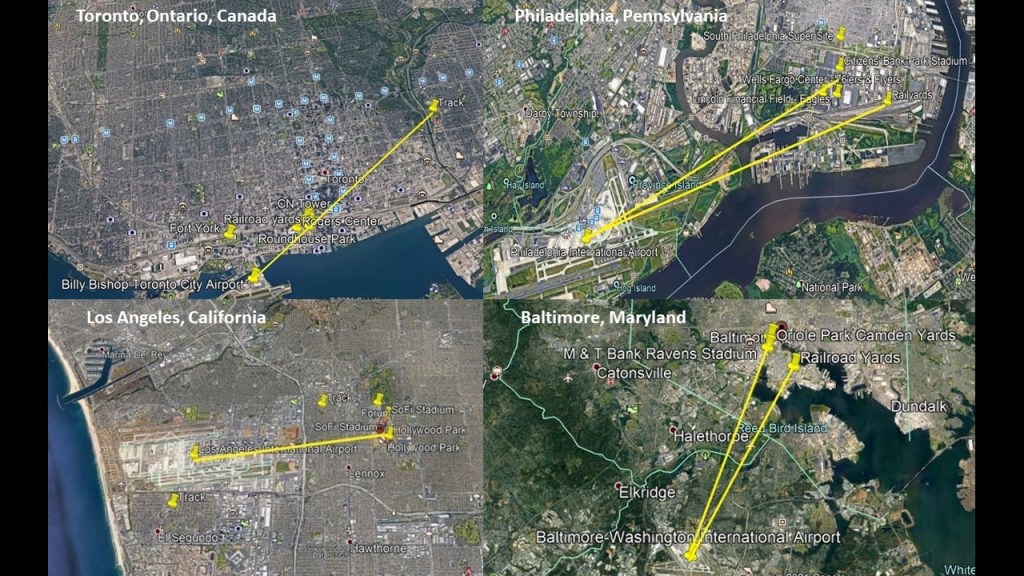
I have received more suggestions from viewers since the last post on the subject of airports having racing tracks in angular relationships short distances away that I have already seen in the first three parts of this series – in places like Shepherd’s Bush District of West London; the Sulphur Springs neighborhood in Tampa, Florida; in Montreal, Quebec, Canada; Philadelphia, Pennsylvania; Toronto, Ontario, Canada; Los Angeles, California; and Sydney, Australia, so this subject will be my starting point yet again.

In addition to airports and racetracks, I am also finding things like railroad yards, professional sports complexes, star forts and even amusement parks with the similar characteristics and relationships to each other that I am finding in different cities around the world.
In these Google Earth screenshots, all the lines drawn go through or to professional sports complexes, and railyards in Toronto, Philadelphia, and Baltimore.
I am going to start with this comment that a viewer in Denmark left me:
“Same thing here in Copenhagen, there is a racetrack in Kastrup, just around the same area as Copenhagen Airport!”
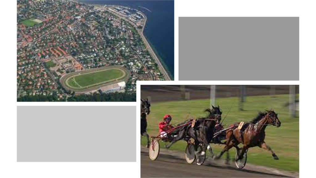
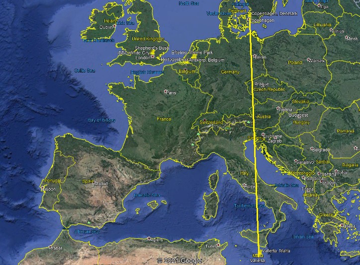
This is what I found on Google Earth the first time when I located Kastrup International Airport and some of the race tracks in Copenhagen.
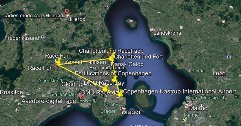
Then the second time, I found an additional race track and star fort, as well as an amusement park, that I didn’t see the first time I looked.
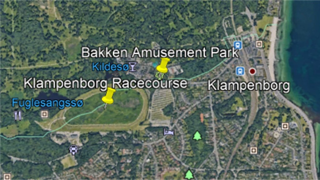
For the purposes of this post, I am going to focus on the quadrant northeast of the airport because it has a number of noteworthy features.
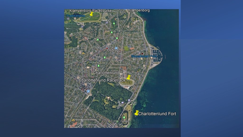
I am going to start with the Klampenborg Racecourse and Bakken Amusement Park and work my way down towards the Kastrup International Airport.
The Klampenborg Racecourse is a flat horse-racing track that first opened in 1910 in this affluent Klampenborg suburb of Copenhagen.

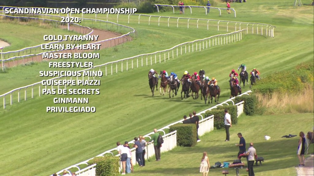
Major races held at the Klampenborg Racecourse include the Scandinavian Open Championship, in which 3-year-old and over thoroughbred horse racing takes place annually in August.
The Bakken Amusement Park is adjacent to the Klampenborg Racecourse…
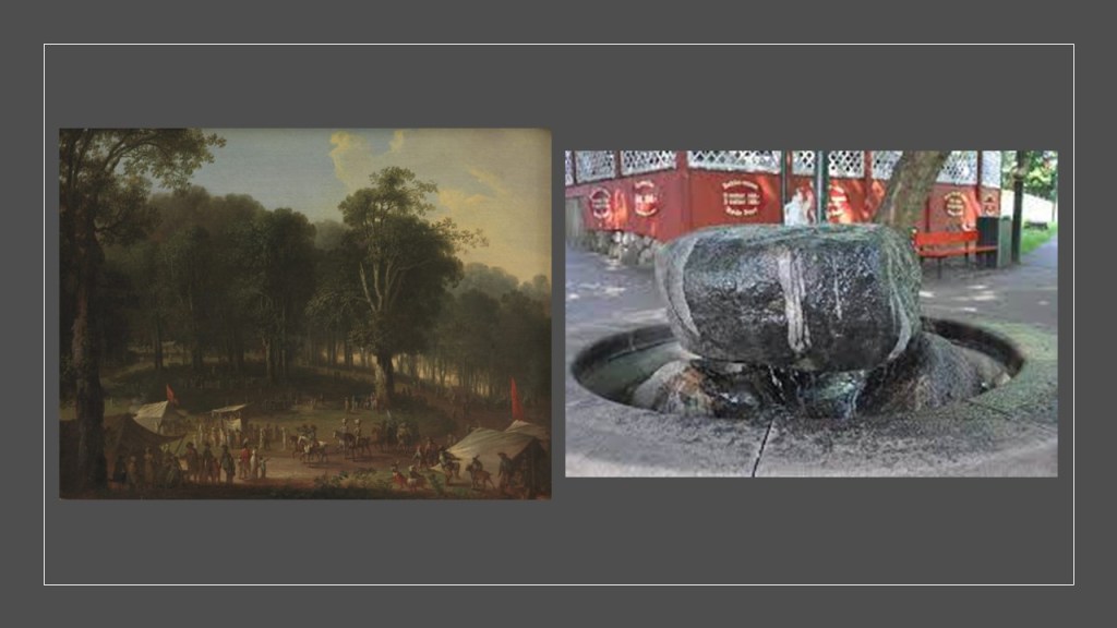
Opening 438 years ago, in the year of 1583, it is the world’s oldest operating amusement park, and the admission is free.
Its origins are related in this way: in 1583, Kristen Pill found a natural spring in a large forest park here. Residents of Copenhagen to the south of it were attracted to the spring because of the poor water quality in Copenhagen, and the belief that it had curative powers. The spring drew large crowds in the warmer months, and the large crowds attracted the entertainers and hawkers which was said to be the origin of the amusement park today.
We are told Bakken continued to grow even throughout the Napoleonic Wars, and became even more popular as time went on, with easy accessibility via steamships, starting in 1820, and railroads starting in 1864.
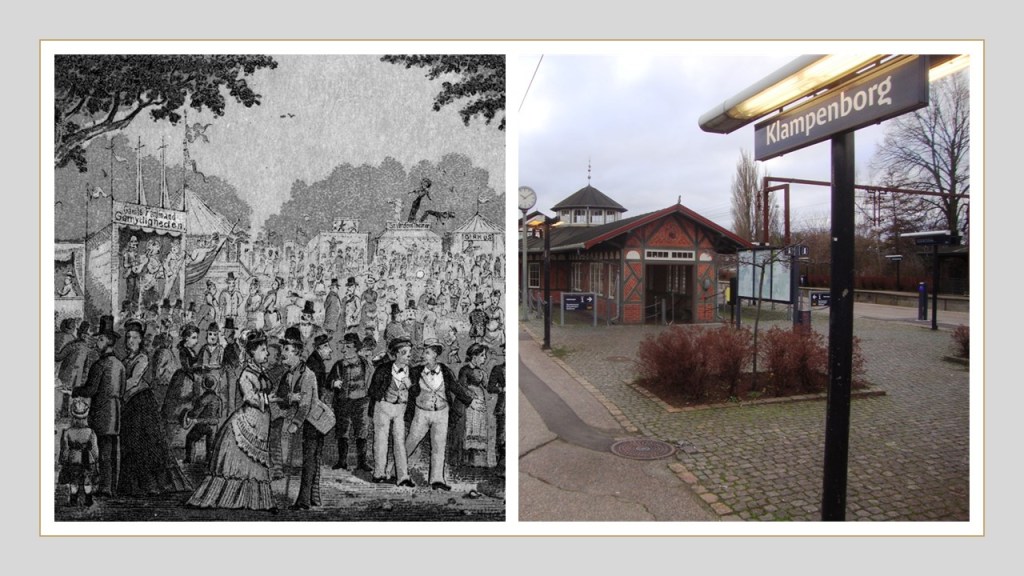
Popular cabaret entertainment opened at the park starting in 1866 with San Souci…

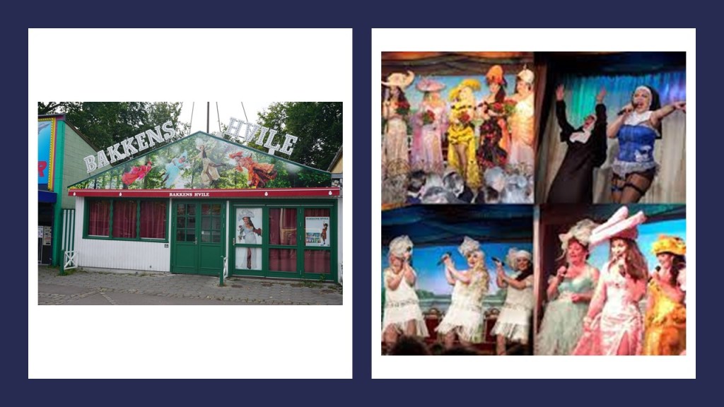
…as well as Bakkens Hvile in 1877.
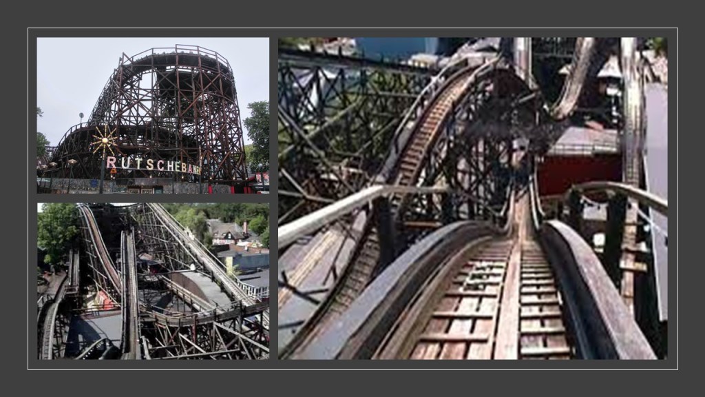
Today the park is filled with rides and amenities, including 5 roller coasters.
The park’s most famous roller coaster is the “Rutschebanen,” a wooden roller coaster that has been open since 1932.
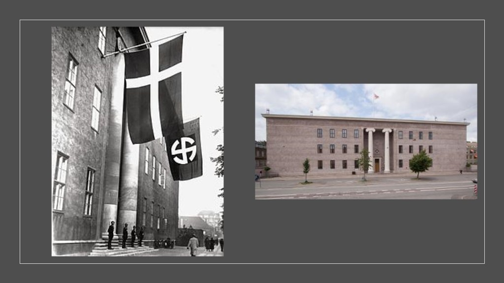
Something to keep in mind for historical perspective, during this time frame for the construction of the “Rutschebanen,” in 1932, is that Denmark was occupied by the Nazi Germans for almost the entirety of World War II, from 1940 to 1945.
The headquarters of the Danish SS Unit was the massive Danish Freemasonic Lodge in Copenhagen, said to date back to 1927, and was designed by Danish Freemason and architect Holger Rasmussen.
Now I am going to take a look at The Charlottenlund Racetrack and the Charlottenlund Fort, a short-distance to the southeast of Klampenborg.
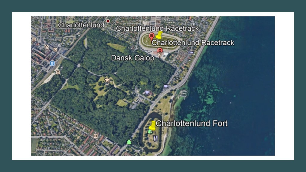
It is interesting to note that the Klampenborg Racecourse at the top-left of this Google Earth screenshot, the Charlottenlund Racetrack in the lower right-middle, and the Charlottenlund Fort on the lower right all have a similar pear-, or egg-elliptical shape.
The Charlottenlund Racetrack, also known as Lunden, is a horse harness-harness racetrack that first opened in 1891.
The two major annual events held here are the Danish Trotting Derby…
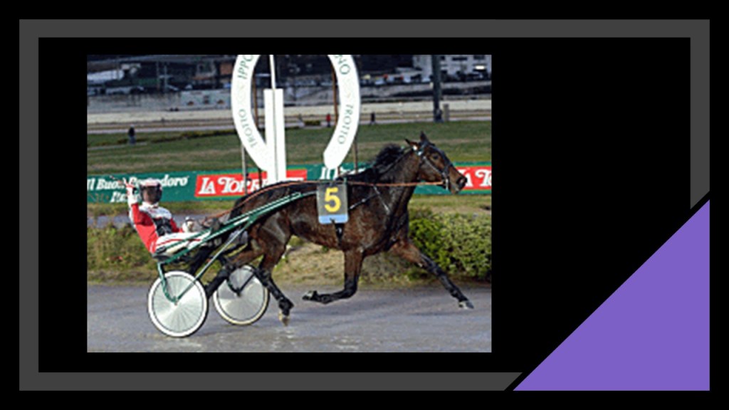
…and the Copenhagen Cup, an international Group One harness racing event that was established in 1928, and known as the International Championship until 1966.
It is held on the second-weekend in June every year.
The Charlottenlund Fort was said to have been built as part of the fortifications around Copenhagen between 1866 and 1868, and that in 1910, it was converted into a fort designed to protect Copenhagen from attacks from the sea.

It is located below Charlottenlund Palace, a former royal summer residence, with construction of it said to have started in 1731 and completed in 1881.

Now a cultural event venue, from 1935 to 2017, the Charlottenlund Palace housed the Danish Biological Station.
The railroad also goes through Charlottenlund.

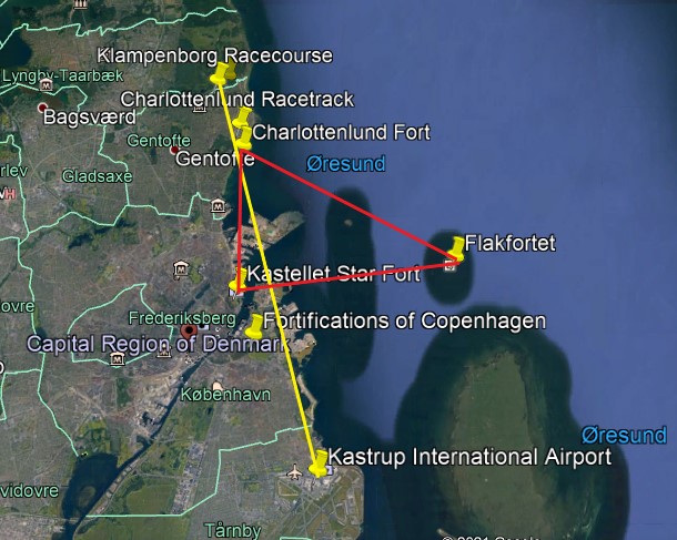
Next, I am going to look at the star forts of Kastellet and Flakfortet, the city fortifications of Copenhagen, and the Tivoli Gardens Amusement Park.
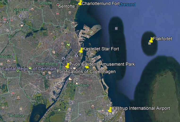
Kastellet is seen here in the top middle of the Google Earth screenshot, and across the water-channel, close to one end of the line of what are called the Copenhagen city fortifications
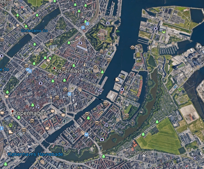
Kastellet, which translates to “The Citadel,” is considered to be one of the best fortresses in Northern Europe, and was said to have been founded by King Christian IV in 1626.
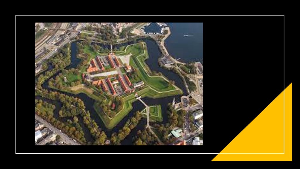
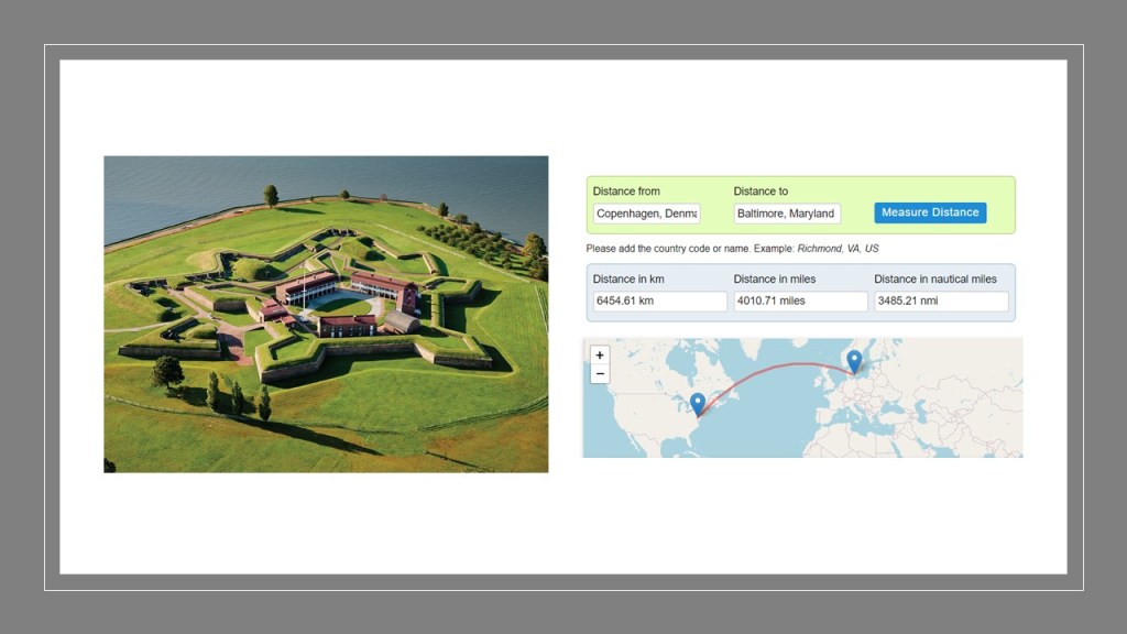
Constructed as a pentagon with bastions at its corners, it looks remarkably similar to the Castle of Good Hope in Cape Town, South Africa, on the top right, and Fort McHenry in Baltimore, Maryland, on the bottom right.

Copenhagen is a straight-line distance of 6,201-miles, or 9,799-kilometers, away from Cape Town, where the Castle of Good Hope was said to have been built by the Dutch East India Company between 1666 and 1679…

…and 4011-miles, or 6,455-kilometers, from Baltimore, where Fort McHenry was said to have been built between 1798 and 1800, and designed by the French-born military engineer Jean Foncin, with the purpose of improving the defenses of the increasingly important Port of Baltimore.
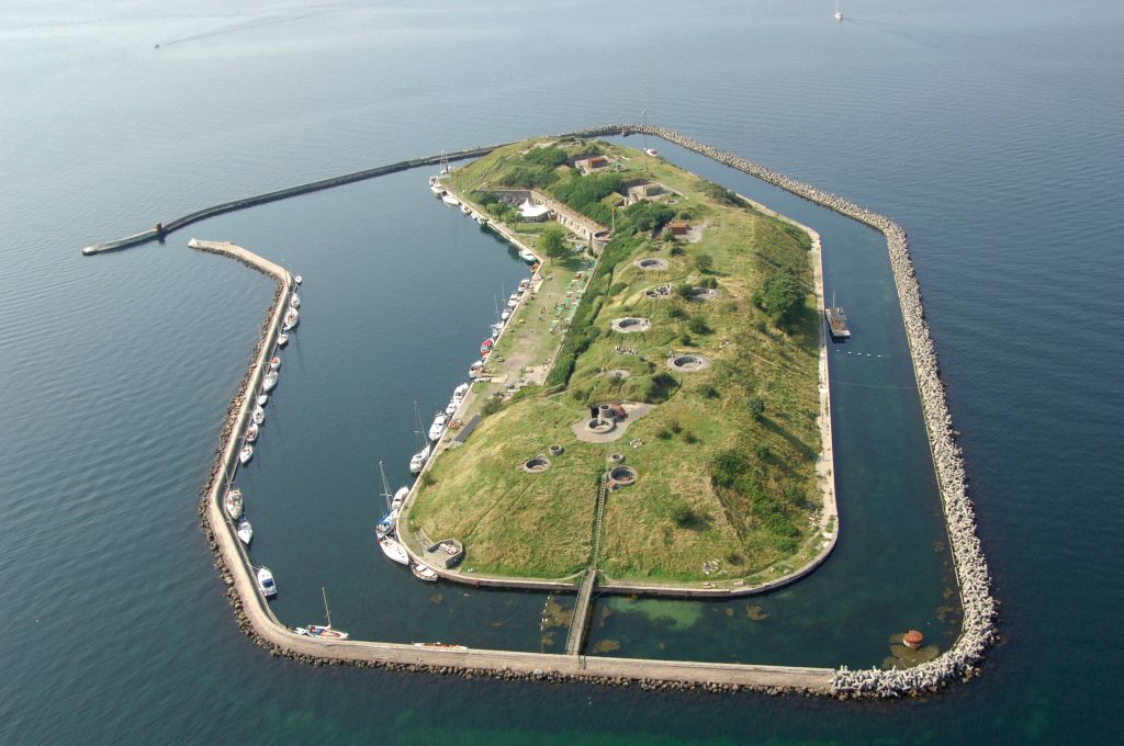
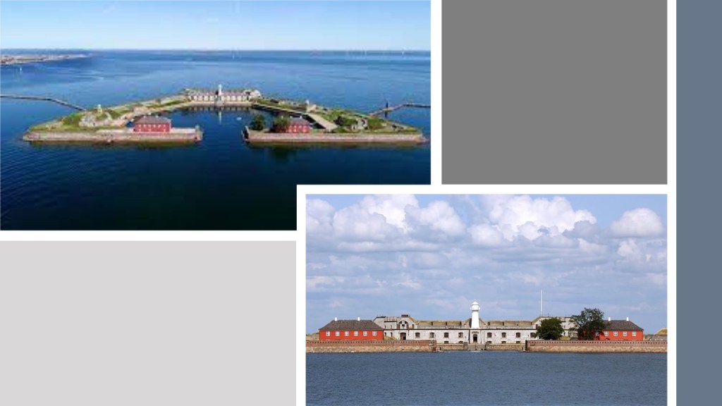
Flakfortet, meaning sand-shoal fortress, is located on Saltholmrev, an artificially-built island in the sound between Copenhagen and the Danish island of Saltholm in the body of water that separates Denmark and Sweden.
We are told that Flakfortet, said to have been built between 1910 and 1914, was the last of three artificial islands that the Danes created to defend Copenhagen Harbor.
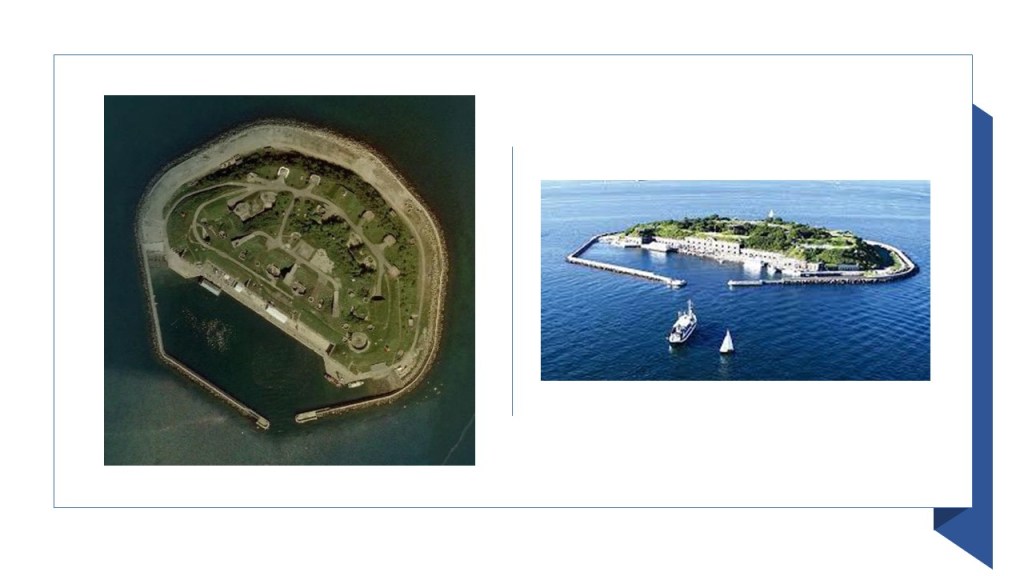
The oldest fort on an artificial island, Trekroner at the entrance of Copenhagen Harbor, was said to have been constructed starting in 1787 as part of the fortifications of Copenhagen.
The third fort, Middelgrundsfortet, is located on an artificial island, the largest in the world at one time, in the sound between Copenhagen and the city of Malmo in Sweden, and said to have been constructed by the government of King Christian IX of Denmark between 1890 and 1894 to serve as part of Copenhagen’s coastal fortifications to defend the entrance to Copenhagen’s Harbor.
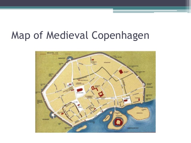
The Fortifications of Copenhagen is the general name for the rings of fortifications surrounding Copenhagen.
They are classified historically as the medieval fortifications dating from the 12th-century…
…the bastioned fortifications dating from the 17th-century, illustrated in this map circa 1728…

…and the ring fortification system said to have been built between 1886 and 1894, including a rampart complex of numerous bastions and batteries to the west of Copenhagen known as Vestvolden.

To the North of Copenhagen, five detached land forts were said to have been constructed during this time, including Garderhoj Fort, built we are told between 1886 and 1892 with private funding and subsequently leased to the Danish War Ministry.

Then between 1909 and 1916, six new coastal forts were said to have been constructed from north to south, including Mosede Fort.

Wow, no wonder the Nazi Germans occupied Denmark for five years during World War II ~ they also occupied the Channel Islands between 1940 and 1945, as Alderney and the other Channel Islands were loaded with star forts as well!
Here is a comparison between the appearance of the Fortifications of Copenhagen on the left and Valletta, the capital city of the island Republic of Malta, on the right…

…and the location relative to each other and the straight-line distance between Copenhagen and Malta.
The Tivoli Gardens Amusement Park in Copenhagen opened in 1843, making it the third-oldest operating amusement park in the world, after Bakken in Klampenborg, and the Wurstelprater in Vienna, Austria, which opened to the public in 1766.
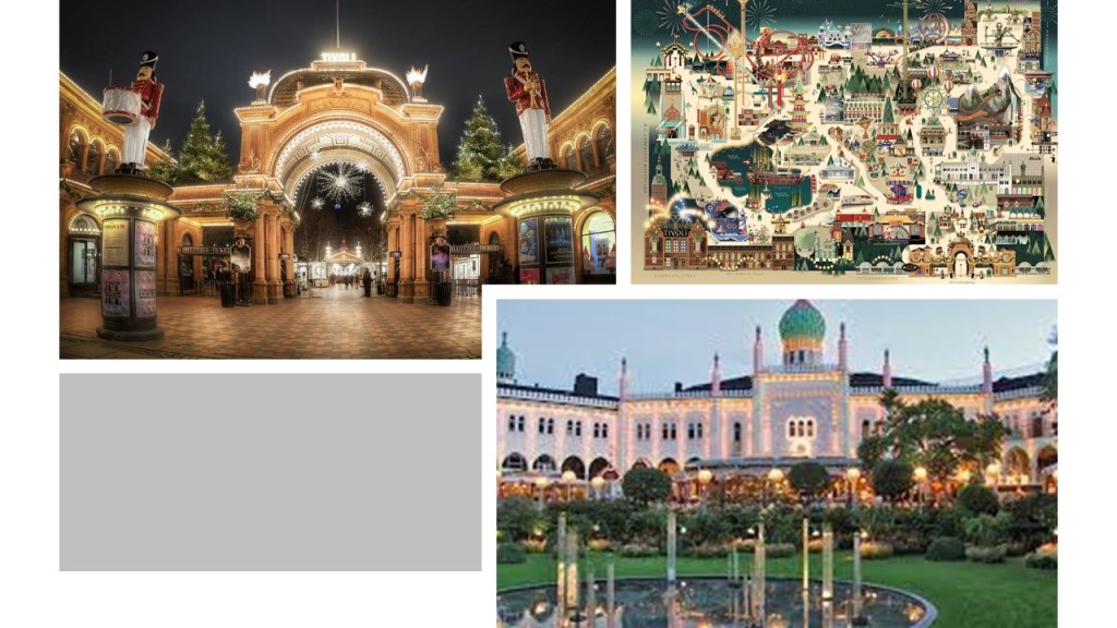
It is located in downtown Copenhagen next to the Central Rail Station…
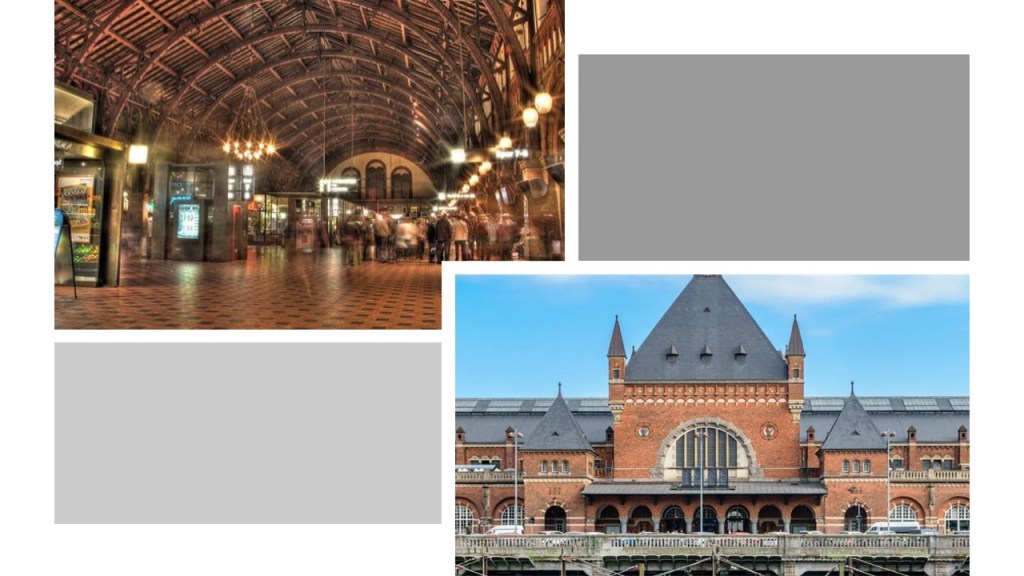
…and the railyards there.

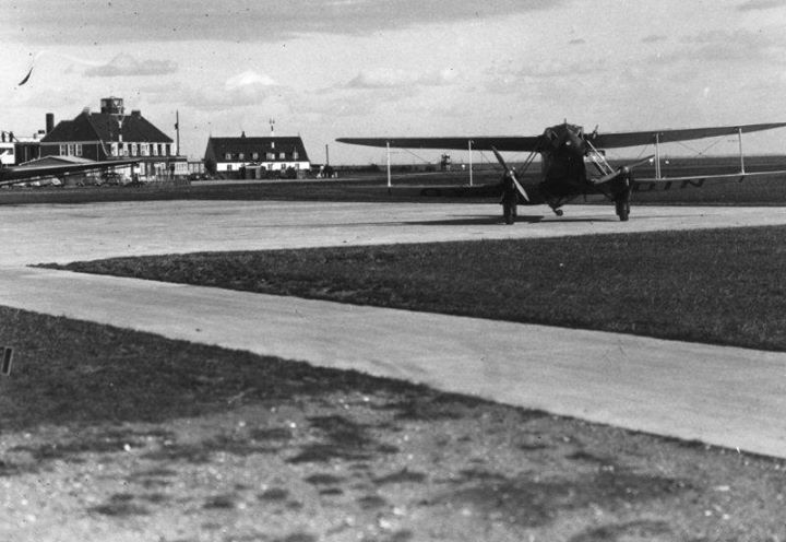
The Copenhagen Airport at Kastrup is the main international airport serving the region, and the largest airport in the Nordic countries.
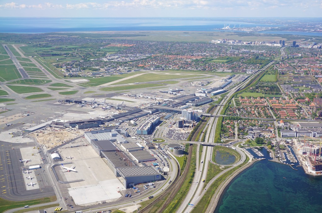
One of the oldest international airports in Europe, it was said to have been inaugurated in 1925 and one of the first civil airports in the world.
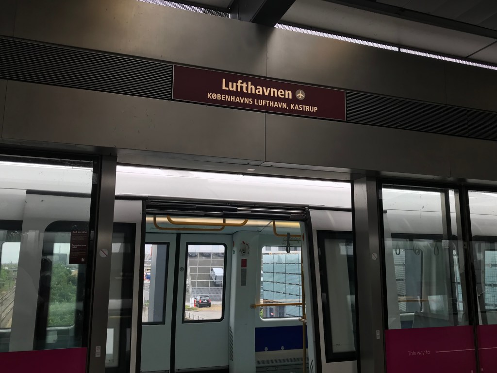
There is a train station under Terminal 3 of the Oresund Railway line…

…and the airport is also connected by subway Line M2 of the Copenhagen Metro, which links the airport with the city center in about 15 minutes.
More on all of these infrastructure interconnections between everything throughout this post, but I believe this was all intentional infrastructure built by the original ancient advanced Moorish civilization that is missing from our collective awareness, and all part of the earth’s worldwide electromagnetic, free-energy-generating, grid system.
Before I leave Copenhagen, I just want to share what I found in our historical narrative about its history in previous research.
We are told that the Union of the Kingdom of Denmark-Norway, also known as the Oldenburg Monarchy, existed between 1537 AD and 1814 AD.
Apparently, the Oldenburg Monarchy had long-remained neutral in the Napoleonic Wars.
Britain was said to have feared that Napoleon would attempt to conquer the Danish-Norwegian naval fleet, and used that as a pretext to attack Copenhagen in what became known as the Siege of Copenhagen in August of 1807, and Britain seized the naval fleet in September of 1807.
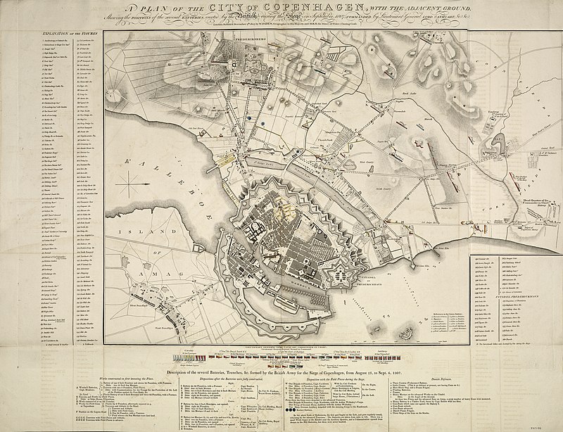
This also assured the use of the sea lanes in the North Sea and Baltic Sea for the British merchant fleet.
The “fleet robbery” drew Denmark-Norway into the war on the side of Napoleon.
Then in 1814, during the Napoleonic Wars, the Treaty of Kiel, between the United Kingdom and Sweden on the anti-French-side, and Norway and Denmark on the French-side, dissolved the Oldenburg Monarchy by transferring Norway to the King of Sweden.

The King of Denmark retained the Faroe Islands, Greenland, and Iceland.
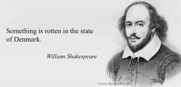
See how that works?
Something along the lines of “Something is rotten in the state of Denmark,” a modern saying which originated from Shakespeare’s play “Hamlet.”
Another viewer left the comment “Check out the Toledo speedway, right next to two large freight yards and a former trolley park which is now a giant ditch.”
This is what I found on Google Earth relate to Toledo Airports and race tracks.

The yellow lines connect airports with race tracks.
The red lines form a triangle between race tracks, and the blue lines from a triangle between the two airports and other race tracks.
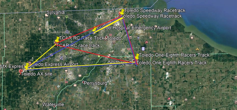
I located the railyards slightly south of the Toledo Speedway Racetrack, and the best candidate for the former trolley park in the vicinity would be the Willow Beach Amusement Park, where Cullen Park is today.
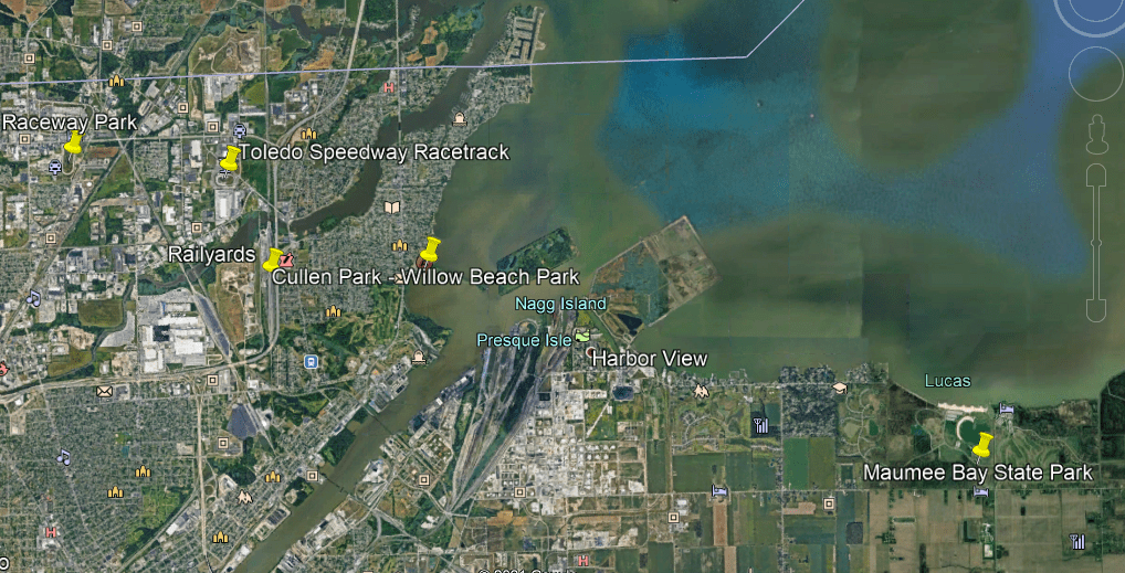
The Willow Beach Park, which opened in 1929, was a haven for food, games, gambling rides and entertainment at what was known as Point Place at the time.
Setbacks to the park were said to have included the October 1929 stock market crash just months after the park opened in June of 1929…

…a fire in 1932, and permanent park closure in 1947 due to a death on one of the rides.

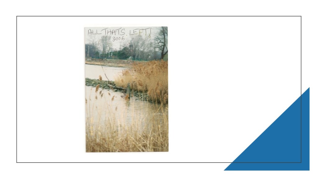
This photo was taken by someone in 2006 to show what remains of the original amusement park today.
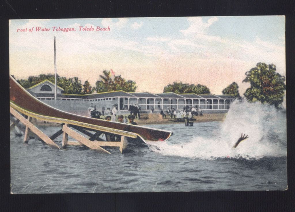
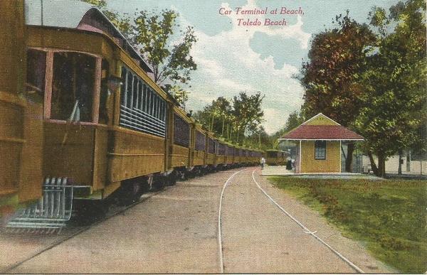
There was another historic amusement park just a short ways up the coast of Lake Erie from Toledo in Ohio, called Toledo Beach.
It was located where the Toledo Beach Marina is today.
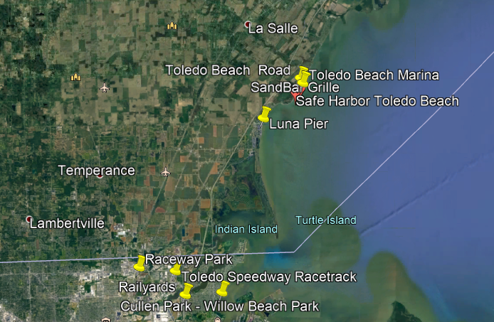
The Toledo Light Rail and Power Company bought the Ottawa Beach Resort in 1907, and created the Toledo Beach Amusement Park, and an electric trolley service brought visitors from Ohio into the park.
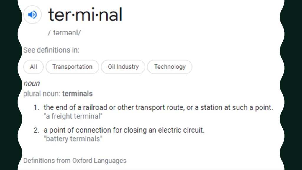
The trolley also made stops at Lakeside, Lakewood, Allen’s Cove, and Luna Pier along the way to Toledo Beach, the end, also known as terminal, of the streetcar line.

There are two definitions of terminal.
One is: “The end of a railroad or other transport route, or a station at such a point.”
The other is: “A point of connection for closing an electric circuit.”
We are told that the peak of the popularity of the Toledo Beach Park was in the early 1900s, and that attendance slowly declined after the electric interurban trolleys stopped running in 1927.
…and that the park had its ups-and-downs over the years, having been shut down during hard economic times, until the amusement park was purchased in 1961 for the land on which the buyer wanted to build a marina.

The Toledo Beach Amusement park was dredged, and the Toledo Park Marina was built and opened in 1962.
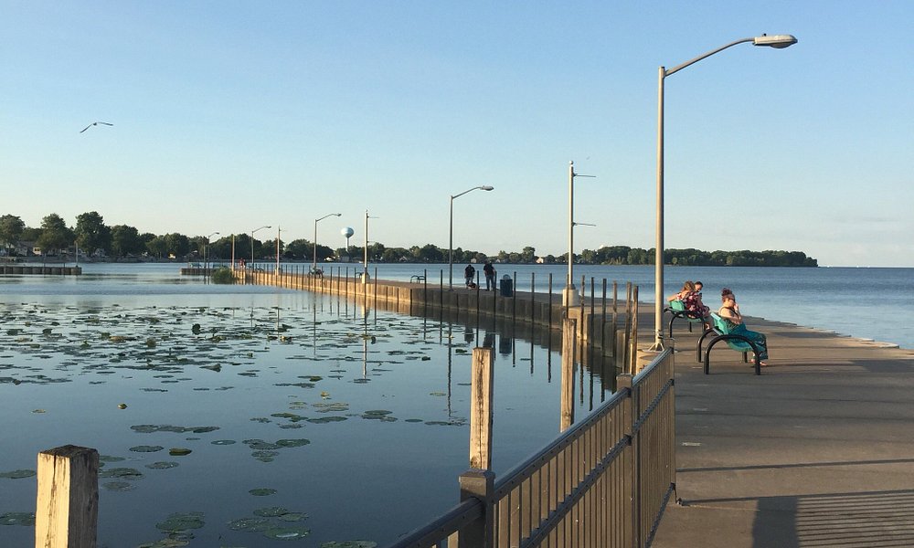
Luna Pier and its surrounding community was located Just below Toledo Beach in Michigan, 6-miles, or 10-kilometers, north of Toledo, Ohio.
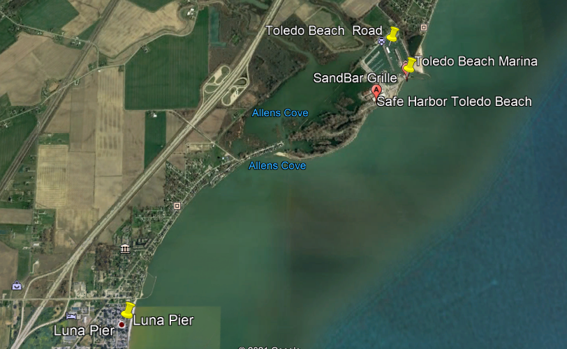
Luna Pier has a crescent-shaped concrete pier that extends for 800-feet, or 240-meters, reaching about 200-feet, or 61-meters, into Lake Erie.
Luna Pier used to be served by the Canadian National Railway via coal trains that served the J. R. Whiting Generating Plant, which closed in April of 2016 and which has since been demolished.
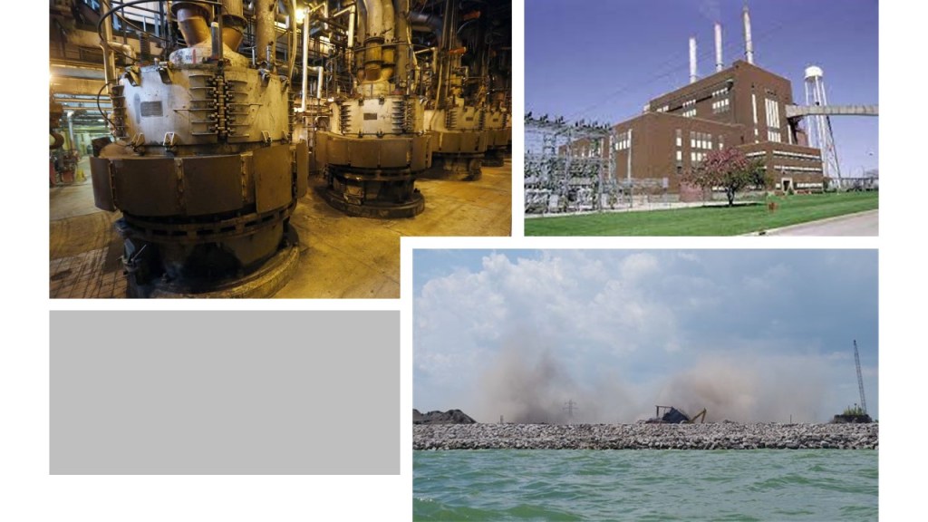
The J. R. Whiting Generating Plant first opened in 1952, so it was only in use for 64-years.
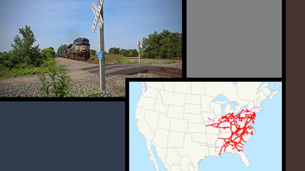
The freight-carrying Norfolk Southern Railway also has railroad tracks through the area, but doesn’t serve any industries.
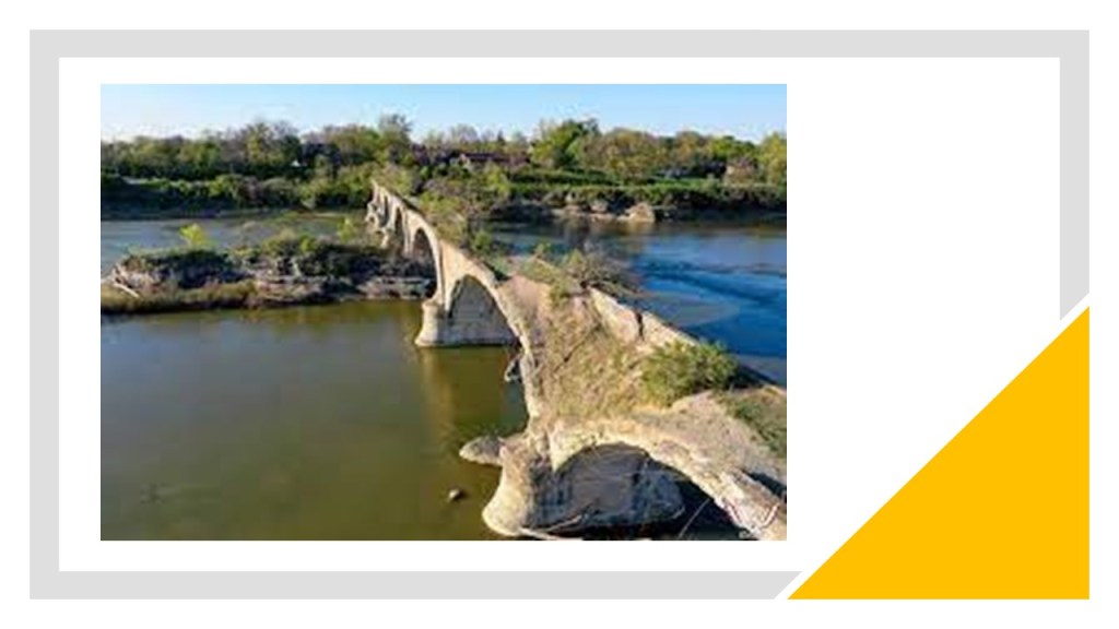
The viewer that commented about Toledo also wrote this: “I’ve also wondered what your thoughts might be on the Roche de Boeuf and abandoned Interurban Bridge on the Maumee river. This bridge was part of the lake shore line that went to Cleveland.”
He was referring to the Interurban bridge of Waterville, Ohio,which is an historic, concrete, multi-arch bridge, that was said to have been built in 1908 to connect Lucas and Wood counties across the Maumee river.

We are told that at the time of its construction, and for some time thereafter, it was the world’s largest earth-filled, reinforced concrete bridge, and that the decision was made in its construction to rest one of its supports on the historic indian council rock known as Roche de Boeuf near the center of the Maumee river, but that unfortunately during its construction the rock was partially destroyed.

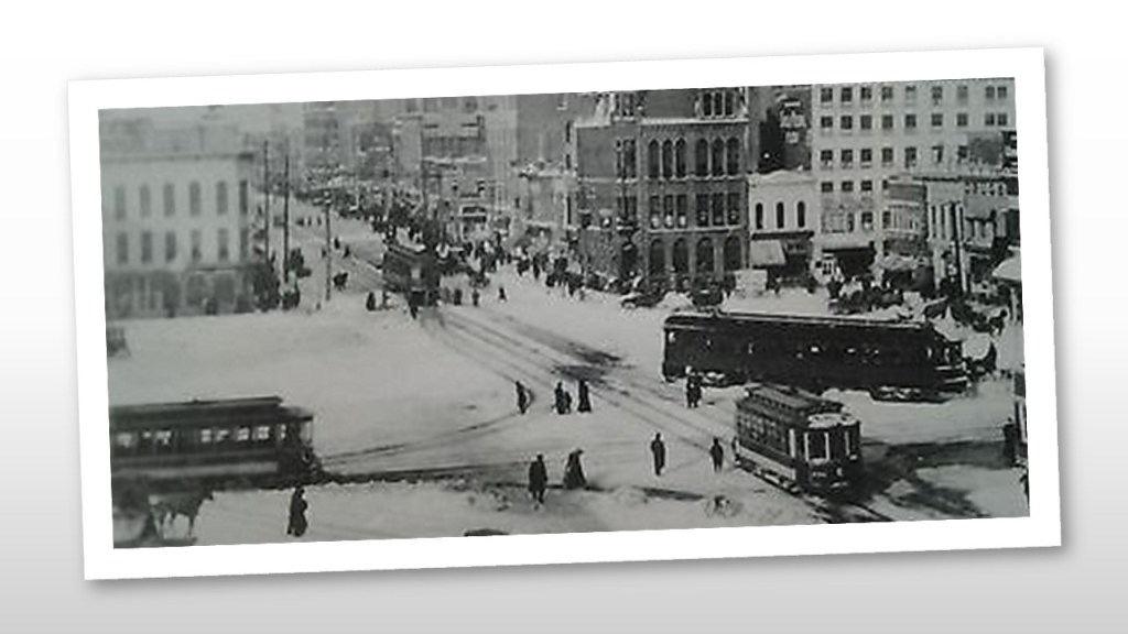
Interurbans were a type of electric railway with self-propelled rail-cars running between cities or towns in North America and Europe. They were prevalent in North America starting in 1900, and by 1915, interurban railways in the United States were operating along, 15,500-miles, or 24,900-kilometers of track.
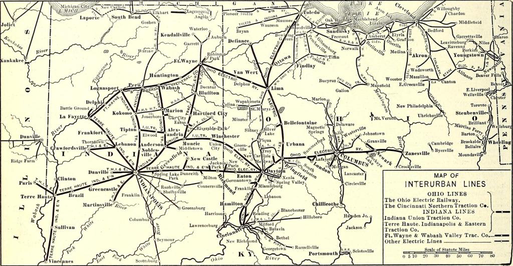
By 1930, however, most of the interurbans were gone, with a few surviving into the 1950s.
The Lima-Toledo Railroad would combine with two other Ohio interurbans in 1929– the Cincinnati Hamilton and Dayton, and the Indiana, Columbus and Eastern. This merge formed the 323-mile-long Cincinnati and Lake Erie Railroad, providing service from Toledo to Cincinnati.
Then the Great Depression hit the Cincinnati and Lake Erie Railroad hard; this would soon bring an early end to operations. With a collapsing national and local economy throughout the 1930s, things were headed for the worst.
It was seen as far more convenient, and cost-efficient to carry cargo by way of truck and other automobiles.
So by 1937, only 29 years after beginning operation, C&LE was no more, and the bridge has sat unused to this day.
What are my thoughts?
The Maumee River Interurban bridge looks way older than 113-years-old.
And why build a sophisticated, self-propelled electric street-car system, only to use it for 29-years and replace it trucks and cars?
Well, the most obvious answer is that the mass production of gasoline-powered private and public transportation provided another form of transportation for people and provided a highly lucrative means of generating wealth for the big corporations involved in the transportation industry.

Non-polluting and low-fare electric-streetcar-systems were simply no longer needed or wanted.
Another viewer commented about Pittsburgh, saying there is an alignment from the downtown professional football and baseball sports fields, through Pittsburgh International Airport, to the Mountaineer Racetrack & Casino, on the Ohio River across the state line in West Virginia.
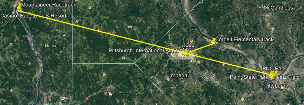
In addition to the indicated linear alignment, I located an ellipse in the same northeast relationship to the Pittsburgh International Airport that I have been finding in many other places…this time the ellipse is the track at the Cornell Elementary School in Coraopolis.

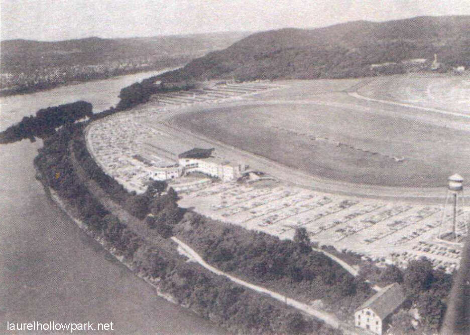
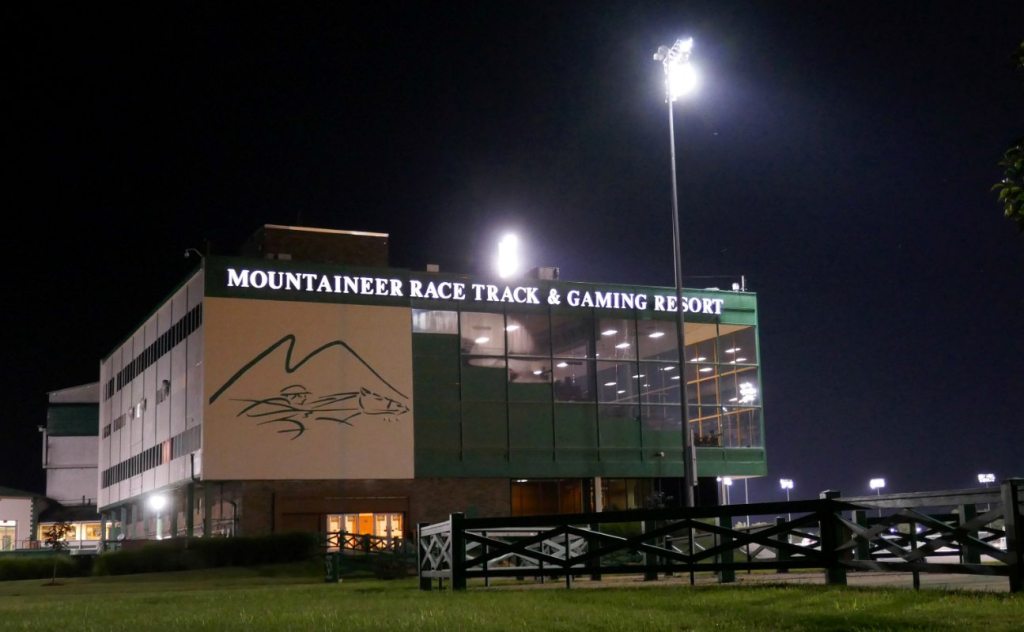
What is now the Mountaineer Racetrack and Casino was originally called Waterford Park, and constructed in New Cumberland, West Virginia after delays since 1939, starting in July of 1948, and opening day was finally held on May 19th of 1951.
The thoroughbred horse-race track was purchased in 1987 by Bill Blair, and he renamed it Mountaineer Park.
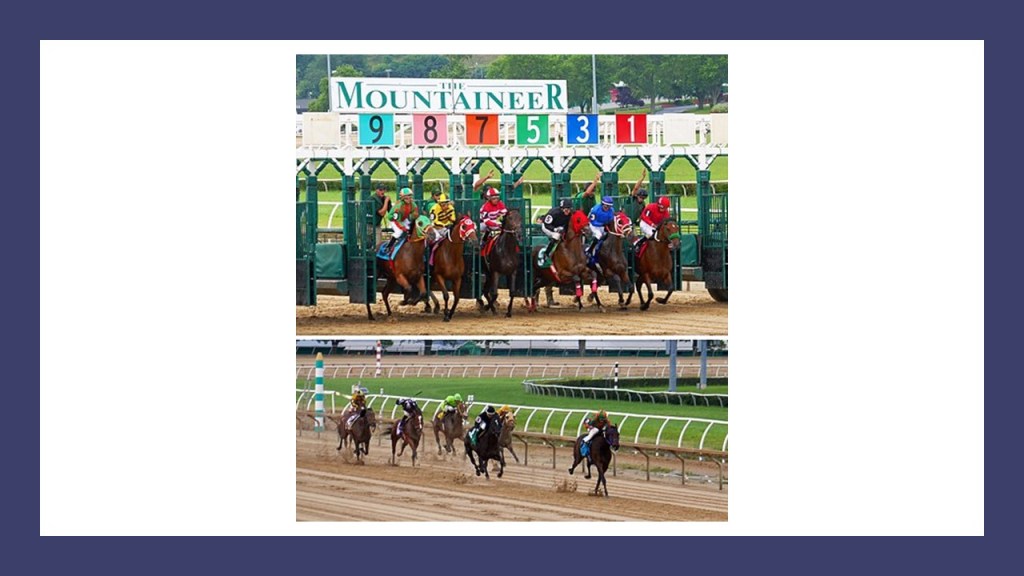
He sold it to a California-based company in 1992 for $4-million in cash, and $2.7-million in stock, at which time slot machines were added, and casino game tables were added later.
In 2019, Century Casinos bought Mountaineers operating business for $30 million, and Vici Properties bought the land and buildings for $97 million and leased them to Century.
Seems to be a pretty lucrative business to be involved in….
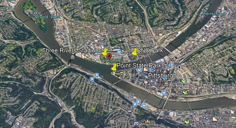
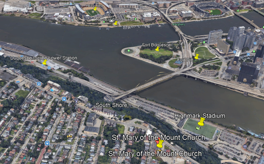
Back in downtown Pittsburgh, Heinz Field, the home of the NFL Steelers, and PNC Park, home of the MLB Pirates, are located right at the Forks of the Ohio, where the Ohio River forks into the Allegheny River flowing towards the North, and the Monongehela River flowing to the South.
These two major league sports’ stadiums are right across the mouth of the Allegheny River from Point State Park, the historic location of two star forts – Fort Pitt and Fort Duquesne right at the Forks of the Ohio.
Another point of interest at this location that was brought to my attention by another commenter was the “Tribute to Children,” a statue of Fred Rogers of Mr. Rogers’ Neighborhood fame, that was unveiled in November of 2009 in front of an archway in Roberto Clemente Park on the shoreline directly in front of Heinz Field.
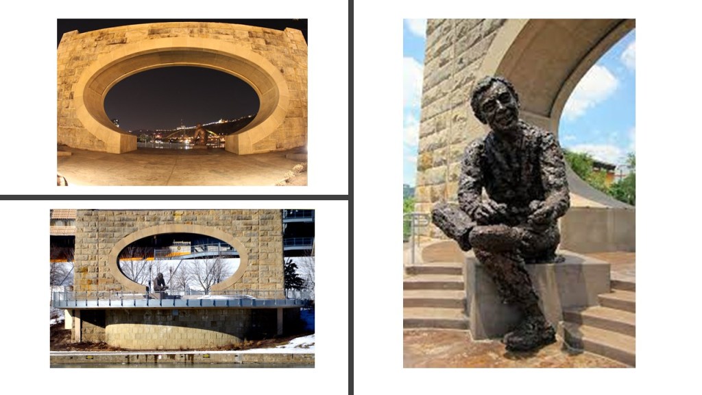
From the information she provided on the arch, when I looked at the points on Google Earth, I found an alignment from Heinz Field, through the “Tribute to Children” Arch, to at least Fort Duquesne, and I continued the alignment out across the Monongahela River, through a section of the river that would require a high amount of electricity generation…
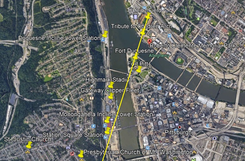
…to power Pittsburgh’s two remaining incline railways, out of what was originally seventeen in Pittsburgh, on Mount Washington, named the Duquesne and Monongahela Inclines…

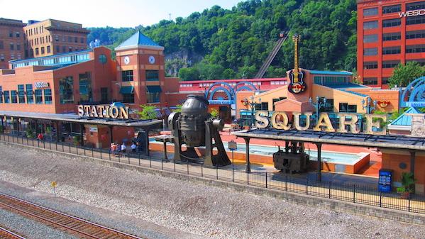
…as well as the Station Square Station, a transit station on the Port Authority of Allegheny County’s Light Rail network, and the last transit station on the south side of the Monongahela River.

In addition in to the high-electricity needed location on the south-side of the Monongahela River, I found the Highmark Stadium near the alignment, a soccer, lacrosse and rugby stadium in Pittsburgh’s Station Square, and home of professional soccer’s Pittsburgh Riverhounds team…

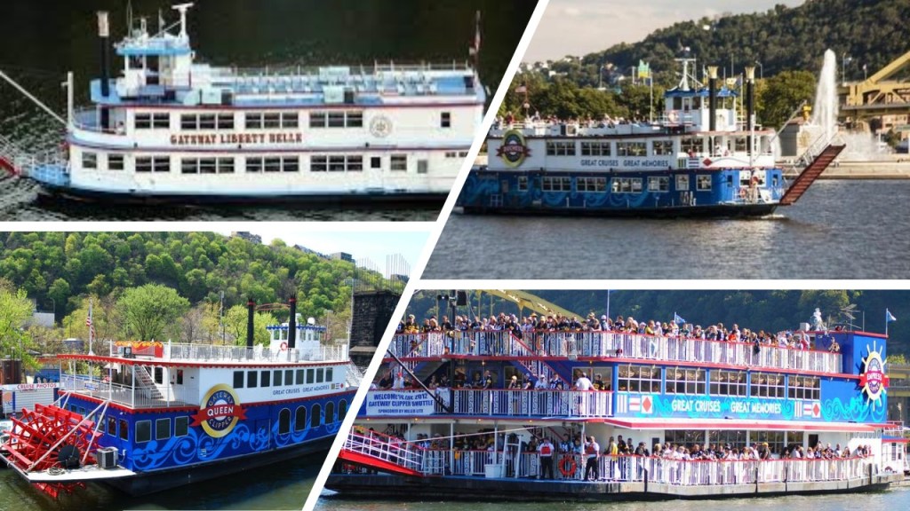
…the Gateway Clipper Fleet, a fleet of riverboats that cruise the Three Rivers, and named after Pittsburgh’s nickname of “Gateway to the West.” Since the 1980s, the fleet has been moored at Station Square, where the dock and loading Bay are located.
Station Square is now an indoor and outdoor shopping and entertainment complex on lands formerly occupied by the historic Pittsburgh and Lake Erie Railroad Station, and across the Monongahela River from Pittsburgh’s Golden Triangle of downtown Pittsburgh.
Is it me seeing things, or is that a statue of R2D2 at the entrance to Station Square?
I can’t find a confirmation that it is R2D2 for sure, but its likeness stands out in my mind because of a configuration of the blueprint for the lay-out of the Franco-British Exhibition and the White City Stadium that reminded me of R2D2 that I mentioned in the first part of this series.

Further up, the Presbyterian Church of Mt. Washington, or Grand View United Presbyterian Church, is located near the alignment with Heinz Field, the “Tribute to Children” Arch and Fort Duquesne.

Just a thought, could Mt. Washington be a very large, flat-topped pyramid/earthwork, given the 30-degree angle of the Duquesne Incline on the right, compared with the similar angle in the diagram of a flat-topped pyramid on the left…
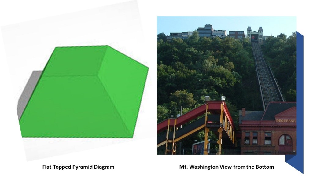
…and the relatively flat, uniform surface of the top of Mt. Washington.
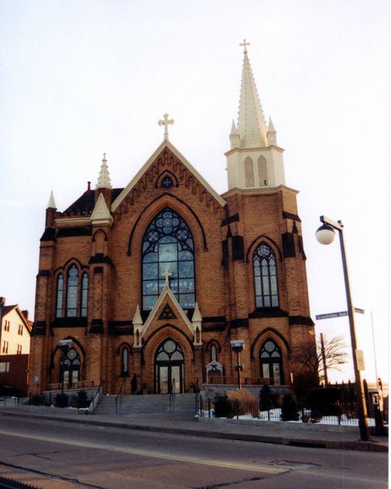
The St. Mary of the Mount Catholic Church on top of Mt. Washington is situated right next to the edge at the top, overlooking the places we have been looking at below…
…with a mud-flooded appearance signified by the slanted street in front of it, and some beautiful cathedral windows…
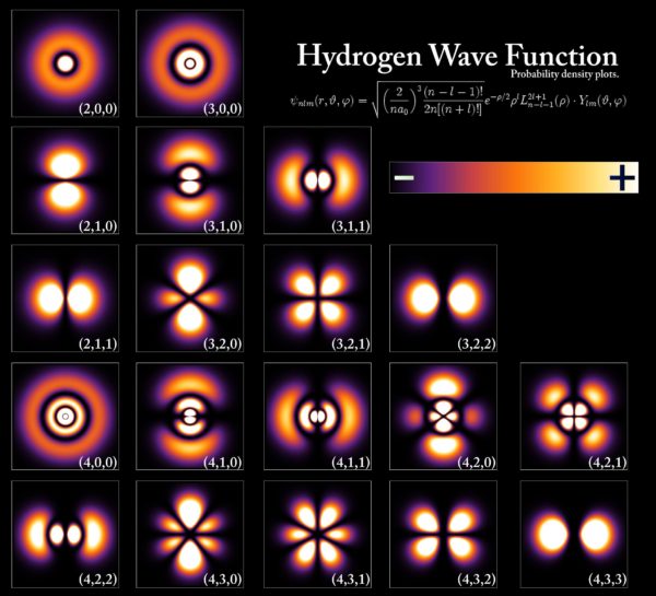
…which also resemble in appearance the patterns of some hydrogen wave functions. Could there be a connection somehow between cathedral windows and atomic wave functions?

This chart shows the orbitals of the electron an a hydrogen atom at different energy levels, and represent the basic-building blocks of the atomic orbital model, in this example, in hydrogen-like atomic orbitals, which is a modern framework for visualizing the submicroscopic behavior of electrons in matter.
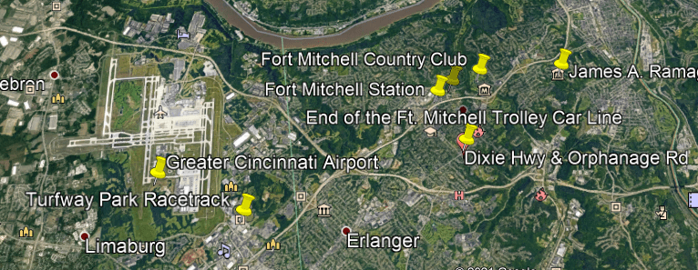
In a different region of the country, another commenter mentioned that Turfway Park is slightly southeast of the Greater Cincinnati Airport in northern Kentucky, along the south-side of the Ohio River, Kentucky’s shared border with Ohio, and part of the Greater Cincinnati Metropolitan Area.

Turfway Park is an American horse-racing track that conducts live Thoroughbred horse racing in two meets a year – in December and between January to late-March, early-April – as well as offering year-round simulcast wagering from tracks around the country.

It first opened in 1959 as Latonia Race Course, and changed its name to Turfway in 1986.
The original Latonia Race Course was located 10-miles north of the current race course, in Covington, Kentucky, and was home to the important Latonia Derby for many years, which rivalled the Kentucky Derby in prestige.
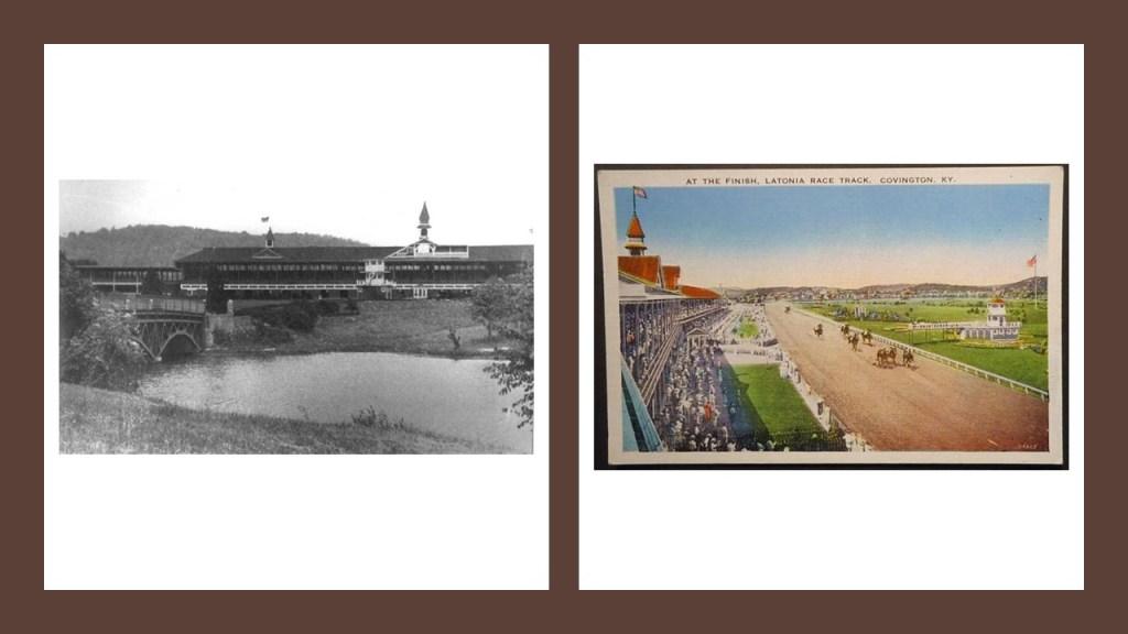
It first opened in 1883, and it closed in July of 1939. It was sold to Standard Oil of Ohio, and dismantled during World War II.
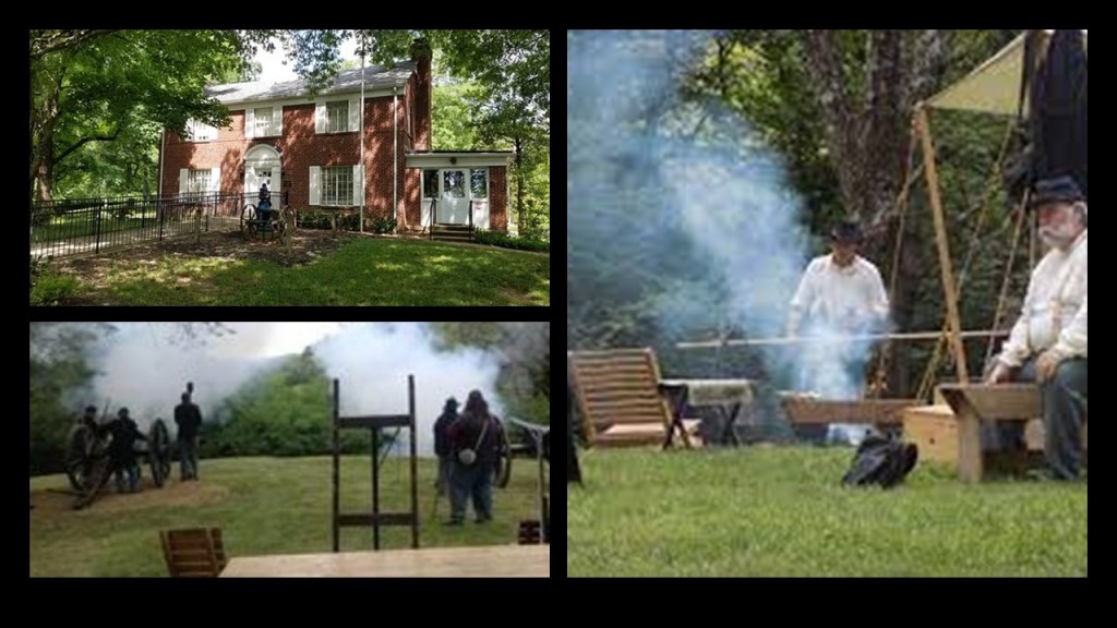
I noticed Fort Mitchell, Fort Wright, and Fort Thomas located between the Greater Cincinnati Airport on the Kentucky side of the Ohio River, and the Lunken Airport northeast of Fort Thomas on the Ohio side of the river.
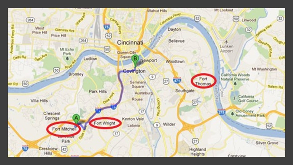
Fort Mitchell and Fort Wright were said to be two of seven Civil War fortifications built for the Defense of Cincinnati, and the U. S. Army post of Fort Thomas was said to have been built in 1890.
The Defense of Cincinnati was said to have occurred during what was called the Kentucky Campaign of the Civil War from September 1st through September 13th of 1862, when Cincinnati was threatened by Confederate forces, which at that time was the 6th-largest city in the United States.

Then when Confederate Brigadier General Henry Heth arrived with his troops from Lexington, Kentucky, reconnaissance scouts assessed the defenses, and the general determined that a major attack was pointless. After skirmishing a few days with Ohio infantry units near Fort Mitchell, the Confederate troops withdrew back to Lexington.
The town of Fort Mitchell was named for General Ormsby M. Mitchel, an astronomy and mathematics professor-turned-Civil-War-General at Cincinnati College who was said to have designed the fortification there.

Here are a few things I could find in and about Fort Mitchell.

I think General Ormsby Mitchel Park, located at the street address of 279 Grandview Drive, is the likeliest candidate for the original earthwork fortification, since I can’t find a state park or historic site designated to preserve Fort Mitchell.

Fort Mitchell Station, located at 2220 Grandview, is now a business center…
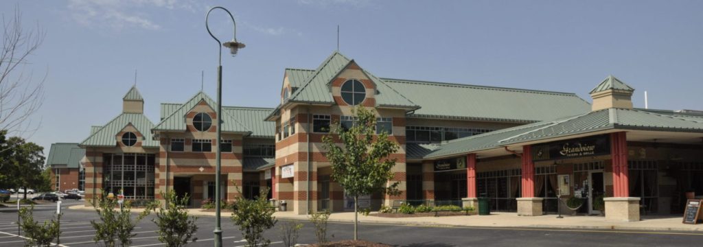
…and even though I can’t find information on-line about what it was before, it stands to reason that since it named “Station,” and is right next to a rail-line, that it was originally a railway station.

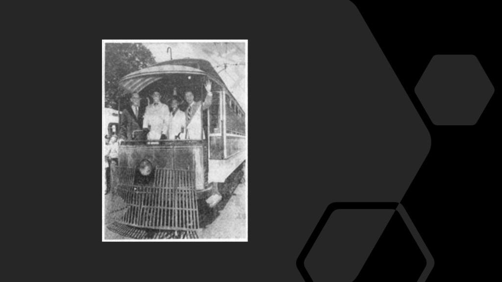
As a matter of fact, Fort Mitchell has a history of having a street-car line.
Burdsall Avenue in Fort Mitchell was a stop on the line…
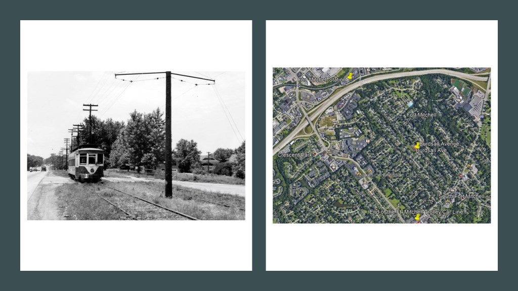
…and the end of the trolley line was at Orphanage Road and Dixie. If there was ever a trolley park here, I can’t find any record of one.
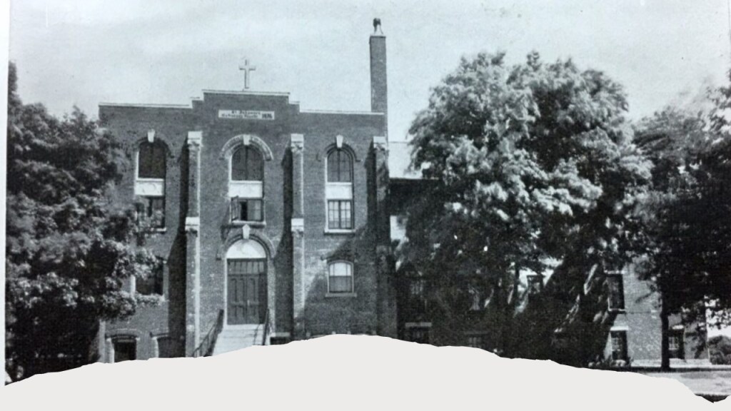
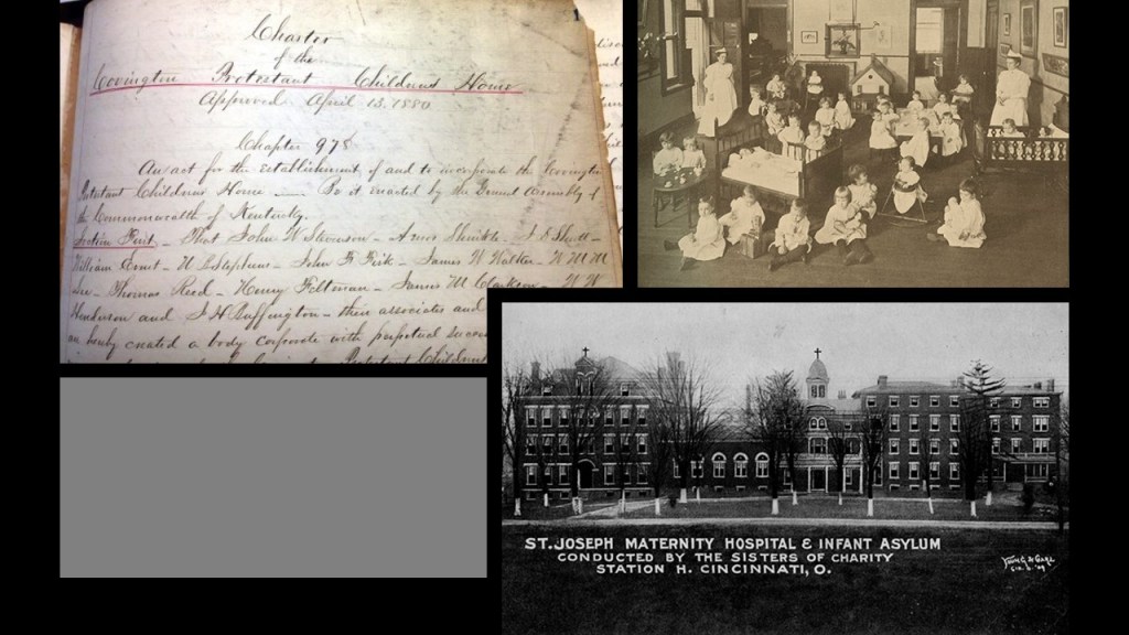
The St. John’s Orphanage in Fort Mitchell was the first orphanage in the region, with the German-Catholic founding society first meeting to organize it in June of 1848 to establish a home for Catholic orphans in Kenton County, and by January of 1868, the building and property for the orphanage was purchased on what is now the Dixie Highway. It was run by the Sisters of Notre Dame Academy.
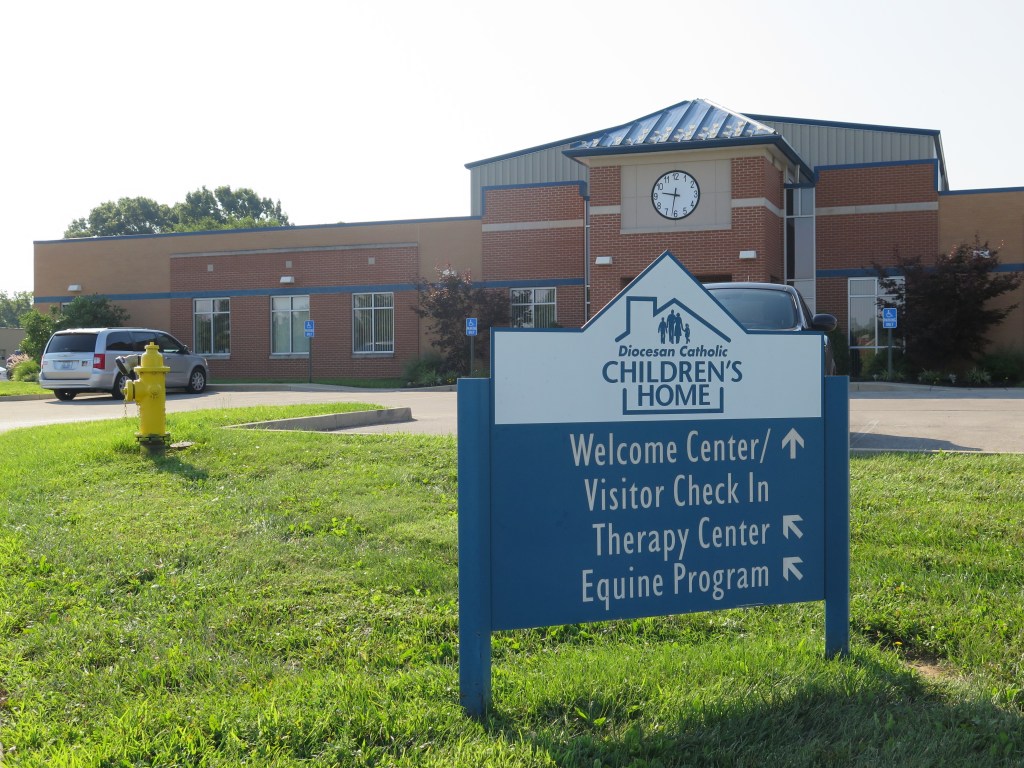
There is still a Catholic orphanage in Fort Mitchell today, known as the Diocesan Catholic Children’s Home.
I am still curious about why there were so many orphanages popping up everywhere during the 19th-century.
In a quick look at the next fort over, Fort Wright, I am finding the James A. Ramage Civil War Museum, situated on the visible earthworks seen in the Google Earth Screenshot of it on the top left, and an aerial photograph on the bottom right.
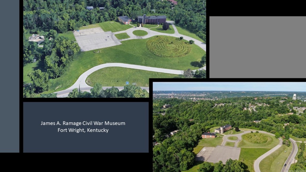
Come to find out this was the location of what was called the “Hooper Battery” at the time the Defense of Cincinnati in September of 1862.
The James A. Ramage Civil War Museum seeks to tell the untold story of Cincinnati and Northern Kentucky’s involvement in the American Civil War.
Like Fort Mitchell, Fort Wright and the whole south-side of the Ohio River was home to a large share of the 222-miles, or 357-kilometers, of streetcar tracks in the region, with the system tied to the Cincinnati Streetcar system via the Roebling, Central and L & N bridges crossing the Ohio River.
The last day of the original streetcar system in northern Kentucky was July 2nd of 1950, when the system was replaced by buses, with the promise of additional service and modern comforts.
Fort Thomas was said to have been established as a U. S. Army Depot in 1890.
Remnants of the 1890 fort are said to include the Fort Thomas Water Tower…
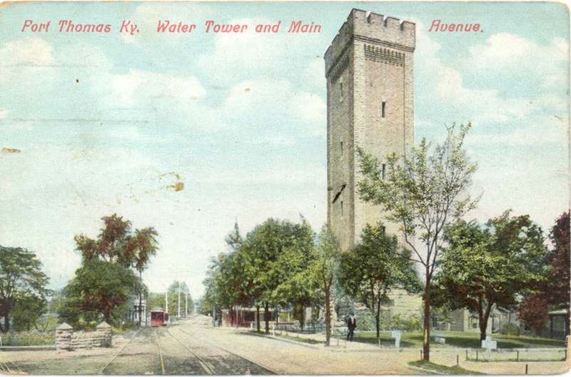
…which still stands at the entrance to Tower Park today…
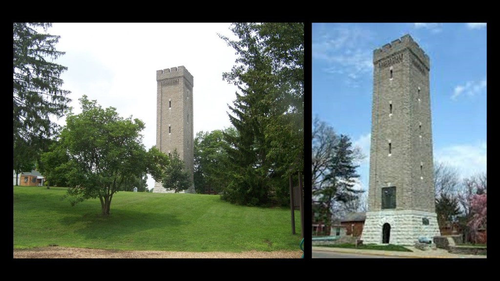
…and at one time enclosed a stand-pipe with a 100,000 gallon capacity, pumped from the Water District reservoirs just across South Fort Thomas Avenue.

Tower Park in Fort Roberts, which also has an athletic track and field on the grounds, is a short-distance southwest of Lunken Field, also known as the Cincinnati Municipal Airport.
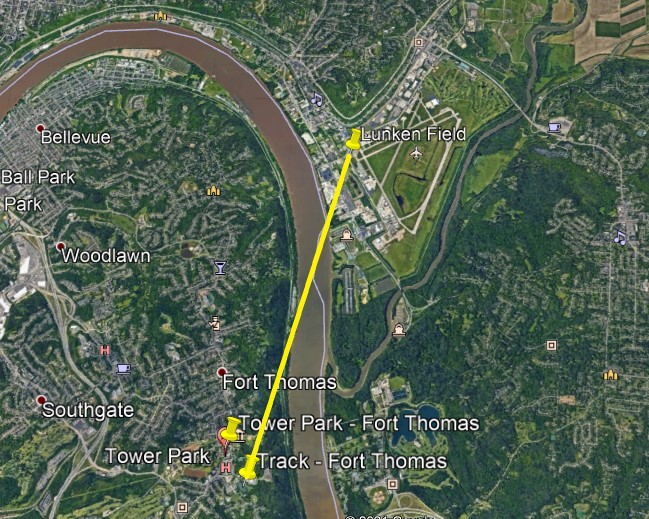
Just around the river-bend, west of Lunken Field, next to the river in downtown Cincinnati, are the city’s professional sports stadiums.
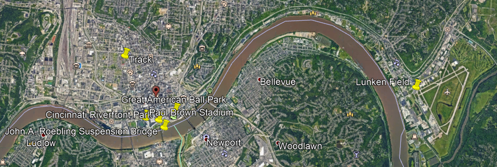
And interestingly, they are situated on the river exactly like they are in Pittsburgh.
The Paul Brown Stadium, home of the NFL Bengals, is on the left riverfront; the Great American Ball Park, home of the MLB Reds on the right riverfront.
There is a park directly in front of the Paul Brown Stadium, known as the Cincinnati Riverfront Park, like the Roberto Clemente Park in front of the Heinz Field Stadium; and a bridge located between both sporting venues.
Is the identical configuration only a coincidence?

The John A. Roebling Bridge is located between the two stadiums, spanning the Ohio River between Cincinnati and Covington, Kentucky.
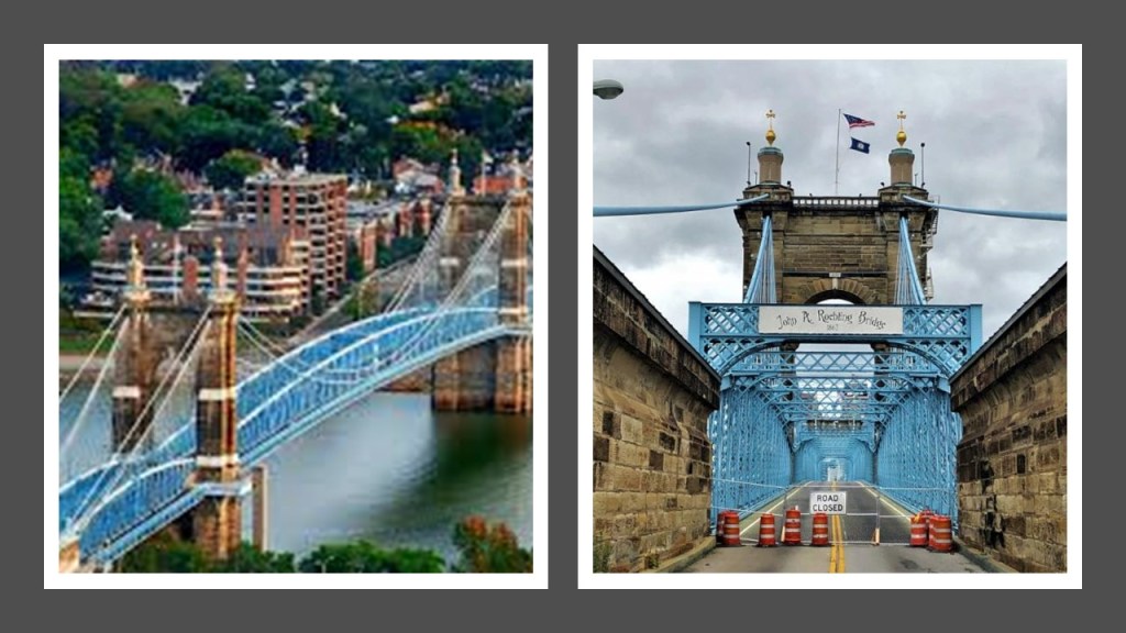
We are told it first opened on December 1st of 1866, which would have been a year after the end of the American Civil War, and at the time the bridge, it was the longest suspension bridge in the world.
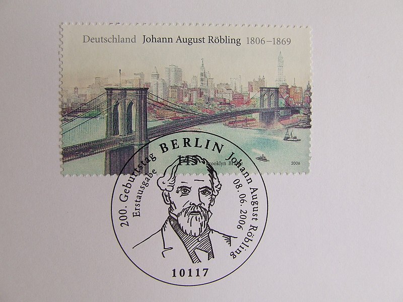
John A. Roebling, a German-born American civil engineer who arrived in America in 1831, was also given the credit for the Brooklyn Bridge.
The Fort Duquesne Bridge in Pittsburgh spans the Allegheny River, from the half-way point between the two stadiums on the north side, and Point State Park where Fort Duquesne and Fort Pitt are both located at the tip of the Golden Triangle, the Central Business District of downtown Pittsburgh, where the fortunes of industrial barons including Andrew Carnegie, Henry Heinz, Andrew Mellon, and George Westinghouse were made.

What else is similar between Pittsburgh and Cincinnati?
There’s the geographic landmark and residential neighborhood of Mt. Adams, a flat-topped-looking earthwork that at one time had an incline Railway.
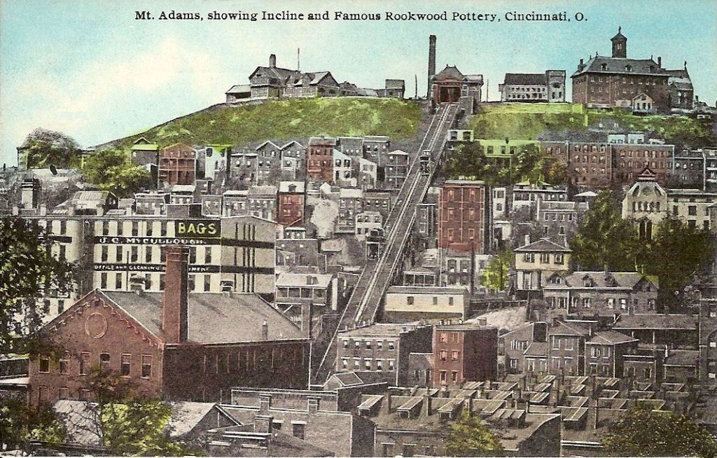
The Mount Adams Incline operated from 1872 until 1948. Long since demolished, it was the longest running incline of Cincinnati’s historic five incline railways.

Mount Adams landmarks include the Cincinnati Art Museum, said to have been built in 1886…

…the Rookwood Pottery Company, which was founded in 1880 and closed in 1967, and the original building was converted into a restaurant, which closed in 2016.

The Rookwood Pottery Company on Mount Adams was said to have been founded in 1880 by Maria Longworth Nichols Storer, a member of Cincinnati’s wealthy Longworth family, after she saw the ceramics at the 1876 Centennial Exhibition in Philadelphia.

The original Rookwood Pottery Company was closed in 1967, and then re-opened in Cincinnati’s Over-the-Rhine neighborhood in 2004.
Other Mt. Adams’ landmarks include:
The Pilgrim Presbyterian Church, said to have been built in 1886…

…near the Ida Street Viaduct, said to have been constructed in 1931 – which would have been during the Great Depression…

…and the Immaculata church and Holy Cross Monastery, said to have been built in 1895 and 1901 respectively…
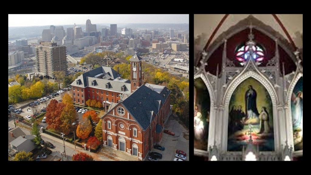
…close to the edge of Mt. Adams overlooking the river, like St. Mary of the Mount back in Pittsburgh…

Another viewer commented: “There were two race tracks near where I live. One in Fenimore NY and another in Glens Falls NY. And there’s still one in operation in Saratoga NY that’s decked out with the usual old world ornamentations. Columns/pillars, brick walls, large iron gates, ornate cement facades. As for the lost two tracks, not much is known other than the one in Glens falls became a neighborhood and the shape of the track is still visible because they just paved over it and incorporated it into the modern road work infrastructure. What were these tracks originally… another mystery!”
Since the Glens Falls and Fenimore tracks are no longer exist, I will focus on the Saratoga Race Course.
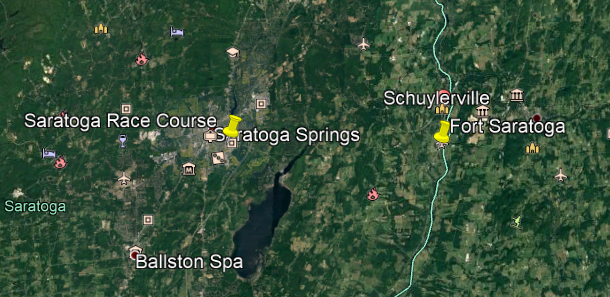
This is a snapshot showing the angular relationships between the Saratoga Race Course, and just a portion of the large number of airparks, airfields, and airstrips in this part of New York State.
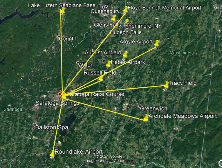
The Saratoga Race Course is a thoroughbred horse racing track in Saratoga Springs, New York. It is one of the oldest sporting venues in the United States, having opened on August 3rd of 1863 (which would have been in the middle of the American Civil War).
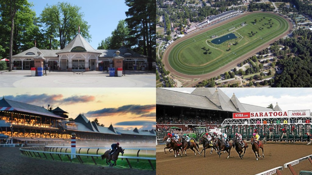
The Saratoga Race Course has been in use pretty much continuously since it first opened.
The name of Saratoga Springs reflects mineral springs that are in the area, making it a popular resort destination for over 200 years.
High Rock Spring in this location is believed to have medicinal properties.

The British were said to have built Fort Saratoga on the west bank of the Hudson River, somewhere south of Schuylerville, in 1691.
Saratoga Springs was established as a settlement in 1819, and as a village in 1826.

What eventually became known as the Adirondack Branch of the Delaware & Hudson Railroad, first arrived here in 1832.
This was the first station used in Saratoga Springs, from 1833 until it burned down in 1870.

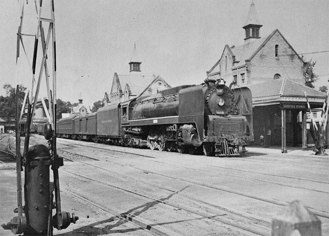
Then, this was the main train station in Saratoga Springs, from 1871, until it burned down in 1899.

This station was said to have been built in 1900, and used until the main-line was re-routed outside of Saratoga Springs in 1959.
And this is the Saratoga Springs Railroad Station today.

And were there trolleys in the history of Saratoga Springs?
You bet there were!
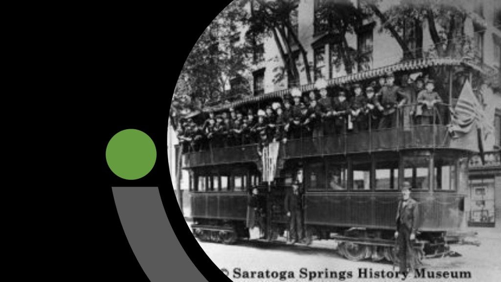
We are told a trolley platform was installed in the area in 1902 with lines to Schenectady and Glens Falls, and the historic trolley station in Saratoga Springs was said to have been designed and built in 1915.
Trolley service ended here in 1938.
Today the building serves as the Saratoga Springs Heritage Area Visitors Center.

And instead of electric trolley cars, there are some trolley buses that still here today.
I am going to take a moment to look at historical star forts on the Hudson River because I believe all of this information to be interconnected.
There may have been more, but these are the ones I can find references too.

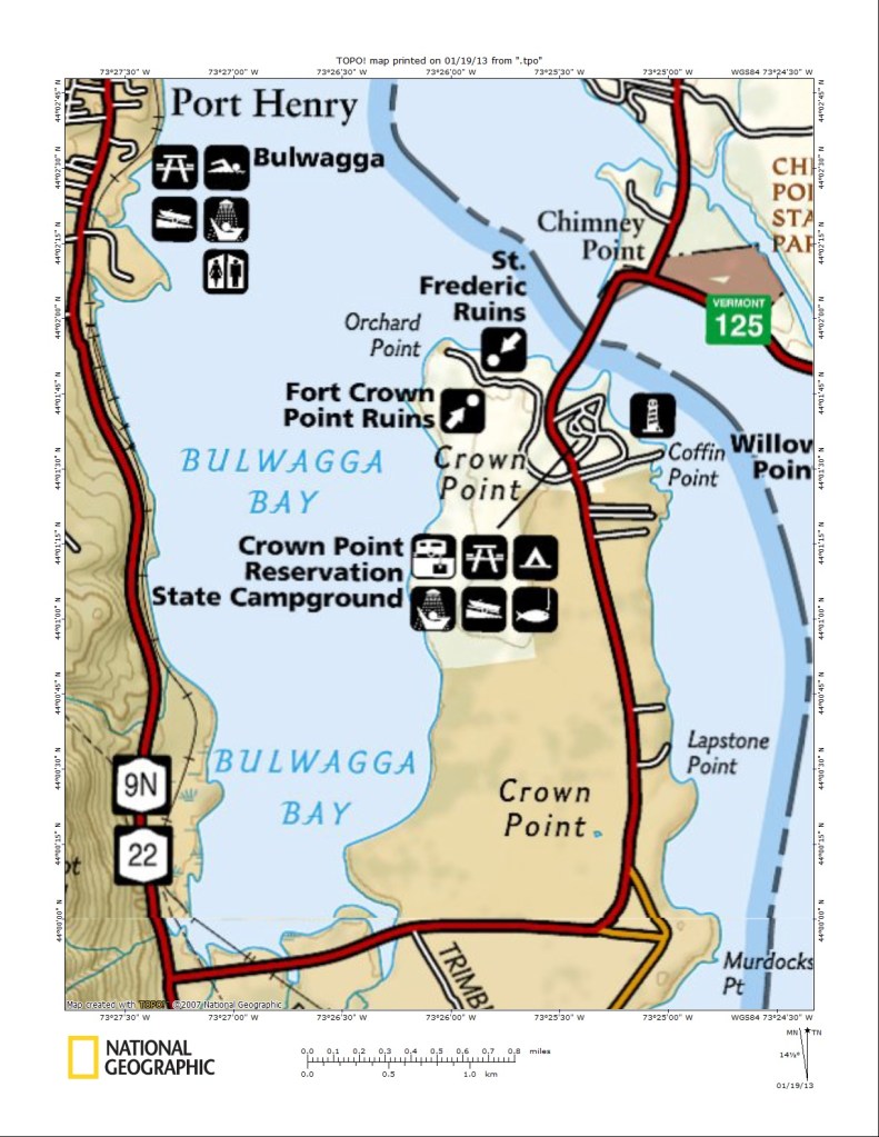
Fort St. Frederic was said to have been constructed by the French starting in 1734 on Lake Champlain at Crown Point, New York, in order to control the lake and to secure the region against British colonization, but that it was already destroyed by 1759 before the advance of a large British Army.
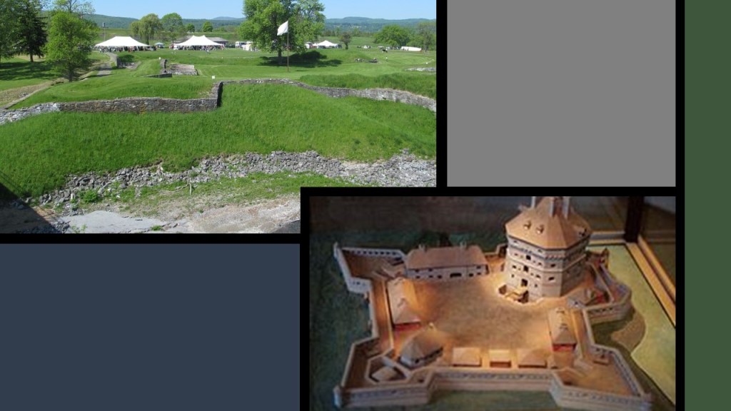
Then, the British were said to have built the much larger Fort Crown Point next to the ruins of Fort St. Frederic in 1759, and this fort fell into ruins after the American Revolutionary War.

The ruins of both of these star forts have been preserved on the grounds of the Crown Point State Historic Site since 1910.
Going down the Hudson River from the north, the next one we come to is Fort Ticonderoga.
Fort Ticonderoga was said to have been built by the French between 1755 and 1757 during the French and Indian War, and was of strategic importance during the 18th-century colonial conflicts between the British and the French, and played an important role during the American Revolutionary War.

It ceased to be of military value after 1781, we are told, and the U. S. Government allowed it to fall into ruin.
It was purchased by a private family in 1820, and it became a tourist stop, and today a foundation operates the fort as a tourist attraction, research center and museum.

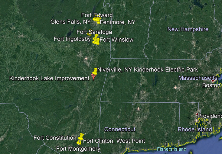
Fort Edward came next, and was located on the Hudson River, just below the town of Fenimore.
There’s not much left of Fort Edward to speak of.
There is a marker at the intersection of Route 97 and Route 4, near the Anvil Restaurant and lounge, thatmarks the site of the northeast bastion of Old Fort Edward, part of the outworks of the fort.

In the middle of what is now a residential neighborhood, there is a marker designating part of what was the old moat of Fort Edward…

…and in a park that overlooks a bend in the Hudson River, there is a big stone with a plaque marking the historic location of Old Fort Edward.

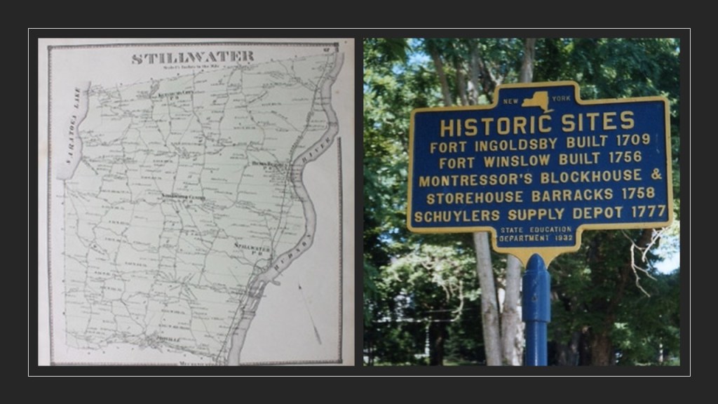
The already-mentioned Fort Saratoga came next, and then a short-distance below Fort Saratoga were Fort Ingoldsby and Fort Winslow, both in Saratoga county in Stillwater, New York.
The next ones I can find references for are a ways on down the Hudson River from here…
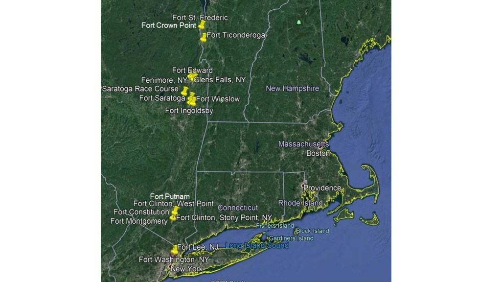
…when we arrive at Fort Clinton and Fort Putnam at West Point.
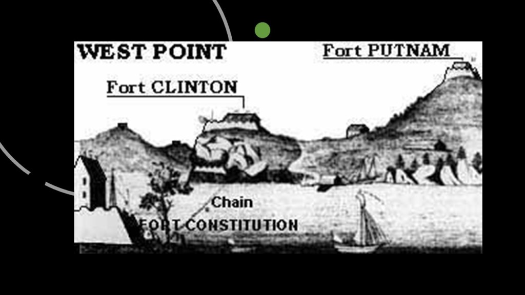
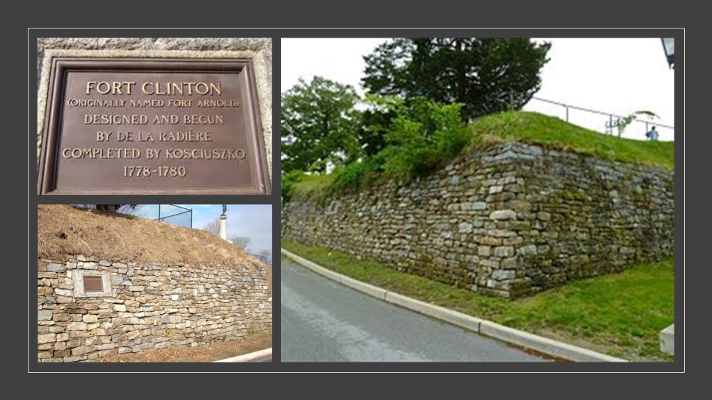
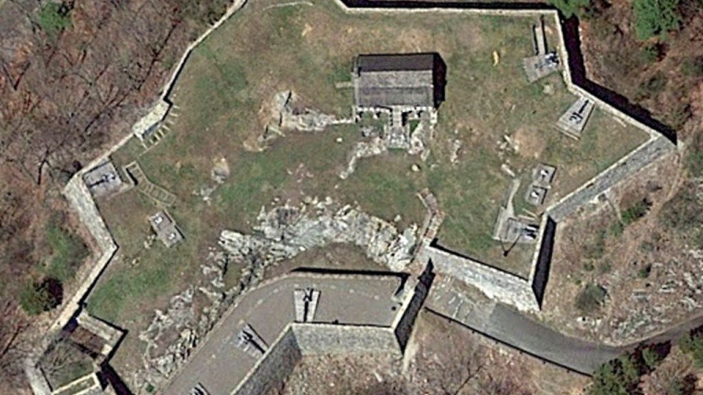
Fort Clinton was said to have been built between 1778 and 1780, and the key defensive fortification overlooking what was called The Turn in the Hudson river, and the Great Chain, two chain booms, literal chains, that were constructed to prevent British naval vessels from sailing upriver.

Originally named Fort Arnold, it was commanded by and named after Benedict Arnold before his betrayal to the United States and defection to the British Army.
The fort was subsequently named after Major General James Clinton.
Fort Putnam was said to have been completed in 1778 with the purpose of supporting Fort Clinton.
Even though it was rebuilt and enlarged in 1794, we are told, it fell into disuse and disrepair as a military garrison, and was obsolete by the mid-19th-century.
Just a short-distance downriver from Forts Clinton and Putnam, we come to Fort Constitution.
Captured and destroyed by the British in October of 1777, the fort was said to have been partially reconstructed by the American forces after it was abandoned by the British, and it became one of the anchor points for the Great Chain across from West Point.
It was completely abandoned after the revolutionary War.

Also destroyed by the British in 1777, were the nearby Forts of Montgomery…

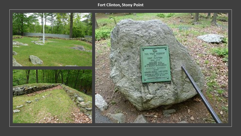
…and Fort Clinton at Stony Point, named after Brigadier General George Clinton of the New York Militia, and commander of the fort before it was captured by the British and destroyed.
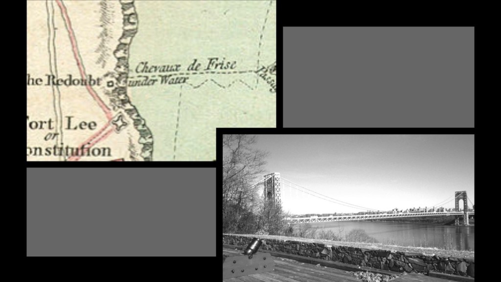
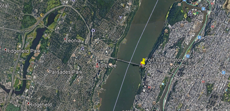
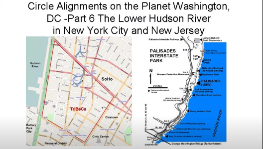
The last two forts I want to look at on the Hudson River are Fort Washington in Manhattan, and Fort Lee in New Jersey.
Fort Washington was a fortified position at the island’s highest point near the north-end of Manhattan, said to have been constructed to prevent the British from going upriver starting in June of 1776 by Pennsylvania battalions of the Continental Army for General George Washington.

Fort Lee, also known as Fort Constitution, was said to have been constructed starting in July of 1776 on top of a bluff on the Hudson Palisades directly across the river from where Fort Washington was concurrently being built on the other side.
Alas, all of the hard work needed to build these fortifications came to nothing, since we are told that in November of 1776, in the Battle of Fort Washington, troops under the command of British General William Howe and Hessian General Wilhelm von Knyphausen made short work of the American forces stationed there, capturing both the forts, and taking a little over 2,800 American prisoners, of which only around 800 were said to have survived after being being kept in substandard conditions on-board British ships in New York Harbor.

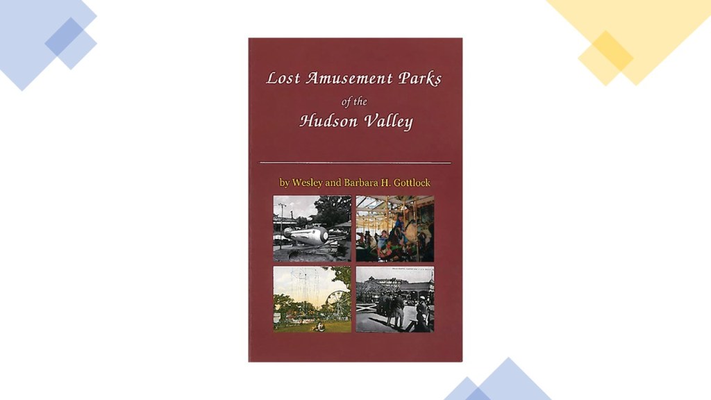
Now after looking at historical star forts of the Hudson Valley, I want to look next into the lost amusement parks of the Hudson River, including but not limited to…
…Palisades Amusement Park, in Cliffside, New Jersey, which was located next to Fort Lee.
The trolley park was in operation from 1898 until its closure in 1971.
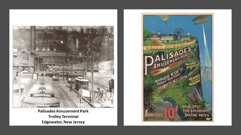
Palisades Park was the first trolley park I ever stumbled across when I was doing research here in May of 2019 following cities and places in a circular alignment from Washington, DC…
…and where I first learned that trolley parks were said to have started out in the United States in the 19th-century as picnic and recreation areas at the ends, of street-car lines, and that by the 1920s, these trolley/amusement parks started to suffer a steep decline for a variety of reasons
For example, at one time, there was a trolley park called Electric Park in the Hudson River Valley on Kinderhook Lake at the town of Niverville, New York.
It was described by some as the largest amusement park on the east coast between Manhattan and Montreal during its run from 1901 to 1917.
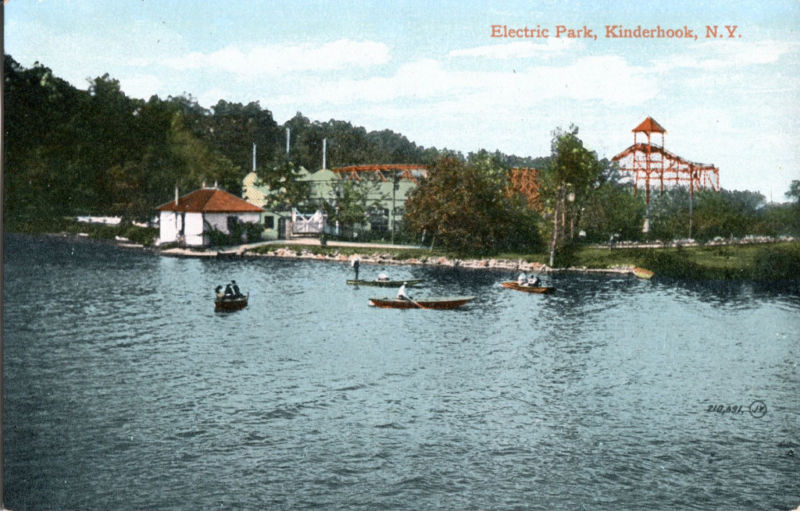
We are told this Electric Park was created by the Albany & Hudson Railroad Company in order to increase ridership on weekends.
The reasons given for the closing of the Electric Park of Niverville in 1917 was that the popularity of automobiles no longer restricted people to rails and river steamer transportation; World War I; and high insurance premiums due to the number of trolley parks that had burned down.
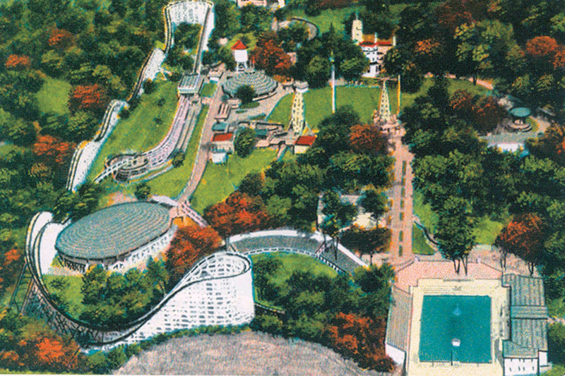
The Woodcliff Pleasure Park in Poughkeepsie, New York operated from 1927 to 1941.
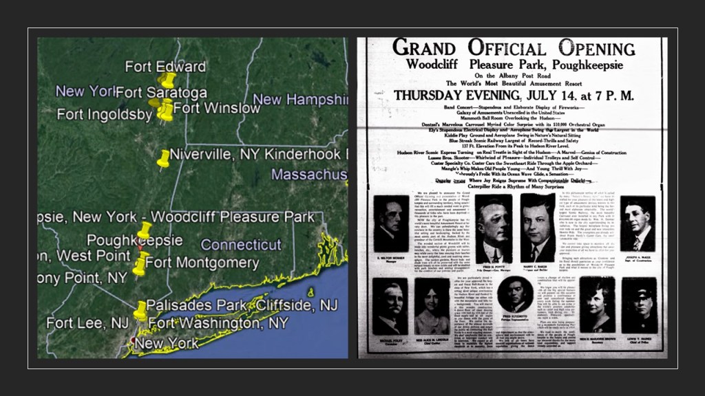
It was the home of the Blue Streak roller coaster, the highest and fastest roller coaster anywhere during its time, and one of the largest swimming pools in the country.
The Woodcliff Pleasure Park was said to fall on difficult times, and was permanently closed in 1941.
Leaving New York State, I am heading to New Orleans, Louisiana because a viewer suggested that I look at the racetracks in relationship to the New Orleans International Airport in Kenner, Louisiana, as well as Fort Jackson further down the Mississippi River from New Orleans.
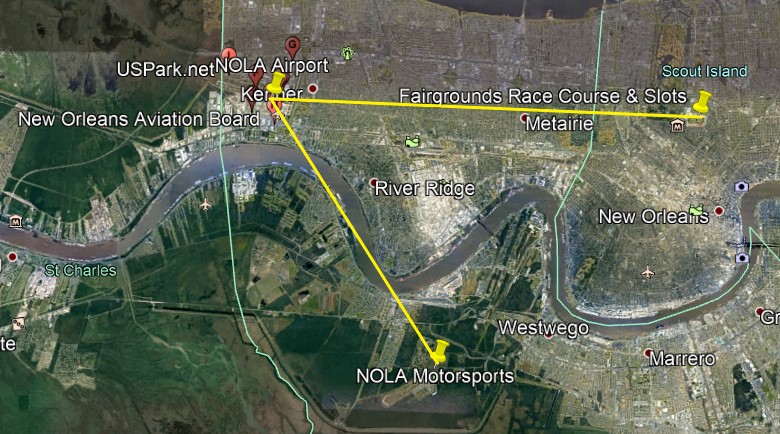
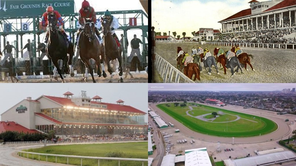
The Fair Grounds Race Course is a Thoroughbred racetrack and racino, combined racing and casino, venue said to have originated in 1838 when some horse races were organized at the “Louisiana Race Course,” which was renamed the Union Race Course in 1852.
In 2009, the Fair Grounds Race Course was ranked #12 in a rating system for 65 Thoroughbred racetracks in North America, and is the home of the Louisiana Derby, which was established in 1894.
It is run in late March with a purse of $1,000,000, and is a major prep race for the Kentucky Derby.
The NOLA Motorsports Park opened in 2011, and is considered the Gulf South’s premier motorsports complex.
It has electronic systems, including over 100-miles, or 161-kilometers, of fiber optics, as well as state-of-the-art timing and scoring equipment.

It offers supercar racing for those seeking the experience.

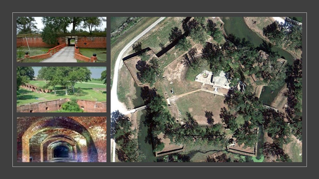
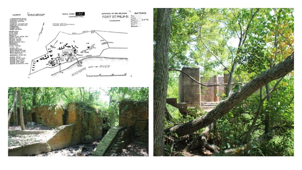
Now time to take a look at southern Louisiana’s Fort Jackson, and Fort St. Philip, both located 40-miles, or 64-kilometers, upriver from the mouth of the Mississippi River.
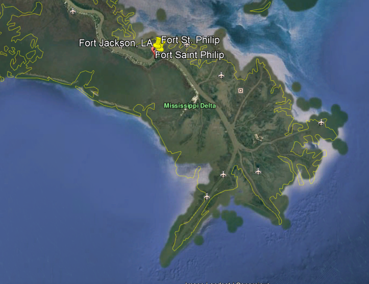
Fort Jackson was an historic masonry fort said to have been constructed as a coastal defense of New Orleans between 1822 and 1832.
It is marked “Battery Millar” on some maps.
Fort Jackson was attacked and damaged by Union mortar and gunboats during the American Civil War from April 18th to April 24th of 1862.
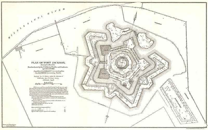
Today, Fort Jackson is a National Historic Landmark and museum.
Fort St. Philip is located across the Mississippi River from Fort Jackson, and was said to have been constructed in the 18th-century when the Spanish governed Louisiana, and is a privately-owned National Historic Landmark in a bad state of deterioration.
It was also said to have been attacked by Union forces at the same time as Fort Jackson, in April of 1862, during the Civil War.
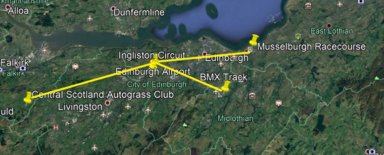
Another commenter drew my attention to Edinburgh, the capital of Scotland and its seat of government.
Here we find the Ingliston Circuit a short-distance to the southwest of the Edinburgh Airport.
It was a motor-racing circuit that was first in use between April of 1965 and September of 1994.
It has tight corners, and numerous obstacles such as trees and buildings close to the track.
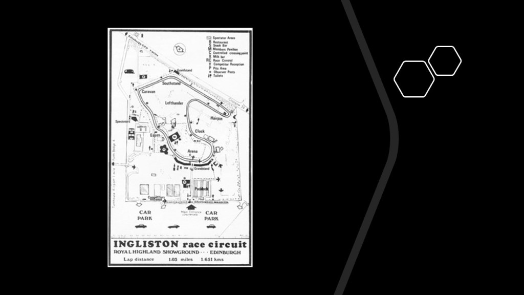
Use of the racing track was revived around 2015 to provide a supercar driving experience, like the NOLA Motorsports Park.

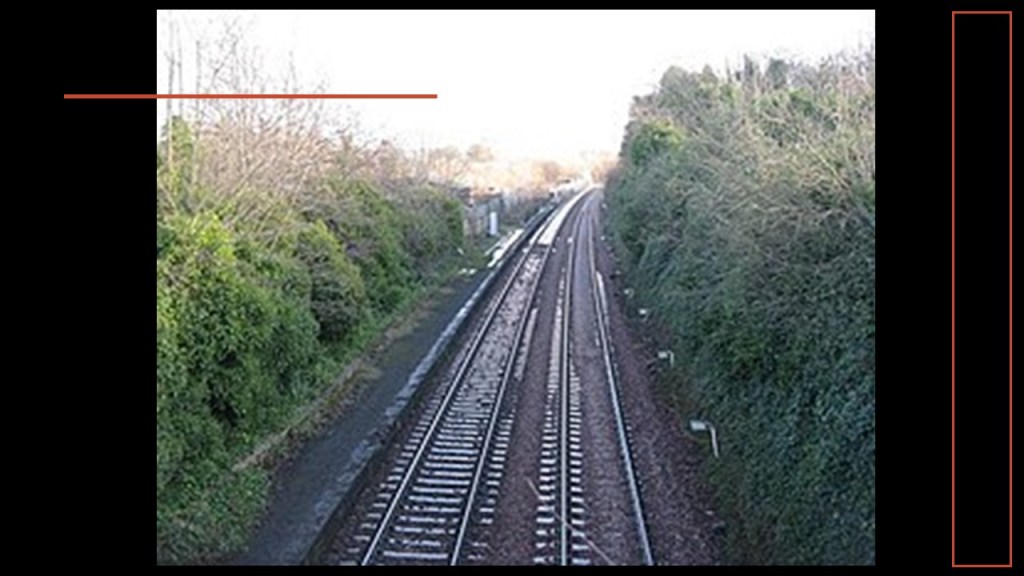
It is interesting to note Ratho Station and the presence of train tracks in the vicinity of the airport and racing circuit.

Ratho Railway Station served the village of Ratho on the Edinburgh and Glasgow Railway between 1842 and 1951, at which time it was closed.
But there are more racetracks to find in Edinburgh in the vicinity of the airport.
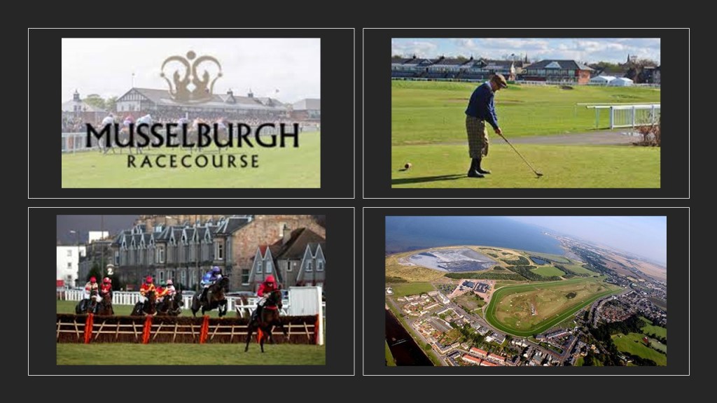
To the east of Edinburgh Airport is the Musselburgh Racecourse.
Since 1816, the Musselburgh Racecourse has been a horse-racing venue for both flat races and National Hunt meetings, where horses jump fences and ditches.
The second-largest racecourse in Scotland, it also has a 9-hole golf course in the middle, said to date from around 1672.
The off-road BMX Track in Loanhead, located to the southeast of the Edinburgh Airport, is in the vicinity of Rosslyn Chapel.

Rosslyn Chapel was featured in Dan Brown’s 2003 novel “The Da Vinci Code.”
It is frequently the subject of speculative theories about the Knights Templar and the Holy Grail.

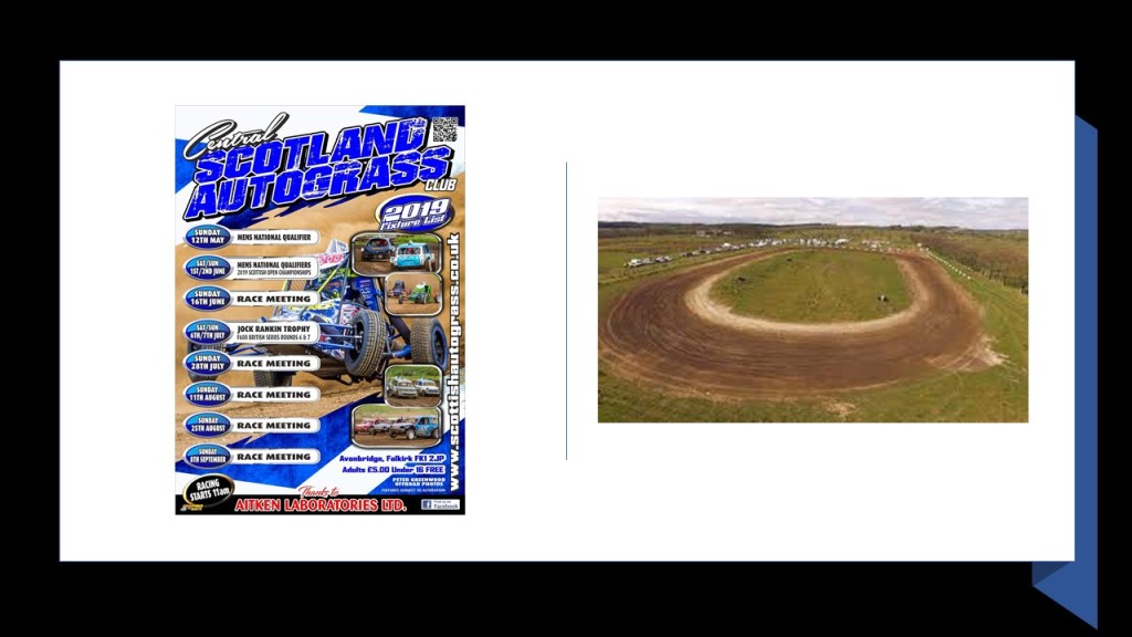
One last race track that popped up is the Central Scotland Autograss Club, slightly southwest of the Edinburgh Airport.
The Central Scotland Autograss Club holds non-contact car races, usually between March and November every year, on a natural-surface track.
Another commenter suggested that I look into the Santa Cruz Beach Boardwalk, on the ocean with closed down railroad tracks beside it.
The Santa Cruz Beach Boardwalk is an operating amusement park in Santa Cruz, California.
It opened in 1907, and is California’s oldest-surviving amusement park.

The eastern end of the boardwalk is dominated by the Giant Dipper, a wooden rollercoaster said to have been built in 1924.
This wooden roller coaster, and the Looff Carousel, hand-carved by Danish woodcarver Charles Looff, and delivered to the Boardwalk in 1911, are both on the National Register of Historic Places.
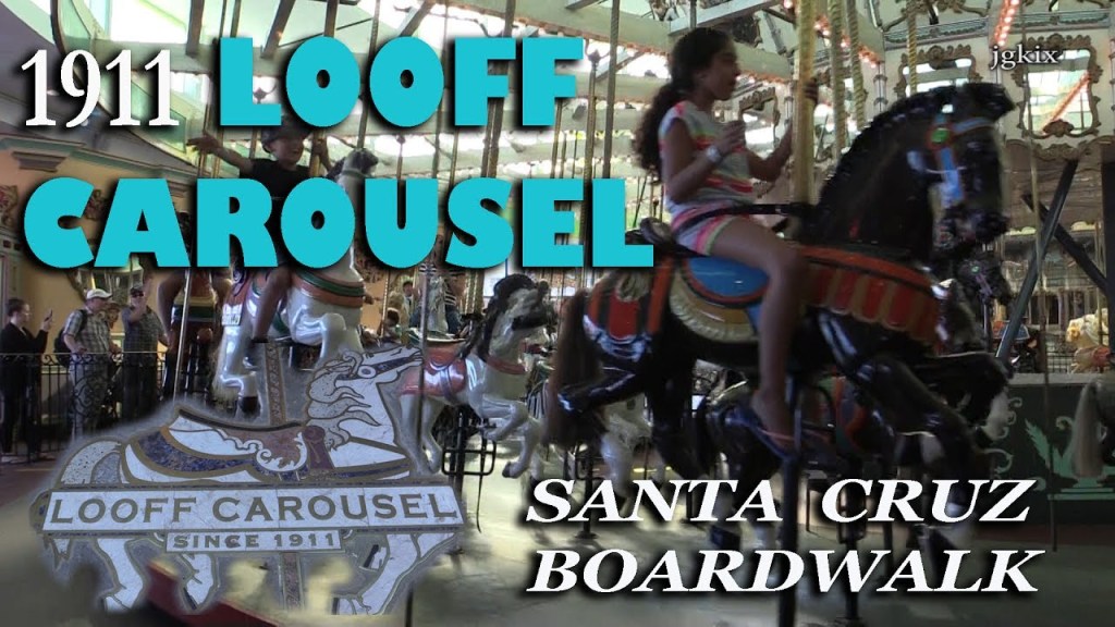
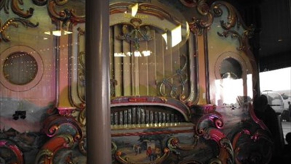
The music for the carousel is provided by a 342-pipe Ruth und Sohn band organ said to have been built in 1894 and imported from Germany.
It has an operating mechanism similar to player pianos.
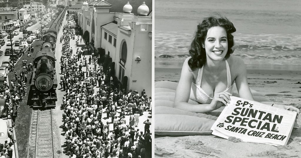
The Santa Cruz Beach Boardwalk was a destination for railroads and trolleys starting in 1875.
By 1926, all of the streetcars of Santa Cruz had been replaced by buses.

Like Saratoga Springs, the only trolleys in Santa Cruz these days are buses!

In the early 1900s, Santa Cruz was connected to the “Suntan Special,” a system of excursion trains run by the Southern Pacific Railroad that went from Bay Area destinations to the coast. The last “Suntan Special” train ran in September of 1959.
The next place I am going to look at is West Baden Springs in French Lick, Indiana.
AW emailed me photos of West Baden Springs in French Lick, Indiana, with these comments:
“Built in 1901 with Moorish architecture, it had the Largest Dome in the World.”

“It had several mineral springs named after Greek and Roman Gods…”
“…a trolley system…”
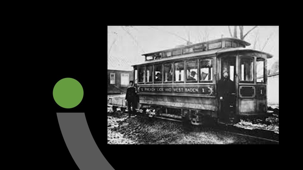
“…the largest bicycle track in the country and its a covered double decker…”

“…a natatorium, another name for an indoor swimming pool…”

” …and even a cathedral.”

He also said that for a while after 1934 the West Baden Hotel was a Jesuit Seminary…
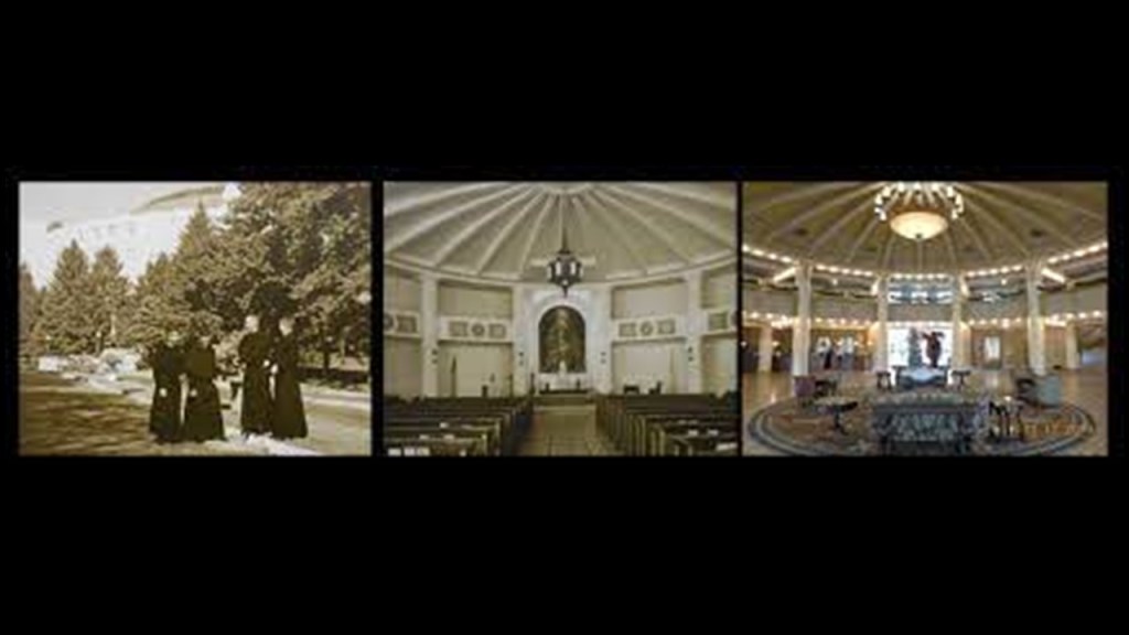
…and the Jesuits had an astronomical observatory on the West Baden Hotel grounds.

Today, the West Baden Hotel is a popular tourist destination…

…with a modern natatorium…

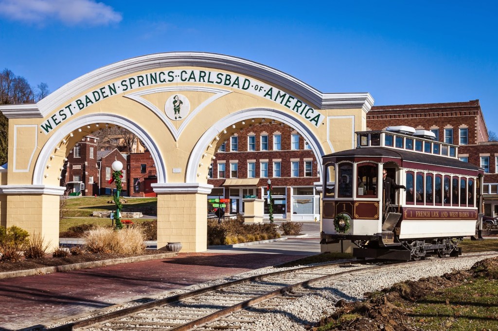
…and a restored trolley car line between West Baden Resort and French Lick Resort in Indiana’s “Springs Valley.”
The double-decker bicycle track, however, was said to have been nearly demolished by a windstorm that blew through the area on July 25th of 1925…

…and when the owner received an insurance check for $100,000, he tore the rest of the structure down, and it was gone by the fall of 1925…

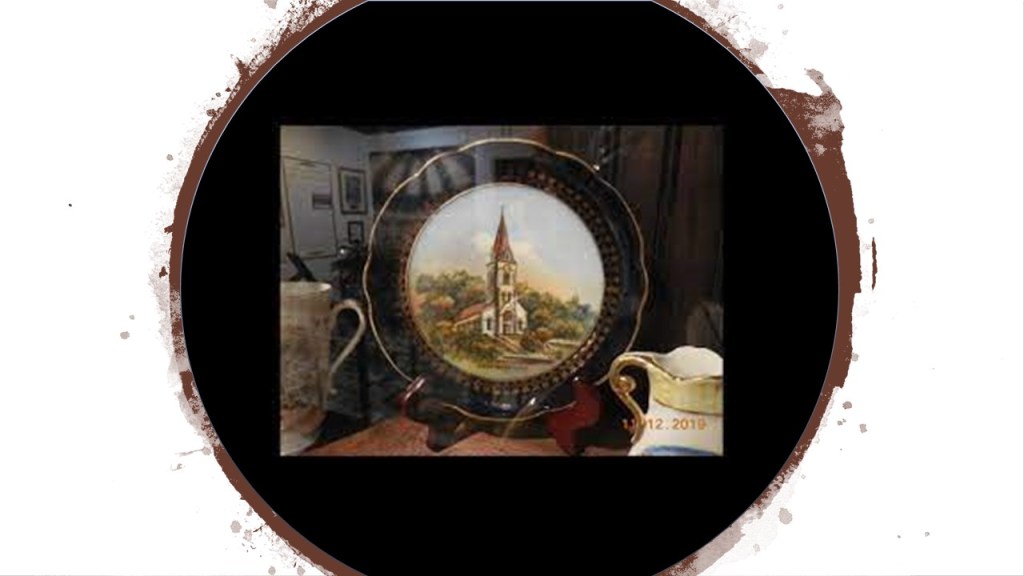
…and the Our Lady of Lourdes Catholic Church was pulled down in 1934 when it was deemed structurally unsound by someone, and only remembered on post cards and souvenirs.
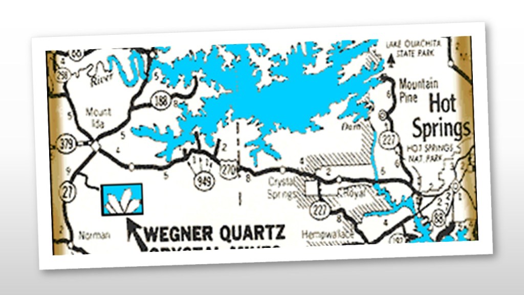
The last place I am going to look into in this post is Hot Springs in Arkansas.
I had several comments from two viewers to research.
First, CC mentioned the following about Hot Springs.
“The resetters burned the city in the early 1900s.”
So I looked, and found out that a fire started on Church Street in Hot Springs on September 5th of 1913 near the Army and Navy Hospital and Bathhouse Row.
An estimated $10 million in damages from the fire occurred across 60 blocks…

…destroying much of the southern part of the city.

CC also said that Hot Springs has a horse racing track, and a casino, which is located near the Memorial Field Airport.

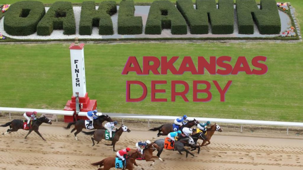
The Oaklawn Racing Casino Resort is a thoroughbred horse-racing track that first opened in February of 1905.
It was ranked 5th in 2017 by the Horseplayers Association of North America.
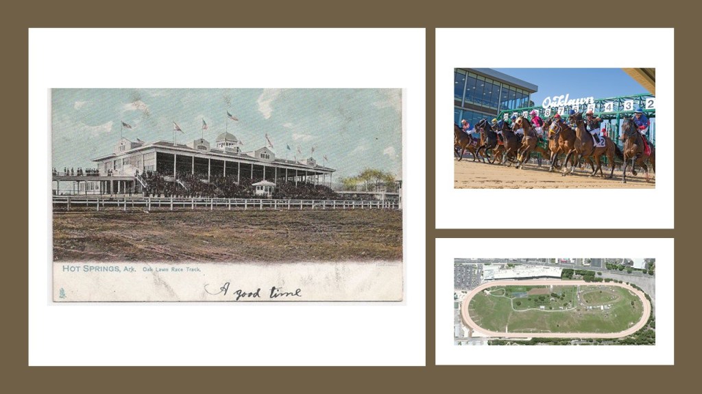
It is home to a number of races, like the “The Racing Festival of the South,” which is held in April every year…

…and includes the running of the Arkansas Derby, which has a $1 million purse.
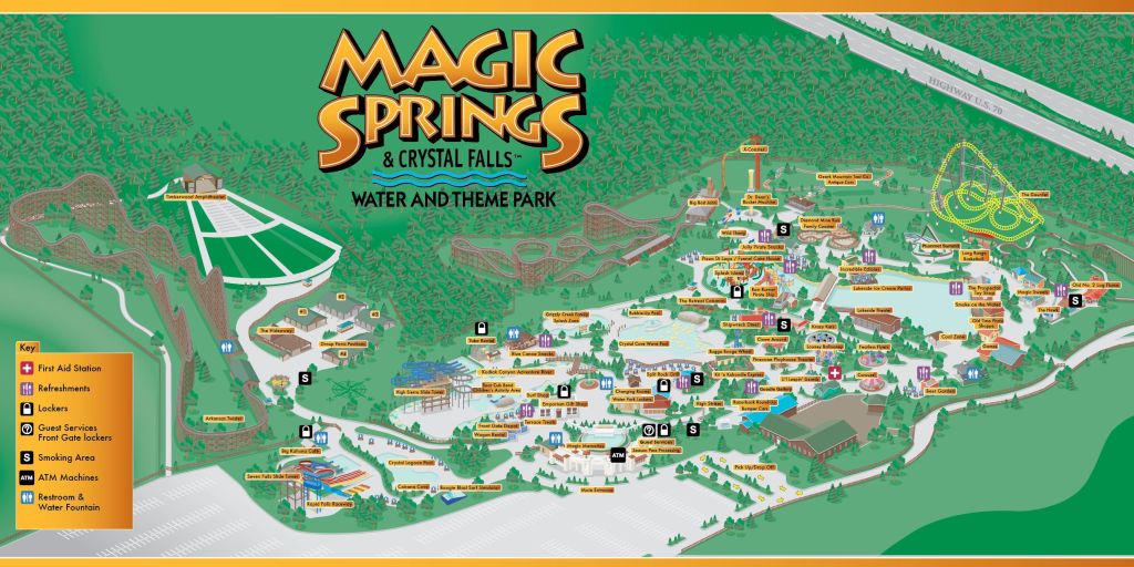
CC indicated there is an amusement park in Hot Springs called Magic Springs, which first opened in 1978, closed due to financial problems in 1995, and re-opened in 2007 as Magic Springs and Crystal Falls Water and Theme Park.
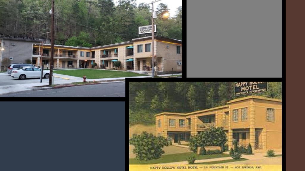
The only reference to an historical amusement park in Hot Springs that I could find was McLeod’s Amusement Park, more commonly known as Happy Hollow, one of Hot Springs most popular tourist attractions from the late 1800s to the 1940s.
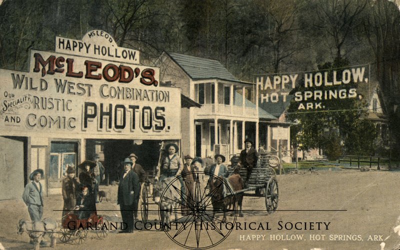
It was located north of Hot Springs Mountain at the head of Fountain Street, just off Central Avenue…
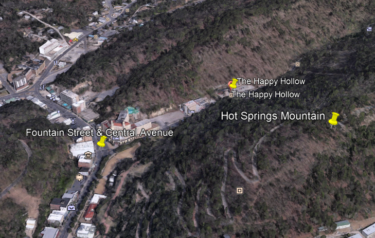
…and all that remains of it are the Happy Hollow Hotel…
…and the Happy Hollow Jug Fountain from a spring that supplies cold mineral water.

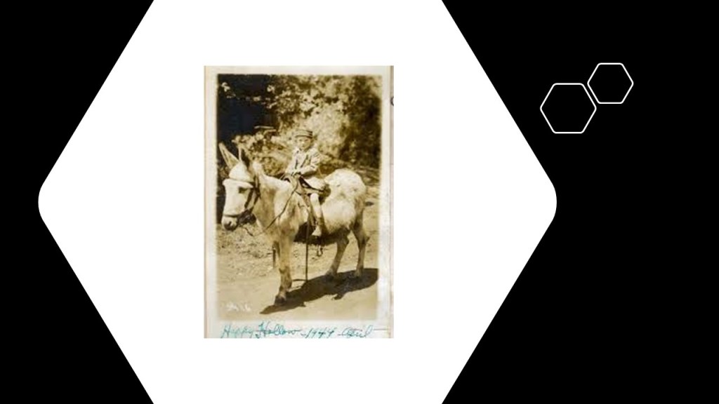
Happy Hollow was established by photographer Norman McLeod as a picture studio in 1888…
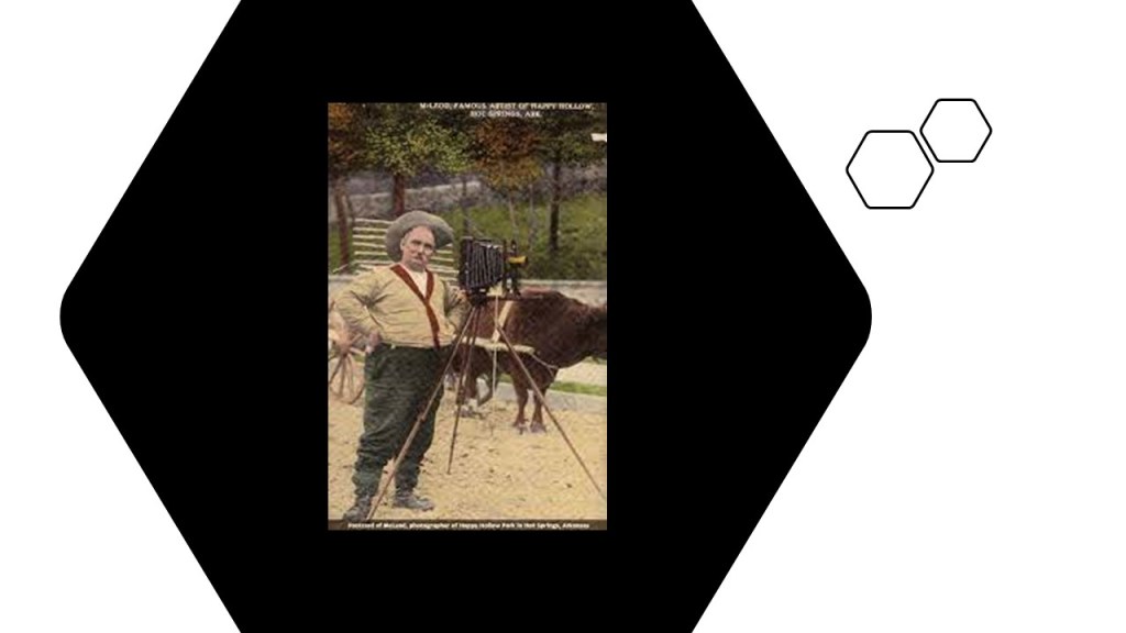
…and it grew into an amusement park that contained a shooting gallery, zoo and souvenir shop, as well as an assortment of burros, ponies, and horses for visitors of all ages to ride.
The park was best known, however, for its humorous photographs.

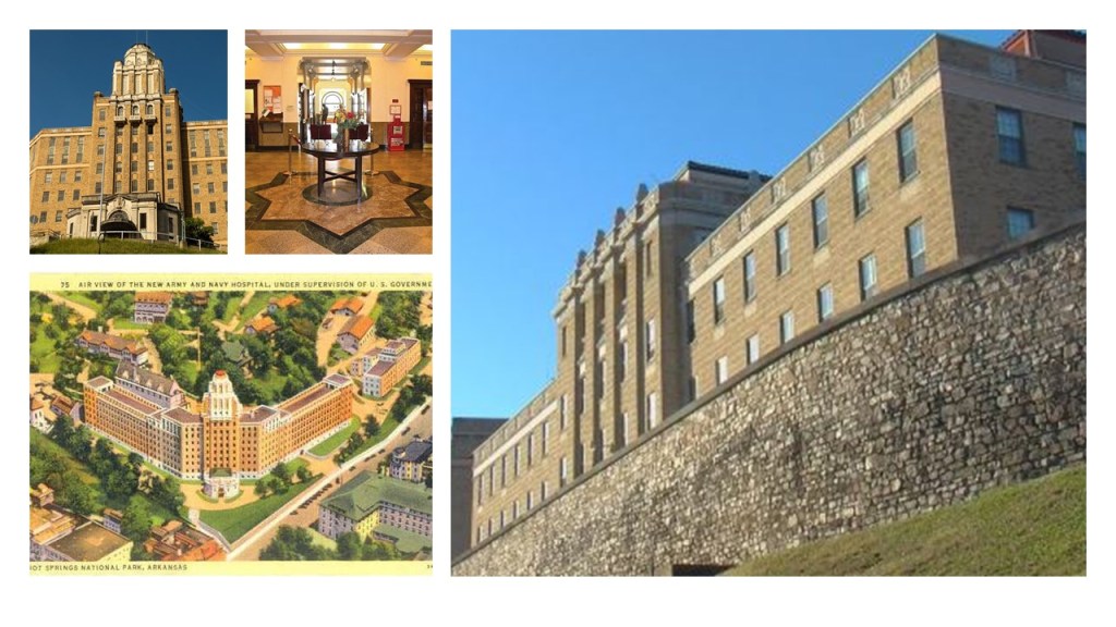
CC said there was a huge armory hospital in Hot Springs that was a massive star fort!
He was referring to what used to be the Army and Navy Hospital, which is now a state-run rehabilitation center.

The former Army and Navy Hospital, the first general hospital in the country that treated both Army and Navy patients starting in January of 1887, appears to be situated at the bottom of Hot Springs Mountain, just around the corner from Happy Hollow on the north-side of Hot Springs Mountain.

What we are told is that in the early 1930s (which would have been during the Great Depression), the original building was replaced with a brick-mortar and steel facility with 412-beds.
SD, who also lives in Hot Springs, commented about the old Army and Navy Hospital, and about Hot Springs Mountain as well, as, among other things, she said that it was the first federally-protected land in the United States.
Hot Springs Mountain was turned into a reservation by an Act of Congress on April 20th of 1832, and was the first time that land had been set aside by the federal government to preserve its use as an area for recreation, and the city of Hot Springs was incorporated on January 10th of 1851, and Hot Springs Mountain became a National Park in 1921.

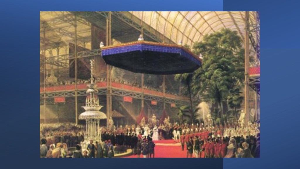
I believe the Crystal Palace Exhibition in London, which ran from May to October of 1851, the year Hot Springs was incorporated, was the official kick-off event for the New reset timeline, which was hijacked from the original positive ancient, advanced Moorish civilization.
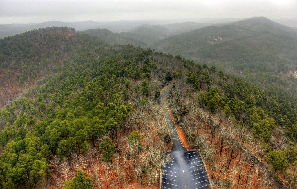
The hot springs flow from the western slope of Hot Springs Mountain, which is part of the Ouachita Mountain range of Arkansas.
The Washitaw Mu’urs go back in history to Mu or Lemuria, and are also known as the Ancient Ones.
They were recognized by the United Nations as the oldest indigenous civilization on Earth in 1993.

Ancient does not refer to the distant past – it refers to an ancient people living in the present-day.
How come we’ve never heard anything about them?
Quite simply, the Controllers don’t want us to know.
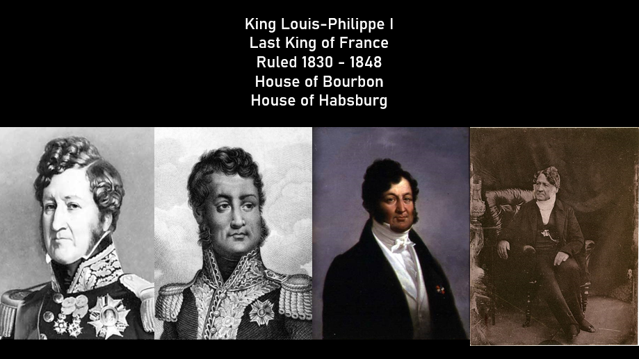
Their Ancient Imperial Seat of Government is in Washitaw Proper, in the area of Monroe in Northern Louisiana, and it is a matriarchal civilization and culture ruled by an Empress of ancient bloodlines that were shared by the Bourbon Habsburg Empire of Western Europe.
These are several depictions showing different skins colorsof Louis-Philippe I, the last King of France of the House of Bourbon, a branch of the House of Habsburg, who was forced to abdicate after the outbreak of the French Revolution of 1848.
Back to Hot Springs.
SD said Hot Springs was also called Valley of the Vapors because when the hot water steam arose there were rainbows that were seen…
…and Hot Springs Mountain has 47 natural springs that have been capped off and piped into bathhouses, and that the bathhouses that still stand, specifically the Fordyce Bathhouse with a museum is fascinating…

…but all of them are beautiful.
Bathhouse Row is maintained by the National Park Service, eight historic bathhouse buildings and gardens along Central Avenue.

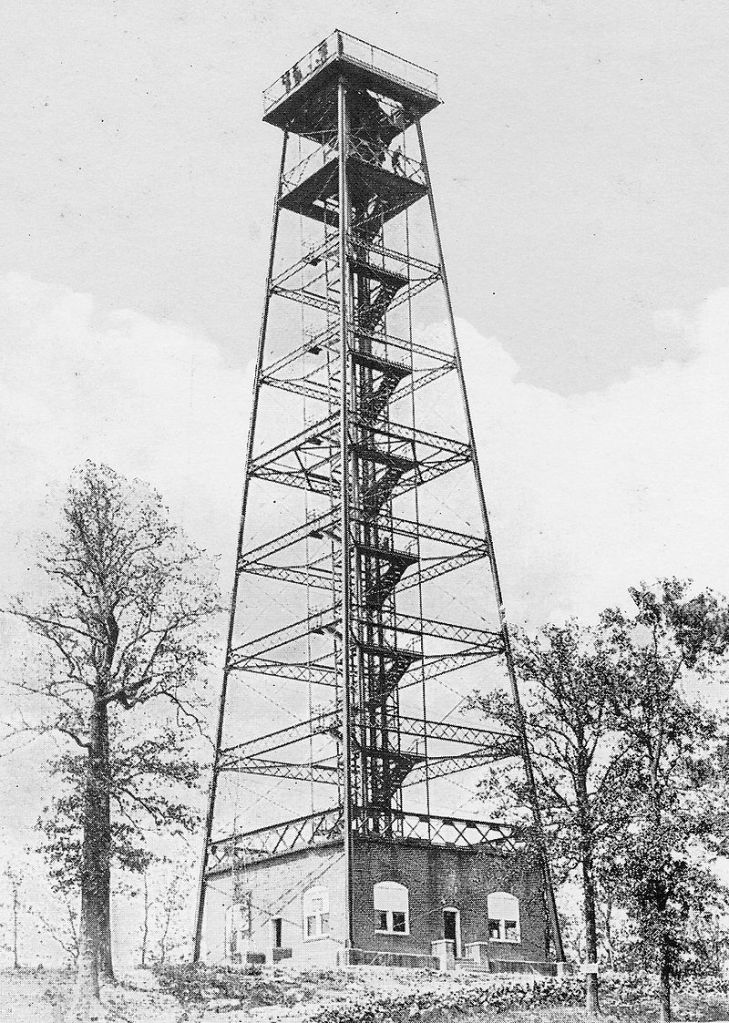
There is an observation tower on top of Hot Springs Mountain.
Construction of this one was said to have started in 1982, and opened to the public in 1983…
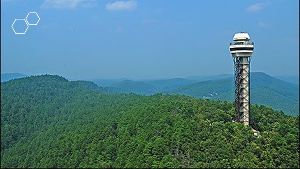
…but that there were two towers here previously.
The first was said to be a a 75-foot, or 23-meter, -high wooden observatory constructed on the site in the 19th-century that was struck by lightning and burned to a ground, and then in 1906, the 165-foot, or 50-meter, -high wireless telegraph tower from the 1904 Louisiana Purchase Exposition in St. Louis, Missouri, was relocated to Hot Springs Mountain until it was torn down in 1975, with the given reason due to its instability.
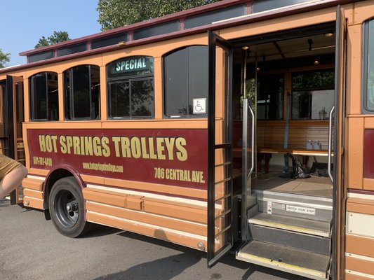
SD mentioned that Hot Springs also had electric rail cars at some point in time.

I found out that the Hot Springs Street Railroad ran around Hot Springs to and from the Oaklawn Race Track.

…and yes, there are trolley buses here today too.
SD also said there was a large solid and pure quartz crystal vein, that Hot Springs sits within or just outside of, that runs approximately 200-miles, or 322-kilometers, that starts in Oklahoma, runs through the Ouachita Mountains, and ends close to the state capital of Little Rock.
There is more I can delve into in Hot Springs, but I am going to stop right here.
So, what are the odds of all of these similar relationships and connections happening randomly in diverse places across the world over long periods of time?
I think the truth of what we are actually seeing, the components of a very precise and integrated, world-wide, electromagnetic free-energy-generating-and-receiving geometric grid system, is actually hidden within our every day language – in circuits (race tracks), batteries (star forts), terminals and engines (all rail-lines) and the definition of spring.
The sport of racing uses the word “circuit” in the following ways:
- The course over which races are won.
- The number of times the racers go around the track.
- An established itinerary of racing events involving public performance.
- Circuit race – a mass-start road-cycle race that consists of several laps of a closed-circuit, where the length of the lap is slightly longer each time.
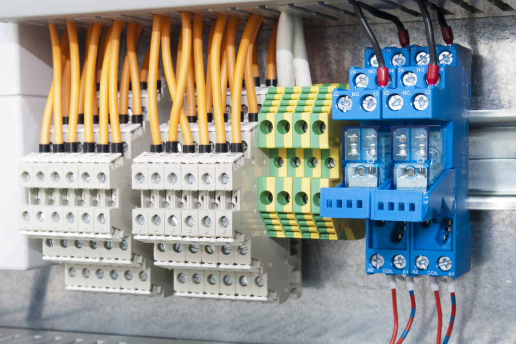
Electrical Circuit definitions Include:
- A closed path in which electrons from a voltage or current source flow.
- An electric circuit includes: devices that give energy to the charged particles the current is comprised of, such as batteries and generators; devices that use current, like lamps, electric motors, and computers; and the connecting wires or transmission lines.
- An electronic circuit is a complete course of conductors through which current can travel. Circuits provide a path for current to flow.
Wouldn’t it stand to reason that those behind the reset when setting up the New World would take advantage of the super science of the different types of circuits in the Earth’s grid system in order to harness their inherent power to enhance performance at sporting events, to make lots of money at highly-charged, prestigious gaming and betting venues, with the added excitement of large crowds spending large amounts of money on the factor of chance?

As we have seen in examples given here, the word “battery” is typically associated with star forts, and I think that is telling us what their true function was.
And so many more star forts have been destroyed than are still intact.
A battery is a device that produces electricity that may have several primary or secondary cells arranged in parallel or series, as well as a battery source of energy which provides a push, or a voltage, of energy to get the current flowing in a circuit, which aligns with the examples of star forts occurring in pairs or clusters of three or more.

And the word terminal is associated with rail-lines, as in the example given back with the electric streetcar line that ended in Toledo Beach, defined as “The end of a railroad or other transport route, or a station at such a point” and “A point of connection for closing an electric circuit.”
Trolley amusement parks were typically located at the end of streetcar lines.
Was there some kind of enhanced energy-generation going on with trolleys and amusement parks on the earth’s free-energy-generating system?
The other definition of a terminal is: “A point of connection for closing an electric circuit.”
While Engines are also strongly associated with train locomotives, as seen in the second definition of engine.
The first definition show here is “a machine with moving parts that converts power into motion.”
Is that actually telling us the function locomotives performed on the Earth’s free-energy-generating grid system?

As seen in this post, there is also some kind of connection to different kinds of mineral springs with regards to all of this infrastructure.
Definitions of the word spring include:
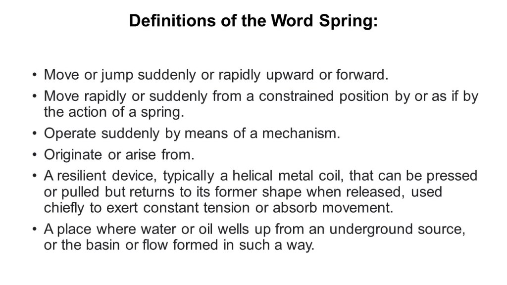
I don’t know exactly what the function of mineral springs would be on this free-energy-generating system, but it could very well be contained within one or all of the non-water definitions.
And what is the function of quartz crystals in electronics?
Though quartz crystals have several applications in the electronics industry, they are mostly used as resonators in electronic circuits.

If you apply an alternating voltage to a quartz crystal, it causes mechanical vibrations. The cut and the size of the crystal determine the resonant frequency of these vibrations or oscillations, and it generates a constant signal.
A Big Thank You to everyone who has taken the time to make suggestions of places to research – your input has helped me enormously in this process, and you have me looking at places that I would not otherwise think to look in making these connections to the bigger picture.

I will return to my viewer comment list, on which I still have lot of comments, but I am going to switch gears and do more in-depth research on the Ernestine House of Wettin from Germany, which produced the House of Saxe-Coburg and Gotha, of which both Queen Victoria and Prince Albert were a part, and through them, seeded the new Royal Houses of Europe, after the original Royal Houses of the Ancient Regime were dismantled.


Portland Oregon has the Portland International Airport, the Portland Meadows Racetrack, both currently in use, and the Jantzen Beach Amusement Park of 123 acres, the “Coney Island of the West,” which was open from 1928-1970, all in the same vicinity on the Columbia River. This configuration fits quite exactly within your current research.
https://en.wikipedia.org/wiki/Jantzen_Beach_Amusement_Park
https://duckduckgo.com/?q=portland+meadows+race+track+portland+or&atb=v161-1&ia=web&iaxm=about
https://duckduckgo.com/?q=portland+international+airport&atb=v161-1&ia=web
LikeLike