An Analysis of Archeoastronomy and Observatories Throughout Time

We are taught that humans went from being hunter-gatherers, and “peopling the earth,” prior to 8,000 BC, to developing settled agriculture and raising livestock during neolithic times, the period of Earth’s history beginning around 8,000 BC and lasting until around 600 BC. This in turn, we are told, led to permanent settlements and the rise of civilizations.

The problem with this description of human evolution is what our Ancestors were actually accomplishing during early neolithic times, and it went far, far beyond what we are told Humanity was capable of. It has to do with the consummate aligning of Heaven and Earth worldwide, with the perfect implementation of sacred geometry and astronomical alignments in the landscape, as well as with the measurement of astronomical and cyclical time through careful observations of the heavens over a very long period of time.

We are explicitly taught that indians wearing loincloths were responsible for building the perfectly geometrically- and astronomically-aligned mounds and earthworks, one basketful of dirt at a time, especially where mounds in North America are concerned.

I will show you exactly why this assertion does not hold up under scrutiny in this post.

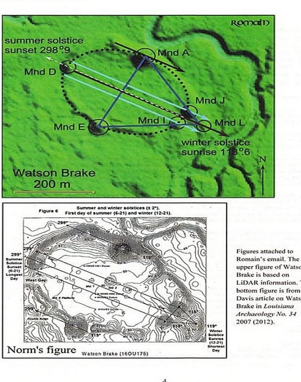
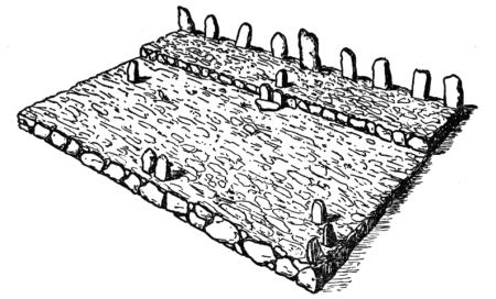
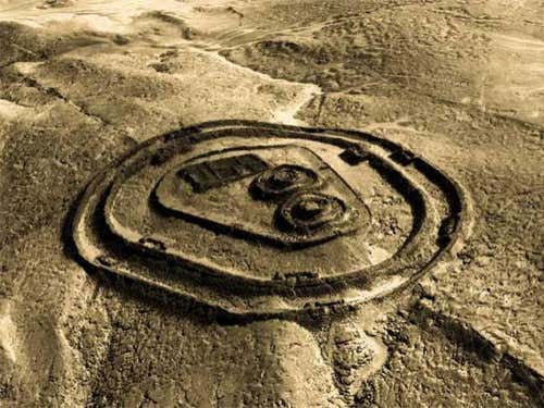
Watson Brake in Richwood, Louisiana, near Monroe, is dated to 5,400 years ago, and is considered is the oldest earthwork mound complex in North America.

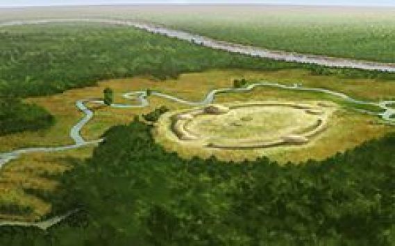
It is located on private property, and is not open for public viewing.

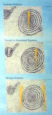
Note the summer and winter solstice alignments depicted here in this diagram of Watson Brake.

This is the famous Stonehenge in Southern England, believed to date to about 5,100 years ago, and has a similar earthwork to what is seen at Watson Brake in Louisiana encircling the big stones.

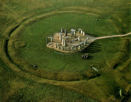
…which is well-known for its solstice alignments.

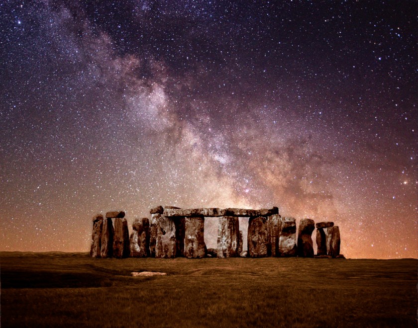
Stonehenge has a really nice alignment with the Milky Way as well.

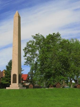
For those of you who may not be aware of it, there is a so-called modern replica of Stonehenge in Maryhill, Washington, said to have been commissioned in the early 20th-century by the wealthy entrepreneur Sam Hall, and dedicated on July 4th, 1918, as a memorial to the people who died in World War I.

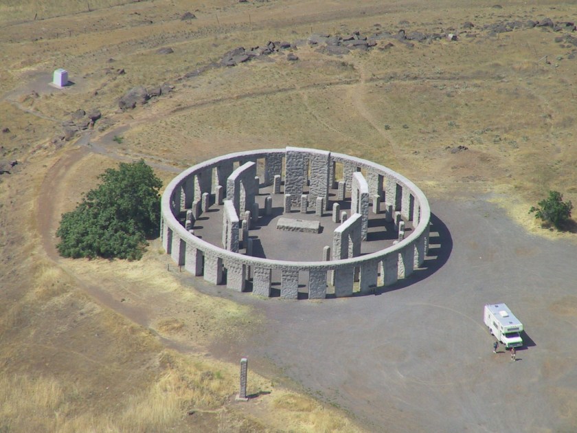
In addition to having a solstice alignment…

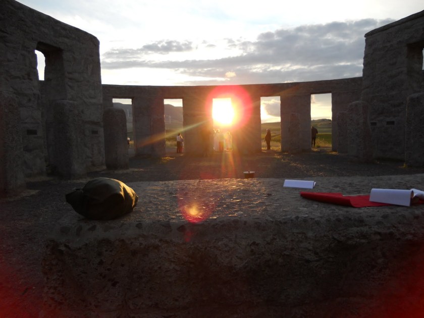
…it also has a nice alignment going on with the Milky Way, just like Stonehenge in England!

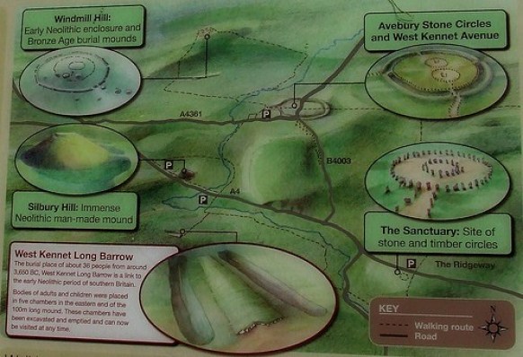
The Avebury Neolithic complex is located near Stonehenge, and it dated to the same time frame as Stonehenge and Watson Brake.

Today this is what is left of the standing stones…

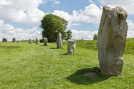
…of what was an ancient serpent temple.

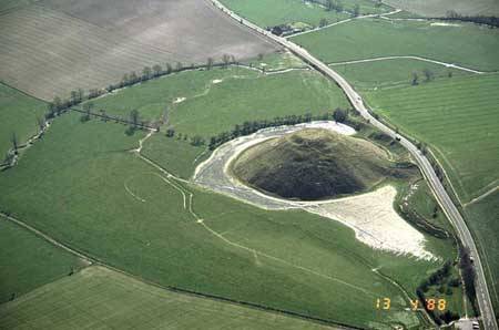
Silbury Hill is located near Avebury, and is called the tallest prehistoric, man-made mound in Europe, and one of the largest in the world.

Crop Circles frequently form in these locations in England.

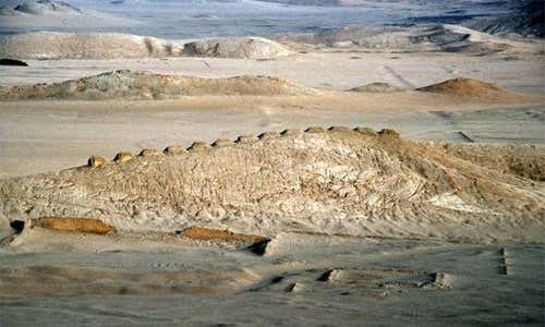
Serpent Mound in Peebles, Ohio, is the largest serpent effigy in the world.

It was first reported from surveys included in a book called “Ancient Monuments of the Mississippi Valley, published in 1848 by the Smithsonian Institution, and to this day has not been given a definite date of construction.

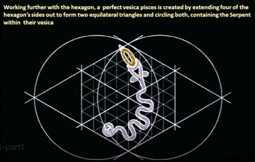
Serpent Mound has many astronomical alignments contained within its shape…

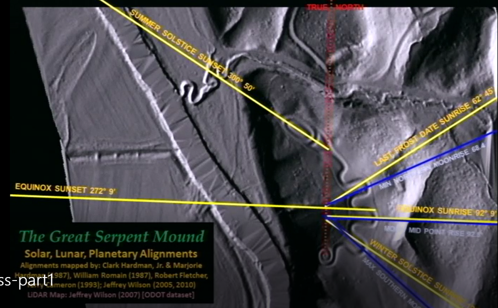
…as well as Sacred Geometry.

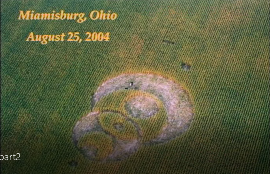
As with Silbury Hill near Avebury, the Miamisburg Mound in Miamisburg, Ohio, is located relatively close to the Serpent Mound…

…and crop circles in North America are found frequently in this part of Ohio.

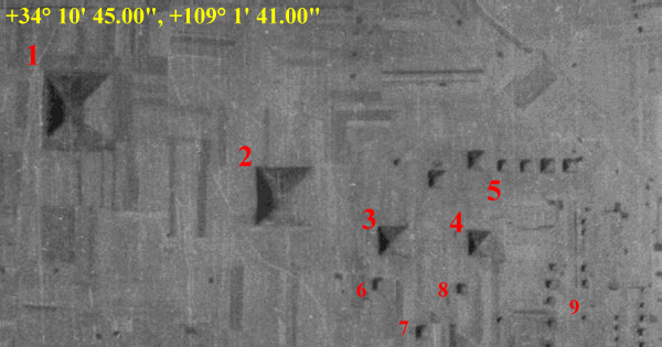
In Newark, Ohio, the Octagon and Great Circle Earthworks are located on a Golden Ratio Longitude, along with Poverty Point in Louisiana. Newark is 94-miles, or 150-kilometers, from Peebles, Ohio, where the Serpent Mound is located.

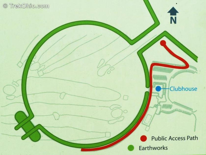
This diagram shows the lunar alignments marked by these earthworks in Ohio.

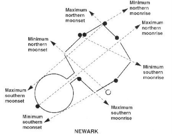
By the way, the Octagon and Great Circle of Newark…

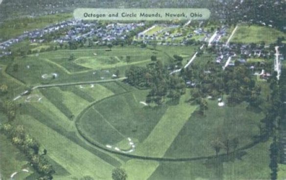
… are now part of the golf course of the Moundbuilders Country Club.

Another striking example of this practice by the Ancient Ones, of the consummate aligning of heaven and earth, is found near Forres, in Scotland.

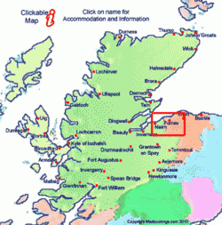
Forres is in the Grampian Mountains, which are said to have the highest concentration of stone circles found anywhere, and include what are called Recumbent Stone Circles, found only in this part of Scotland and in the far southwest of Ireland.

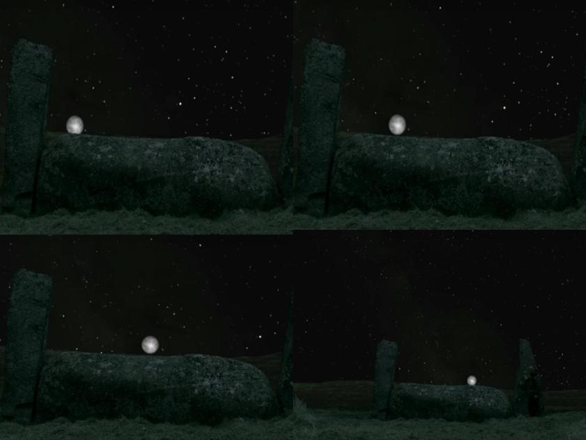
This is the Recumbent Stone Circle of Crowthie Muir near Forres. The center stone, weighing upwards of 50-tons, is perfectly placed in the landscape…

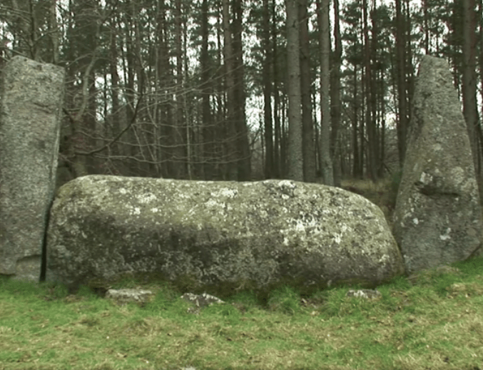
… for lunar events like this one, as the moon is seen rolling along the top of the recumbent stone on the same night.

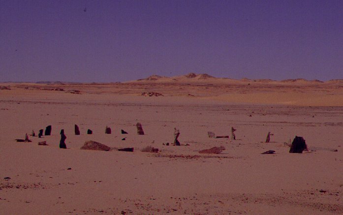
While the stone circles of Great Britain and Ireland are the best-known, there stone circles in many places, including in Africa, like the Bagnold Stone Circle in the Libyan Desert…

…the Mzora Stone Circle in Morocco…

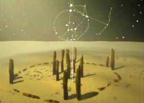
…and Nabta Playa, depicted with astronomical alignments, in southern Egypt, situated on the Tropic of Cancer.

Also on the Tropic of Cancer, Necker Island, part of the Northwestern Hawaiian Islands in the Pacific Ocean, is a relatively small island with over 30 stone temples and shrines.

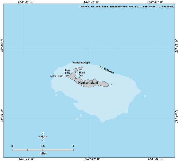
These have been studied by archeoastronomy experts for astronomical alignments.  This is a shrine on Necker Island…

…and a sketch of a temple platform there.

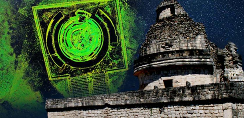
Famous early astronomical observatories include El Caracol, which is located in the Mayan archeological complex of Chichen Itza, located in Mexico’s Yucatan Peninsula.

It is dated to around 906 AD.

The Maya had a spectacular knowledge of astronomy; were skilled engineers; and had a mathematics which could calculate dates billions of years in the past and in the future.

When this observatory was being excavated, advanced design features were discovered that incorporated sophisticated knowledge about how to align the central observatory with the cosmos.

For example, designed into the outer terrace are two slots that follow the curvature of the tower, and which could have supported a viewing apparatus of some sort.

In China, the Gaocheng Astronomical Observatory is located in Dengfeng, in Henan Province.

The great observatory was said to have been built in 1276 to observe the movement of the sun, the stars, and to record time.

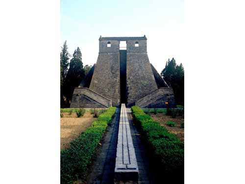
It has been listed as a UNESCO World Heritage Site since 2010 as the “Dengfeng Historic Monuments in the Center of Heaven and Earth.”

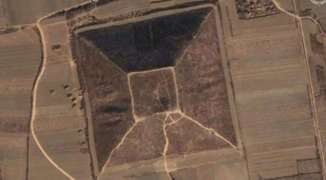
Dengfeng is due east of Xi’an, China, where…

…where a significant number of pyramids are located in China.

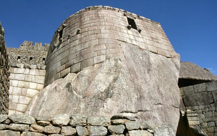
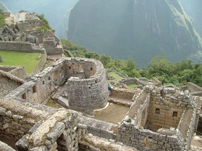
The Torreon, or Observatory, at Macchu Picchu in Peru is called a rare example of curved Inca architecture, incorporating natural features into its design.

It was said to have been built in 1450 AD.

It was placed inside the Temple of the Sun at the highest altitude of Macchu Picchu.

The tower is built around a stone with a curved groove that is illuminated as the rising sun shines through one window on the June solstice.

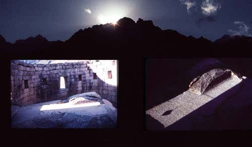
Around this same time, this window frames the Pleiades star cluster…which we are told was used by the Incas to determine when to plant potatoes. Sounds like incredibly sophisticated astronomical engineering to only serve as an almanac in stone!!!

The ancient observatory in Chankillo, Peru, said to date back to 300 BC…

…has thirteen regularly-spaced towers…

…where you can see the sun rise and set in gaps between the towers, with the sunrise moving back and forth across the whole structure in a year.

Now on to what would be considered more modern observatories.

We are told The Royal Observatory in Greenwich, England, was commissioned in 1675 by King Charles II, and the site on Greenwich Hill chosen by architect and astronomer Sir Christopher Wren.

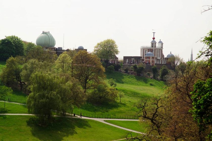
The building of the observatory was then completed in the summer of 1676.

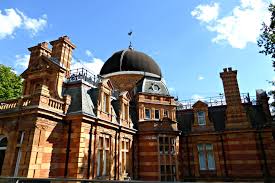
It has been the location of the world’s Prime Meridian since 1851.

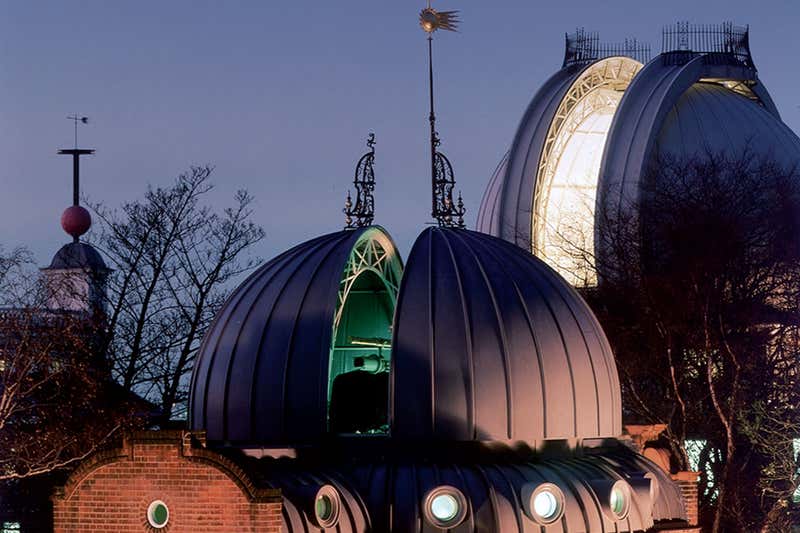
The time-ball at the Royal Observatory at Greenwich is said to have been in use since 1833.

Every day, the ball rises half-way up the mast at 12:55 pm Greenwich Mean Time, up to the top at 12:58 pm…

…and drops exactly at 1 pm.

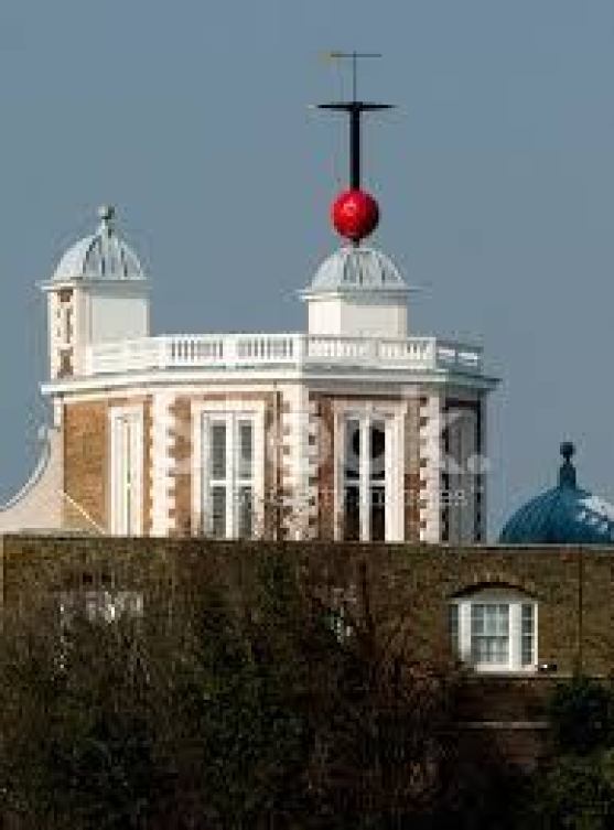
We are told this practice was established in order to have a standardized way to mark time for naval ships and the citizenry.

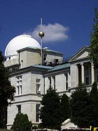
The United States Naval Observatory, located in Washington, DC, is said to be one of the oldest scientific agencies in the United States.

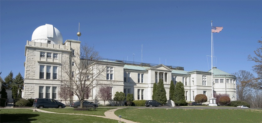
The Naval Observatory maintains the Master Clock for the United States.

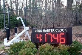
There is also a time-ball here, said to have been installed in 1845, and dropped every day, enabling the inhabitants of Washington to set their time-pieces.

Since I believe that all of these observatories were built by the advanced, ancient civilization, I don’t believe the their original purpose was to synchronize the time in this manner.

My speculation as to what their actual function would be goes in the direction of an astronomical function, like the function of sun daggers, since this civilization completely revolved around the perfect alignment of Heaven and Earth.

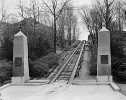
There is an example of a sun dagger at Fajada Butte in Chaco Canyon in New Mexico.

There are three large stone slabs there leaning against the cliff which channel light and shadow markings on to two spiral petroglyphs in the cliff wall that form daggers of light at solstices and equinoxes.

What if instead of measuring linear time, time-balls were a way to measure astronomical time, and instead of dropping quickly in mere minutes, were dropped very slowly to measure astronomical time?

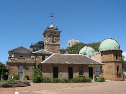
Other places with time-balls include the Sydney Observatory in Australia…

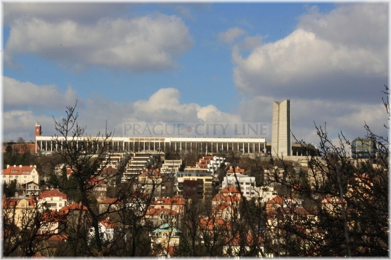
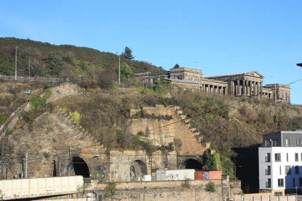
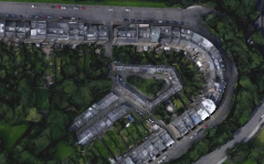
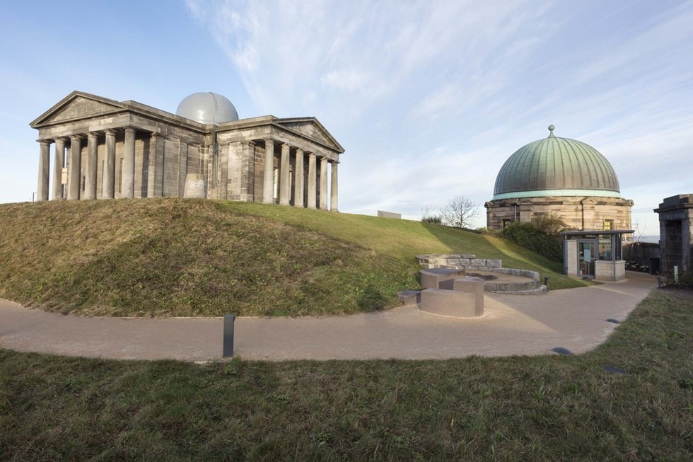
…the Nelson Monument on the highest point of Calton Hill in Edinburgh, Scotland, which is right next to…

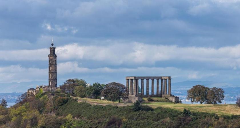
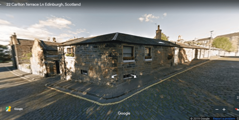
…the City Observatory of Edinburgh…

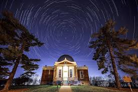
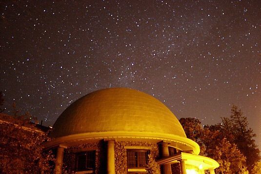
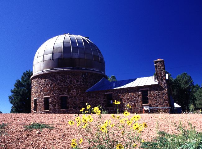
…the Cincinnati Observatory at one point in time had a time-ball…

…but apparently not anymore…

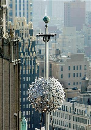
…and the time-ball in Times Square, which gets dropped once a year to usher in the New Year.

In an interesting aside, the United States Naval Observatory also has a station in Flagstaff, Arizona, for national dark-sky observation.


The Lowell Observatory is also in Flagstaff…

…and as well, the Atmospheric Research Observatory on the campus of Northern Arizona University in Flagstaff.

In taking this tour through time, I wanted to share with you the absolutely stunning accomplishments of Our Ancestors, impeccably aligning the physical infrastructure of the earth with heavenly bodies and astronomical events, and accurately keeping track of everything going on up above via observatories, watching, recording, and predicting larger cycles of time to keep Humanity in synchronization with each other and the Heavens.

In my next post, I will be looking at disputed islands around the world.

Going Deep into Underground Railway Systems

I decided to look deeply into the subject of underground railway systems when I kept coming across the fact that the railway stations of major cities are transportation hubs for all ground-based mass transit systems, including not only trains, but trams, underground rail systems, and buses.

All of these transportation inter-connections are part of an incredibly complex topic, of which I can only scratch the surface. As I read through the history of rail-lines, it is hard to process and digest all of the information because there is so much there. Beginnings, and then consolidation, and first it was called this, and then it was called that, and then it was taken over, and more consolidation, and so on. It is hard for me to even describe it. Look into it some time, and you will quickly see what I mean. Rapid-fire data points!

I will start in London, at the address of 55 Broadway, where the headquarters of the London Underground, and called London’s first skyscraper, said to have been built between 1927 and 1929.

It is interesting to note its location in London is just blocks away from the seat of British government ~the Palace of Westminster which houses the British Parliament; 10 Downing Street, the residence of the Prime Minister; and near Westminster Abbey, the traditional place of coronation, marriage, and burial for British monarchs.

Here you see what looks like old masonry at the 55 Broadway location.

The building is said to be faced with limestone from the quarries of the Isle of Portland, just off the coast of England…

…where we find megalithic-looking stone blocks lying all around.

The cruciform-, or cross-, shaped building at 55 Broadway was said to have been designed by Charles Henry Holden, and his Underground station designs were said to have become the London Underground Corporation’s standard design in the 1930’s.

In 1902, Holden was said to have won the architectural competition to design the Bristol Central Library, which opened in 1906…

…in 1906, he won the competition to design a new Headquarters for the British Medical Association on the Strand in London, said to have been built in 1907 and 1908…

…which is now the Zimbabwe House, the Embassy for Zimbabwe.

…and in 1909, we are told he won the competition for designing an extension to the British Royal Infirmary, said to have been built in 1911 and 1912.

The London Underground Headquarters he was given the credit for designing sits on top of the St. James Underground Station, said to have opened on December 24th, 1868.

The London Underground is said to be the oldest underground railway system in the world.

We are told the idea of an underground railroad linking the City of London with the urban center came up in the 1830’s, and in 1854, the Metropolitan Underground Railway was granted permission to build it.

Operations were said to have started in January of 1863 between Paddington and Farringdon, using gas-lit wooden carriages hauled by steam locomotives.

Does that sound plausible? And gas-lit carriages underground? What about ventilation? Would this need have been accounted for in the mid-1800’s according to the history we have been taught?

Fast forward to the establishment of the Underground Electric Railways Company of London (UERL) in 1902 in order to finance and operate three tube lines – the Baker Street and Waterloo Railway…

…the Charing Cross, Euston, and Hampstead Railway…

…and the Great Northern, Piccadilly and Brompton Railway.

This was the Lots Road Power Station, said to have been built between 1902 and 1904 to power the newly created Great Northern, Piccadilly, and Brompton Line.

It was claimed to be the largest power station ever built, and eventually powered most of the railways and tramways in the Underground Group.

So we aren’t even out of the horse-and-buggy era when it was said to have been opened in 1904, with the mass production of automobiles not starting until 1908 with the Model T Ford, and yet we have the technology to build sophisticated electrical machinery generation like this?

And there are still places in the early 1900’s that use horses to pull rail cars along their tracks? What is going on here?

Not only that, there are a lot of abandoned underground tunnels and stations in London, not in use for a very long time. Why build them to then not use them?

This is an abandoned tunnel at Down Station…

…at Highgate Station…

…and Clapham South Station.

These are just a few examples, and London is not the only place with abandoned tunnels.

I also found a listing of former stations served by a London Underground line showing that around 50 have been permanently closed, and either demolished, or re-purposed, starting as early as 1871. The original Westbourne Park Underground Station was said to have been built in 1866 and demolished in 1871, replaced the next day by the current station shown here, to the east of the original.

Compare the similarity of the arches of the Underground Station in Westbourne with the arches of the Mezquita in Cordoba, the capital of Moorish Spain.

This is a map of the London Underground presented by Harry Beck, an engineering draftsman, in 1931.

His design is based on the principle of electrical circuit diagrams.

Power circuits transfer and control large amounts of electricity.

Could the builders of the London Underground have possibly created gigantic power circuitry, starting in a haphazard way in 1854 onward, with the creation of the Metropolitan Underground Railway?

In Hungary, Budapest is said to have the second-oldest underground railway system in the world, and the oldest electrified railway system, with the M-1, or the Millenium Underground Railway, said to have been in operation since May 2nd, 1896.

We are told the original purpose of the first metro line was to facilitate transport to the Budapest City Park along Andrassy Avenue without building surface transport affecting the streetscape…

…running from Vorosmarty Square, the city center…

… to Budapest’s City Park.

The Szechenyi Medicinal Bath is in an extensive City Park Complex, and is the largest medicinal bath in Europe. Its construction was said to have started in 1909, and opened in 1913.

The M-1 underground line was said to have taken two years to build, between 1894 and 1896, by the German engineering firm Siemens and Halske AG, founded in 1847 by Werner von Siemens and Johann Georg Halske.

Just as a side-note, the Siemens and Halske AG company was also given the credit for the world’s first electric tram line, the Gross-Lichterfelde Tramway, in a suburb of Berlin.

This brings the total to three of places that I have found in my research claiming that distinction, the other two being Montgomery, Alabama, and Sestroretsk, in Russia near St. Petersburg.

Altogether, there are four lines in Budapest, each denoted by a different color.

I am going to put this here for consideration as a possibility. When I looked into electric circuitry, I found the same colors, with each having a different function in circuitry. We will see more examples of this correlation in other systems. They feature exactly the same colors.

I am postulating that these electric transportation systems and networks somehow functioned as electrical circuits in their own right in the original physical lay-out of the planetary grid system, and do not just pertain to the sophisticated electrical circuitry it takes to run them efficiently, day-in and day-out.

Before I leave Budapest, I want to bring to your attention that it is called the capital city of underground wonders.

Besides abandoned rail tunnels…

…there’s what is known as the Kobanya Cellar System…

…and the underground labyrinth of Buda Castle.

This half-head is found in the labyrinth. I find it to be extremely odd…and noteworthy. It looks more like a petrified head, covered up to the nose and ears by mud, than an intentional work of art.

We are told that Glasgow in Scotland has the third-oldest underground rail system in the world, opening on December 14th, 1896.

The fifteen stations of the subway are distributed over a 10-kilometer, or 6-mile, circuit of the West End and City Center of Glasgow, with eight stations to the north of the River Clyde, and seven to the south. There are two lines: an outer circle running clockwise, and an inner circle running counter-clockwise.

Circuit is a word in the English language that means: 1) a roughly circular line, route, or movement that starts and finishes at the same place; and 2) a path in which electrons from a voltage or current source flow. The point where those electrons enter an electrical circuit is called the source of the electrons.

This came up when I searched for “particle accelerator diagram,” showing counter-rotating beams in a circular accelerator, contrasted with the Glasgow subway’s outer and inner circle running in opposite directions from each other.

There are also abandoned rail-line stations in Glasgow, like the Botanic Gardens Station, said to have been built in 1896, and closed to passenger transport in 1939…

…and the abandoned tunnel at the Botanic Gardens in Glasgow as well.

Again, why build heavy infrastructure like this to close it after only 45-years of use?

Next, here are maps underground systems of places throughout the world.

Berlin, Germany…

…Hamburg, Germany…

…Helsinki, Finland…

…St. Petersburg, Russia…

…Sydney, Australia…

…Beijing, China…

…Tokyo, Japan…

…New York City…

…Los Angeles, California…

…and Washington, DC, to name a very few.

While not identical lay-outs in all these places, there are definite similarities across countries and continents in how rail-lines are laid out, right down to color-coding all of them.

And they all look remarkably like an electrical circuit diagram.

I am going to end this post here. I have only scratched the surface of the earth’s subterranean infrastructure. When there is an overwhelming amount of information, I try to hit highlights.

In my next post, I am going to be looking at the topic of astronomical observatories, from ancient to modern.

The Incredible Similarity of Electric Tram Systems Worldwide

In my research, historical tram systems, also known as streetcars, keep cropping up.

I started to notice a close connection between not only trams, trains, canals, and star forts, but the incredible similarity between these systems all over the world.

I will start with one of the first one I came across in my research, which is in a seemingly unlikely place based on what we have been taught, and go from there. There are so many examples that I will select notable ones for the purposes of this post. There are too many to include them all.

In South America, Manaus is a remote city in the heart of the Amazon Rainforest in Brazil, and is, for all intents and purposes, accessible only by boat or plane.

We are told the city was founded in 1669 by the Portuguese as the “Fort of São José do Rio Negro,” and was renamed Manaus, after the indigenous Manaos people, in 1848 when it was established legally as a city. This is a depiction of the star fort that used to be there.

It became the capital of Brazil’s Amazonas Province in 1850.

The historical narrative we are given says that rubber made Manaus the wealthiest city in South America in the late 1800s, and wealthy European families are said to have settled in Manaus, bringing their European art, architecture, and culture with them. It was a city at that time with electric trams and streetlights.

Electric trams and streetlights?

In the middle of the Amazon rainforest?

No road connection to Manaus existed until 1973, with the completion of the BR-319, connecting Manaus to Porto Velho, Brazil. It is 540 miles long, or 870 kilometers, going through the rainforest, and is impassable when it rains. It is known as Brazil’s worst highway.

There is no such tram system operating in Manaus today.

The history we have been taught does not provide an adequate explanation for what was really going on here. This is a photo of undeveloped Amazon rainforest near Manaus. How are they supposed to have built all of this in the mid-to-late 1800’s under these conditions?

In North America, Montgomery, Alabama, is one of the places we are told was the first place in the world said to have had a city-wide system of electric trams established in 1886, known as the “Lightning Route.”

The technology for this was said to have been developed by Belgian-American inventor Charles Joseph Van DePoele, who was born in 1846, and died in 1892.

He was credited with the development of electric railways, with his first being established in Chicago in 1883.

Prior to this time, rail-lines were said to have been in existence since the earlier in the 1800s with locomotion provided by either steam-engine or horse.

For some reason, the “Lightening Route” in Montgomery only operated for 50 years, when in 1936, the streetcars were retired in a big ceremony and replaced by buses.

We are also told that the world’s first electric tram system was developed in 1880 by Fyodor Pirotsky, born in 1845 and died in 1898…

…and tested in Sestroretsk, near St. Petersburg, Russia, in 1880.

I have consistently found forts, castles, and other significant and ancient sites in the vicinity of railways and tramways.

This is Fort Negley in Nashville, Tennessee, with rail-lines close to it, on the other side of the baseball field.

I am really curious about why a baseball field is located right next to the star Fort Negley, and perhaps someday will research the real possibility of a connection of ball-fields, and other athletic fields, to the ancient advanced civilization.

The extensive electric tram system in Nashville ran from 1889 to 1941.

Some cities kept their electrically-power mass transit tram systems in operation. But many did not. Why build the sophisticated infrastructure, and then only use it for fifty or so years?

In Indiana, the Terre Haute, Indianapolis, and Eastern Traction Company was formed in 1907, and the second-largest interurban in Indiana, a type of electric railway with over 400 miles of track.

It was incorporated into the Indiana Railroad in 1931.

I looked to see what was in this area in the way of forts, and found Fort Harrison near Terre Haute. It is typically depicted as a wooden structure like this.

I found this post card, however, showing the Pavilion Entrance to Fort Harrison as having a masonry structure.

And here’s what is left of it on the grounds of Fort Harrison State Park.

In Europe, this is the Petrin Funicular in Prague in the Czech Republic.

It links the Mala Strana District with the top of Petrin Hill, which overlooks the old city of Prague…

…where there is a look-out tower that looks a lot like the Eiffel Tower in Paris, and said to have been built in 1891 for the Jubilee Exhibition held in Prague – also known as the General Land Centennial Exhibition.

This was the same year the Prague’s electric tram system was said to have been established.

Stefanik Observatory is also on Petrin Hill…

…as well as Strahof Monastery.

The Prague Castle is a castle complex said to have been built starting in 870 AD, and a seat of power for the kings of Bohemia, Holy Roman Emperors, and the presidents of Czechoslovakia since 1918.

The crown jewels of Bohemia are also kept in Prague Castle.

These are power objects in their own right. But that’s another story that I don’t know much about. I just know royal objects such as these are specific power instruments for the ruler.

The Prague Castle complex is close to both Petrin Hill area…

…and the Great Strahov stadium can be accessed by the funicular or several of the tram-lines.

It is the largest stadium in the world, with a capacity to have 250,000 spectators. It is a UNESCO Cultural Heritage site.

When I was researching Edinburgh for “How Monuments and Memorials Hide the Advanced Ancient Civilization,” I noticed railroad tracks at the base of Calton Hill.

There is a great deal to see on Calton Hill, the seat of Scottish Government, and among other things, it is the location of the Edinburgh City Observatory, like the Stefanik Observatory on Petrin Hill in Prague.

Edinburgh Waverley Train Station is at the base of Calton Hill…

…and this is what it looks like on the inside.

There are actually railroad tunnels going right through Calton Hill.

I noticed a pentagonal shape in a neighborhood on top of Calton Hill…

…which turns out to be the Carlton Terrace Mews, a residential neighborhood said to have been designed by the Greek Revival architect William Henry Playfair in the 1820s.

Here is the pentagon formed by the Carlton Terrace Mews on the left, compared with Fort Cunningham on the island of Bermuda on the right.

Edinburgh Corporation Tramways were said to have operated between 1871 and 1956, using double-decker trams.

In Asia, Hong Kong Tramways began operating in 1904, and owns the world’s largest operational double-decker tram fleet, and the system there is in use in the present day.

I looked into whether or not there were any star forts in Hong Kong.

There is a Fortress Hill in Hong Kong, on the North Shore of Hong Kong Island, served by the Hong Kong Tramways, and the rapid transit railway of Hong Kong, the MTR.

The North Point Power Station was located near Fortress Hill, and was severely damaged during the World War II Battle of Hong Kong just prior to the Japanese occupation of Hong Kong, which started on December 25th, 1941. Check out the big, megalithic-looking stones in this picture of North Point in 1941.

Beijing was said to have had the first tram system in China, opening in 1899.

I found Wanping Castle in Beijing, located right next to railroad tracks.

Also called Wanping Fortress, and Wanping Ancient Town, it is called a Ming Dynasty walled city that was built between 1638 and 1640.

Now I am going to show you other tram systems around the world without going into detail.

In Africa, in Alexandria, Egypt…

…Melbourne in Australia…

…Hobart in Tasmania…

…in Pyongyang, North Korea…

…in Seoul, South Korea…

…in Hanoi, North Viet Nam…

…in Saigon, South Viet Nam…

…in Moscow, Russia…

…in Augsburg, Germany…

…in Leeds, England…

…in Montreal, Quebec, Canada…

…in Rio de Janeiro, Brazil…

…and back in the United States, in New Orleans, Louisiana…

…in Charlotte, North Carolina…

…and here’s another one in a quiet residential neighborhood in Charlotte…

…and in Denver, Colorado, to name just a few.

One more thing before I end this post is to touch base on the cultural phenomenon of “Trolley Parks,” which were said to have been started in the United States in the 19th-century at the ends of street car lines in most of the larger cities, and said to be the precursor of amusement parks.

I feel I would be re-miss if I didn’t include trolley parks in this post. Look closely at the style of the architecture in the following pictures.

Coney Island in New York was one of them.

I learned about trolley parks when I was doing research on Palisades Park in New Jersey.

This is a view of the roller coasters at Palisades Park from the trolley terminal at Edgewater, New Jersey, with the photo taken in the early 1900’s.

Some other historical trolley parks were the Idora Park in Oakland, California…

…and Ramona Park in Grand Rapids, Michigan.

The people who said they built all of this weren’t the people who built it. The collective memory of the ancient and advanced Moorish Civilization is almost completely gone from our historical narrative, with the exception of Moorish Spain. Look at the incredible infrastructure of the Electric Park in Kansas City, Missouri…

…and said to have been built and closed between 1907 and 1925.

In my next video, I will be finishing up the subject of worldwide transportation systems by looking at underground rail systems.

Correlations Between the Physical Infrastructure of Railroads, Canals & Star Forts and Other Interesting Things

I am finding many interconnections in my research with regards to what I am sharing about the ancient and advanced Moorish Civilization that is missing from our historical record.

There are definitely correlations and relationships between railroad systems, canal systems, and star forts as you will see.

Pay close attention to the dates when they are telling us this infrastructure was built, and compare those dates with what we are taught in the historical narrative we have been given, i.e. were we really capable of accomplishing these massive engineering feats such as these during the time period they were said to have been built?

This is just a dip in the pool of information on this topic, as there is such an overwhelming amount of data concerning even just railroads and their associated infrastructure that I find myself having to focus the scope of this post, and not include much of what I originally envisioned. There is just too much information to choose from!

The history of rail transportation in North America was said to have started with the construction of wooden railroads, called wagonways, starting in the 1720s.

The French were said to have used a railroad in its construction in 1720 of the Fortress of Louisbourg on Nova Scotia’s Cape Breton Island.

Between 1762 and 1764, an efficient gravity-railroad called Montresor’s Tramway was said to have been designed and built by British engineers at the close of the French and Indian War (1756 – 1763) to haul goods up the steep slope at the Niagara River near the Niagara Falls escarpment at Lewiston, New York.


As an interesting aside, compare the Niagara Escarpment in appearance with…

…the Endless Wall at New River Gorge State Park in West Virginia.

In 1810, the Scottish-American quarry-owner Thomas Leiper was said to have built the animal-powered Leiper Railroad connecting Crum Creek to Ridley Creek in Delaware County, Pennsylvania, to carry his quarried stone to tide-water. It was said to have been a horse-drawn, 3/4-mile, railroad. It became the Crum Creek Branch of the Baltimore and Philadelphia (later part of the Baltimore & Ohio) Railroad in 1887. More on the Baltimore & Ohio Railroad shortly.

Then, Thomas Leiper’s son was credited with building the 3-mile long Leiper Canal to replace the Leiper Railroad in 1828 and 1829…

…in the middle of what was called the American Canal Age between 1790 and 1855, when the Lehigh Canal was built between Easton, Pennsylvania and Mauck Chunk, now known as Jim Thorpe, Pennsylvania, said to have been started in 1818, and completed in 1838…

…during which time the Schuylkill Canal, also known as the Schulkill Navigation, was said to have been built in Pennsylvania between 1815 and 1825…

…as well as the 82-mile, or 132-kilometer, Union Canal in southeastern Pennsylvania between Middletown, Pennsylvania to Reading, Pennsylvania, said to have been built between 1792 and 1828, and closed in the 1880s. This is the Union Canal Tunnel in Lebanon, Pennsylvania…

…and what remains of the Union Canal at Swatara State Park near Lickdale, Pennsylvania…

…the 14-mile, or 22.5-kilometer, long Chesapeake and Delaware Canal, connecting the Delaware River in the State of Delaware, and the Chesapeake Bay in Maryland, with its construction said to have been started in 1804 and completed in 1829…

…as well as the 363-mile, or 584-kilometer, long Erie Canal, connecting the Hudson River in Albany, New York, with Lake Erie in Buffalo, New York, with construction beginning on, and first used on May 17th, 1821.

The construction of the Erie Canal was said to have started on July 4th, 1817, in Rome, New York, where Fort Stanwix, said to have been built in 1758 by the British, was located.

The New York Central Railroad, primarily operating in the Great Lakes and Mid-Atlantic Regions, had a train station in Rome.

The New York Central Railroad was said to have begun operating in 1853 with the consolidation of earlier independent companies running between Albany and Buffalo. This graphic depicts the New York Central rail system as of 1918.

We are told extensive trackage existed in the states of New York, Pennsylvania, Ohio, Michigan, Indiana, Illinois, Massachusetts, and West Virginia, plus additional trackage in Ontario and Quebec, and by 1925 operated 26,395-miles, or 42,479-kilometers, of track.

Now, back to railroads circa 1826.

In 1826, the State of Massachusetts incorporated the Granite Railway in Quincy, Massachusetts…

…as a common freight carrier to transport Granite for the construction of the Bunker Hill monument, which was said to have commenced in the same year of 1826, which just happens to be a huge obelisk on the scale of the Washington Monument.

Other railroads authorized by states in 1826 included the Delaware and Hudson Canal Company’s gravity railroad…

…the Mohawk and Hudson Railroad, to carry freight and passengers, and linking the Mohawk River in Schenectady, with the Hudson River at Albany…

…and said to have been the first railroad chartered in the country, incorporated in 1826 and opened in 1831.

In 1827, the State of Maryland chartered the Baltimore and Ohio (B & O) Railroad, the first common carrier, and the oldest, railroad in the United States.

The first section of the B & O Railroad was said to have opened in 1830, and it was said to have reached the Ohio River in 1852, the first eastern seaboard railroad to do so.

We are told there was an intense rivalry between the B & O Railroad, and the Chesapeake & Ohio (C & O) Canal, with each project choosing the same day to break ground – on July 4th, 1828.

Both projects were said to be vying for the narrow right-of-way where the Potomac River cuts through a mountain ridge at Point of Rocks, Maryland, which ended up in court. Even though after four-years the case was said to have been ruled in favor of the canal, we are told the C & O had to allow the
B & O to go through there, so this is a place where the canal and the railroad run side-by-side…

…just like the picture I showed earlier of the railroad right next to the Lehigh Canal in Bethlehem, Pennsylvania.

Similar to the B & O Railroad, the South Carolina Canal and Railroad Company was also chartered in 1827 to connect Charleston, South Carolina, to the Savannah River, and its first six-mile, or 10-kilometer, rail line was said to have been in operation by 1830…

…and ran scheduled steam service over its 136-mile, or 219-mile, line from Charleston to Hamburg, South Carolina, beginning in 1833.

This was the historic Camden Depot in Charleston, said to have been built by the South Carolina Railroad in 1849 and 1850 by architect Edward C. Jones.

In my research of the South Carolina Canal and Railroad Company, I am seeing all railroad-related information, and no canal-related information.

So I looked up canals in South Carolina, and this is what I found, so obviously there were canals in South Carolina, but hardly any clarity on who actually built them, nor is there much information available about them.

This is one of several star forts that were located in the Pensacola, Florida area.

This is the former location of what was called the fort of Pensacola…

…where the CSX Railyards are just a few blocks south of where the fort was located.

At one time, this was part of the Pensacola Railroad System that was completed in 1860.

By the year of 1850, there were 9,000-miles, or 14,000-kilometers, of railroad lines said to have been built in the United States.

We are told that the federal government operated a land-grant system between 1855 and 1871, where new railway companies in what we are told was the uninhabited west were given millions of acres they could sell or pledge to bondholders.

The establishment of a land-grant system at this time is a good place to insert once again the story of the Ames Brothers of Easton, Massachusetts, co-owners of the Ames Shovel Shop, nationally known for providing the shovels for the Union Pacific Railroad, which we are told opened the west. It was said to have been the world’s largest supplier of shovels in the 19th-century.

Not only that, one brother, Oliver Ames, Jr, (b. 1807 – d. 1877) was the President of the Union Pacific Railroad from when it met the Central Pacific Railroad in Utah for the completion of the first Transcontinental Railroad in North America.

The other brother, Oakes Ames, was a member of the U. S. Congress House of Representatives from Massachusetts 2nd District from 1863-1873. He was credited by many as being the most important influence in building the Union Pacific portion of the first Transcontinental Railroad.

Oakes Ames was also noted for his involvement in the Credit-Mobilier Scandal of 1867, regarding the improper sale of stock of the railroad’s construction company.

He was formally censured by Congress in 1873 for this involvement, and he died in the same year.

Ten-years later, he was posthumously exonerated by the Massachusetts State Legislature on May 10th, 1883.

This is the Ames Monument near Laramie in Wyoming, said to have been built between 1880 and 1882. It was dedicated to the Ames brothers for their role in financing the Union Pacific Railroad. Hmmm…serious conflicts-of-interest and graft much, but no real consequences to their memory?

There is one more U. S. railroad that I would like to take a look it before moving on, which is the Gulf and Ship Island Railroad in Mississippi, with the reason given for its construction being the opening a vast expanse of southern yellow pine forests for commercial harvest.

It was said to have been developed under three charters provided by the Mississippi State Legislature, with the first charter being granted in 1850, a second one in 1856, and the last one in 1887, and the Gulf and Ship Island Railroad was opened in 1882, with Gulfport, Mississippi being the railroad terminal and headquarters.

What is really interesting to me that while there is a deep-water harbor protected by Ship Island, in the Gulf of Mexico just off the coast of Mississippi, there is also a star fort – called Fort Massachusetts, said to have been built following the War of 1812.

Onward to Canada.

The Champlain & St. Lawrence Railway was the first Canadian railway, chartered in 1832 and built in 1835. It was said to have been financed by Montreal businessman & brewery owner John Molson.

It ran for a distance of just over 14-miles, or 23 km, starting operation on 21 July 1836, and linking Laprairie, a city across the St. Lawrence River from Montreal, to St. John on the Richelieu River, to cut time from the trip between Montreal and New York.

A Stephenson Samson steam locomotive pulled two coaches on a round-trip from Laprairie.  In 1851 an extension was added to this rail line to Rouses Point in New York.

Canada’s Grand Railway Hotels were said to have been built by the Canadian Railway companies, with the development of the railways said to have acted as the catalyst for their construction. The use of towers and turrets were said to be a signature style for Canada’s majestic hotels. It is important to note that towers and turrets are a signatures of Moorish architecture.

Right next to the main train station of Montreal, the Windsor station, said to have been built between 1887 and 1889…

…was the Windsor Hotel in Montreal, the first Grand Railway Hotel , said to have been built in 1878.

Compare the appearance of the Windsor Hotel in Montreal with that of the Westin Palace Hotel in Madrid, Spain, where the Moors do have an historical presence.

Other Canadian Grand Railway Hotels include:

The Second Hotel Vancouver, said to have been built by the Canadian Pacific Railway between 1912 and 1916 (keeping in mind World War I was between 1914 and 1918)…

…and the Chateau Frontenac in Quebec City, said to have been built by the Canadian Pacific Railway between 1892 and 1893…

…which reminds me of the Ksiaz Castle in Poland, said to have been built between 1288 and 1292.

Now, other historic train stations around the world include:

The Tokyo Station in the Marunouchi District of Tokyo, Japan, which was said to have opened in 1914…

…and here it is today, with a fair amount of the original buildings still intact..

Here is the Amsterdam Central Railway Station, said to have been built starting in 1882 and opened in 1889…

…and the Gare d’Orsay in Paris, said to have opened in 1900…

…and the caption of this photo of inside this railroad terminal reads “Electric trains operating in the Gare d’Orsay, circa 1900.”

This leads me to look up the definition of terminal, for which there are two nouns:

  1. The end of a railroad or other transportation route, or a station at such a point
  2. A point of connection for closing an electric circuit

I believe we are talking about a sophisticated electrical circuitry system that the Master Builders of the Ancient & Advanced Civilization built into the physical infrastructure of the planetary grid system, and accessed free energy to provide electrical power for this civilization worldwide, including all transportation systems.

One more thought in closing. I came across this a picture of this painting called “The Excavation of Pennsylvania Station,” painted by George Wesley Bellows in 1909, in New York City.

While it could certainly mean the act or process of digging in and of itself, it has a subtler meaning associated in archaeology with removing something specific from the ground to find artifacts. So, what kind of excavation are we seeing here? There are some interesting things going on here, to include what looks like tracks of some kind in the left mid-ground.

This is the original Pennsylvania Station in New York, said to have been built between 1905 and 1910…and demolished in 1963. Why build a massive building of heavy masonry and demolish it after only 53 years of use? This makes no sense, and was the fate of many of these original railroad terminals.

I personally think all of this infrastructure was being dug out of the mud created by a world-wide liquefaction event that took place around 1740 – 1741, and that Humanity’s new historical narrative was kicked-off in 1851 with the Great Exhibition held in the Crystal Palace in London. I didn’t start from this perspective. I have come to this conclusion from my research. Even in this post, there are a lot of things happening in the time-frame around the date of 1850.

In my next post, I am going to look closely at the related subject of streetcar systems around the world.

Sault Ste. Marie – A Microcosm of the Advanced & Global Moorish Civilization

When I was researching “The Manner in which a Global Canal System has been Kept from Our Awareness,” I searched for the Sault Ste. Marie Locks. I already knew they were impressive from earlier research into what is the hidden history of not only North America, but of the World.

When this photo with detailed information popped up of what are called the “Soo Locks,” I knew I was looking at a significant complex with respect to the hidden Advanced Ancient Civilization, and was instantly interested in taking a closer look at the area. I got a “Ding, ding, ding, Jackpot!” vibe in my head. Even in my initial foray into research here for this post, I found much to reveal. It seems to have everything Moorish rolled into one place!

The Soo Locks, the largest waterway traffic system on Earth, are called the “Linchpin of the Great Lakes,” allowing ships to travel between Lake Superior and the lower Great Lakes. Lake Superior meets Lake Huron with a 21-foot drop in elevation.

I am usually not interested in what the historical narrative says, except for the purpose of finding specific physical locations and landmarks for my research, but I think it is important in this case to share a few things about what we are taught in our historical narrative about this location.

The city of Sault Ste. Marie was said to have been founded by the French Jesuit missionary, Father Jacques Marquette, in 1668. It was said to be named for both the “Sault,” the name given to the St. Mary’s River rapids, and the Virgin Mary, and called the first European city in the Great Lakes Region.

We are told that before the coming of Father Marquette, and “civilization,” this land was inhabited by the Anishinabeg, or Anishinaabe, a name the Ojibwe and Algonquin people use for themselves in their own language, meaning “original people.”

When I searched for a map of where the Algonquin peoples lived in North America, and this is what comes up.

I will be bringing together different strands of this fabric by showing you what is actually here as we go along to weave a different picture of history based on physical evidence, and the inconsistencies in what we are told about it.

Sault Ste. Marie was one city until the border between the United States and Canada was established at the St. Mary’s River in a treaty after the War of 1812, creating Sault Ste. Marie, Michigan, and Sault Ste. Marie Ontario, and on both sides of the river, the area is referred to as the “The Sault” or even “The Soo.”

Sault Ste. Marie is the oldest city in Michigan, and said to be the third-oldest city in the United States.

The main course of the St. Mary’s River, starts at Whitefish Bay at the eastern end of Lake Superior, and flows 74.5-miles, or 119.9-kilometers, southeast around Sugar Island into Lake Huron.

At the River of History Museum in downtown Sault Ste. Marie, Michigan, where we find out that St. Mary’s River is 8,000-years-old, and “born out of the trauma of this land as it buckled and ruptured, and gave way amidst thunderous sound and gigantic force – carved and formed by nature’s relentless sculptor – the glacier. So, let’s take a look like what this violently-formed, nature-carved river looks like.

Before the St. Mary’s River even comes to the Lock Systems, from the direction of Lake Superior, this is what the shore-line looks like on the Ontario-side, with points and straight-edges…

…and even another canal going up into the city as pointed out by the arrows, with the last arrow showing where it looks like the canal was cut-off and drained.

The St. Mary’s River also has a so-called branch going into what is called Lake Nicolet on the other side of Sugar Island. Here is a close-up of what it looks like heading in that direction.

I am going to use the same graphic that I showed at the beginning as a means for organizing the information about this physical location.

I am going to start looking first around Sault Ste. Marie, Michigan on the right side, and work my way across the various features to Sault Ste. Marie, Ontario on the left side.

Brady Park is situated to the east of the Soo Locks on the St. Mary’s River waterfront…

…and were the grounds of the Old Fort Brady. Here we find an obelisk said to have been designed by Charles McKim, of what is called the renowned New York architecture firm McKim, Mead, and White, to commemorate the 50th-Anniversary of the Soo Locks.

This obelisk is situated on top of a triangular-looking earthwork, as seen here from Google Earth.

Here is what it looks like from the street-view.

This colossal stone is on the earthwork as well, near the obelisk, said to commemorate the location of what we are told was the French Fort Repentigny, said to have been established in 1750, and captured by the British in 1760 during the French and Indian War, and burned down and abandoned in 1762.

Old Fort Brady was said to have been built in 1822 to guard against incursions from the British in Canada.

In my research, I have found that words like fort and fortress are code words that covers up infrastructure that had a specific energy function on the planetary grid, called star forts in the present-day, that were re-purposed to appear to have had a solely military function.

I have also consistently found pairs, and even groups, of star forts in my research, like in Lower and Upper New York Bay…

…and Pensacola, Florida, to name a very few.

So I looked to see what was across the River in Ontario, and found the area around the John Rowswell Park looking quite pointed.

I think I can make at least a circumstantial case that there was at least one pair of star forts in Sault Ste. Marie in the area’s history.

In 1893, Fort Brady was moved to higher ground. More on the New Fort Brady’s present-day use shortly.

The building now serving as the City Hall for Sault Ste. Marie, Michigan, is the old Federal Building, and is located in the block right across the street from Brady Park.

The Federal Building was said to have been designed by James Knox Taylor, the Supervising Architect of the United States Treasury between 1897 and 1912, and constructed between 1909 and 1910 of limestone from a Bedford, Indiana quarry.

An interesting aside, Bedford, Indiana, was known as the “Limestone Capital of the World” with its large limestone quarries, and said to have also provided the limestone for such noteworthy places as the Empire State Building and the Pentagon. Ever heard of this place before? And…how’d they transport it?

The large stone with the plaque said to be marking the original location of St. Mary’s Church, begun by the Jesuits in 1668, is shown here on the Northwest corner of the City Hall grounds, with the current St. Mary’s Church in the background to the left.

It is now called the St. Mary Proto-Cathedral, and this building was said to have been erected in 1881. This is the third-oldest Roman Catholic parish in the United States after St. Augustine, Florida, and Santa Fe, New Mexico.

An Irish-Canadian architect by the name of Joseph Connelly is given the credit in our historical narrative for the design of it.

The Tower of History towers over the St. Mary Proto-Cathedral to which it is adjacent. It is 210-feet, or 64-meter, high, with an observation deck at the top, and was said to have been built in 1968 by the Catholic Church as a Shrine of the Missionaries.

Okay. That’s mighty big, for whatever reason it was built.

On the left, the Tower of History reminded me of the Tour Perret in Amiens, France in the middle, and the Tour de Guet in Calais, France, on the right.

The New Fort Brady site, said to have been established in 1893 to replace Old Fort Brady, and was abandoned in 1944. Today, it is on the campus of Lake Superior State University, with 14 of the original fort buildings re-purposed and in-use.

These include the Officers’ Row houses…

…the now-mens’ dormitory Brady Hall…

…said to have been Fort Brady’s barracks previously…

…the Child Care Center was previously the Fort’s Guard House circa 1893…

…and this was the Commanding Officer’s Quarters.

The ancient advanced civilization most certainly built with bricks like this, and in many cases the camera will pick up magnetic energy signatures from these structures. For example, this is Fort Des Moines in Des Moines, Iowa.

Edison Sault Electric Company Canal, also known as the Edison Sault Power Canal, supplies the St. Mary’s Falls Hydropower Plant, an 18-MW, with capacity up to 30-MW, hydroelectric generating plant.

Made from sandstone masonry, it was said to have been built under the supervision of the U. S. Army Corps of Engineers, starting in 1898, with operation starting in 1902, and is one of the oldest, continuously-operating power plants in North America. Just want to point out the doors in the middle of the building, above ground level. Seems to be an odd location for a full-size set of doors.

The water velocity of the power canal varies at times but can be up to 7-mph, or 11-kph, with the entrance being controlled by four steel headgates.

Moving across the graphic, the next place at which to look are the Soo Locks.

The Soo Locks are considered a wonder of engineering and human ingenuity.

They by-pass the rapids of St. Mary’s River, the river drops 21-feet, or about 6.4-meters, over hard red sandstone in a short 3/4-mile, or 1.2-kilometer, stretch.

The first locks were said to have been built here in 1855, and operated by the State of Michigan until transferred to the U. S. Army Corps of Engineers in 1881, who owns and maintains and operates the St. Mary’s Falls Canal, within which the locks are located.

In the South Canal, the smaller MacArthur Lock was said to have been built in 1942, and the wider Poe Lock in 1896.

The two buildings seen here, the larger one beside the MacArthur Lock, and the smaller one beside the Poe lock…

… have all the hallmark features of the heavy masonry architecture of the advanced, ancient Moorish civilization.

In the North Canal, the Davis Lock, said to have been built in 1919, is used infrequently for light freighters, tour boats, and small craft when the traffic warrants, and the Sabin Lock, said to have been built in 1914, is no longer in use.

There are two hydroelectric powerhouses next to the Soo Locks, together generating 18.4-MW for the Soo Locks complex.

In the next place in the graphic, I will start at the Sault Ste. Marie International Bridge…

…between the United States and Canada, which permits vehicular traffic to pass over the locks.

It is the northern terminus of I-75, which goes all the way to Miami, Florida.

The Sault Ste. Marie International Railroad bridge runs adjacent to the International Bridge, and was said to have been built in 1887. It has a vertical lift bridge and swing bridge features as well. Really sophisticated engineering feats!

Next are the St. Mary’s Falls, of which the International boundary goes through the middle.

In the right foreground of those photo, in front of the International Bridges, is what are known as the Compensating Works.

They consist of 17 piers and concrete aprons bearing on sandstone bedrock. Piers 1 – 9 are in Canada, and Piers 10 – 17 are in the United States. These were said to have been constructed between 1913 and 1919 (with World War I occurring between 1914 and 1918), and has an extremely sophisticated sluice gate and gate machinery system.

The Sault Ste. Marie Canal is in Canada, on the other side of the St. Mary’s Falls and Compensating Works. It is a National Historic Site, and part of the National Park System of Canada. The date of a lock here is said to go back to 1798, with its destruction in 1814 in an attack by U. S. forces in the War of 1812, and what is here presently was said to have been constructed in 1895.

This is said to be depicting the upper entrance to the Sault Ste. Marie canal in 1857.

Next on the graphic is the Great Lakes Power Canal and the Ontario side of Sault Ste. Marie.

Great Lakes Power was established in the early 1900s by Francis H. Clergue.

Francis H. Clergue was an American businessman from who became the leading industrialist of Sault Ste. Marie, Canada, in the late 1800s and early 1900s.

In addition to Great Lakes Power, he was also credited with establishing other industrial companies, like the Sault Ste. Marie Pulp and Paper Company in 1895.

This photo of the Pulp and Paper Mill is interesting. What is it really showing us? A recently built canal and building as they want us to believe? Or far older infrastructure, perhaps after a cataclysm?

We are told Francis Clergue was being the establishment and construction of the Algoma Steel Factory. This February 1901 photo is actually titled “Algoma is Born.” Great contrast of the rudimentary horse-and-buggy shown here, parked right next to rail tracks of some kind…

…with the Algoma Steel Factory, which is said to have opened in 1902, at which time the factory was said to have produced its first rail-tracks, and where it specialized in rails for Canadian Railways as its primary product for the next twenty-years.

The blast furnaces for pig iron manufacture were not said to have been completed until 1904.

This is incredibly high building and industrial technology and expertise for what we are taught we were capable of at the time. Ford’s Model T wasn’t even in production yet ~ it entered the transportation scene in the fall of 1908.

Clergue was also credited with the development of the Algoma Central Railway, connecting it to the Transcontinental artery of Canada. He was said to have initially owned it, and needed a way to transport logs from the Algoma District in northeastern Ontario for his pulp mill, and iron ore for the steel factory, and that it was chartered on August 11th, 1899. It was said to have been completed, in Hearst, Ontario, in 1914. Never made it all the way to Hudson Bay as was planned, we are told.

The details are really sketchy about where the steel for the rails came from since we are told the Algoma Steel Factory didn’t start producing them until 1902.

This is the Algoma Central & Hudson Bay Railway Terminal Station in Sault Ste. Marie, Ontario, said to have been built in 1912.

Other things we find in Sault Ste. Marie, Ontario, include:

The Algonquin Hotel, circa 1919…

…and the Algonquin Hotel today.

…the International Hotel…

…the Old Post Office…

…and the first Town Hall and Public Library.

Whitefish Island is located between the St. Mary’s Falls and the Sault Ste. Marie Canal in Ontario.

This is a closer view of sights we see on Whitefish Island. This view is facing Sault Ste. Marie, Ontario.

There is plenty more to see here, and I could spend a long time looking around the area. I feel the same way about New York City. There is just a ton of information to be found in places like these.

I am going to end this post with a few words about semantics.

Semantics is the branch of linguistics and logic concerned with meaning, and the relationship between signifiers – like words, phrases, signs, and symbols – and what they stand for in reality.

The pronunciation of the words Sault, Soo, and Sioux are identical.

In the same way, the pronunciation of Washitaw, regarding the ancient, aboriginal Empire Washitaw of North America, and Ouachita, a name given to a variety of places and businesses, is the same as well.

The lands of the Sioux that we are taught about aren’t this far east.

These are the Sioux Falls located in Sioux Falls, South Dakota, where we are taught their lands were.

They are located right next to what we are told are the ruins of the Queen Bee Flour Mill, which was said to have been built between 1879 and 1881, where it had access to all of the city’s five rail-lines…and was destroyed by fire in 1956?

Who were the Sioux, really? I would lay money they were not primarily hunter-gatherers as we have been taught. This fragmentation of the ancient and advanced civilization into a myriad of different tribal nations was done for misdirection about, and deconstruction of, it.

For example, the Menonimee are a federally-recognized tribal nation, with historic territory in Wisconsin, and the Upper Peninsula of Michigan, which is the location of Sault St. Marie.

Images like these come down to us from early painters. This painting is by an artist named Paul Kane, who died in 1871, called “Fishing by Torchlight,” of the Menominee spearfishing at night by torchlight and canoe on the Fox River.

Yet we find architecture of heavy masonry like the Mabel Tainter Memorial Theater in Menomonie, Wisconsin, said to have been built in 1889…

…that looks like the Alhambra in Grenada, Spain, on the inside.

In closing, Sault Ste. Marie is an amazing place, with all of the ancient technologies on display in place up until what we would consider relatively modern times.

It must have been very important as one of the first places the Jesuits came to in North America, after St. Augustine, Florida, and Sante Fe, New Mexico.

I may have to do a study of these two places in the future, but in my next post I think I will be looking at trains. So many subjects to choose from, and I have plenty of material yet to share with you moving forward!