
I think we are being told in our everyday language what the function was of specific infrastructure on the Earth, which was arranged as a circuit board for the once, free-energy-generating electromagnetic grid system of the Ancient Advanced Civilization all over the surface of the Earth, and which I believe existed up until recent times.
We are still using much of the enduring and sophisticated infrastructure of this advanced civilization in the present-day.
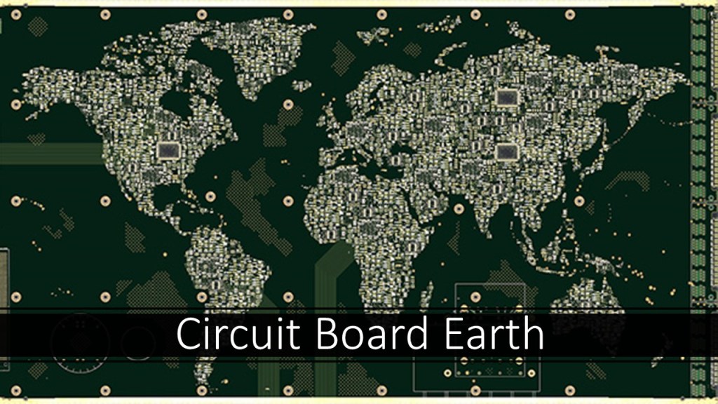
What is a circuit board?
A circuit board is a physical piece of technology that allows for the assembly of electrical circuits or data circuits on a horizontal layer of material.

I think the existence of the original civilization was destroyed by a deliberately-caused cataclysm within the last couple of hundred years, and most of this incredible infrastructure it constructed has been deliberately destroyed ever since then, into the present-day.
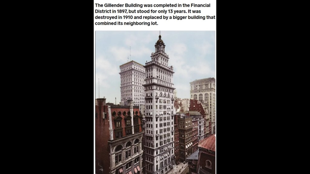
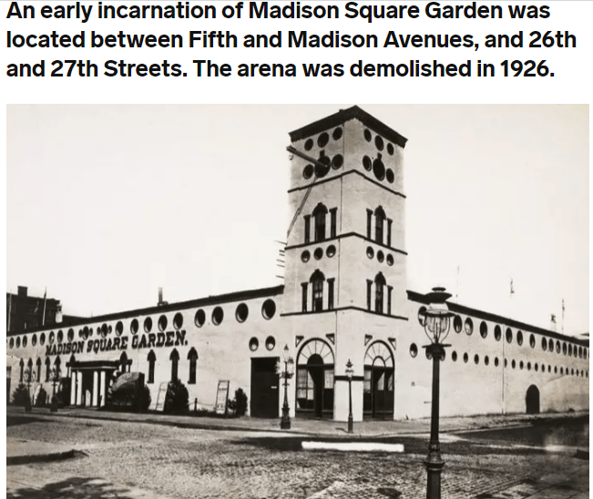
Here are a few of many examples of demolished monumental architecture in New York City alone:
The Gillender Building, said to have been completed in 1897, and destroyed in 1910, only thirteen-years later…
…a version of Madison Square Garden without a completion date that was demolished in 1926…
…the historic Hotel Astor in our historical narrative stood for only 63-years, between 1904 and 1967, before it was demolished and replaced by a high-rise…

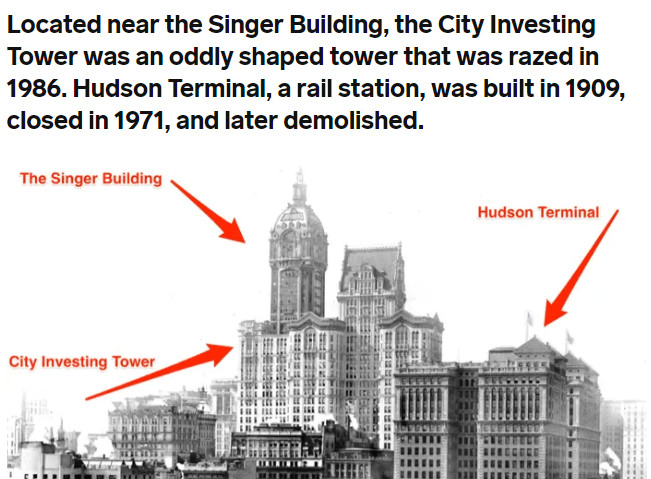
All three of these buildings in Manhattan were demolished, with the Singer Building, the headquarters of the Singer Manufacturing Company, said to have been completed in 1908, and demolished in 1968, along with the City Investing Tower the same year, and the Hudson Terminal Rail Station demolished at some point after closing in 1971.
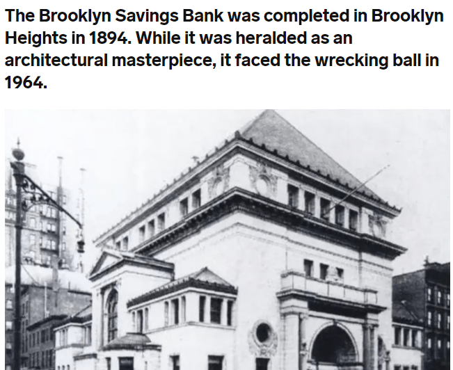
…as well as the Brooklyn Savings Bank, said to have been completed in 1894, and demolished in 1964.
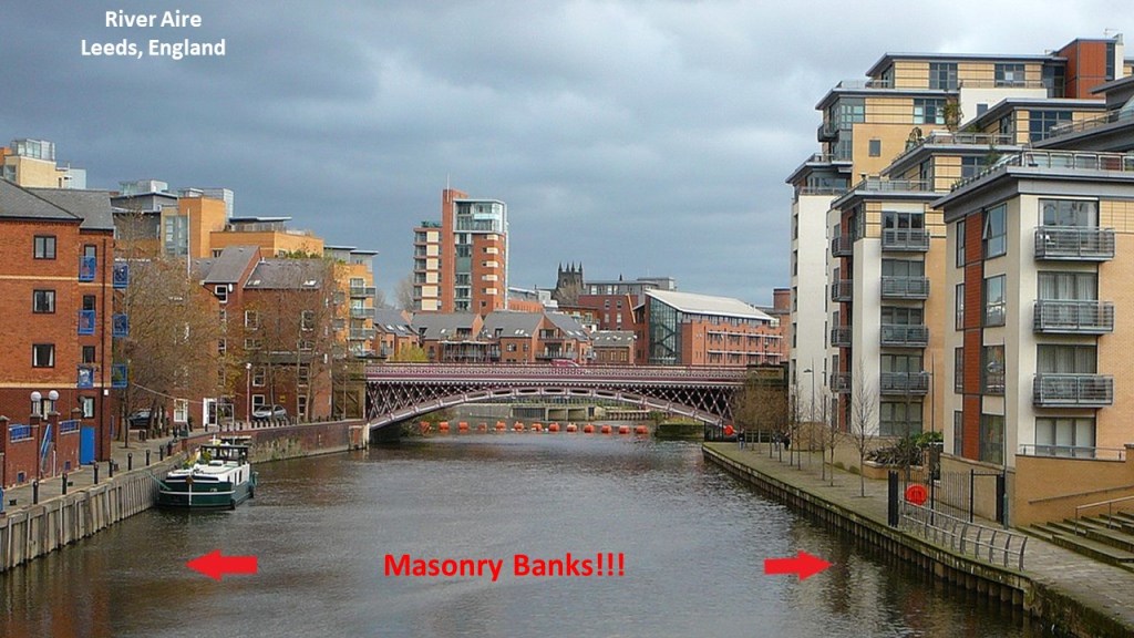
By the way, what do banks deal in?
Currency.
What is currency defined as?
A system of money in general use in a particular country.

What is a river current?
A river current is defined as the water moving in a river.
What is a river bank?
It is defined as the land at either edge of a river.
What is a river defined as?
A large natural stream of water flowing in a channel to the sea, a lake…or another such stream.
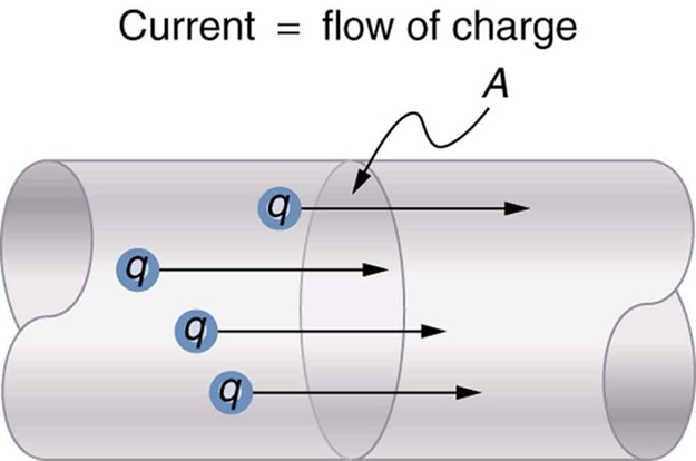
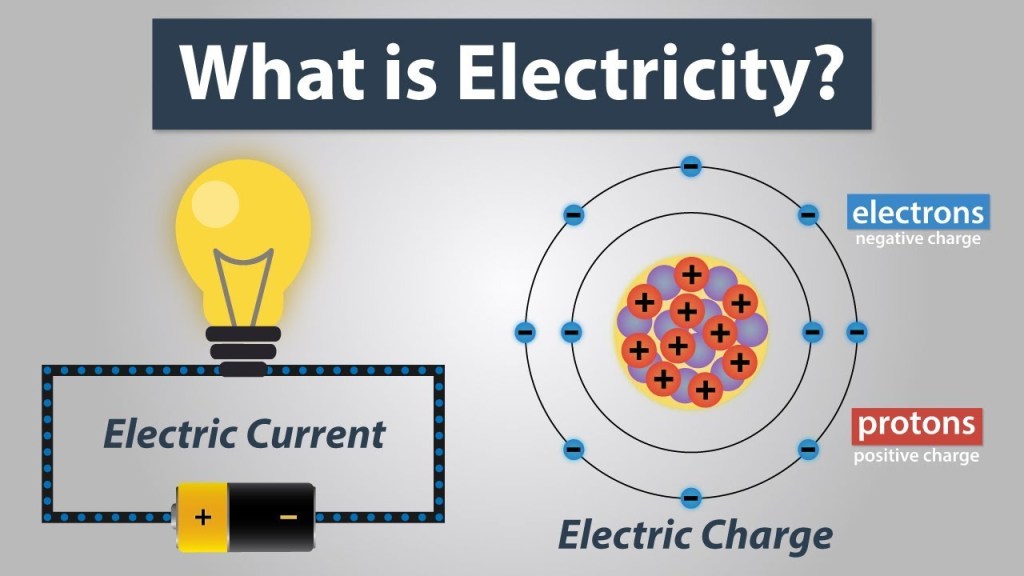
What is an electric current defined as?
A stream of charged particles, such as electrons or ions, moving through an electrical conductor or space.
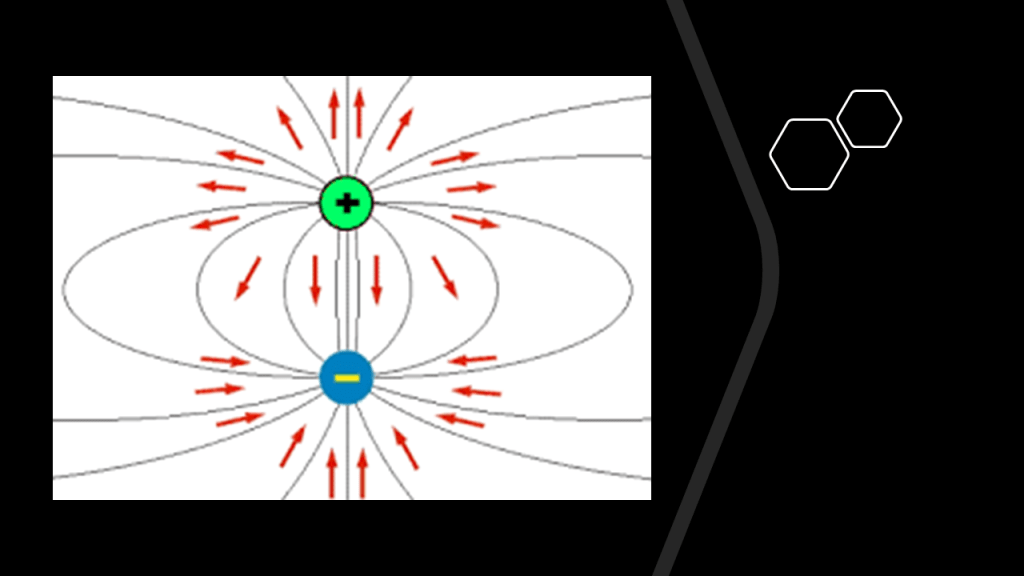
What does electrical “charge” mean?
It is the physical property of matter that causes it to experience a force, strength or energy as an attribute of physical action or movement, when placed in an electromagnetic field.
The word force also has meanings in English of coercion or compulsion, or making someone do something against their will.
In our everyday language, the definition of “charge” applies to a price for goods or services…

…and making a charge on a credit card allow us to have the charges for goods and services billed in the next credit card statement to the cardholder, giving the cardholder the option of making a full payment with no interest, or carrying a finance charge determined by interest rate established by the credit card company to borrow the money, sometimes fixed, and sometimes variable, with the penalty of being denied future credit based on one’s credit score and history.

Why all of these connections between terms used in the financial industry and terms used in electrical engineering?
Is there some kind of energy-harvesting going on between us and the financial system we have been operating under for the last 100- to 200-years?

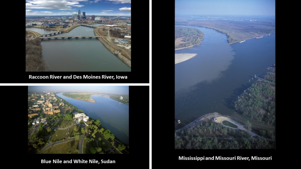
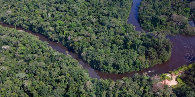
And are rivers actually natural?
I think they are man-made, considering that I consistently find the exact same snaky-S shaped of rivers all over the world, including but not limited to these rivers in Australia, Manitoba, Honduras, Louisiana, and Nova Scotia…
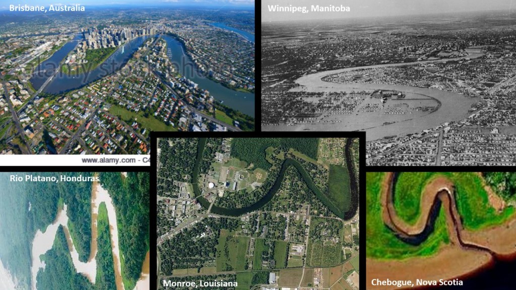
…and I find the same similarity going on with river confluences.
So to begin with making the connection of the physical infrastructure of the original civilization to a circuit board, I am going to start with identifying the infrastructure found worldwide known as star forts as batteries.
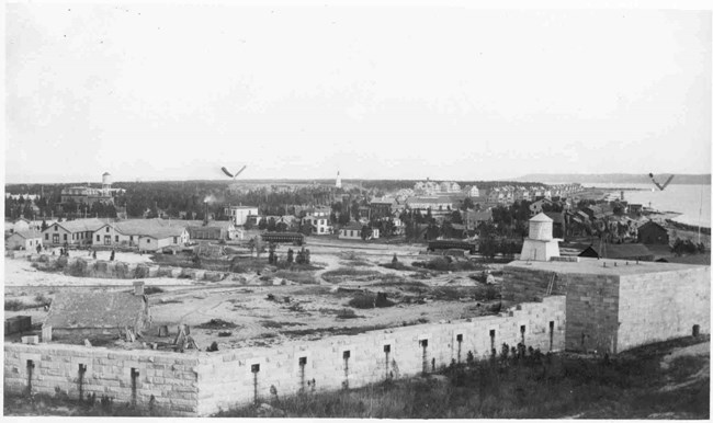
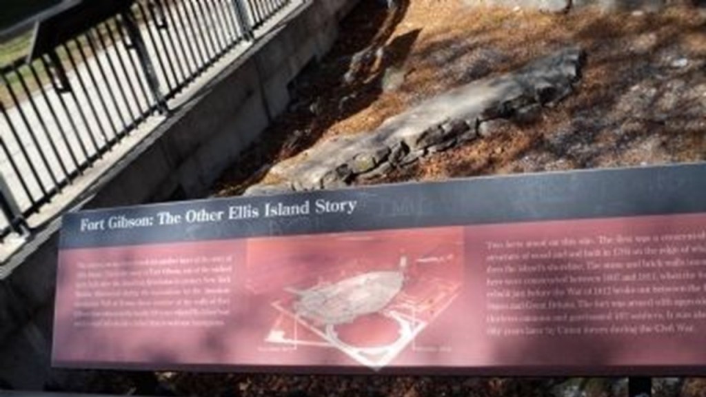
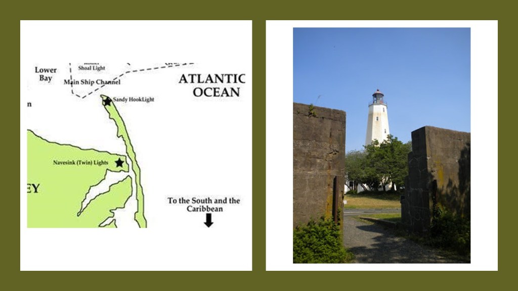
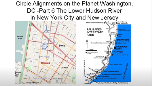
I can make a case that there were four pairs of star forts, with each pair situated along various points of the Lower and Upper New York Bays, even though the physical structure of what was called Fort Gibson on Ellis Island is long buried and gone.
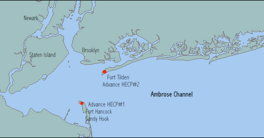
There was Fort Hancock on Sandy Hook at the Atlantic Ocean entrance to the Lower New York Bay was a star fort at one time…
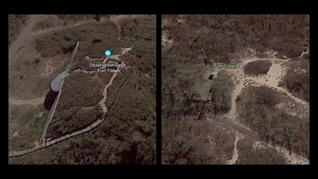
…and Fort Tilden on the Rockaway Peninsula in the Lower New York Bay, north of Fort Hancock and Sandy Hook.
Fort Wadsworth, also known as Battery Weed, located next to the Staten Island side of the Verrazzano-Narrows Bridge…
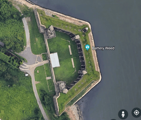
…located at The Narrows between the Lower and Upper New York Bays…
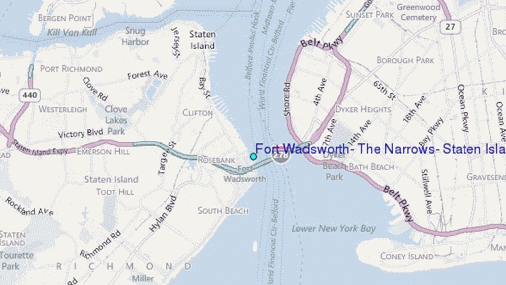
…and Fort Hamilton is at the base of the Brooklyn-side of the Verrazzano-Narrows Bridge.
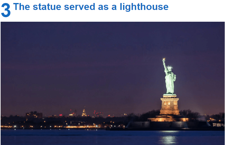
Fort Wood in the Upper New York Bay is underneath the Statue of Liberty…
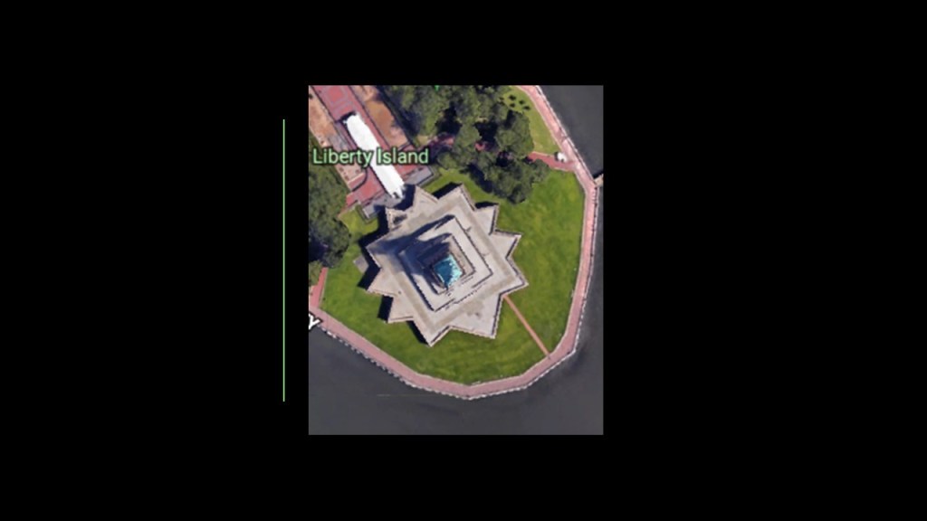
…across from Ellis Island…
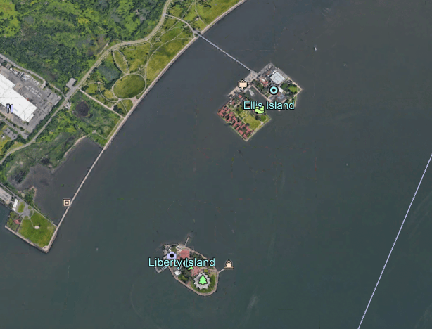
…upon which there used to be what was called Fort Gibson.
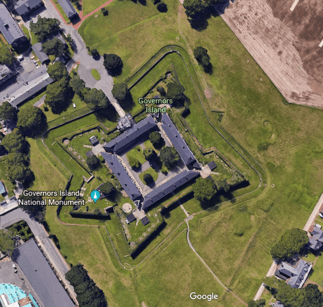
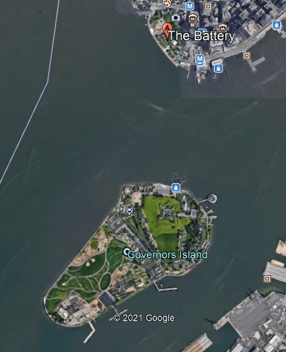
Fort Jay is on Governors Island at the convergence of the Hudson and East Rivers…
…across from Fort Amsterdam, which was located on…

…on what is now called The Battery.
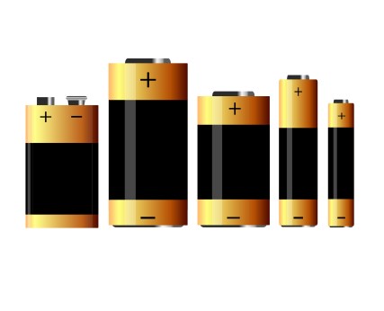
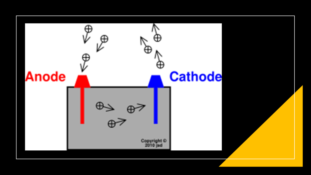
One definition of a battery is a device that produces electricity that may have several primary or secondary cells arranged in parallel or series, as well as a battery source of energy which provides a push, or a voltage, of energy to get the current flowing in a circuit.
The answer to the mystery of star forts lies in this definition – that these star forts, and other infrastructure I have shared with you that don’t feature the classic look of a star fort, functioned as circuitry and batteries for the purpose of producing electricity on the planetary grid system for the advanced civilization.
I consistently find star forts all over the Earth that are paired together in the same location, or found in clusters of more than two.
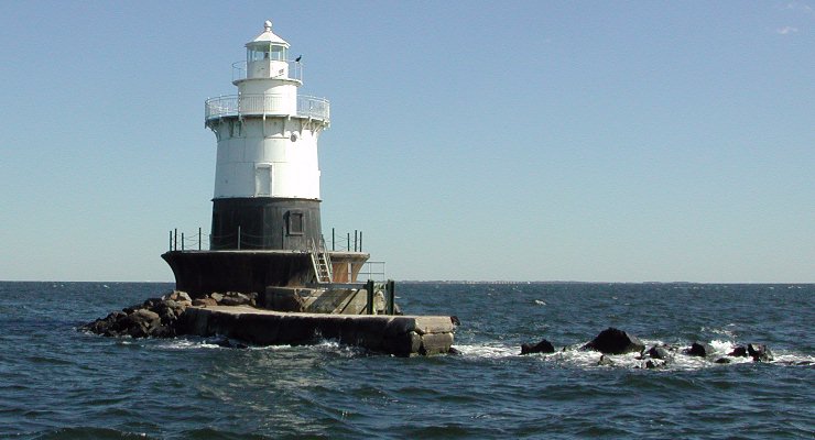
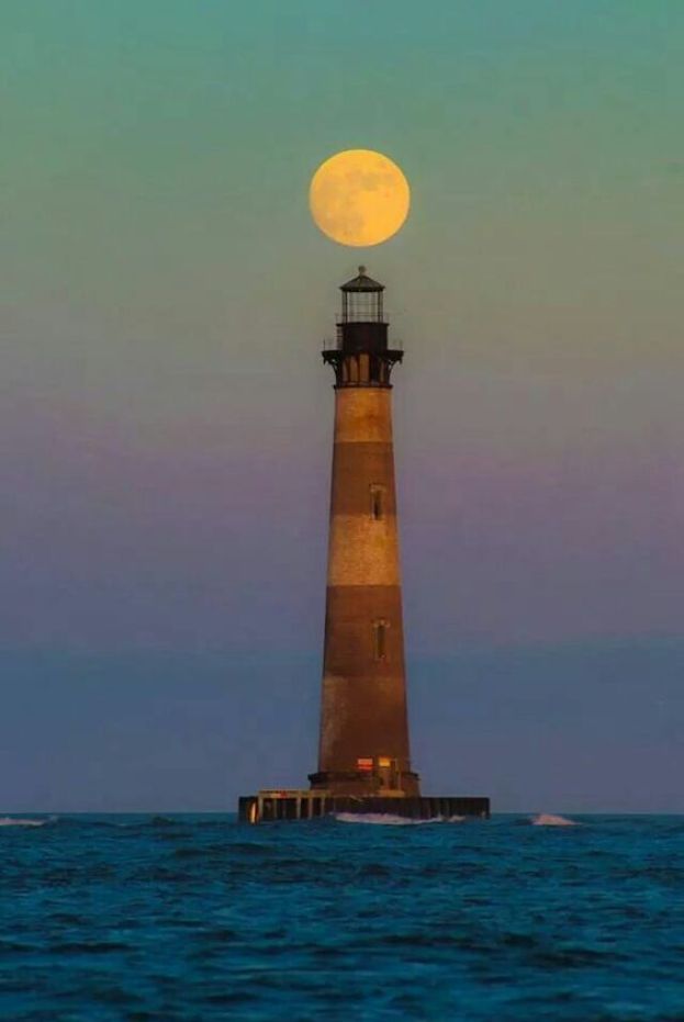
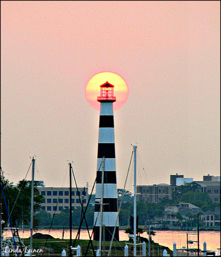
Lighthouses played some kind of function in concert with star forts.
For all we know, star forts have a connection to star energy and lighthouses are actual “Houses of Light,” because there is way more going on with the function of lighthouses than “a tower or other structure containing a beacon light to warn or guide ships at sea.”
Were they in actuality drawing down the cosmic energy to “charge” the star-fort batteries?
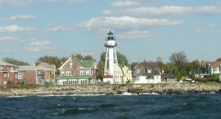
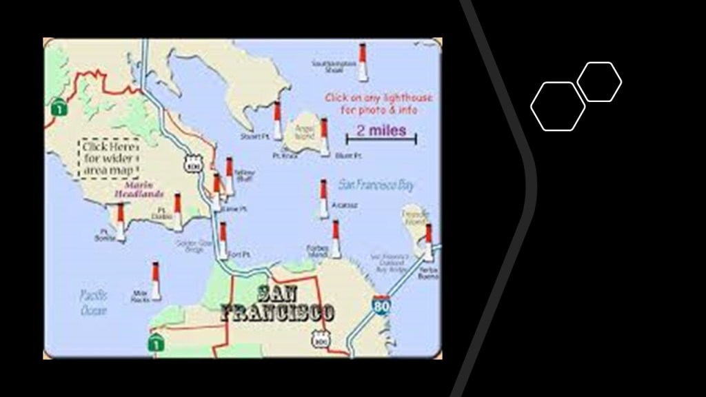
Here are examples of New York Bay Lighthouses.
The Sandy Hook Lighthouse, is located at the northern end of Sandy Hook at Fort Hancock, said to be the oldest working lighthouse in the United States, as we are told it was built in 1764.
Other Lighthouses of New York Bay include:
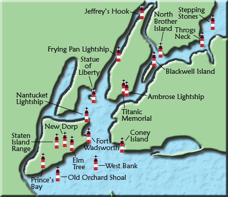
The Old Orchard Lighthouse is said to have been built in 1883, and is three-miles south of the center of Staten Island…
…the West Bank Lighthouse, which serves as the front-range light for the Ambrose Channel, which is used in navigation to indicate safe passage, or position fixing. It was said to have been built in 1901…

…the Staten Island Lighthouse is on Richmond Hill is the rear-range light for the Ambrose Channel, a 90-ft-high, or 27-meter, tower said to have been built in 1912, and is 141-feet, or 43-meters, above sea-level…

…the Coney Island Lighthouse on the western end of Coney Island, in Seagate, and situated east of the Ambrose Channel of New York Harbor. It was said to have been built in 1890…
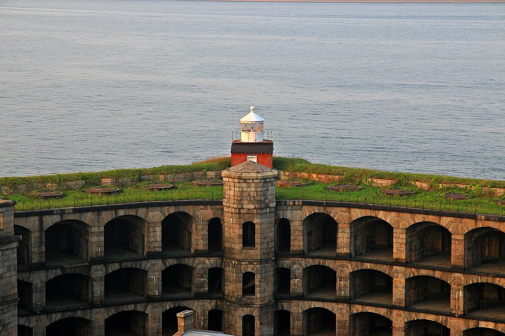
…the Fort Wadsworth Lighthouse, said to have been built on top of Battery Weed in 1903…
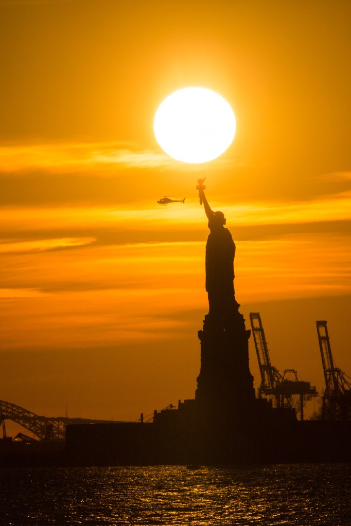
…and the Statue of Liberty on top of Fort Wood even served as an operational lighthouse starting on November 22nd of 1886, a month after it was officially opened, until March 1st of 1902, when we are told it was discontinued as a navigational aid.
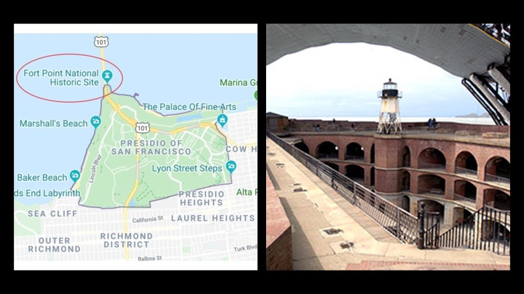
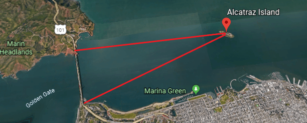
I found the same kind of star fort/lighthouse patterns occurring on the other side of the continent in San Francisco Bay.
There is a star fort and lighthouse on the south-end of the Golden Gate Bridge…
…with the Battery Boutelle nearby on the Presidio Grounds beside the bridge.
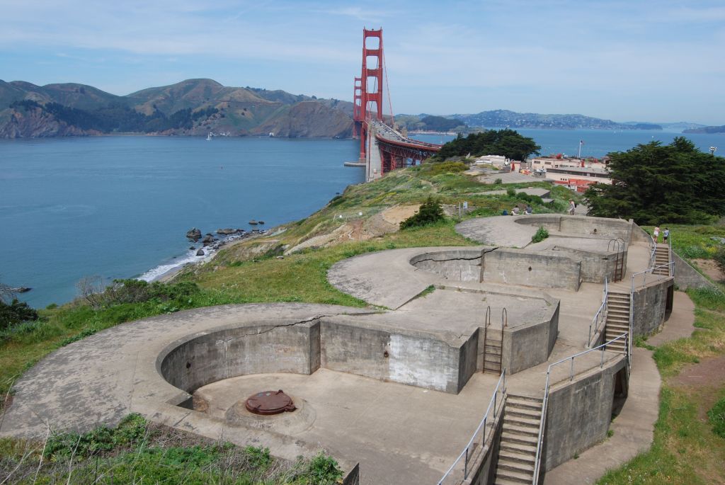
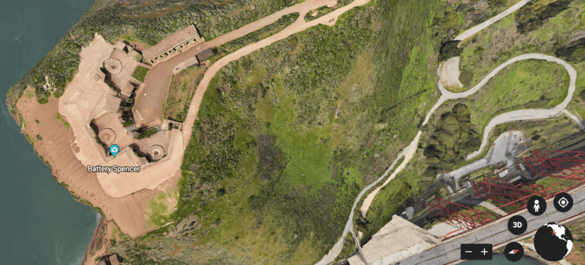
On the other side of the Golden Gate Bridge, we find Battery Spencer on the other side of the bay right next to the bridge…
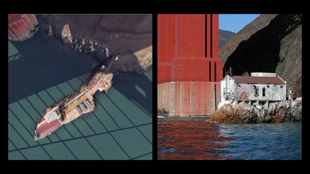
…and underneath the base of the Golden Gate Bridge, is the Lime Point Lighthouse, said to have been built in 1883 and automated since 1961.
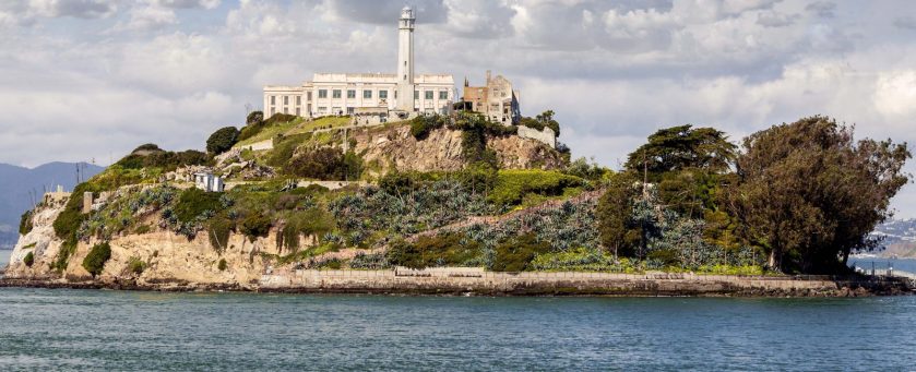
Alcatraz Island, 1.25-miles, or 2.01-kilometers off-shore from San Francisco in San Francisco Bay. It is best known as an infamous federal penintentiary for troublesome prisoners.
There is a lighthouse on Alcatraz Island.
To put the lighthouse into the context of the historical narrative we have been given, the island of Alcatraz was said to have been given by the Mexican Governor Pio Pico to Julian Workman in 1846 to build a lighthouse on it.
Workman was a member of the Workman and Temple families prominent in the history of the Los Angeles area.
Another thing to point out is the location of this lighthouse and Alcatraz with respect to the Golden Gate bridge, and the two lighthouses on either end of the bridge.
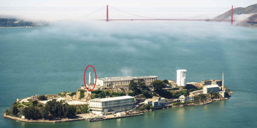
There appears to be a triangulated relationship between the lighthouse on Alcatraz Island, the Fort Point Light on the Presidio side of the Golden Gate Bridge, and the Lime Point Light on the other side of the bridge.
More on this in a moment.
There is a whole series of lighthouses running throughout the San Francisco Bay.
I also consistently find lighthouses with astronomical alignments, like these examples:

On the Isle of Alderney, one of the Channel Islands off the coast of France, there’s a triangulated relationship between the Alderney Lighthouse, Fort Quesnard, and the ruins of Fort Les Hommeaux Florains.

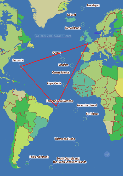
There is also a triangulated relationship between the islands of Bermuda and Fernando de Noronha in the Atlantic Ocean, and the Channel Islands in the English Channel, three places with a high-concentration of star forts for their small sizes.
There are other places/regions with a high-concentration of them, like they are some kind of energy nodal points on the Earth’s grid system.
I just want to demonstrate that there are clear relationships existing between all of this infrastructure.
The Isle of Wight, just off the coast of southern England in the English channel, has a number of star forts and lighthouses.
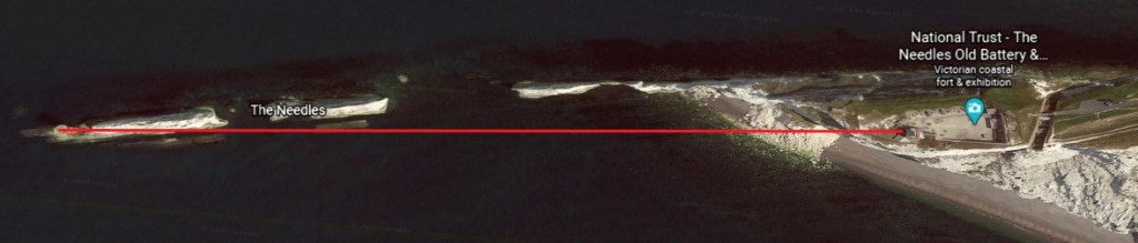
One of them, the Needles Lighthouse, stands 109-feet, or 33-meters, tall on the outermost of the Chalk Pillars, was said to have been built out of granite blocks in 1859 for Trinity House, the official authority for lighthouses England, Wales, the Channel Islands, and Gibraltar.
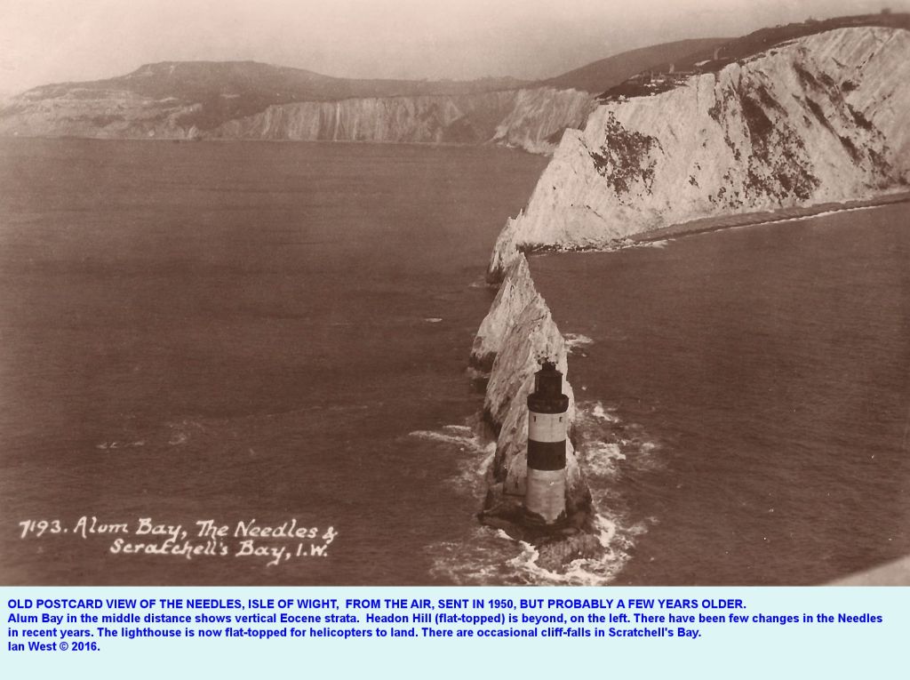
I find it interesting that the description in this photo says that the lighthouse “is now flat-topped for helicopters to land.”
It’s an active lighthouse, and apparently needed under-pinning work in 2010 to keep it from falling into the sea.
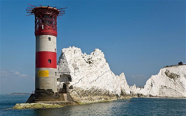
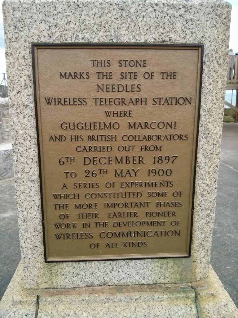
What is described as the world’s first long-distance radio signal was sent by Marconi from Alum Bay beside the Needles in the year 1897.
I wonder what it was about this location that influenced his decision to do his work on wireless communication here.
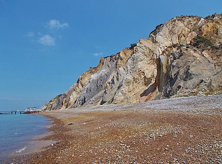
I am sure one of the things is that the sand of the bay here includes extremely pure white silica, an important component for enhancing radio frequency transmission.
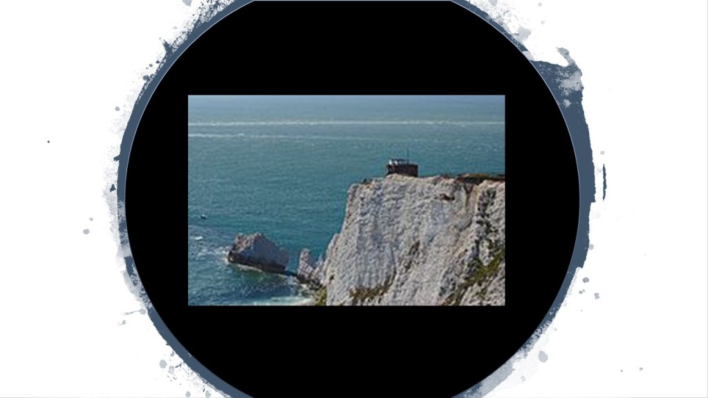
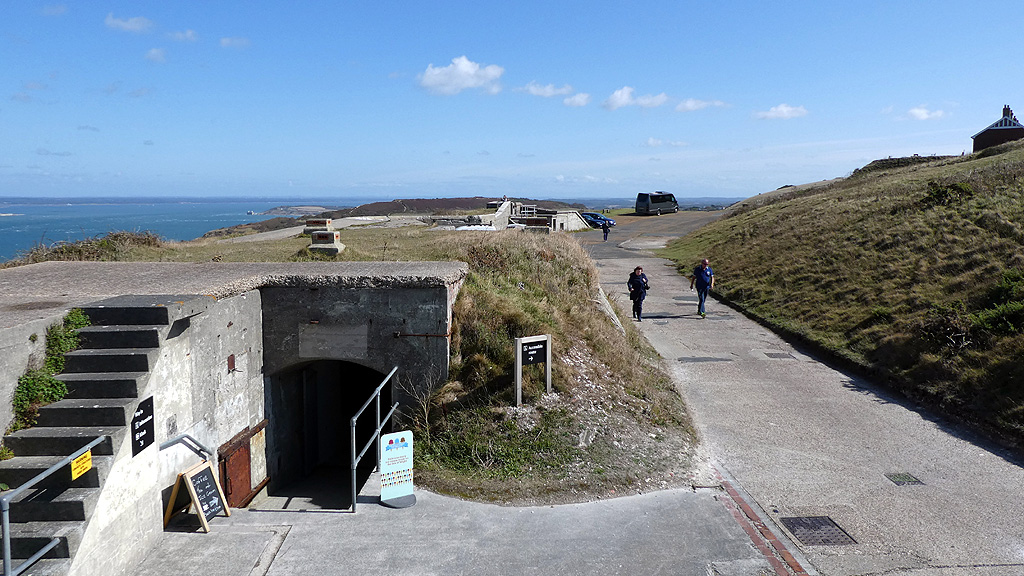
The Old Needles Battery is situated on a chalk cliff located right above the chalk pillars.
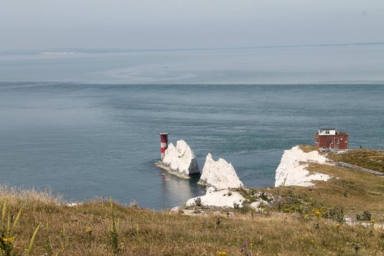
It was said to have been built between 1861 and 1863 as a coastal defense against French Invasion.
The Old Needles Battery has a tunnel leading to…
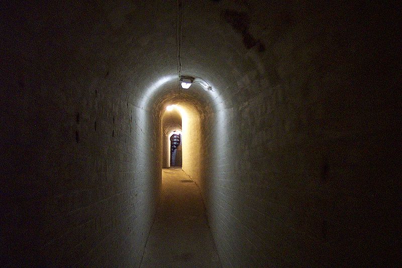
…its searchlight emplacement…
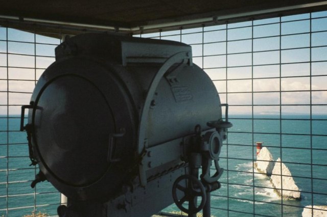
…in linear alignment with the Needles Lighthouse.
The Needles New Battery was said to have been completed in 1895, higher up on the same cliff, and said to have been constructed because of concerns about subsidence problems with the old battery and concussion from firing the batteries guns causing the cliffs to crumble.
The next components of Circuit Board Earth that I am going to look at are…well…circuits.
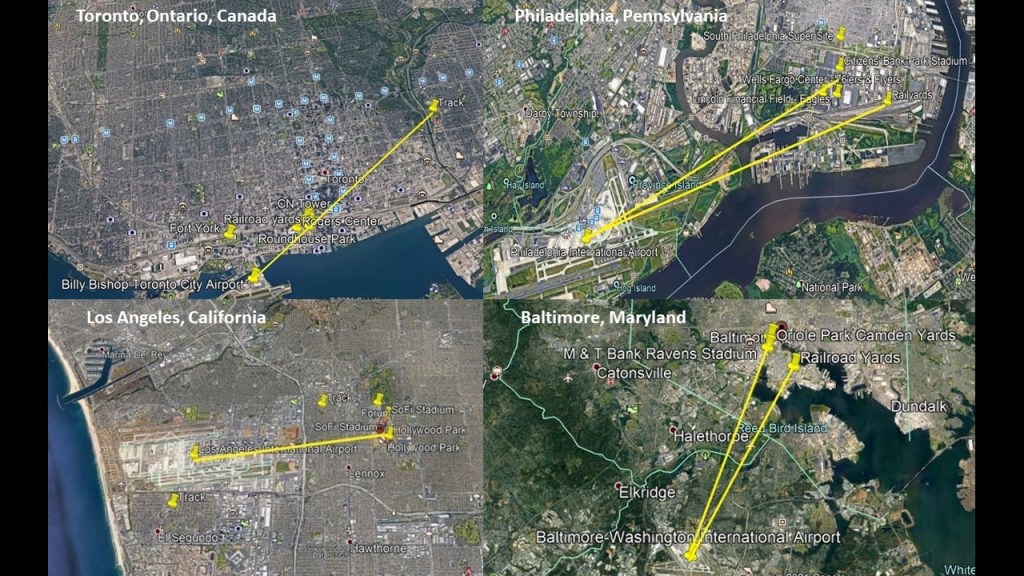
In one of the series that I did on researching places viewers made in comments, I discovered airports having racing tracks in angular relationships short distances away.
I first noticed this when I was doing research on the Shepherd’s Bush District of West London based on a commenter’s suggestion.
In the process of doing that, I realized I had seen the same angular relationship between London’s Heathrow Airport, and Shepherd’s Bush on the top left, where there had been a huge track at one time in White City, that had been used for Greyhound racing; and in my own research of the Tampa, Florida, neighborhood of Sulphur Springs last summer, when I had noticed that the Tampa International Airport, and the Sulphur Springs neighborhood in Tampa, Florida, where there was a greyhound racing track, had the same angular relationship.
After I made that initial connection, commenters left other examples of the same kind of relationship between airports and racing tracks, past and present, including, but not limited to, places like Montreal, Quebec, Canada, on the top right; Philadelphia, Pennsylvania on the middle left; Toronto, Ontario, Canada, in the middle ; Los Angeles, California on the middle right; and Sydney, Australia, on the bottom.

In addition to airports and racetracks, I am also finding things like railroad yards, professional sports complexes, star forts and even amusement parks with the similar characteristics and relationships to each other that I am finding in different cities around the world.
In these Google Earth screenshots, all the lines drawn go through or to professional sports complexes, and railyards in Toronto, Philadelphia, and Baltimore.
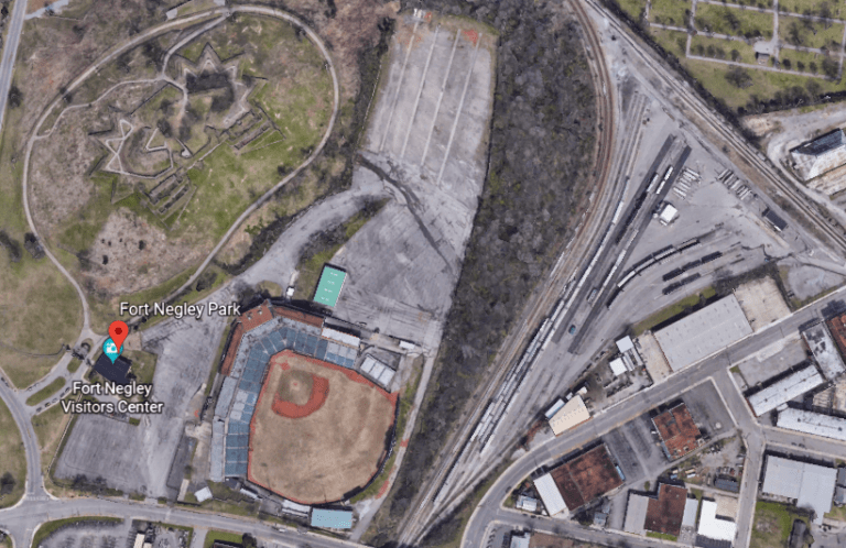
I have long-wondered about a connection between athletic fields to the Earth’s grid system since finding ball-fields sandwiched between a star fort in called Fort Negley and the railroad yards in Nashville…
…and the connection of railroads to star forts when I found the former location of the Fort of Pensacola on the bottom right..
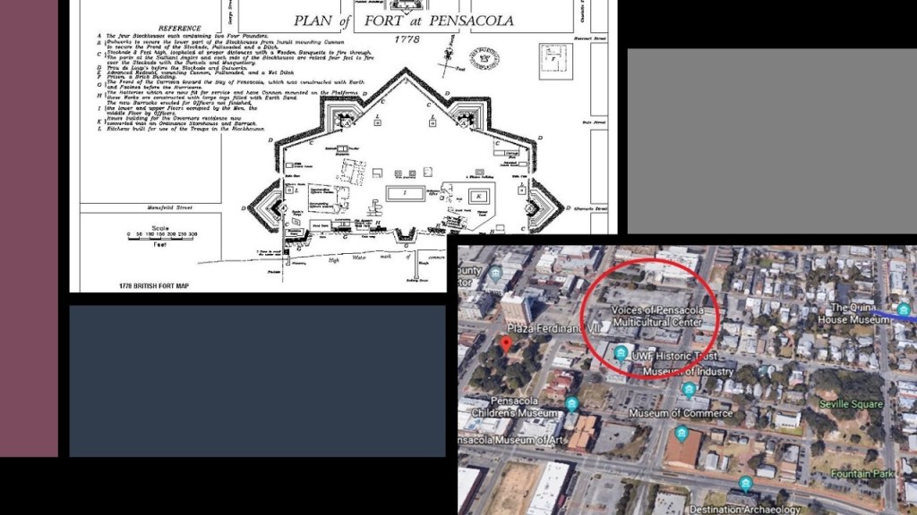
…and this map shows its previous location with railyards just below the former location of the Fort of Pensacola, the lay-out of which immediately reminded me of circuit board diagrams.
More upcoming on rail-lines of all kinds.
I think ellipses being used as racing-tracks were once omponents of the circuitry of the Earth’s electro-magnetic grid system.
The sport of racing uses the word “circuit” in the following ways:
The course over which races are won…
…the number of times the racers go around the track…

…an established itinerary of racing events involving public performance…

…and in bicyle racing, a circuit race is a mass-start road-cycle race that consists of several laps of a closed-circuit, where the length of the lap is slightly longer each time.

Electrical Circuit definitions Include:
A closed path in which electrons from a voltage or current source flow, and includes devices that give energy to the charged particles the current is comprised of, such as batteries and generators…
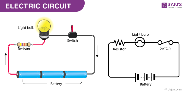
…devices that use current, like lamps, electric motors, and computers…

…and the connecting wires or transmission lines.
An electronic circuit is a complete course of conductors through which current can travel, and provide a path for current to flow.

The Indianapolis Motor Speedway is the largest sports’ venue in the world, and said to have been constructed in 1909.
Check this out: Vatican City, the Wimbledon Campus, the Roman Colosseum, the Rose Bowl, Yankee Stadium, and the Kentucky Derby all fit inside the automobile racing CIRCUIT.
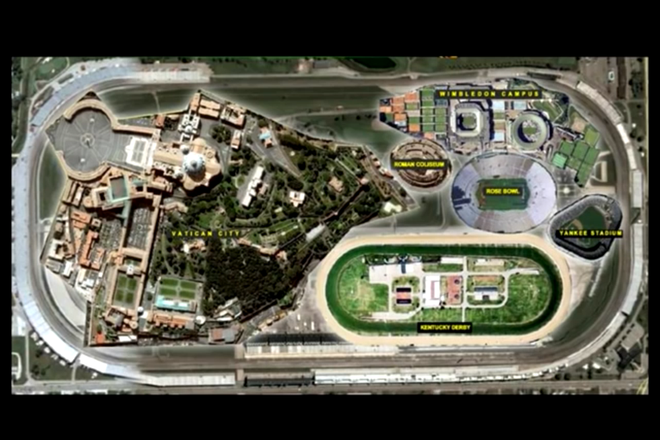
Wouldn’t it stand to reason that those behind the reset when setting up the New World would take advantage of the super science of the different types of circuits in the Earth’s grid system in order to harness their inherent power to enhance performance at sporting events, to make lots of money at highly-charged, prestigious gaming and betting venues?

In regards to similar configurations found in different cities, in Cincinnati, Ohio, the city’s professional sports stadiums are downtown next to the Ohio River, and interestingly, they are situated on the river exactly like they are in Pittsburgh, Pennsylvania.
The Paul Brown Stadium, home of the NFL Bengals, is on the left riverfront; the Great American Ball Park, home of the MLB Reds on the right riverfront.
There is a park directly in front of the Paul Brown Stadium, known as the Cincinnati Riverfront Park, just like in Pittsburgh, where the Roberto Clemente Park in front of the Heinz Field Stadium of the Pittsburgh Steelers, which is located next to the PNC Park home of the Pittsburgh Pirates; and a bridge located between both sporting venues.
Is the identical configuration only a coincidence, or part of a much larger configuration?

What else is similar between Pittsburgh and Cincinnati?
There’s the geographic landmark and residential neighborhood of Mt. Adams, a flat-topped-looking earthwork that at one time had an incline Railway…
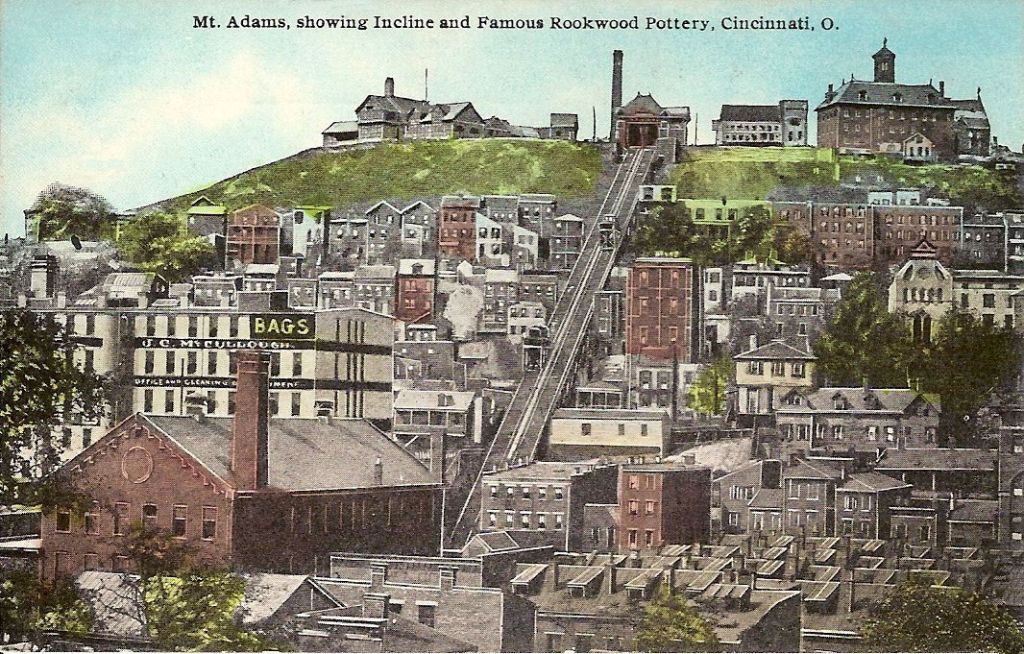
…just like Pittsburgh, which has two remaining incline railways, out of what was originally seventeen in Pittsburgh, on the flat-topped Mount Washington, named the Duquesne and Monongahela Inclines.

The Mount Adams Incline operated from 1872 until 1948. Long since demolished, it was the longest running incline of Cincinnati’s historic five incline railways.

…and the Immaculata church and Holy Cross Monastery, said to have been built in 1895 and 1901 respectively…
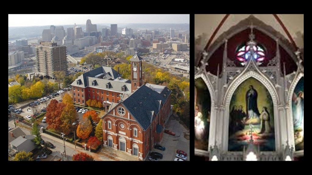
…are close to the edge of Mt. Adams overlooking the river, like St. Mary of the Mount on top of Mount Washington back in Pittsburgh.

For examples of similarities in other places, this is a Google Earth screenshot showing the angular relationships between the Saratoga Race Course, and just a portion of the large number of airparks, airfields, and airstrips in this part of New York State.
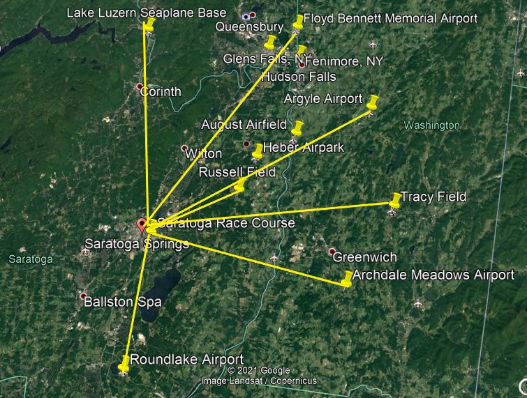
The Saratoga Race Course is a thoroughbred horse racing track in Saratoga Springs, New York. It is one of the oldest sporting venues in the United States, having opened on August 3rd of 1863 (which would have been in the middle of the American Civil War).
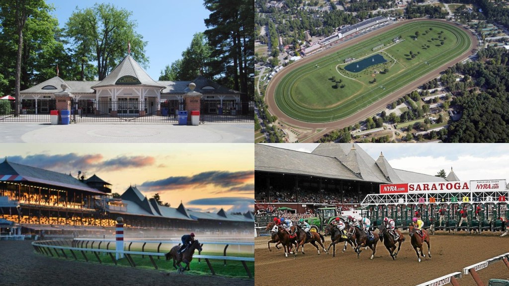
The Saratoga Race Course has been in use pretty much continuously since it first opened.
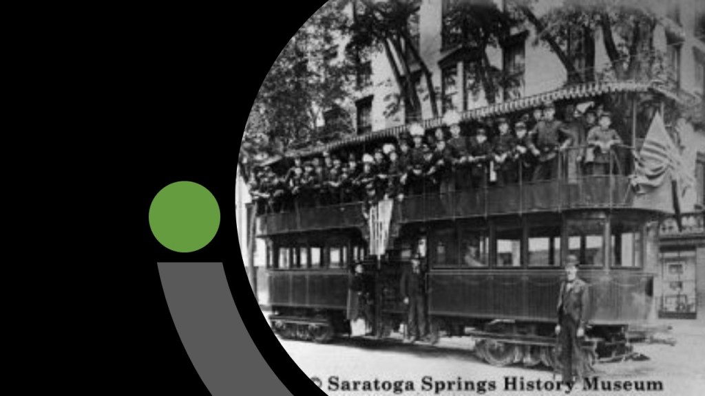
The name of Saratoga Springs reflects mineral springs that are in the area, and the High Rock Spring in this location is believed to have medicinal properties, making it a popular resort destination for over 200 years.

Saratoga Springs has a history of railroad service…and trolley cars until 1938.
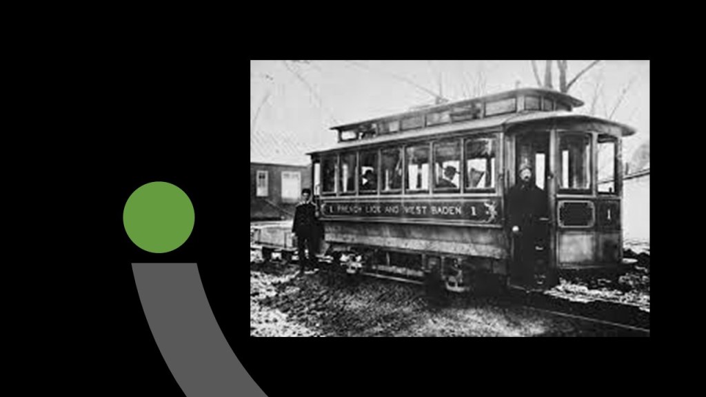
I have also looked into West Baden Springs in French Lick, Indiana.
The hotel for the resort was said to have been built in 1901 in the Moorish architectural style, and from 1902 to 1913, was said to have the largest dome in the World.

It had a trolley system…
…and the largest bicycle track in the country, a covered double decker.
The double-decker bicycle track, however, was said to have been nearly demolished by a windstorm that blew through the area on July 25th of 1925…

…and when the owner received an insurance check for $100,000, he tore the rest of the structure down, and it was gone by the fall of 1925.

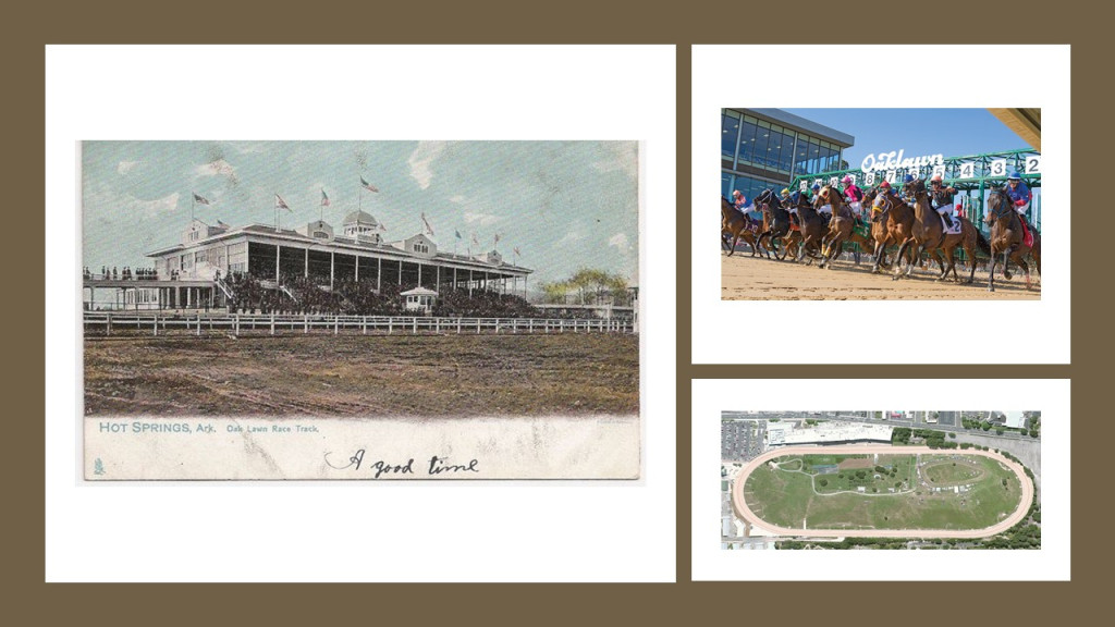
Similar relationships exist in Hot Springs, Arkansas, where the Oaklawn Racing Casino Resort, a thoroughbred horse-racing track that first opened in February of 1905, is near, and in an angular relationship to, the Memorial Field Airport.

Oaklawn was ranked 5th in 2017 by the Horseplayers Association of North America.
Hot Springs also had electric rail cars at some point in time…

…and the Hot Springs Street Railroad ran around Hot Springs to and from the Oaklawn Race Track.

So there definitely seems to be some kind of connection to different kinds of mineral springs with regards to all of this infrastructure.
Definitions of the word spring include:
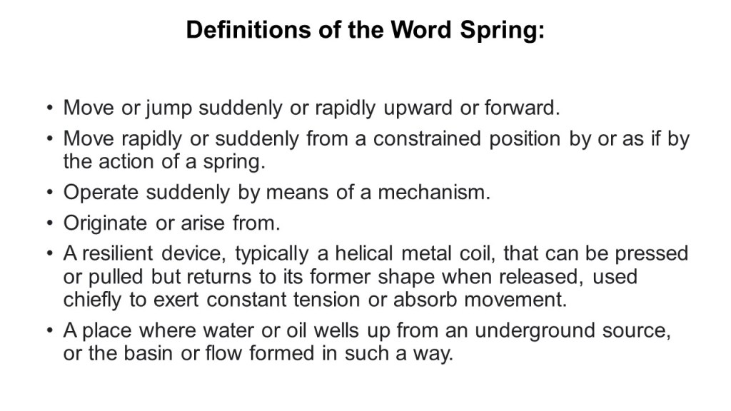
I don’t know exactly what the function of mineral springs would be on the circuit board for this free-energy-generating system, but it could very well be contained within one or all of the non-water definitions.
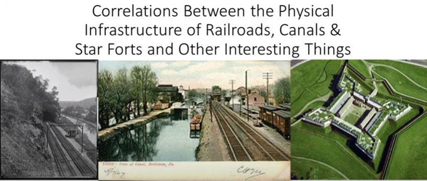
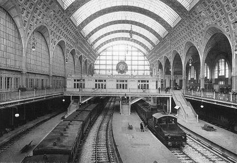
When I was doing research on the “Correlations between the Physical Infrastructure of Railroads, Canals & Star Forts and Other Interesting Things” almost two years ago…
…I ended with this photo, which had the caption of “Electric trains operating in the Gare d’Orsay, circa 1900.”
“Electric” trains. Hmmm.
The Gare d’Orsay railroad “terminal” was said to have opened in Paris in 1900.
This finding led me to look up the definition of the word terminal for the first time.
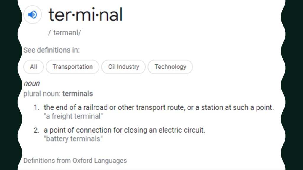
There are two definitions of terminal.
One is: “The end of a railroad or other transport route, or a station at such a point.”
The other is: “A point of connection for closing an electric circuit.”
There’s that electrical engineering terminology again.
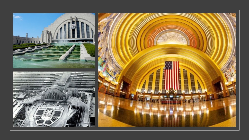
And old railroad stations around the world are architectural creations of great beauty and grandeur.
These magnificent old creations are still in use:
This is the Cincinnati Union Terminal, which has the largest half dome in the western hemisphere…
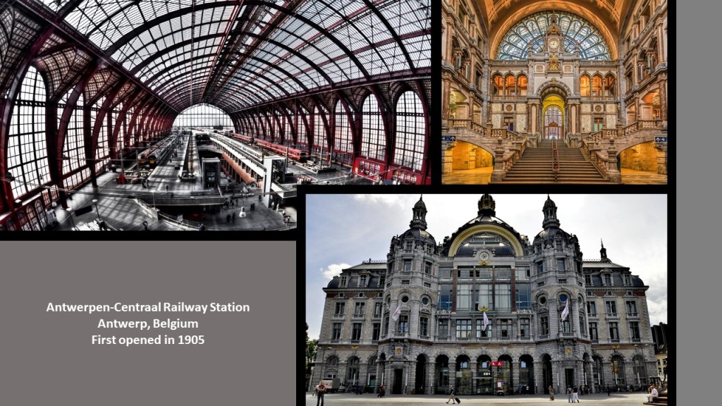
…the Antwerp Central Railway Station in Belgium, which first opened in 1905…
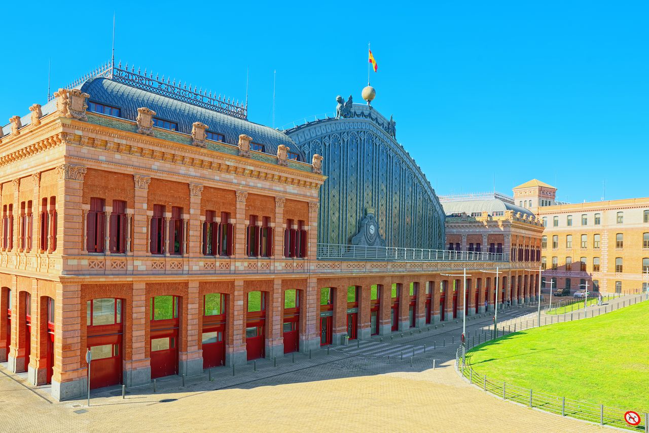
…the Madrid Station in Spain…
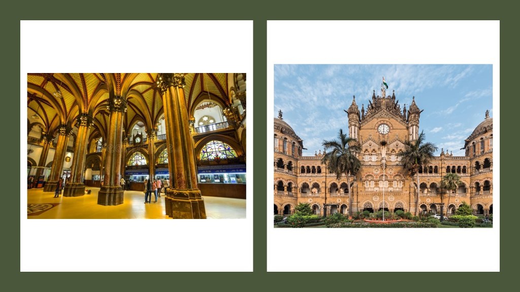
…and what used to be called the Victoria Terminus Station, and is now called the Chhatrapati Shivaji Terminus in Mumbai, India.
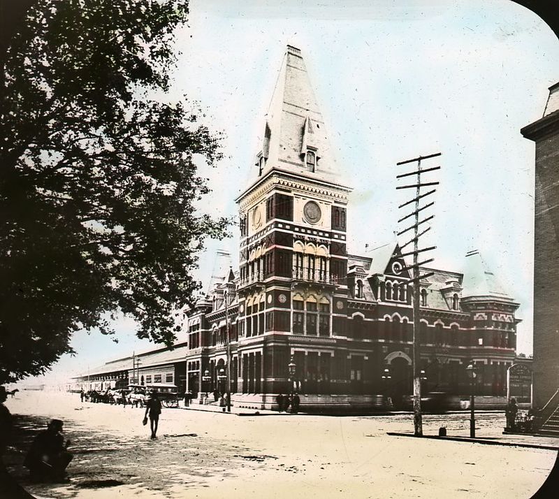
These magnificent train terminals are long gone:
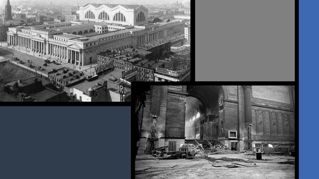
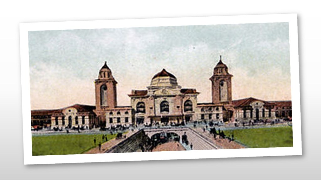
Pennsylvania Station in Manhattan, said to have been built between 1905 and 1910…and demolished in 1963.
The Atlanta Terminal Station in Atlanta, Georgia, which opened in 1905, and was demolished in 1972…
…and the Birmingham Terminal Station in Birmingham, Alabama, said to have been completed in 1909, and demolished in 1969.
The Baltimore and Potomac Railroad Station on Pennsylvania Avenue in Washington, DC, was said to have been built in 1873 and demolished in 1907.
It was the location of President James Garfield’s assassination in 1881.
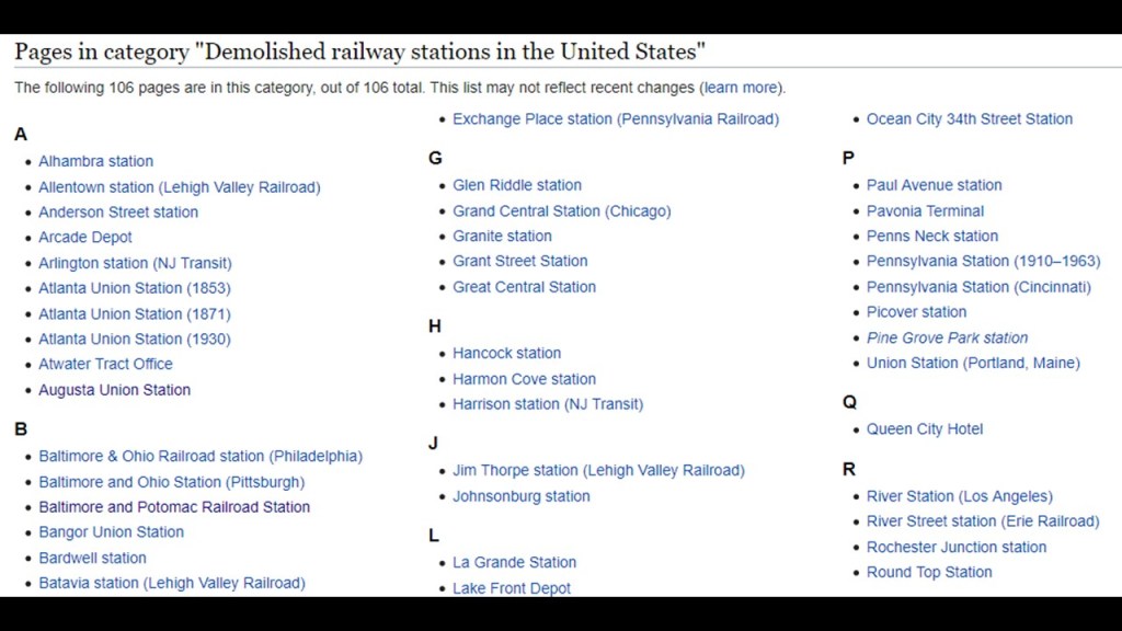
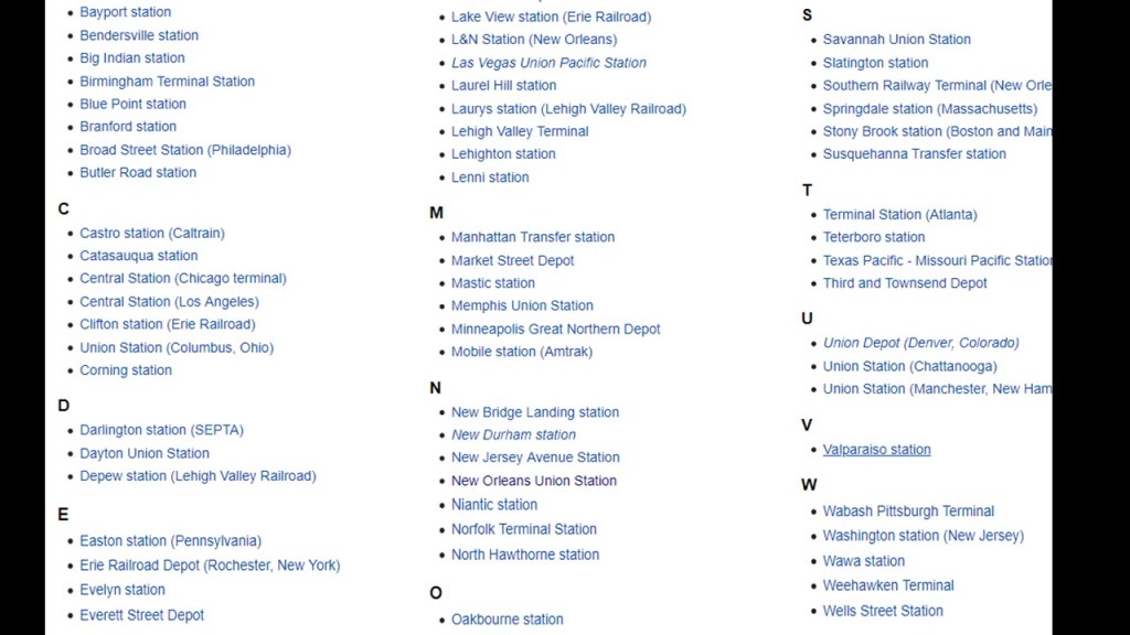
Here is a list of demolished railway stations in the United States alone:
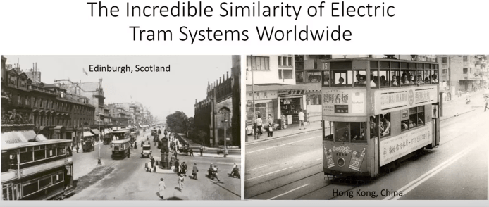
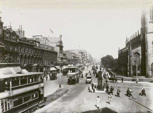
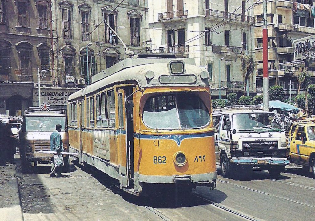
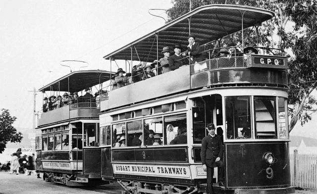
Then there is the subject of electric streetcar systems, also known as “trams” and “trolleys”….and which look the same all over the world…
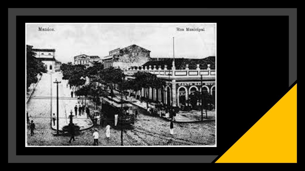
…and showed up historically in the most unlikely places, like Manaus, in the heart of the Amazon Rainforest in Brazil.
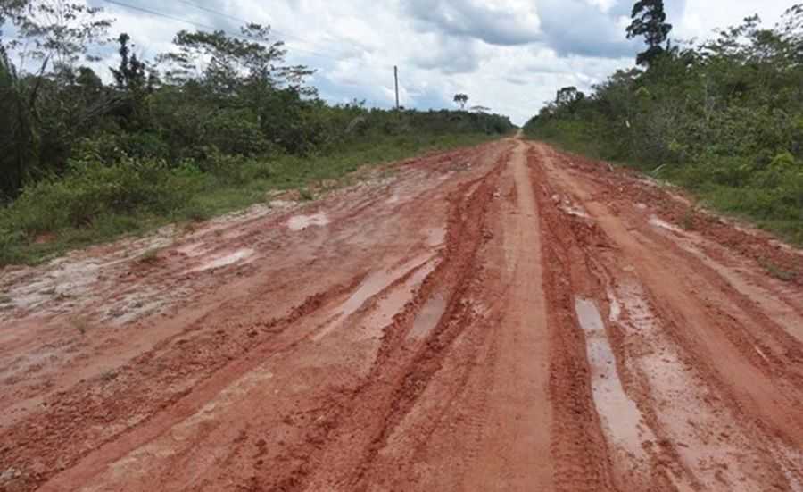
No road connection to Manaus existed until 1973, with the completion of the BR-319, connecting Manaus to Porto Velho, Brazil. It is 540 miles long, or 870 kilometers, going through the rainforest, and is impassable when it rains. It is known as Brazil’s worst highway.
There is no such tram system operating in Manaus today.
The history we have been taught does not provide a reasonable explanation for what was really going on here. This is a photo of undeveloped Amazon rainforest near Manaus. How are they supposed to have built all of this in the mid-to-late 1800’s under these conditions?
The same streetcar systems were found from Edinburgh Scotland, which as Edinburgh Corporation Tramways were said to have operated between 1871 and 1956…
…to Hong Kong, where they began operating in 1904…

…to Alexandria in Egypt, where streetcars began operating in 1863…
…to Hobart in Tasmania, where streetcars were in operation from 1893 to 1960.
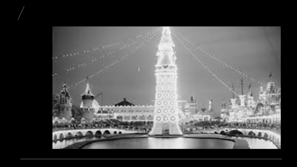
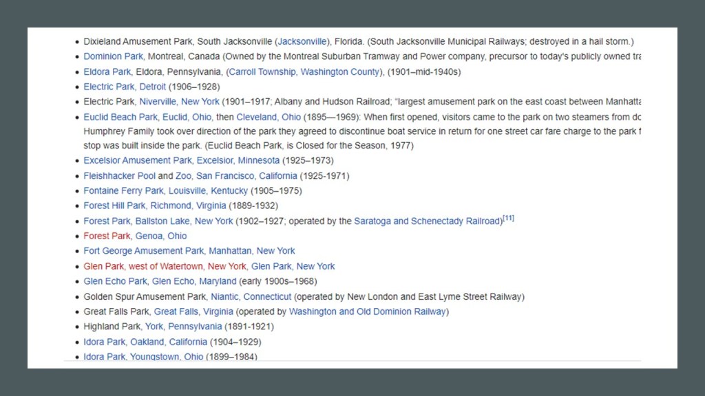
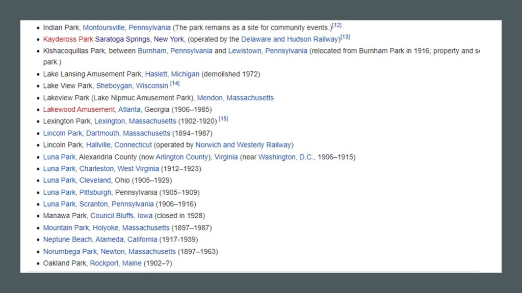
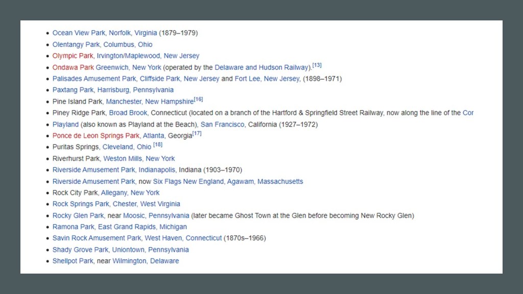
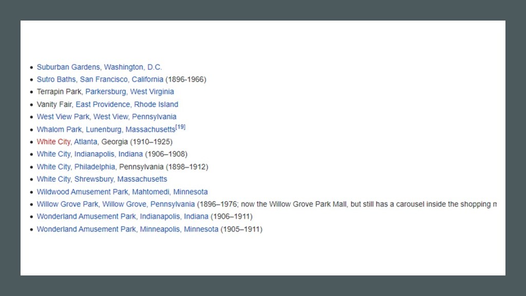
Then there is the noteworthy subject of trolley parks.
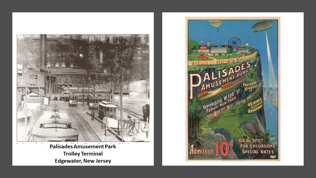
Palisades Park in Fort Lee, New Jersey,was the first trolley park I ever stumbled across when I was doing research here in May of 2019 following cities and places in a circular alignment from Washington, DC…
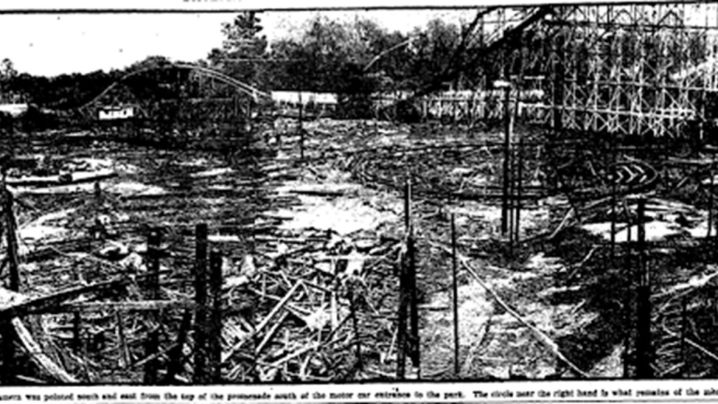
…and where I first learned that trolley parks were said to have started out in the United States in the 19th-century as picnic and recreation areas at the ends of street-car lines, and that by the 1920s, these trolley/amusement parks started to suffer a steep decline for a variety of reasons, including destruction by fire more often than not.
Palisades Park was in operation from 1898 until its closure in 1971, at which time it was demolished, and four luxury, high-rise apartments were built in its place.
Electric Park in Kansas City, Missouri, was said to have provided the inspiration for a young Walt Disney for his theme parks.
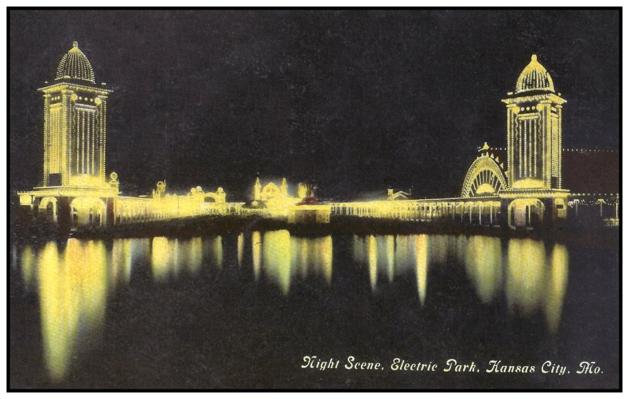
Electric Park was said to have been built in 1907 and was closed in 1925…
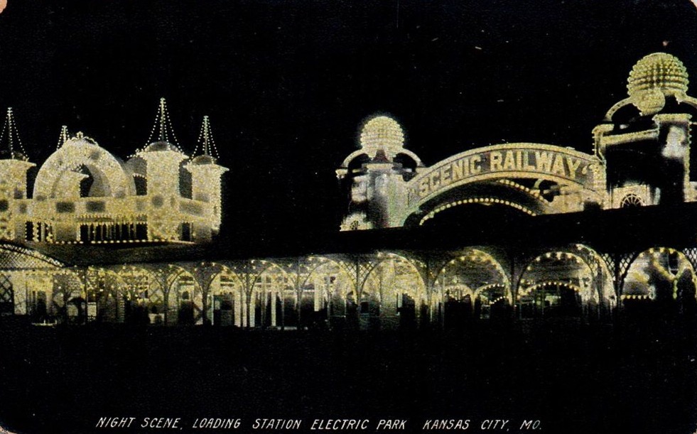
…at which time most of it burned to the ground.
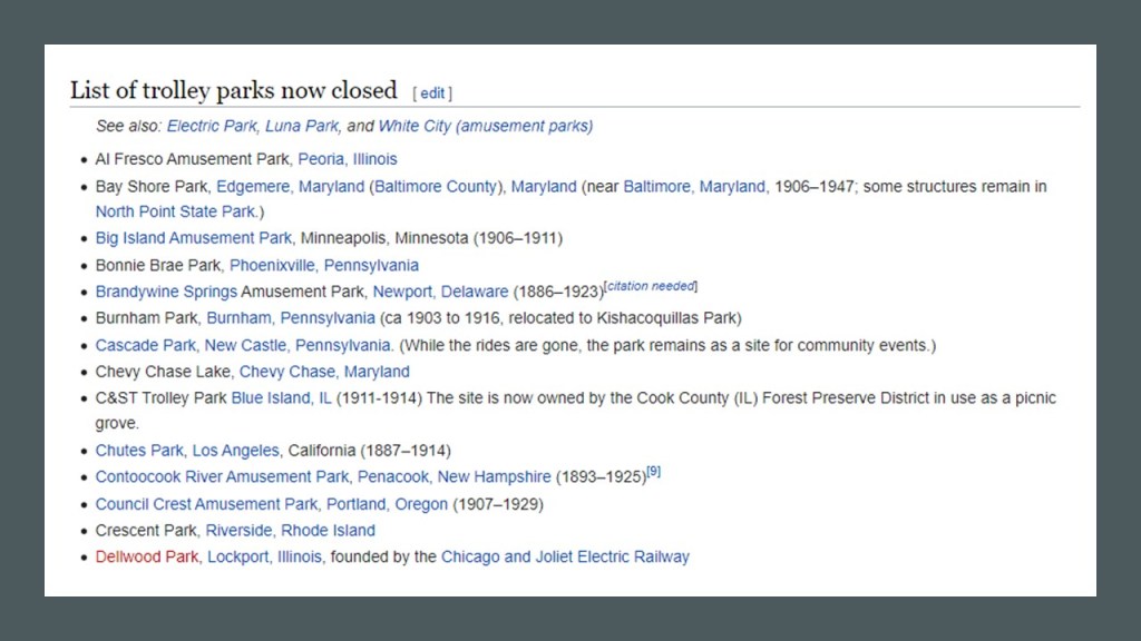
Trolley Parks in the United States were not an isolated occurrence.
While some of the original trolley parks remain in operation…
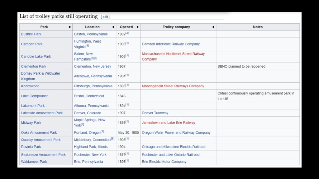
…that list is short compared to the ones that are no longer in existence.
Since Trolley amusement parks were typically located at the end of streetcar lines, I think they provided some kind of enhanced energy-generation going in the earth’s free-energy-generating system, and provided the local communities of the original advanced civilization with an opportunity to have fun at the same time.
Then, there were Interurbans, a type of electric railway with self-propelled rail-cars running between cities or towns in North America and Europe.
They were prevalent in North America starting in 1900, and by 1915, interurban railways in the United States were operating along, 15,500-miles, or 24,900-kilometers of track.
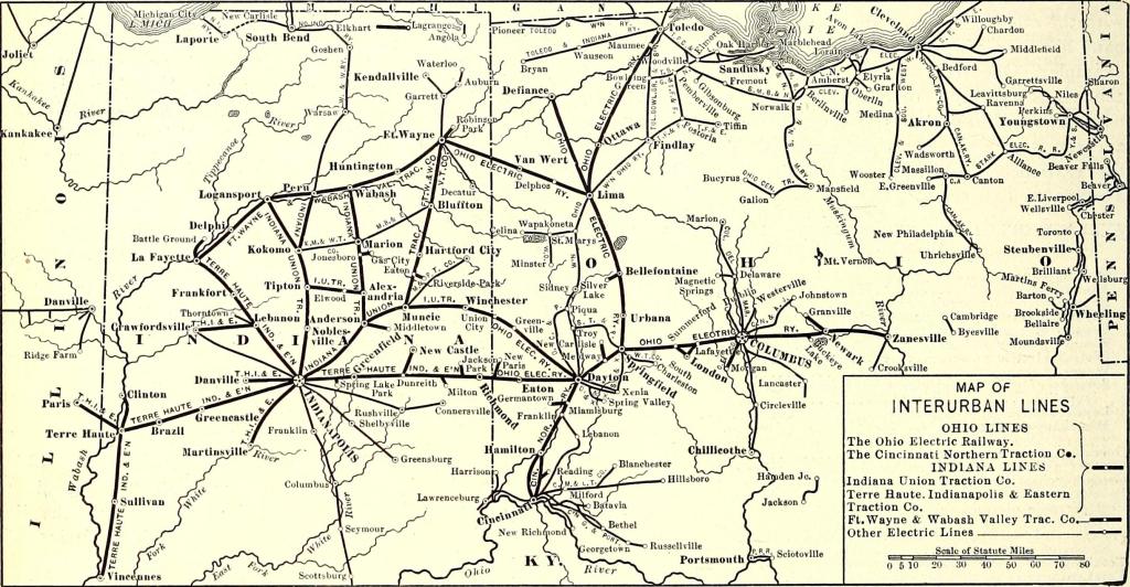
By 1930, however, most of the interurbans were gone, with a few surviving into the 1950s.
Why build a sophisticated electric street-car systems, only to use them for a short-period of time, and replace them with cars and trucks?
Well, the most obvious answer is that the mass production of gasoline-powered private and public transportation provided another form of transportation for people and provided a highly lucrative means of generating wealth for the big corporations involved in the transportation industry.
Non-polluting and low-fare electric-streetcar-systems were simply no longer needed or wanted.

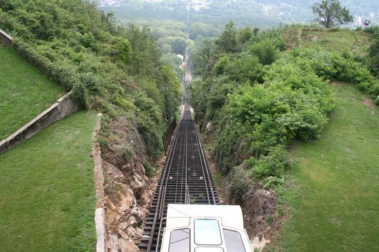
I mentioned the history of incline railways in Pittsburgh and Cincinnati previously, and like all the other rail infrastructure, they have had a tendency to be made to go away.
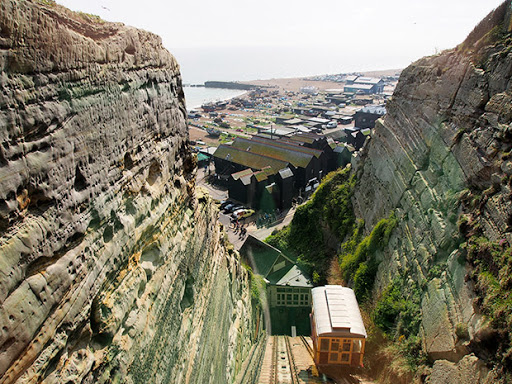
Also, known as funiculars, incline railways are a transportation system that uses cable-driven cars to connect points along a steep incline, using two counterbalanced cars connected to opposite ends of the same cable.
Besides the two in Pittsburgh, operational funiculars today include:
The Look-out Mountain Incline Railway in Chattanooga Tennessee, said to have been constructed in 1895…
…the Budapest Castle Hill Funicular in Hungary, said to have opened in 1870…

…and the East Hill Cliff Railway in Hastings, England, said to have opened in 1902.
But in many places, I am sure, like Incline Road on the Isle of Portland in southern England, the memory of an incline railway was retained in the name of what is today a road.
Then there is the underground rail infrastructure, which is also the same all over the world.
The London Underground is said to be the oldest underground railway system in the world.
We are told the idea of an underground railroad linking the City of London with the urban center came up in the 1830’s, and in 1854, the Metropolitan Underground Railway was granted permission to build it.
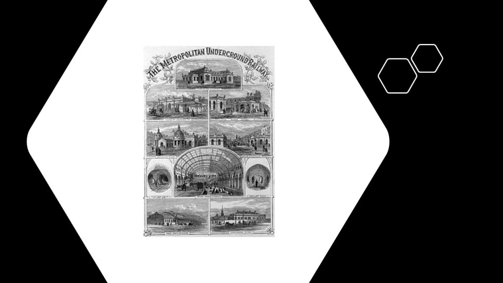
Underground operations were said to have started in January of 1863 between Paddington and Farringdon, using gas-lit wooden carriages hauled by steam locomotives.
Does that sound plausible? And gas-lit carriages underground? What about ventilation? Would this need have been accounted for in the mid-1800’s according to the history we have been taught?

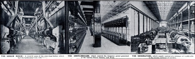
As time went on, the Lots Road Power Station was said to have been built between 1902 and 1904 to power the newly created Great Northern, Piccadilly, and Brompton Lines.
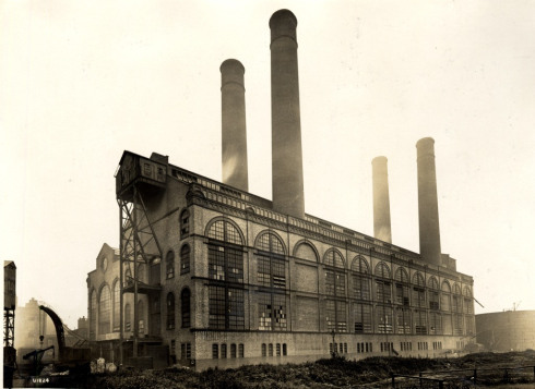
It was claimed to be the largest power station ever built, and eventually powered most of the railways and tramways in the Underground Group.
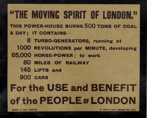
So we aren’t even out of the horse-and-buggy era when it was said to have been opened in 1904, with the mass production of automobiles not starting until 1908 with the Model T Ford, and yet we have the technology to build sophisticated electrical machinery generation like this?
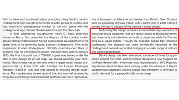
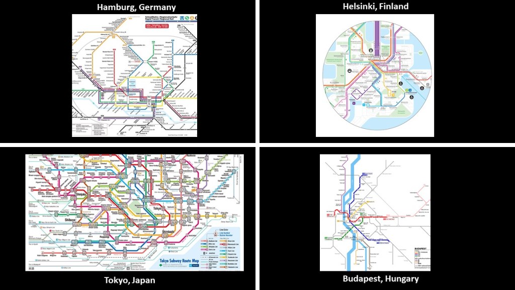
This is a map of the London Underground presented by Harry Beck, an engineering draftsman, in 1931.
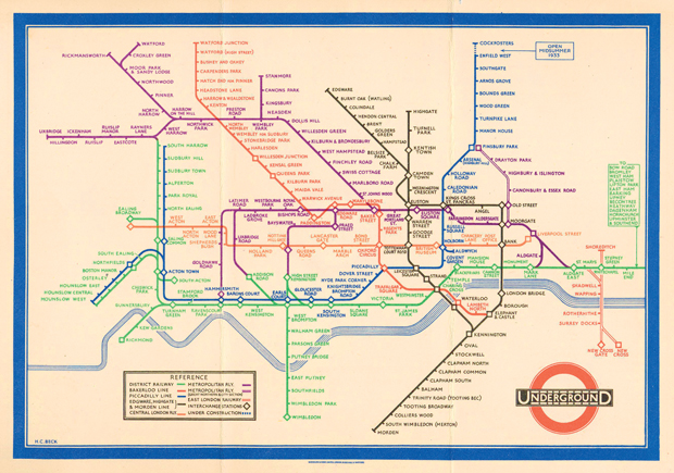
His design is based on the principle of electrical circuit diagrams.
Power circuits transfer and control large amounts of electricity.
Could the builders of the London Underground have possibly created gigantic power circuitry, starting in a haphazard way in 1854 onward, with the creation of the Metropolitan Underground Railway?
Not only that, the different-colored lines or routes found in the underground systems of the world – red, blue, green, yellow, orange, etc – also denote different meanings in electrical circuitry, which each color has a different function.
Do these electric transportation systems and networks somehow function as electrical circuits in their own right in the original physical lay-out of the earth’s grid system, and do not just pertain to the sophisticated electrical circuitry it takes to run them efficiently, day-in and day-out.
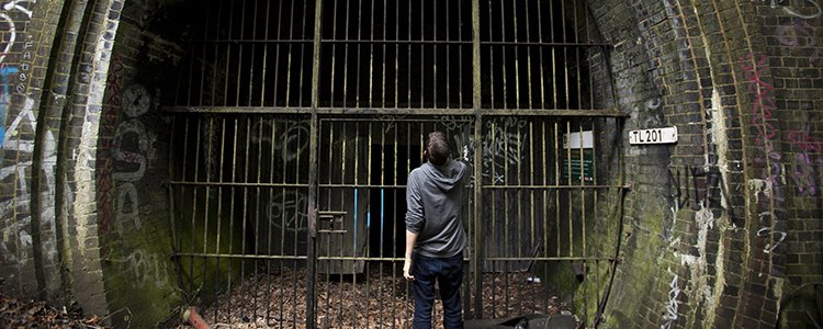
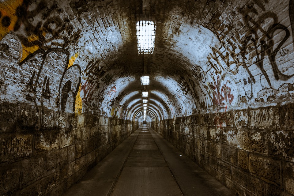
There are numerous abandoned underground tunnels and stations, not only in London, but in major cities around the world.
Of countless examples, this is one of London’s many abandoned subway tunnels…
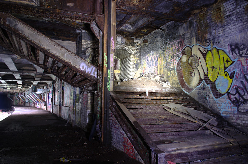
…and this one is in Budapest, Hungary…
…and this one in Glasgow, Scotland.
We are told that Glasgow in Scotland has the third-oldest underground rail system in the world, opening on December 14th, 1896.
The fifteen stations of the subway are distributed over a 10-kilometer, or 6-mile, circuit of the West End and City Center of Glasgow, with eight stations to the north of the River Clyde, and seven to the south. There are two lines: an outer circle running clockwise, and an inner circle running counter-clockwise.
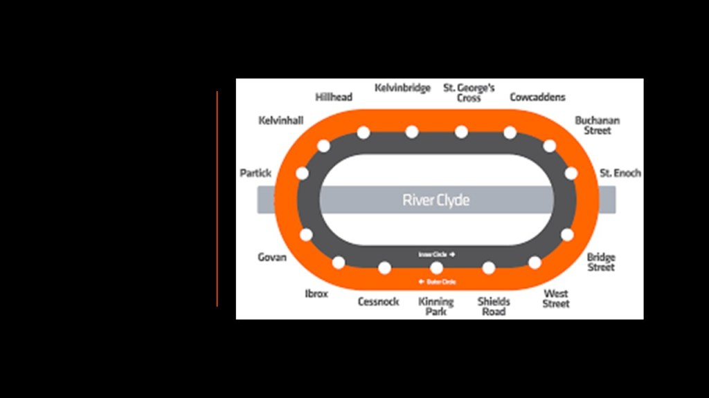
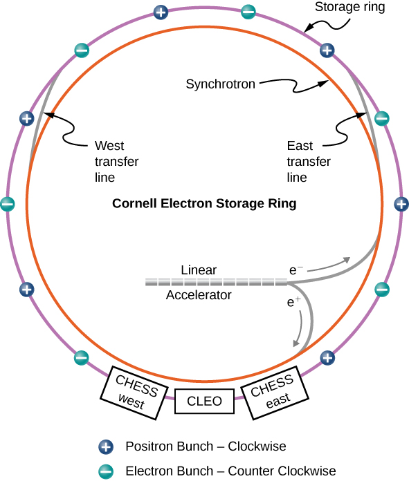
This graphic came up when I searched for “particle accelerator diagram,” showing counter-rotating beams in a circular accelerator, in comparison with the Glasgow subway’s outer and inner circle running in opposite directions from each other.
I definitely think there is more going on with these underground rail systems than anything we have ever been told about them.
The last type of electrical circuit infrastructure I am going to talk about in this post is the function of Cathedrals as “diodes.”
A diode is a semi-conductor device with two terminals that conducts current in primarily one direction.
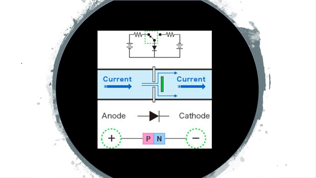
An electrode is an electrical conductor used to make contact with a non-metallic part of a circuit.
The cathode of the electrode is where a conventional current departs a polarized electrical device and the anode electrode is where a conventional current enters the polarized electrical device.
Electrical polarity refers to the two types of poles – positive and negative, representing the electric potentials at the ends of a circuit.
Conventional current describes the direction in which positive charges move, from the positive pole to the negative pole.
Electrons flow from negative to positive.
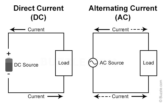
In a direct current (DC) circuit, current flows in one direction only.
In an alternating current (AC) circuit, the two poles alternate between negative and positive, and the current reverses periodically.
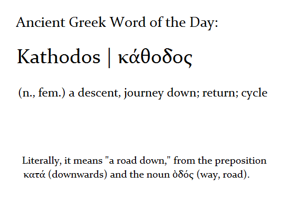
The Greek words “kathados” or “kata” mean “descent” or “down.”
“Hedral” refers to a 3D geometric solid.
Cathedrals function as acoustic/frequency/energy resonators.
Resonators are used to either generate waves of specific frequencies or to select specific frequencies from a signal.
Let’s look at several aspects of the function of cathedrals as frequency-generators and transmitters.
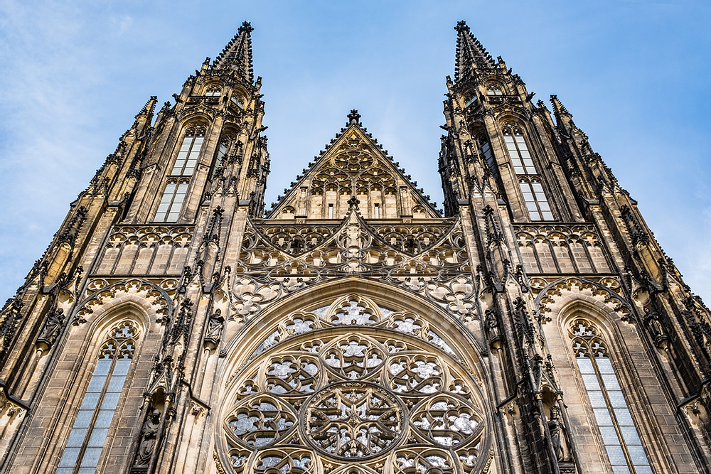
When I was reading an article about “Elliptical Polarization,” I encountered the diagram on the left showing the efficiency in decibels of the axial ratio of two antenna, and the shapes formed in the graph immediately brought this common shape of windows in cathedrals on the right.
Were these windows actually functioning as antennae?

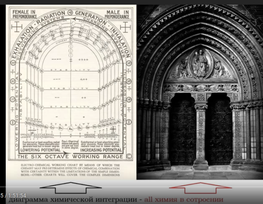
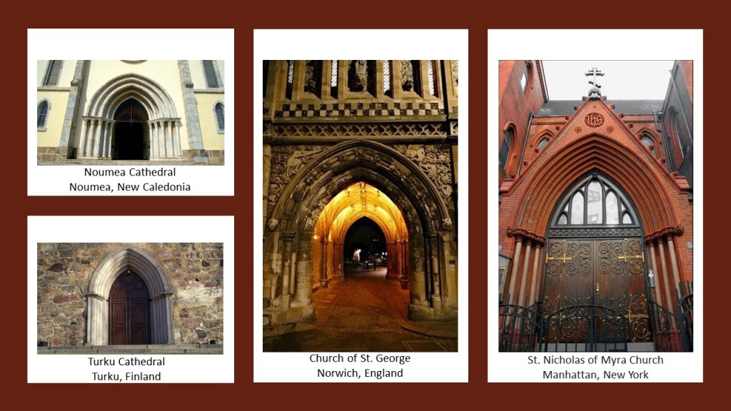
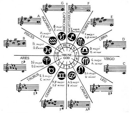
Then there is this Walter Russell diagram on the left and cathedral door n the right showing what looks to be a relationship between cathedral doors and octaves, which are the intervals between one musical pitch and another with double its frequency.
This shape of doors is found at cathedrals and churches said to have been built all over the world in different centuries, with the Noumea Cathedral in New Caledonia in the South Pacific said to have been built between 1887 and 1897; the St. Nicholas of Myra Russian Orthodox Church in Manhattan, New York, said to have been built in 1883; the Church of St. George in Norwich, England, said to have been built in the 1100s; and the Turku Cathedral in Turku, Finland, said to have been consecrated in 1300.
Not only that, Cathedral Rose windows look like the cymatic patterns of musical notes.

With the massive organ pipes surrounding the cathedral rose window, it appears as though this was a musical system designed to generate waves of specific frequencies, like Solfeggio frequencies, through this type of window.
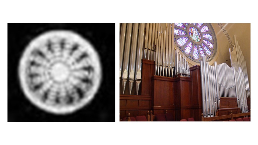
Solfeggio frequencies make-up the ancient six-tone scale used in sacred music, like, for example, Gregorian chants and Tibetan singing bowls.
Each solfeggio tone is a frequency that can be used to balance one’s energy and keep one’s body, mind, and spirit in harmony.

This is the St. Mary of the Mount Church on the edge of Mount Washington in Pittsburgh, Pennsylvania.
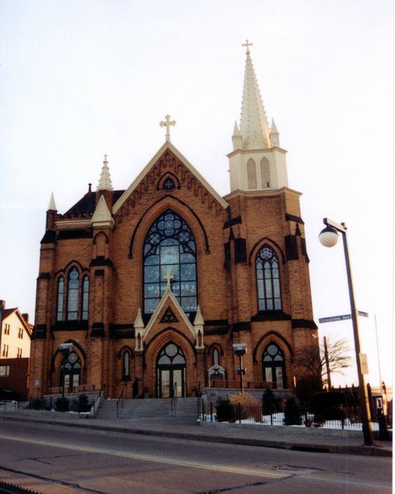
The windows at the front of the church here also resemble in appearance the patterns of some hydrogen wave functions.
Could this type of window be connected to atomic wave functions?

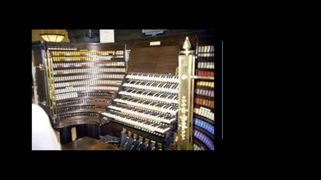
Then, there is the pipe organ found in cathedrals, a musical instrument that produces sound by driving pressurized air through organ pipes selected from a keyboard.
In biology, what is called an organ is a collection of tissues that structurally form a functional unit specialized to perform a particular function, from the Latin “organum,” meaning an instrument or tool.

A pipe organ has one or more keyboards played by the hands…
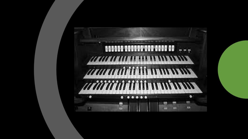
…and a pedal keyboard played by the feet, like this 30-note keyboard…
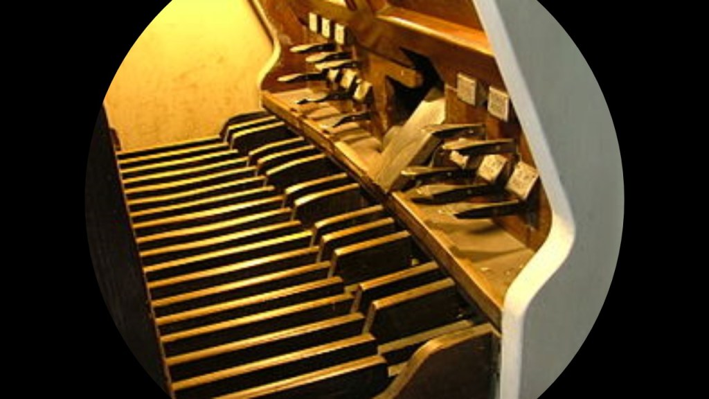
…and each keyboard contains its own division, or group of stops.
I have to wonder if pipe organs produced specific frequencies at specific times for specific reasons that had to do with the enhancement of the greater collective.
Cathedrals also have bells, like these at the National Cathedral in Washington, DC, the purpose of which, we are told, was to signify the time for worshippers to gather for a church service.
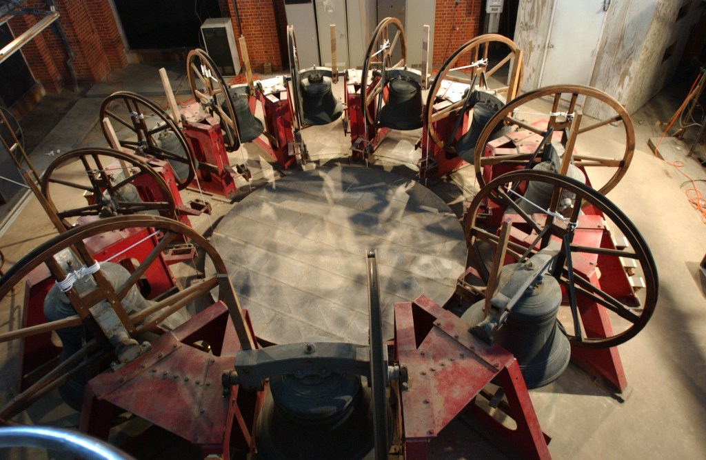
I have an interest in bell-towers, also known as carillons, and believe they were an integral part of an interconnected, functional system of a civilization that knew exactly how to utilize frequency and vibration in fundamental and harmonious ways.
There are a number of them in Florida.
This is the Bok Tower in the Bok Gardens at Lake Wales.
It is located on what is called Iron Mountain, one of the highest points on the Florida Peninsula.

The Bok Tower is also known as the “Singing” Tower.
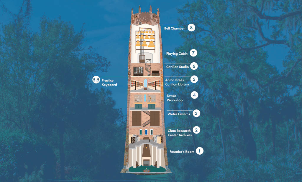
It was said to have been commissioned by Dutch immigrant and “Ladies Home Journal” magazine editor at one time, Edward Bok, and said to have been built between 1927 and 1929, when it was dedicated by President Calvin Coolidge.
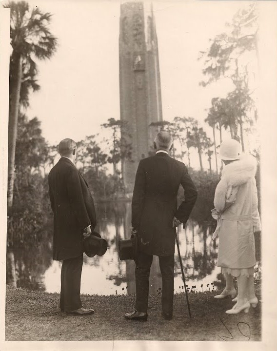
Edward Bok died in 1930, the year after the completion of the bell-tower that carries his name.
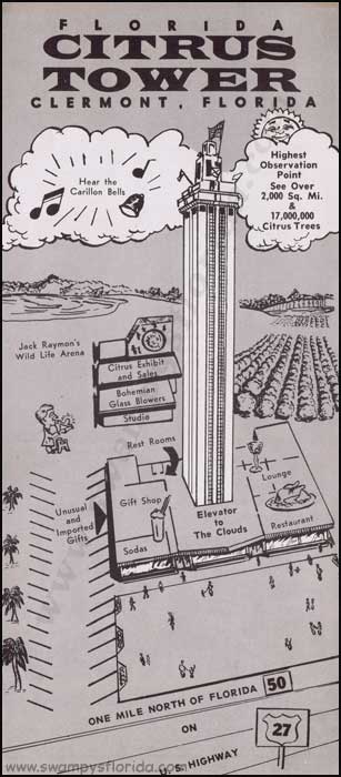
The Citrus Tower in Clermont, Florida, near Orlando, was said to have opened in 1956, and was a big, pre-Disney World, tourist attraction in its hey-day.
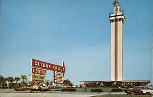
…and is also a bell-tower like the Bok Tower.
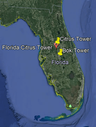
These two bell-towers line-up with each other in Central Florida. I will have to do some more research on this subject in the future and see what more I can find out about alignments of these bell-towers with each other.
What was the purpose of these massive bell-towers reaching up to the clouds for the original civilization?
Were these tall generators of healing and harmonious frequencies for the benefit and balance of all of Creation?
Other infrastructure like old railroad terminals have the same characteristics as cathedrals.
This is the old Union Station in Louisville, Kentucky, that looks like a cathedral complete with a rose window.
And how many small towns have this story?
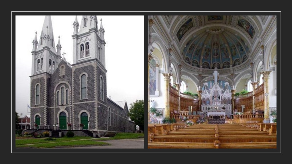
Information about this church was forwarded to me from Francois in Quebec, about the big church in his small town.
The town of Ste. Thecle in Central Quebec has a massive and ornate church built between 1903 and 1905 under the direction of the Catholic priest Maxime Masson, who was called the main architect of the religious buildings in what has always been a small community.
The 2011 population of Ste. Thecle was listed as just under 2,500 people.
The destruction of the Earth for profit, as well as destruction for its own sake, and the eradication of Humanity through genocide has been going on hand-in-hand for quite some time now.
Humankind has been given plenty of distractions and things to argue about to keep us focused on them instead of a real problem – malevolent beings that found a way to incarnate in human form, and take over all the wealth and power of the Earth for themselves, and seek to do away with Humanity as we know it and replace us with man-machine interface vessels.
The majority of Humanity doesn’t realize this is the direction we have been led in by these malevolent forces who have absolutely no regard for Human life except for how we can benefit them.
Trans-Humanism is a very real goal of theirs.
First they devised a way to hijack the positive timeline of Humanity, after which time they have been scheming to hijack our souls.
While we have been asleep, pure evil has been having its way with us.
If they couldn’t control us, they didn’t want us to be.
Welcome to the Great Awakening!


do offer any other services.do you do readings.
LikeLike
Thank you for asking, but no I don’t do readings. The only other thing I do is that I am an educator and publisher on a new monthly on-line platform called unguruyourlife.com. There is a monthly subscription membership, which offers access to everyone and everything on the site, or a free-level membership which offers access to various social media groups on the site, including mine. I appreciate your donation on my website very much – thank you so much!
LikeLike
Thank you for your service to humanity . And made the great cosmic Mother bless you and all that you do.
LikeLike
Many thanks and blessings to you as well!
LikeLike
What happens when someone interferes with the flow of currency, like a robbery? They get charged!
LikeLiked by 1 person
Hi Michelle, Thank you so much for your great work! It looks to me like there may be a triangularity with the southern end of Grosse Ile, MI (42.107827071426236, -83.17954557451151); Ft Wayne, Detroit (42.29934241809812, -83.09604638195688); and Belle Isle, where there is an octagonal lighthouse made of marble at the eastern end (42.34051819412996, -82.97877230966306). Belle Isle’s western end has a similar triangular feature to Grosse Ile’s airport. All three are in or on the Detroit River.
LikeLike