
I am going to take a tour of the locations of historic star forts and places where there were trolley parks of a by-gone era in Eastern New York, starting at the southern end of Lake Champlain and heading directly south along the Hudson River Valley into the Upper and Lower New York Bays in this video.
I happened into the area when I was researching the Saratoga Springs Race Course, its relationship to airports in the area, as well as the presence of healing springs, railroad, and once upon a time, there was a trolley-car line as well as a “Fort Saratoga.”
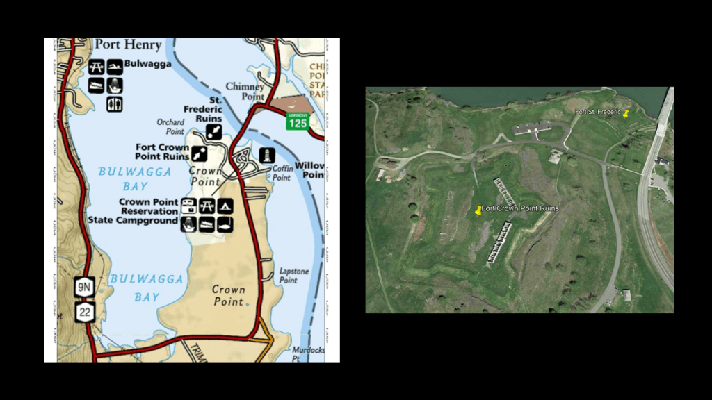
I am going to begin with Fort St. Frederic and Fort Crown Point at the southern end of Lake Champlain, which lies between the states of New York and Vermont, and extends up into the Canadian Province of Quebec.
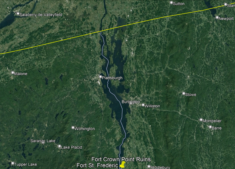
Fort St. Frederic was said to have been constructed by the French starting in 1734 on Lake Champlain at Crown Point, New York, in order to control the lake and to secure the region against British colonization, but that it was already destroyed by 1759 before the advance of a large British Army.
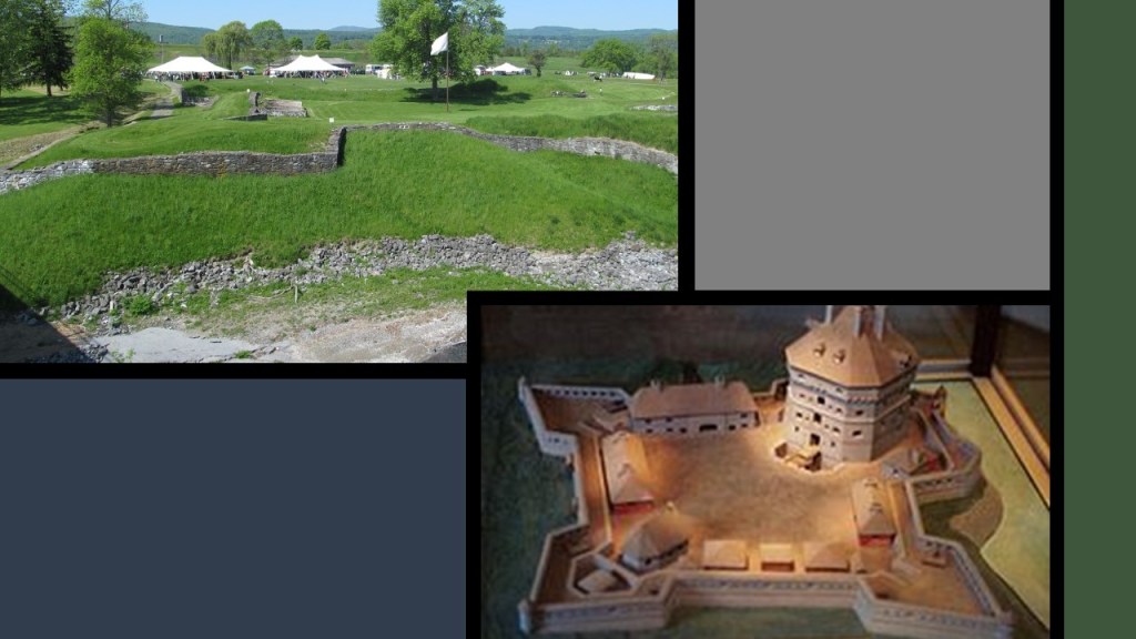
Then, the British were said to have built the much larger Fort Crown Point next to the ruins of Fort St. Frederic in 1759, and this fort fell into ruins after the American Revolutionary War.

The ruins of both of these star forts have been preserved on the grounds of the Crown Point State Historic Site since 1910.
Fort Ticonderoga is 116-miles, or 186-kilometers, southeast of Crown Point State Historic Site.

Fort Ticonderoga was said to have been built by the French between 1755 and 1757 during the French and Indian War, and was of strategic importance during the 18th-century colonial conflicts between the British and the French, and played an important role during the American Revolutionary War.
It ceased to be of military value after 1781, we are told, and the U. S. Government allowed it to fall into ruin.

Fort Ticonderoga was purchased by a private family in 1820, and it became a tourist stop, and today a foundation operates the fort as a tourist attraction, research center and museum.

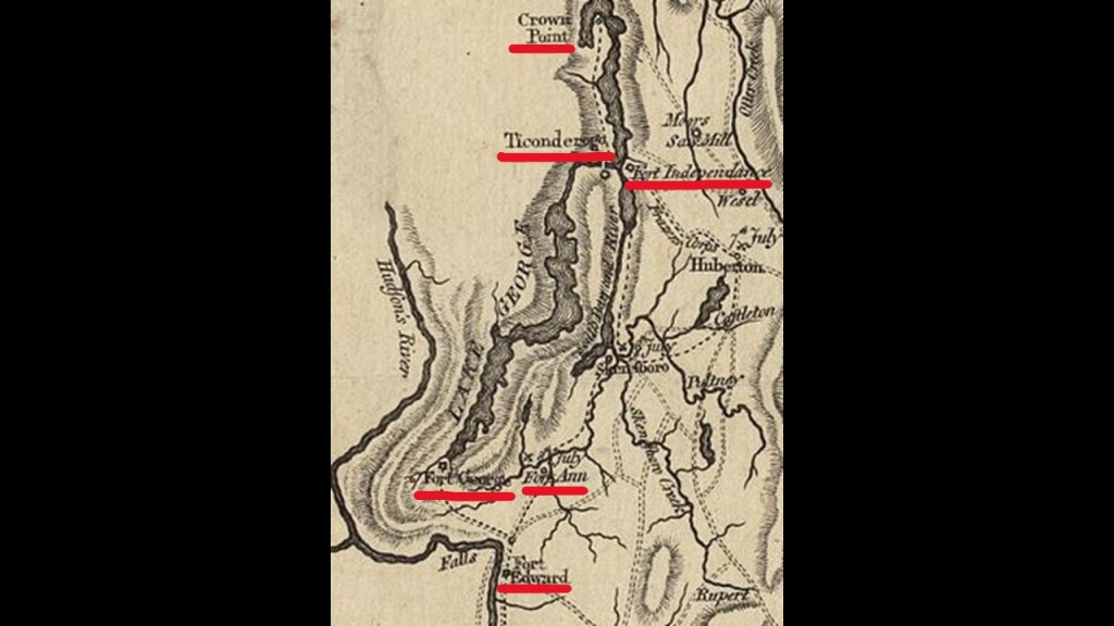
I came across this circa 1780 map showing a number of other historical forts in this part of New York State, so there are more named here than what I was first aware of when I started doing the research here.
Also, what looks to be the beginning of the Hudson River is on the left-hand-side of the map, and to the left of Lake George which is below Crown Point and Fort Ticonderoga.
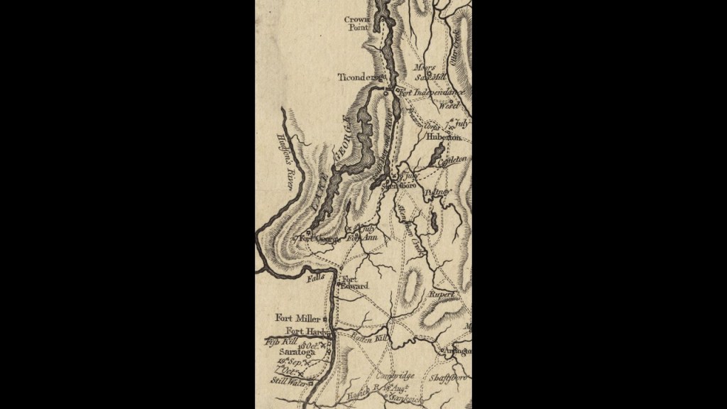
The upper part of the map is showing Fort Independence directly across from Fort Ticonderoga.
At the other end of Lake George, which lies between Forts Ticonderoga and Independence, we find a Fort George and Fort Anne showing on this map.
Fort George on Lake George was said to have been built in 1755, destroyed in 1777 and abandoned in 1780.
Fort Anne was said to have been built in 1757, and was the location of the American Revolutionary War Battle of Fort Ann, fought on July 8th of 1777 between Continental forces in retreat from Fort Ticonderoga and General Burgoyne’s larger British army as part of the Saratoga campaign, and called a British victory.
I will be talking about Fort Edward on this map shortly.
Not showing on this map on the southern end of Lake George along with Fort George and Fort Anne is Fort William Henry, said to have been built in 1755 by the British during the French and Indian War as a staging ground for attacks against the French position at Fort St. Frederic back up at Crown Point.
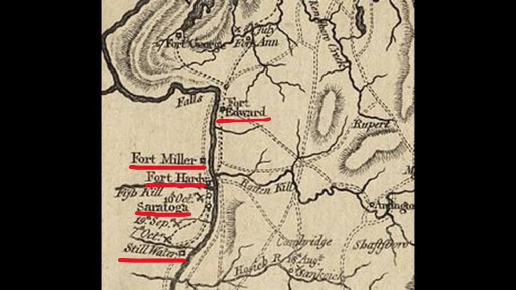
Picking up at Fort Edward on the Hudson River from the upper-half of the map, the lower-half of the 1780 map shows Fort Miller, Fort Hardy, Saratoga, and Still Water along the Hudson River.
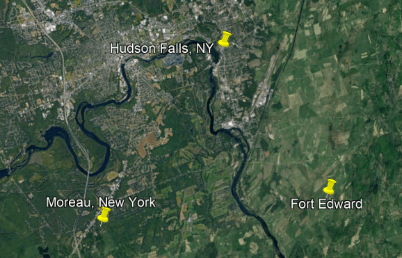
Fort Edward is located just below the towns of Hudson Falls and Moreau.
There’s not much left of Fort Edward to speak of.
There is a marker at the intersection of Route 97 and Route 4, near the Anvil Restaurant and lounge, that marks the site of the northeast bastion of Old Fort Edward, part of the outworks of the fort.

In the middle of what is now a residential neighborhood, there is a marker designating part of what was the old moat of Fort Edward…

…and in a park that overlooks a bend in the Hudson River, there is a big stone with a plaque marking the historic location of Old Fort Edward.

The nearby town of Moreau appears to be an interesting place by just glancing at the Google Earth screenshot.
The arrow is pointing to a structure in the landscape that looks like it could have been a star fort at one time.

…and the towns of Moreau and Hudson Falls are connected by the Fenimore Bridge, which was said to have been constructed in 1906 by the Union Paper and Bag Company as the company had plants in both places.
With fifteen arch spans, roadway, sidewalk and a standard gauge railway track, at one time, it was considered the longest, multiple-span, reinforced concrete arch bridge in the world.
It was closed to traffic in 1989 after it was deemed to be structurally-deficient, and a replacement bridge was built next to it.
Like Fort Edward, Fort Miller below it on the Hudson River is remembered by an historical marker, erected by the State Education department in 1940, and simply says it was built in 1755 by “Col. Miller.”

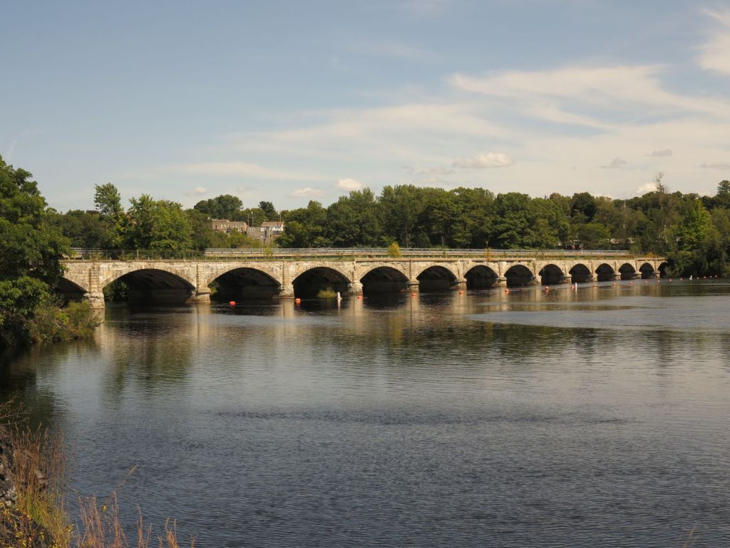
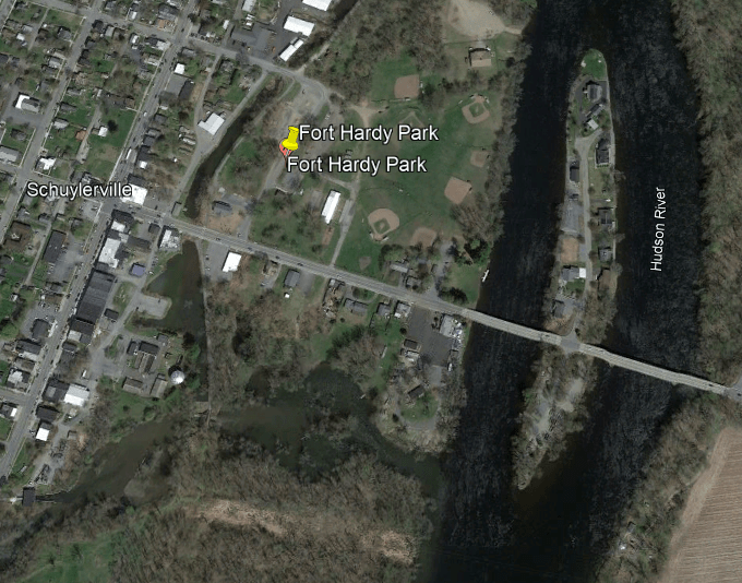
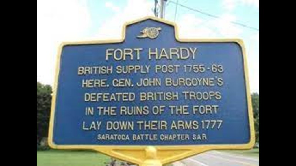
Fort Hardy in Schuylerville, New York, came next going south on the Hudson River, where today there is a “Fort Hardy Park” in town.
Fort Hardy was the location of the British General Burgoyne’s surrender following the Battle of Saratoga, when the Americans defeated the British Army in October of 1777, and a turning point in the Revolutionary War.
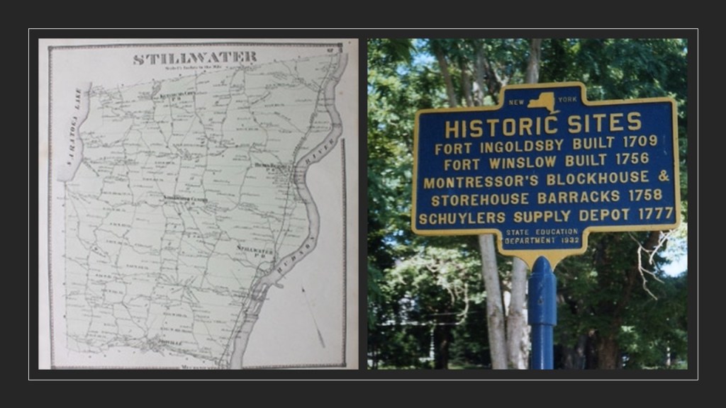
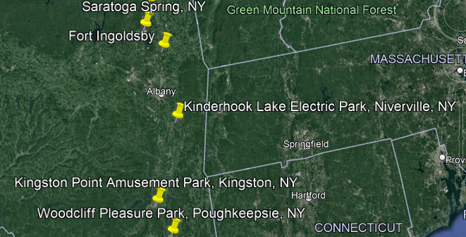
Below Fort Hardy, there was an historical Fort Saratoga on the Hudson River, and then a short-distance below Fort Saratoga were Fort Ingoldsby and Fort Winslow, both in Saratoga county in Stillwater, New York.
Between Fort Ingoldsby near Saratoga Springs and the next cluster of three historic star forts at West Point, New York, on the Hudson River, there were four historic trolley parks.
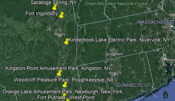
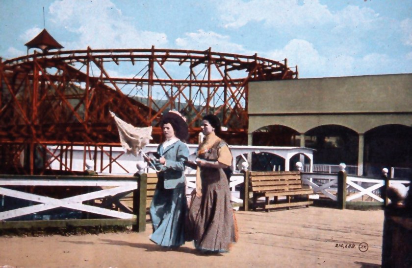
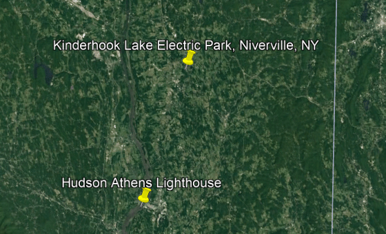
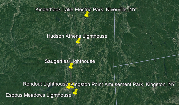
First, we come to Niverville, New York, 68-miles, or 109-kilometers, south of Fort Ingoldsby on the Hudson River, where Electric Park was located on Kinderhook Lake.

The Electric Park there was described as the largest amusement park on the east coast between Manhattan and Montreal during its run from 1901 to 1917.
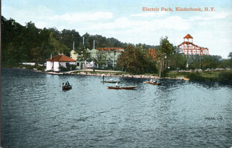
We are told this Electric Park was created by the Albany & Hudson Railroad Company in order to increase ridership on weekends.
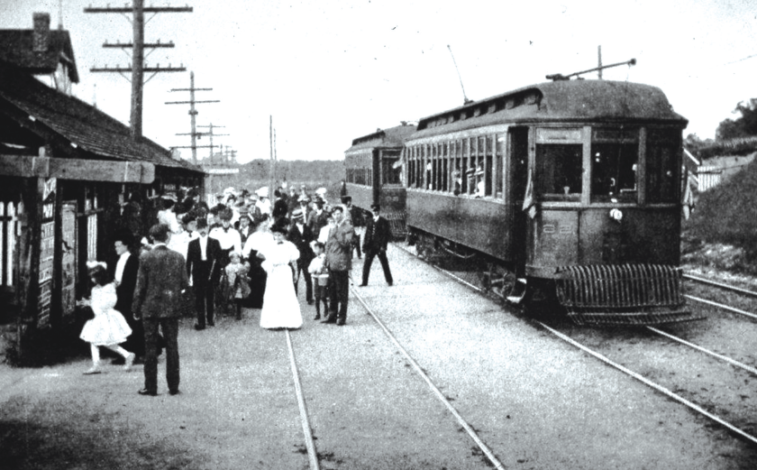
The reasons given for the closure of the Electric Park of Niverville in 1917 was that the popularity of automobiles no longer restricted people to rails and river steamer transportation; World War I; and high insurance premiums due to the number of trolley parks that had burned down.
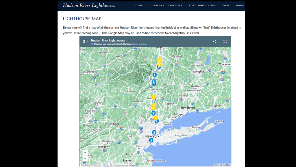
The Hudson Athens Lighthouse is located below Niverville.
It was said to have been built between 1873 and 1874, becoming operational in 1874.
In 1967, New York Governor Nelson Rockefeller established the Hudson River Valley Commssion, which suggested that the United States Coast Guard deed over or lease lighthouse facilities to non-profit historical groups to ensure their preservation and upkeep, and this lighthouse was the first to be tried through such a program, and in 1984, the lease for the lighthouse was first turned over by the Coast Guard to the Hudson Athens Lighthouse Preservation Society.

The Saugerties Lighthouse just north of Saugerties, New York, is below the Hudson Athens Lighthouse.

It was said to have been constructed in 1869, replacing an earlier 1838 lighthouse.
The Saugerties Lighthouse Conservancy purchased it in 1986 and restored it.
The conservancy manages the property, including offering two bed and breakfast rooms and public tours.

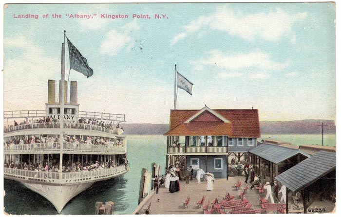
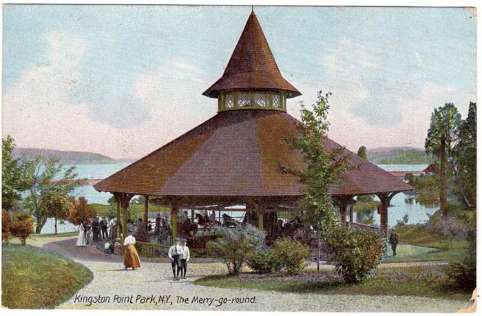
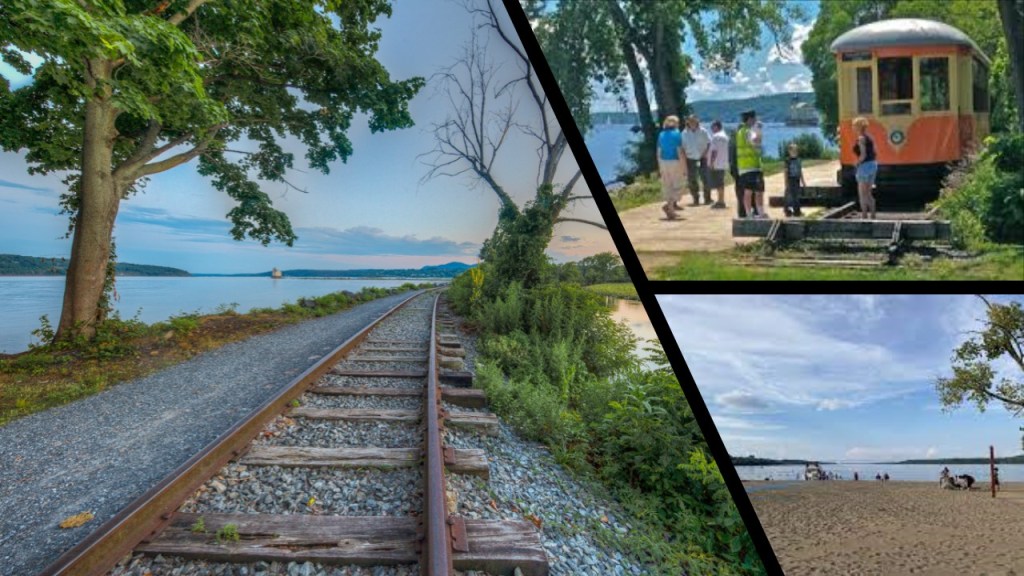
Next we come to Kingston, New York, where the historic Kingston Point Park and Rondout Lighthouse were located, 106-miles, or 171-kilometers, south of Fort Ingoldsby.

Kingston Point Park was said to have been built by Samuel Coykendall, the wealthy owner of the Cornell Steamboat Company and Ulster and Delaware Railroad.
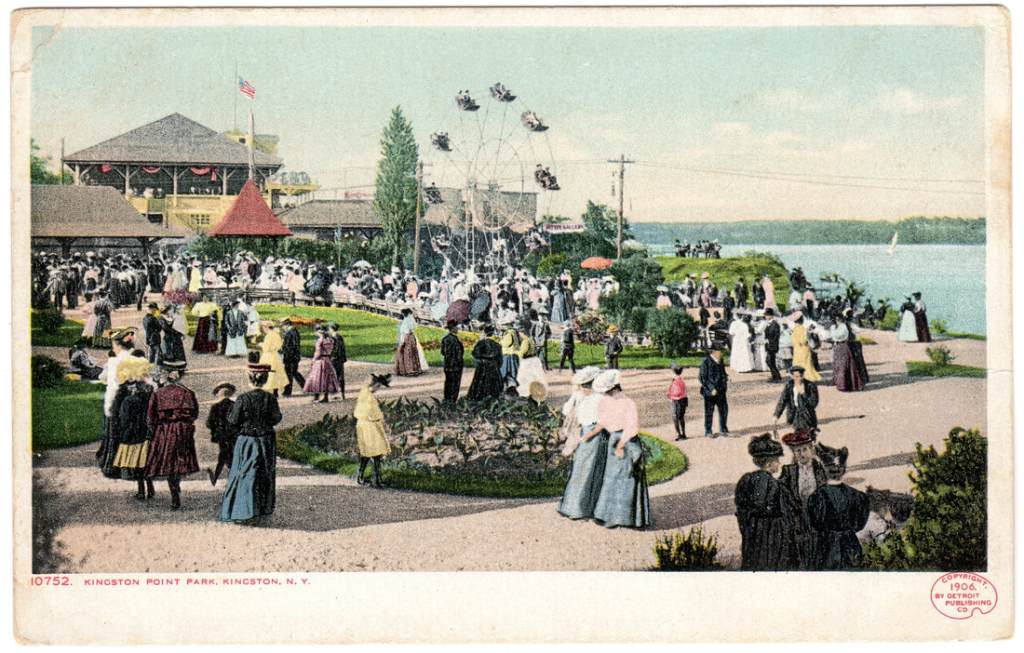
The stated purpose of the park was to serve as a steamboat landing for the Hudson River Day Line, and a place where trains and trolleys would take passengers into Kingston and the Catskill Mountains.
Kingston Point Park opened in 1896, and had a Ferris Wheel, Merry-go-Round, bandstand and boat rentals.
A fire in the 1920s destroyed most of the buildings.
All that remains today at the Kingston Point Rotary Park is a park-setting, beach, and trolley tracks.
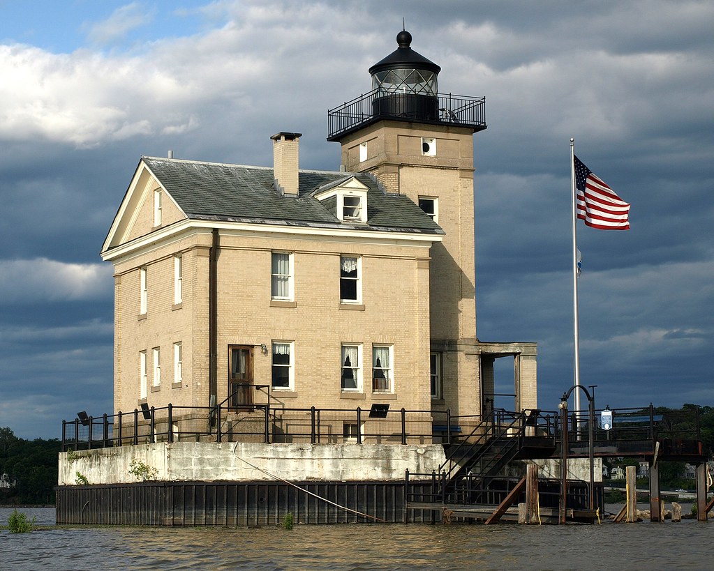
The Rondout Lighthouse in Kingston was said to have been built in 1915 to replace an earlier lighthouse constructed in 1867.
Rondout Lighthouse was transferred to the City of Kingston by the Coast Guard in 2002, and it is currently managed by the non-profit Hudson River Maritime Museum.
The Esopus Meadows Lighthouse is below Kingston on the Hudson River
Nicknamed “Maid of the Meadows,” the Esopus Meadows Lighthouse was said to have been completed in 1871 to replace a lighthouse that had been constructed in 1838.
Interesting to note that the lighthouse was described as having been built with a granite foundation on top of piles that had been driven into the riverbed.
The lighthouse was closed in 1965, and said to have fallen into a state of disrepair, especially the granite foundation, which we are told had begun to fall apart due to ice damage.
The “Save Esopus Lighthouse Commission” leased the lighthouse from the Coast Guard in 1990 in order to restore it, and took ownership of it in 2002.

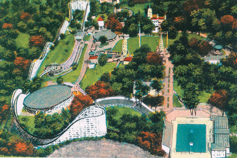
We come to Poughkeepsie next, 121-miles, or 194-kilometers, south of Fort Ingoldsby, where the Woodcliff Pleasure Park operated from 1927 to 1941.
It was the home of the Blue Streak roller coaster, the highest and fastest roller coaster anywhere during its time, and one of the largest swimming pools in the country.
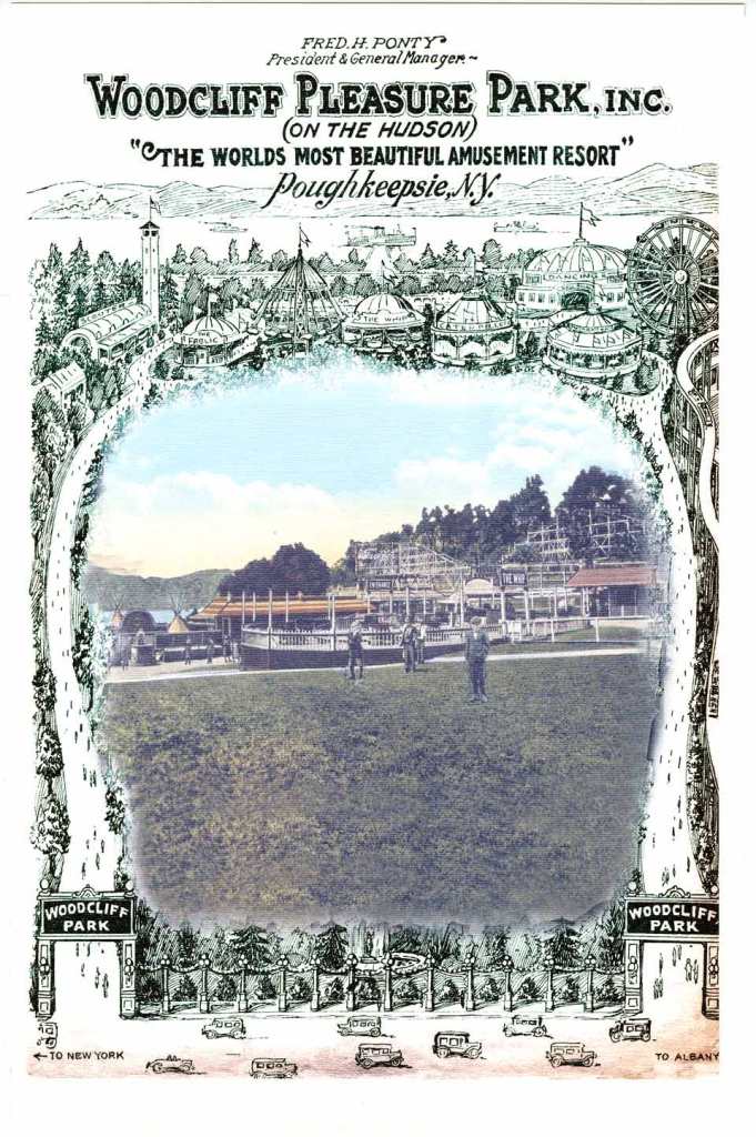
The Woodcliff Pleasure Park was said to fall on difficult times, and permanently closed in 1941.
The next historic trolley park we would have come to was the Orange Lake Amusement Park that was located 6-miles, or 10-kilometers, west of Newburgh, New York.

It was a place where people could enjoy fishing, boating, swimming and a pleasant walk.
The advent of the trolley line in 1886 was said to have increased the popularity of the park, leading it to become one of the most popular parks in the northeast.
We are told the president of the Central Hudson Steamship Company, former New York Governor Benjamin Barker O’Dell, Jr, and Board member of the Trolley Company, developed Orange Lake Park into a showcase, and added a roller skating rink, snack bars, a midway with games of chance, a Ferris Wheel and other rides, a beach for swimming, and boat rentals.
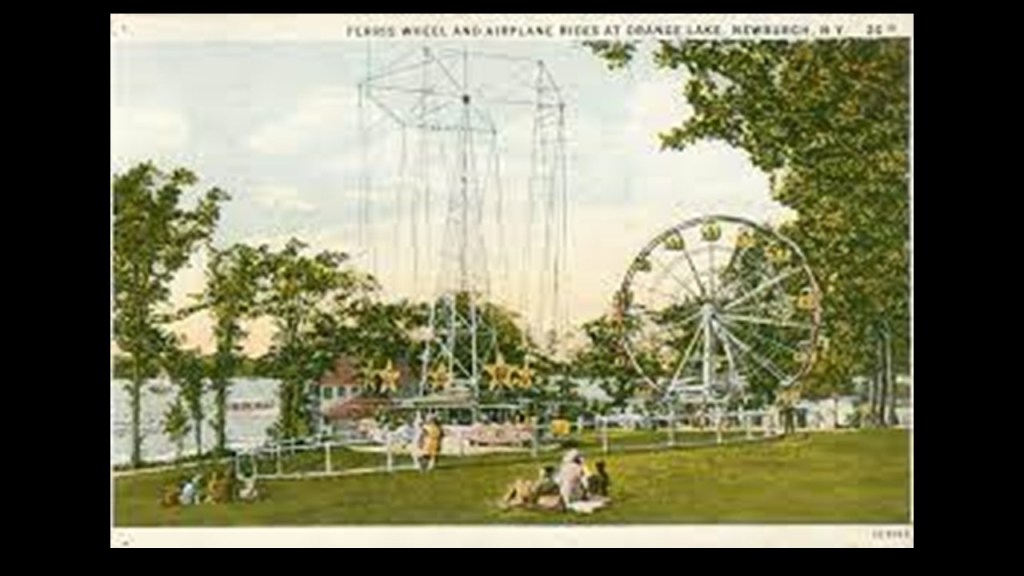
During the Great Depression, the Orange Lake Park was forced to close for a number of years.
It was eventually dismantled in 1941, and turned into a residential community with nothing of the amusement park remaining.

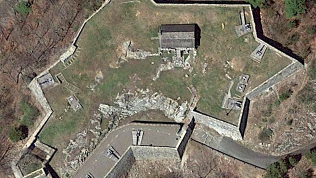
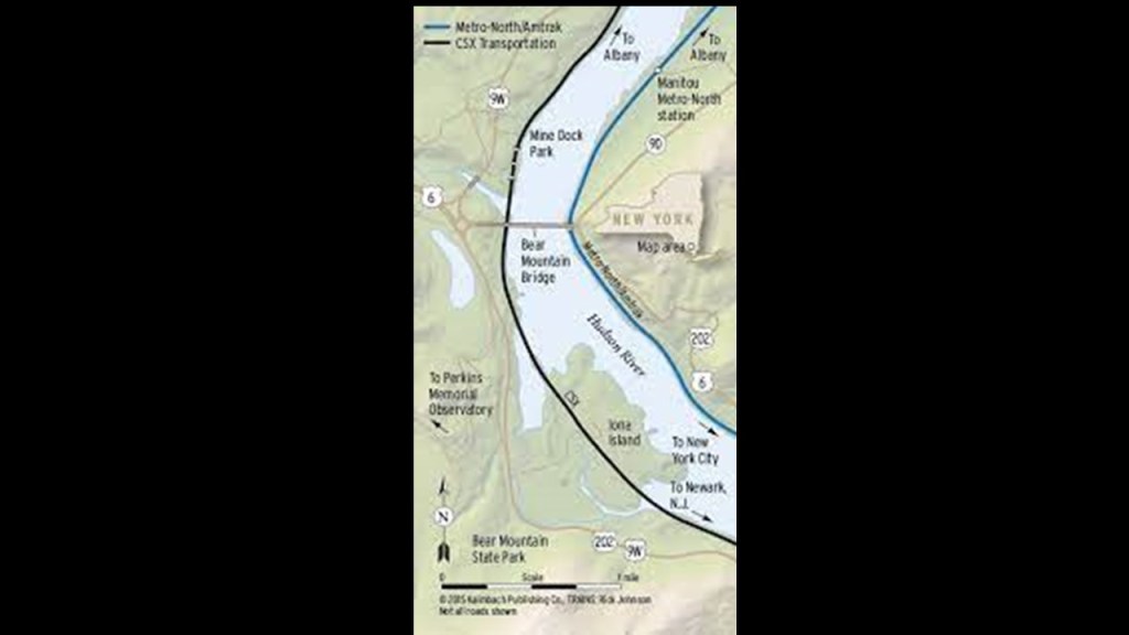
After leaving Orange Park and Newburgh, New York, we arrive at Forts Clinton, Putnam and Constitution clustered around the Hudson River at West Point.
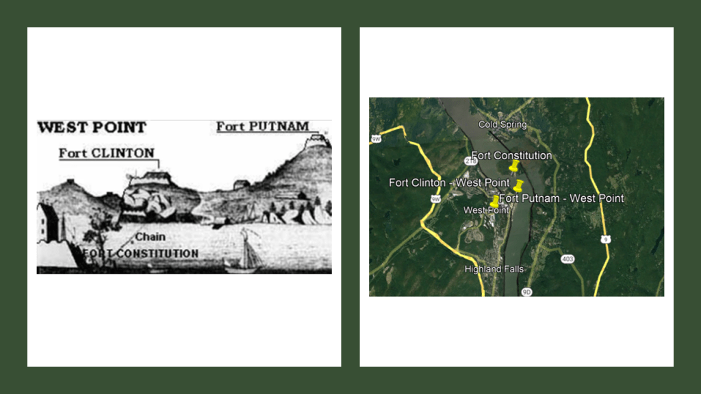
This location was called “The Turn” in the Hudson river, and where the 75-ton Great Chain was constructed, with the given reason of preventing British naval vessels from sailing upriver during the Revolutionary War between 1776 and 1778.
A…75…TON…chain…was constructed….during the American Revolutionary War?!
How could they have accomplished this according to the history we have been taught?


Fort Clinton was originally named Fort Arnold, as it was commanded by and named after Benedict Arnold before his betrayal to the United States and defection to the British Army.
The fort was subsequently named after Major General James Clinton.
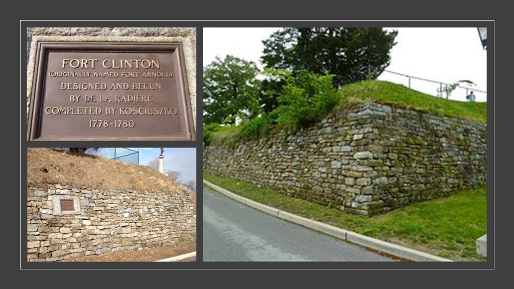
Fort Putnam was said to have been completed in 1778 with the purpose of supporting Fort Clinton.
Even though it was rebuilt and enlarged in 1794, we are told, it fell into disuse and disrepair as a military garrison, and was obsolete by the mid-19th-century.
Fort Constitution was Just a short-distance away across the Hudson River from Forts Clinton and Putnam on the West Point campus.
It was captured and destroyed by the British in October of 1777, and said to have been partially reconstructed by the American forces after it was abandoned by the British, and became one of the anchor points for the Great Chain across from West Point.
It was completely abandoned after the revolutionary War.

Also destroyed by the British in 1777, were the nearby Forts of Montgomery…

…and Fort Clinton at Stony Point, named after Brigadier General George Clinton of the New York Militia, and commander of the fort before it was captured by the British and destroyed.
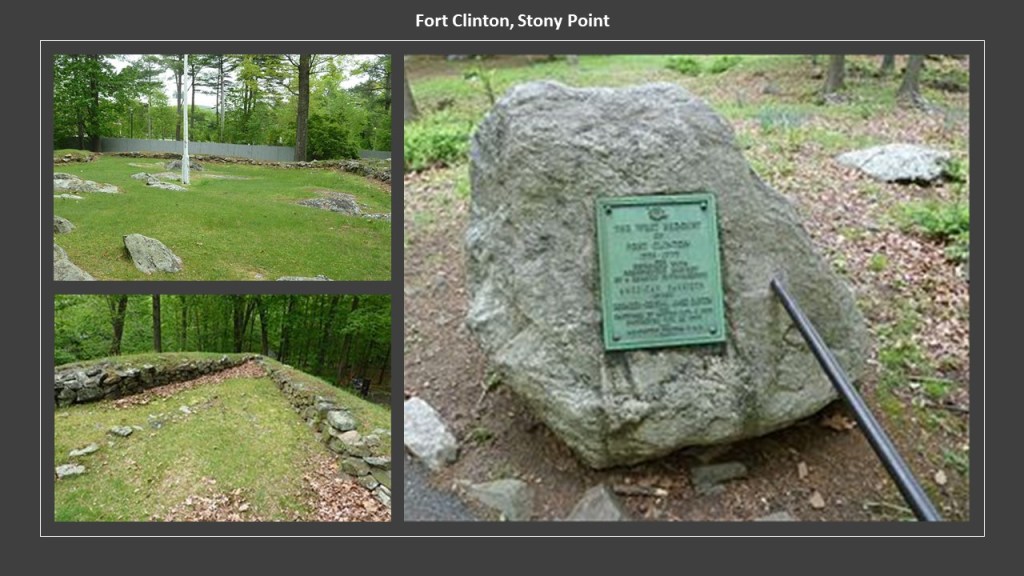
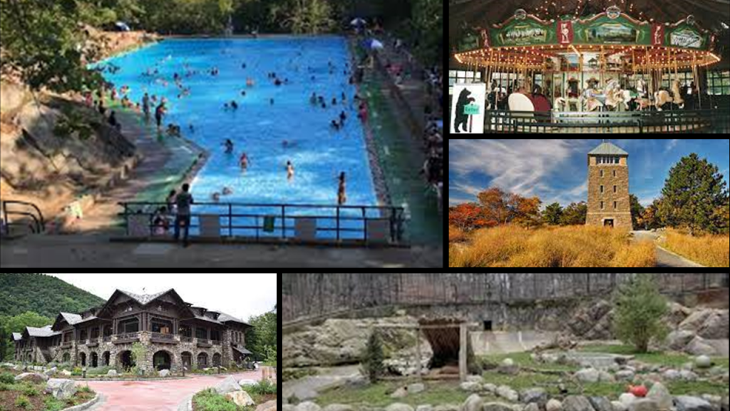
Fort Clinton at Stony Point is adjacent to Bear Mountain State Park.

Along with the variety of recreational opportunities to be found at Bear Mountain State Park, including biking, hiking boating, picnic facilities, swimming, and winter activities like cross-country skiing and ice skating, other places of interest in the park include the Perkins Memorial Tower, said to have been built in 1934; Trailside Museum & Zoo; the Bear Mountain Inn; a merry-go=round; pool and skating rink.
With regards to the history of the park, this is what we are told.
In January of 1909, the State of New York purchased a 740-acre tract of land at Bear Mountain, with plans to build Sing-Sing Prison there, but conservationists stopped the prison from being built.
Later that year, the newly-widowed Mary Averell Harriman, wife of Union Pacific Railroad President and American Financier Edward Henry Harriman who died in September of 1909, offered the state another 10,000 acres – and $1,000,000 – towards the creation of a state park.
American Progressive politician and businessman George W. Perkins, a partner in the J. P. Morgan Company and President of the Palisades Interstate Commission since 1900, with whom Mary Harriman had been working, managed to raise another $1.5-million from a dozen wealthy contributors, including John D. Rockefeller and J. P. Morgan.
The state matched the contributions with a $2.5-million appropriation, and Bear Mountain-Harriman State Park came into being in 1910, and managed by the Palisades Interstate Commission, which was formed in 1900 by New York Governor Theodore Roosevelt and New Jersey Governor Foster Vorhees, for the state reason of stopping the quarrying activities along the Palisades Cliffs of New Jersey.

Right away, a steamboat dock was built excursion for excursions to the Bear Mountain State Park and the West Shore Railroad Station was built near the dock.
Got to wonder what was really going on here with the involvement of all these super-wealthy, elite family names of Rockefeller, Morgan &Harriman ?!
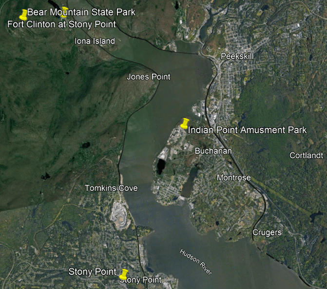
Shortly after leaving Fort Clinton at Stony Point on the Hudson River, we come to Buchanan, New York, the historic location of Indian Point Amusement Park.
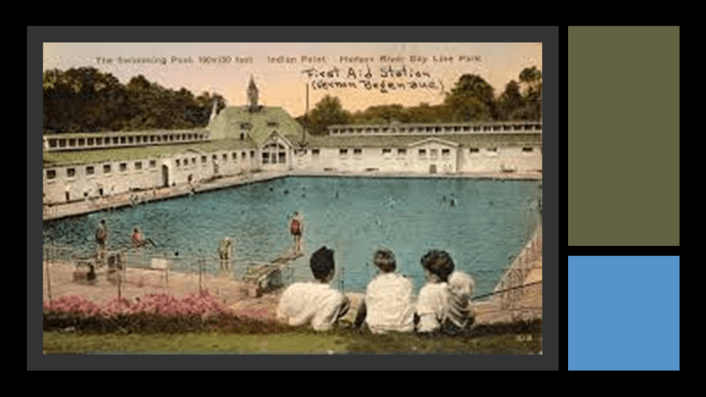
Indian Point Amusement Park was said to have been created in 1923 on a former farm by the Hudson Day Line, the premier steamboat line on the Hudson River from the 1860s through the 1940s, as a recreational park for its passengers as a rival for the popular park at Bear Mountain.
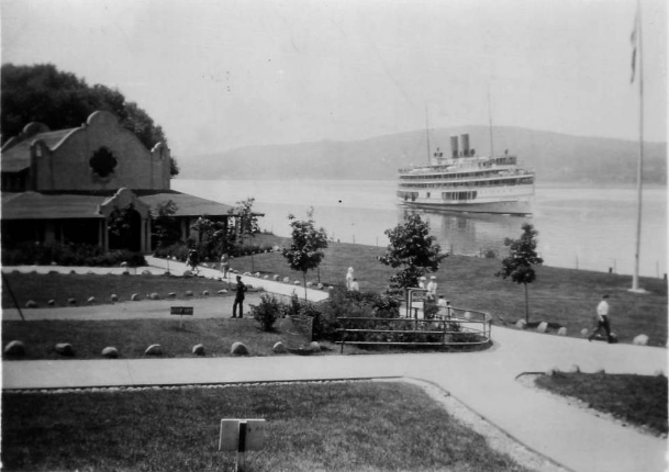
The Indian Point Park had a cafeteria, picnic facilities, baseball diamonds, rides and games, dance hall, beer hall, miniature golf, swimming pool and speedboat rides.
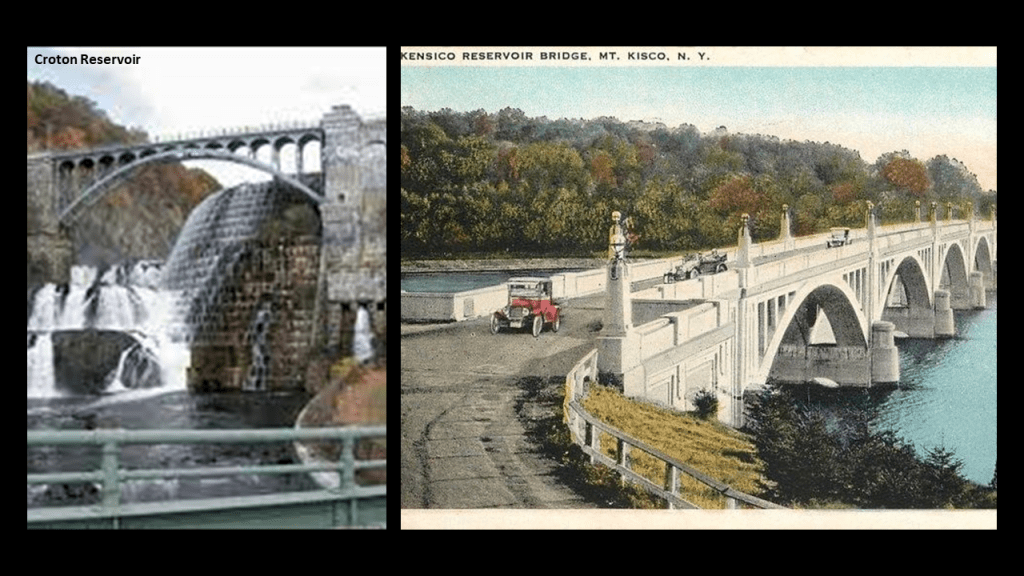
The property backed up to the Croton and Mt. Kisco Reservoirs that provided water to New York City.
From 1923 to 1948, the Hudson Day Line operated Indian Point Park, at which time the park was closed.
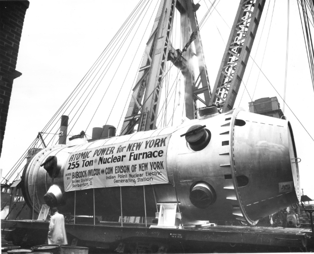
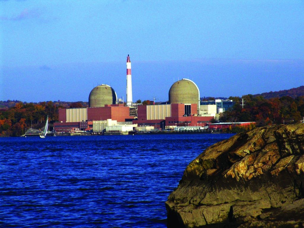
It reopened in 1950 under new management and operated for a few more years until it closed in the mid-1950s and the property was purchased by Consolidated Edison Gas and Electric Company for the Nuclear Power Plant which opened in 1962…
…and which was in operation until April 30th of 2021 when Indian Point Energy Center was permanently closed.
Before its closure, the two reactors there provided an estimated 25% of New York City’s electrical power usage.
It is interesting to note that there is a feature across the Hudson River from Indian Point, in the actual town of Stony Point, that looks like it could have been a star fort at one time, just like what we saw back in Moreau, New York.

Before leaving the town of Stony Point, there is a light house here to show you.

The Stony Point Lighthouse stands on the grounds of the Stony Point State Historic Site, said to be the location of the 1779 Battle of Stony Point during the American Revolutionary War.

We are told the Stony Point Lighthouse is the oldest lighthouse on the Hudson River, having been built in 1826 to warn ships away from the rocks of the Stony Point peninsula.
It was decommissioned in 1925; acquired by the Parks Commission in 1941, and added to the National Register of Historic Places in 1979; restored starting in 1986, and reactivated in 1995.
Its automatic light is powered by solar power.
Doesn’t this lighthouse look rather strange?
Short and squat…and crooked?
Like maybe this is the top of a much larger structure, the rest of which has been encased in earth?

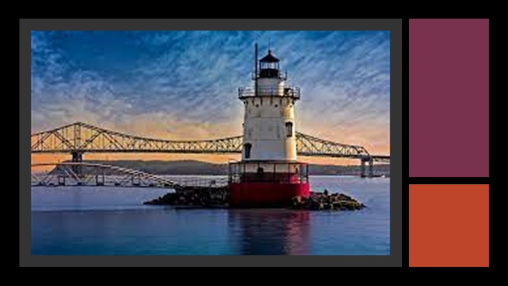
Next we come to the Sleepy Hollow Lighthouse in Sleepy Hollow, New York.

Today part of a county park, the Sleepy Hollow Lighthouse was said to have been built in 1883 to warn ships away from the shoals near the common route off Tarrytown and Ossining.

The tracks used by Metro-North’s Hudson Line, Amtrak’s Empire Service and CSX Freight are between the Sleepy Hollow Lighthouse and the developed sections of Tarrytown, New York, and the old cantilever Tappan-Zee Bridge, a mainline part of the New York State Thruway crossing the Hudson River at one of its widest points, is a 1-mile, or 1.6-kilometers, south of the lighthouse.
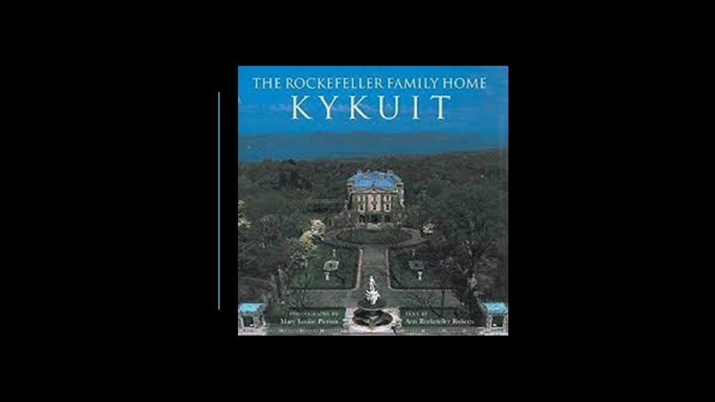
Interestingly, the John D. Rockefeller Estate known as Kykuit is near this location.
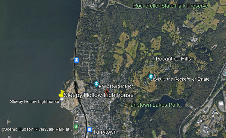
Situated on the highest point in neighboring Pocantino Hills, the Rockefeller Estate was said to have been built in 1913.
Sleepy Hollow.
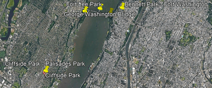
Further on down the Hudson River, there is a lot of activity on either side of the George Washington Bridge, connecting noteworthy locations in Manhattan and New Jersey.
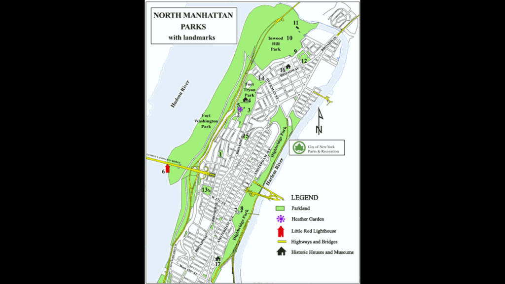
I am going to start unpacking what is here at Fort Washington Park on the Manhattan side of the George Washington Bridge.
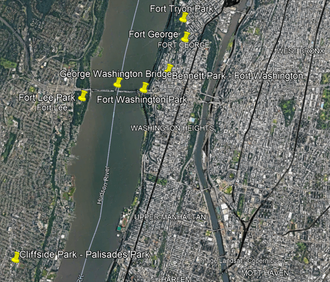
Fort Washington Park is a public park that is located along the river bank below the bridge, and part of the Manhattan Riverfront Greenway.
The West Side Line of Amtrak’s Empire Connection runs through the western part of the park…
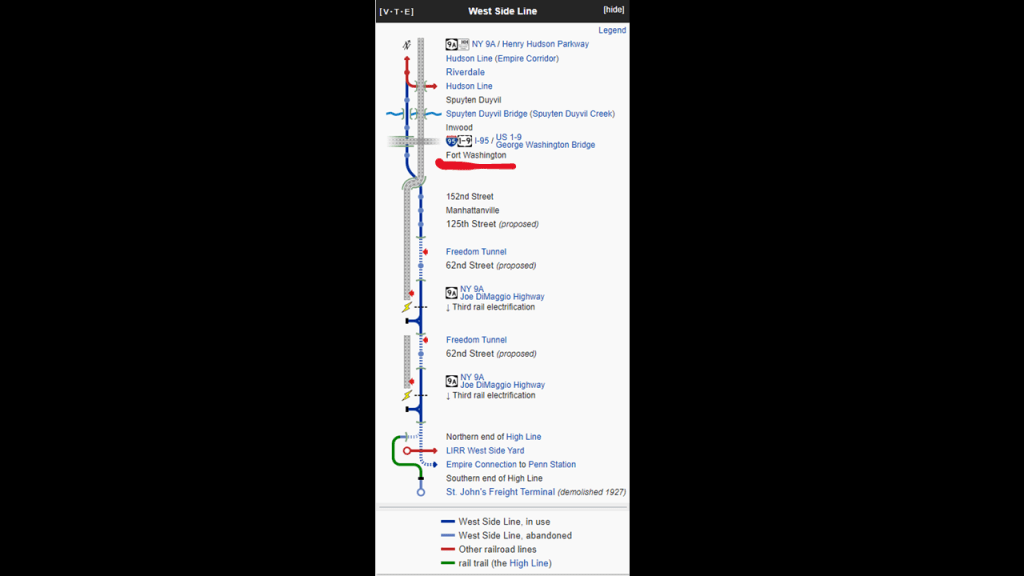
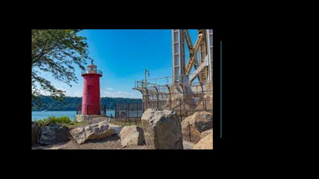
…and what is called the “Little Red Lighthouse,” officially Jeffrey’s Hook Light, is located right below the bridge.
It was said to have been constructed in 1921, decommissioned by the Coast Guard in 1948 with the completion of the George Washington Bridge making the navigational aid at this location obsolete.
Then in July of 1951, the Coast Guard signed the Little Red Lighthouse over to the city’s Department of Parks and Recreation.
Designated a New York City landmark in 1991, it was re-lighted by the city in 2002.
The remains of historic Fort Washington are in nearby Bennett Park, named for James Gordon Bennett, Sr, the newspaper publisher who launched the New York Herald in 1835.
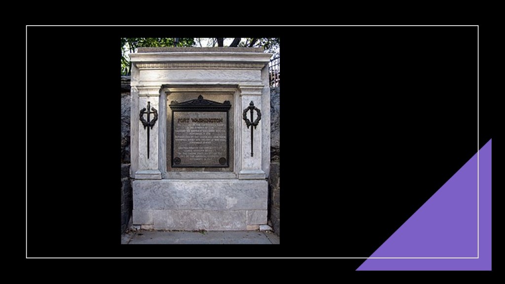
Fort Washington was called a fortified position at the island’s highest point near the north-end of Manhattan…

…and said to have been constructed to prevent the British from going upriver starting in June of 1776 by Pennsylvania battalions of the Continental Army for General George Washington.

Fort Lee, also known as Fort Constitution, was said to have been constructed starting in July of 1776 on top of a bluff on the Hudson Palisades directly across the river in New Jersey from where Fort Washington was concurrently being built on the other side.
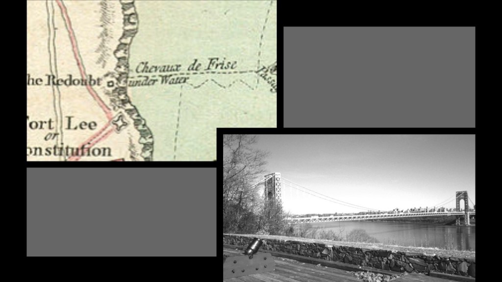
Alas, all of the hard work needed to build these fortifications came to nothing, since we are told that in November of 1776, in the Battle of Fort Washington, troops under the command of British General William Howe and Hessian General Wilhelm von Knyphausen made short work of the American forces stationed there, capturing both the forts, and taking a little over 2,800 American prisoners, of which only around 800 were said to have survived after being being kept in substandard conditions on-board British ships in New York Harbor.

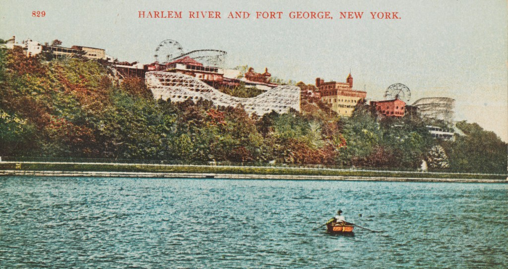
Now I am going to take a look at Fort George and Fort Tryon Park in this same neighborhood of Upper Manhattan called “Washington Heights.”
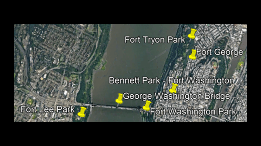
Fort George was said to have been built in 1776 on Fort George Hill near the intersection of Audubon Avenue and 192nd Street.
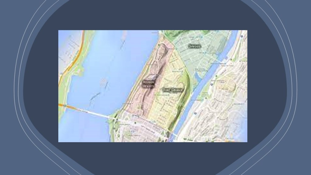
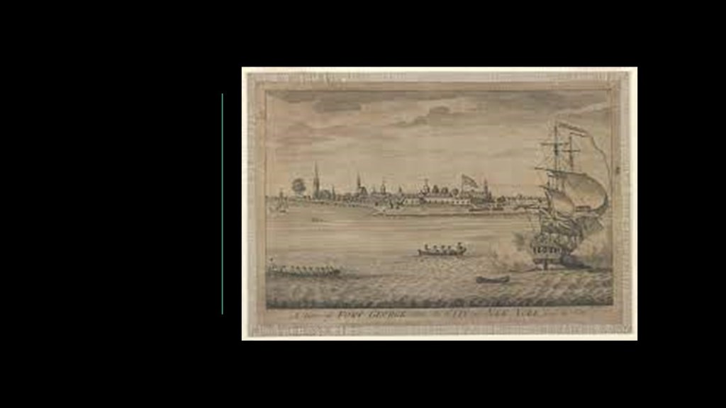
The historic Fort George Trolley Park operated here from 1895 to 1914.
Fort George was located at the end of the Third Avenue Trolley Line, and was said to have been developed as a Trolley Park starting in 1894 in order to give people a reason to use their trolley services at the end of their lines on the weekends and draw the residents of Manhattan to the riverside neighborhood for summer recreation.
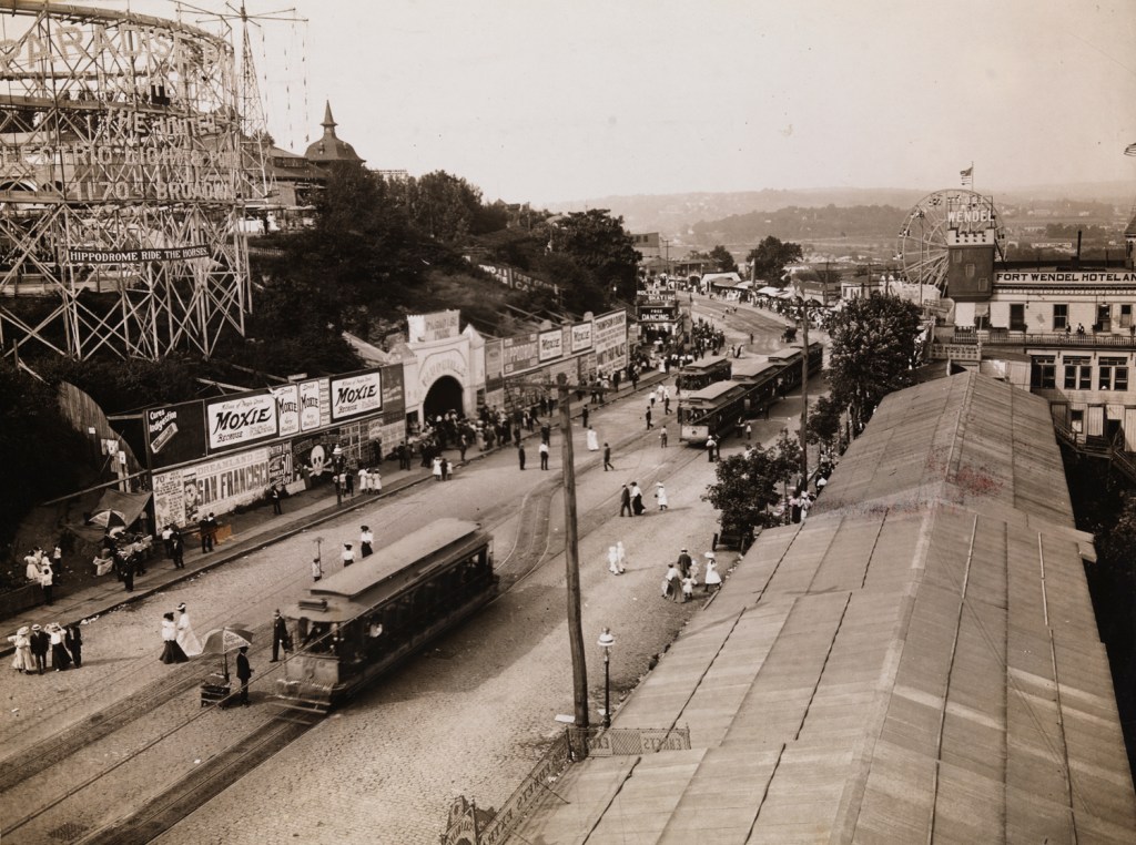
The park’s attractions included things like rides, saloons, casinos, the Harlem River Speedway, and vaudeville shows.
While the park prospered for years, but we are told that local residents began to petition for its closure in 1910 as benefits to the local economy faded, and the neighborhood suffered from social problems stemming from the park, like public drunkenness and high crime.
There was a suspicious fire on the property in 1911, but repairs were made and the park reopened.
Then in 1913, another suspicious fire that devastated the park, and after this one, the property was condemned and the land of the former trolley park was incorporated into Highbridge Park.
Fort Tryon was also located in the Washington Heights neighborhood of Upper Manhattan.
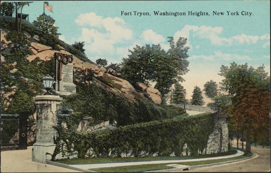
This is what we are told about Fort Tryon.
During the Revolutionary War, it was one of the sites of the Battle of Fort Washington mentioned previously, that resulted in a British victory and huge American loss.
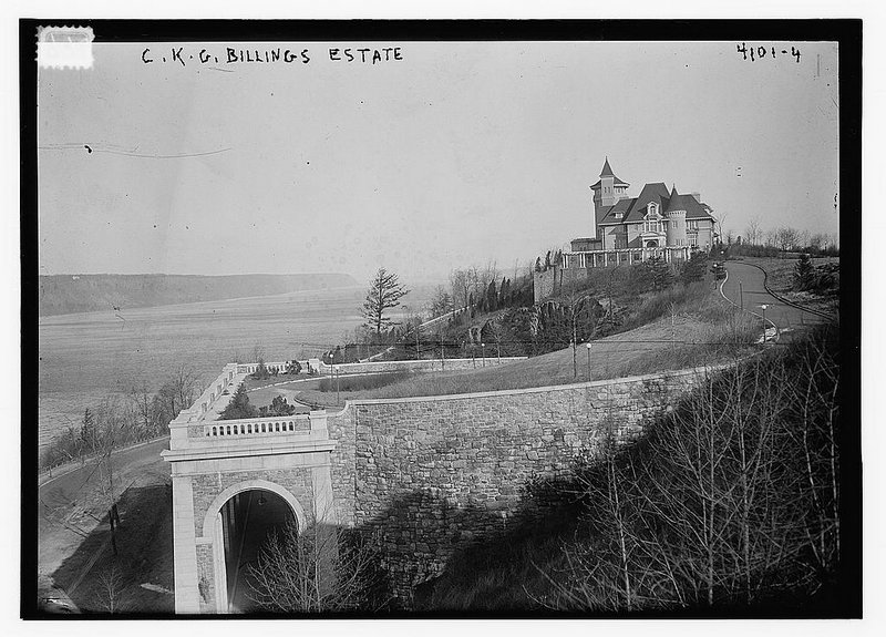
During the 19th-century, the area was said to be sparsely populated, but that by the turn-of-the century, Fort Tryon was the location of large Gilded Age country estates.
LIke the Billings Estate, the most luxurious of the estates.

We are told what became known as Fort Tryon Hall was built by wealthy Chicago businessman and horse-breeder Cornelius K. G. Billings, who hadpurchased 25-acres of land in what was called the “countryside” of northern Manhattan.
Billings, the former President of the People’s Gas Company of Chicago, was said to have started construction of his estate in 1901.
Billings’ estate had a mansion, stables for 60 horses, and an observatory.
By 1917, Billings was ready to move on, and sold his estate to John D. Rockefeller.
Rockefeller wanted to combine the property of this estate with two other estates and turn the land into a public park.
He wanted to tear down Fort Tryon Hall, but his architects protested so he changed course with other ideas for its use.
Well, I guess fate must have helped Rockefeller out because in 1926, a fire burned down Fort Tryon Hall along with its priceless works of art and other fineries.
We are told that remnants of Fort Tryon Hall include the driveway that Billings had constructed, a sort of bridge that extended over the edge of the hill with a “high, graceful arch at each end.”

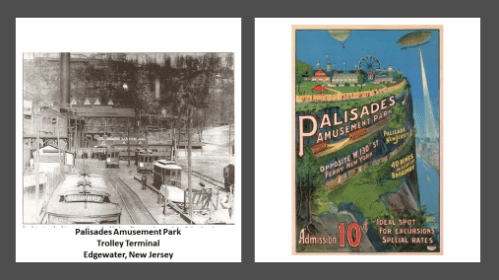
Palisades Amusement Park was across the Hudson River in Cliffside, New Jersey, adjacent to Fort Lee.
This trolley park was in operation from 1898 until its closure in 1971.
We are told that in 1898, the Bergen County Traction Company trolley operator originally conceived of the Park to attract evening and weekend riders for its service.
Over the years, and under different owners at different times, from the trolley park-era to the coming of cars and buses, the Palisades Amusement Park was one of the most visited in the country.
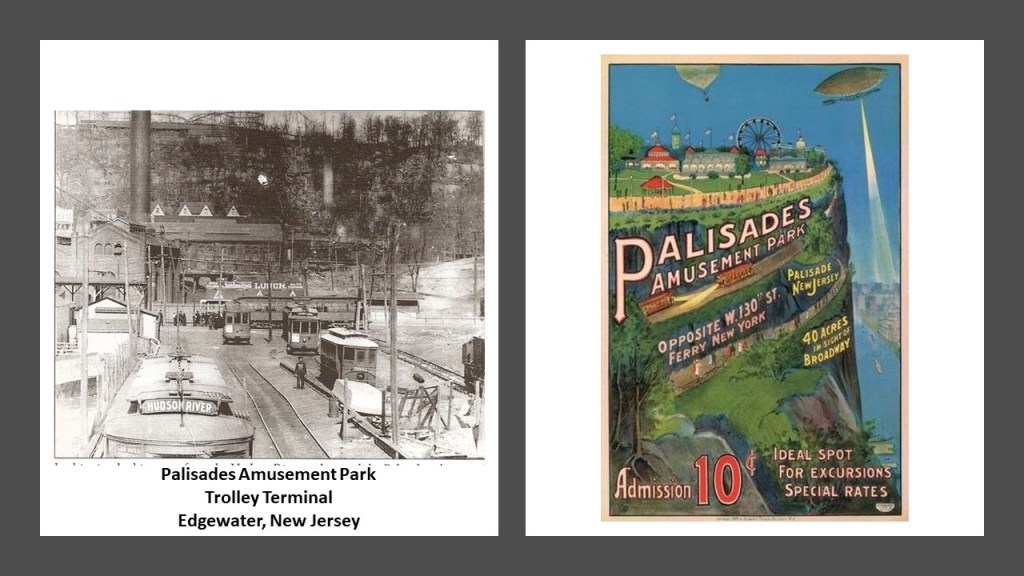
We are told that three main factors contributed to the park’s closure in 1971 – inadequate parking facilities; growing uncertainty about the park’s future; and an increase in the number of visitors who were injured or killed.
While four high-rise luxury apartments now stand where the amusement park was located, it is interesting to note there are still old stone ruins on the former park’s grounds.

Palisades Park was the first trolley park I ever stumbled across when I was doing research here in May of 2019 following cities and places in a circular alignment from Washington, DC, and where I first learned that trolley parks were said to have started out in the United States in the 19th-century as picnic and recreation areas at the ends, of street-car lines, and that by the 1920s, these trolley/amusement parks started to suffer a steep decline for a variety of reasons as we have seen.
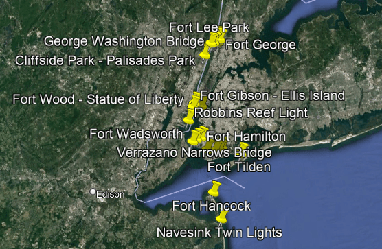
Going on down the Hudson River to where it joins with the Upper New York Bay, we come next to what were two pairs of star forts.
Upper New York Bay, also called the New York Harbor, is the traditional heart of the Port of New York and New Jersey.
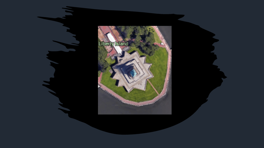
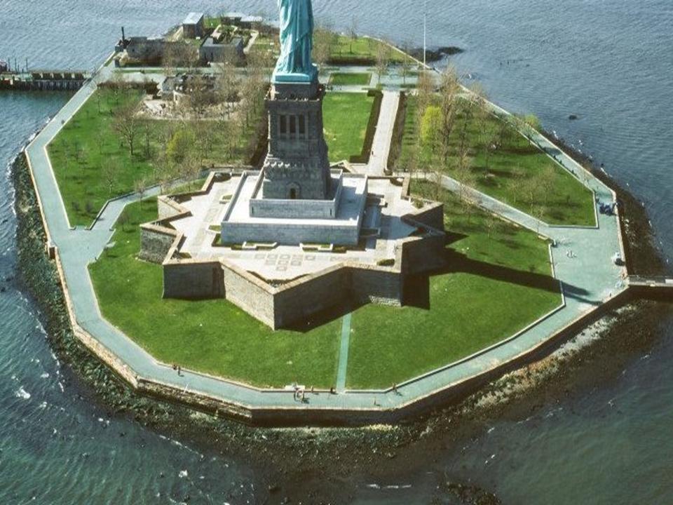
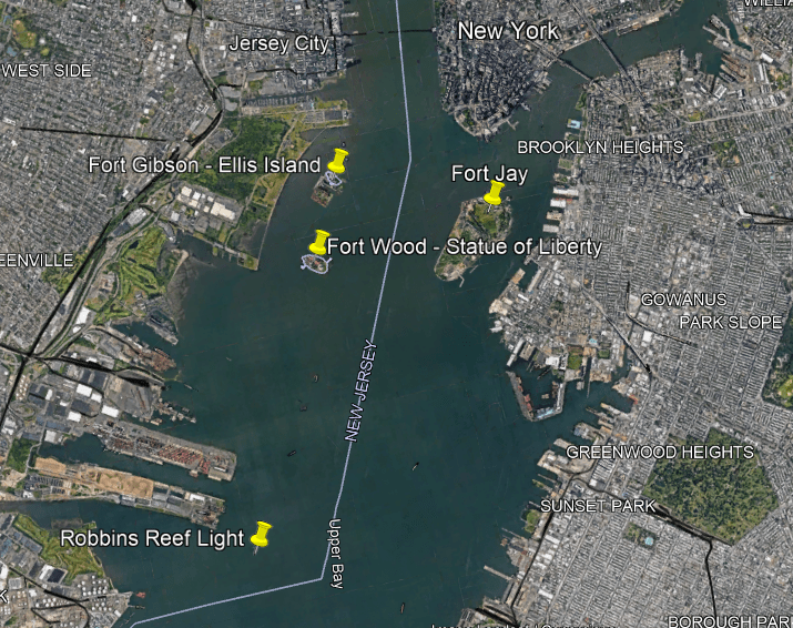
Liberty Island and Ellis Island are situated On the west side of Upper New York Bay near the Hudson River.

Liberty Island is described as an exclave of the New York City Borough of Manhattan, as it is in New Jersey waters. It was known as Bedloe’s Island until it was renamed Liberty Island by an Act of Congress in 1956.

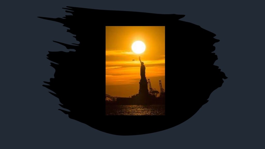
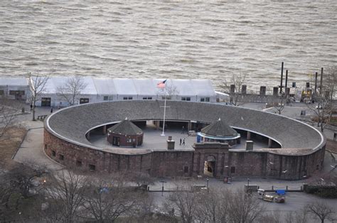
Fort Wood, the eleven-pointed star fort the Statue of Liberty sits on top of, was said to have been built between 1806 and 1811.
The Statue of Liberty itself was said to have been gifted by the people of France to the people of the United States, and dedicated on October 28th of 1886.
The Statue of Liberty also operated as a lighthouse between 1886 and 1901 when it was under the auspices of the United States Lighthouse Board, but was said to have been closed down because of operational costs.
It is interesting to note solar alignments with the torch, like this one that was photographed on January 14th of 2018, eleven days after the Earth’s perihelion, when the Earth and the sun are at their closest point all year.
And no where is it mentioned that Liberty Island is an artificial island…
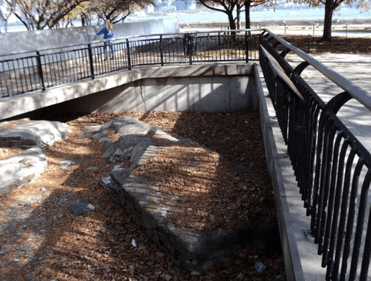
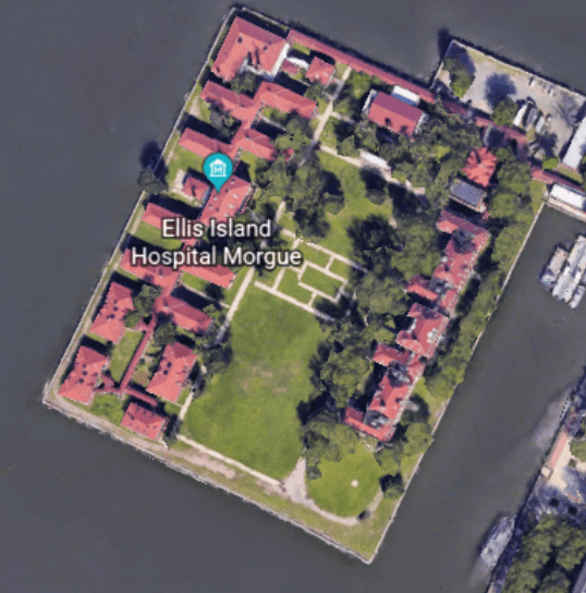
…and it is more obvious that Ellis Island located right next to it is an artificial island, with its geometric shapes, even though it is not called one either.
It was said to have been largely created through land reclamation.

Prior to when the current facilities are said to have been, Ellis Island was the location of Fort Gibson, one of forty forts said to have been built as part of the New York Harbor System between 1794 – 1812. This marker commemorates Fort Gibson…
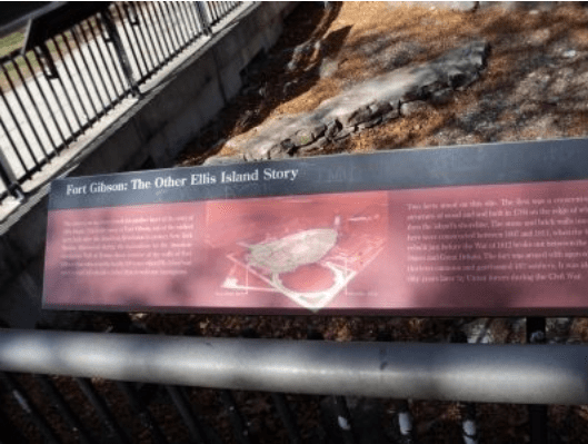
…on what became known as Ellis Island.
Co-Architects William Alciphron Boring and Edward Lippencott Tilton are given the credit for the architecture seen here today dating from the late 1800s to 1900, and which is currently the museum for Ellis Island.

It is said to be what is called Renaissance Revival architecture.
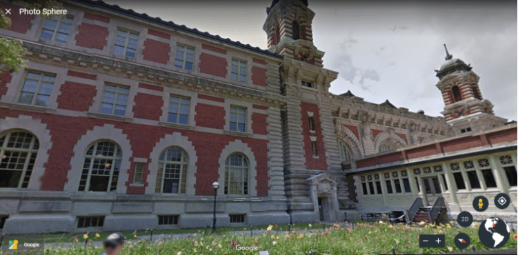
Ellis Island has been owned by the United States government since 1808, and has been operated by the National Park Service since 1965…The south-side of the island, which houses the Ellis Island Immigrant Hospital, has been closed to the public since 1954.
Governors Island is also in the Upper New York Bay, and situated at the confluence of the East River and the Hudson River…It is 800 yards, or 732 meters, from the southern tip of Manhattan Island, and separated from Brooklyn by the Buttermilk Channel by approximately 400 yards or 366 meters.

The first thing that caught my eye when I was looking at Governors Island on Google Earth was Fort Jay, named after Supreme Court Chief Justice & Founding Father John Jay, and part of the Governors Island National Monument…

…said to have been built in 1794 to defend Upper New York Bay, and an active installation until 1997.
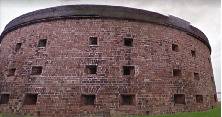
Another feature of the Governors Island National Monument is Castle Williams, part of the New York Harbor System defenses. It is called a circular structure of red sandstone, having been built between 1807 and 1811 under the direction of Lt. Colonel Jonathan Williams of the U. S. Army Corps of Engineers.
Battery Park, at the southern tip of Manhattan, the historical location of another star fort, Fort Amsterdam, said to have been surrendered by the Dutch to the British in 1664…

…and Castle Clinton, a circular fort said to have been built of red sandstone between 1808 and 1811, and the first immigration center of the United States before Ellis Island, between 1855 and 1890.
Castle Clinton was also known as the “West Battery,” a complement to Castle Williams as the “East Battery” on Governors Island. More on the use of the word battery shortly.
We come to the Robbins Reef Lighthouse in Upper New York Bay on the way to the Narrows, on the west side of the main channel, in a straight-line alignment with the Statue of Liberty and Ellis Island.
It was said to have been originally constructed of granite, and replaced by a cast-iron station in 1883.

The Upper New York Bay is connected to the Lower New York Bay by the Narrows, described as the tidal strait separating the Boroughs of Staten Island and Brooklyn, and forms the principal channel by which the Hudson River empties into the Atlantic Ocean.

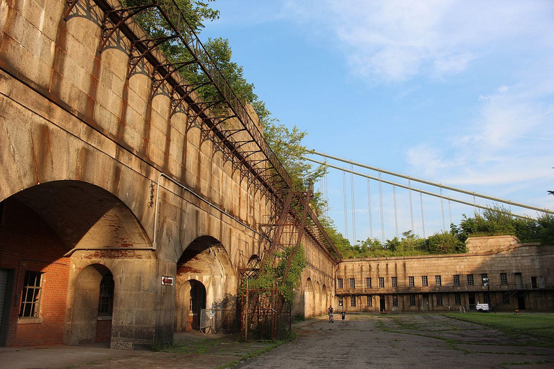
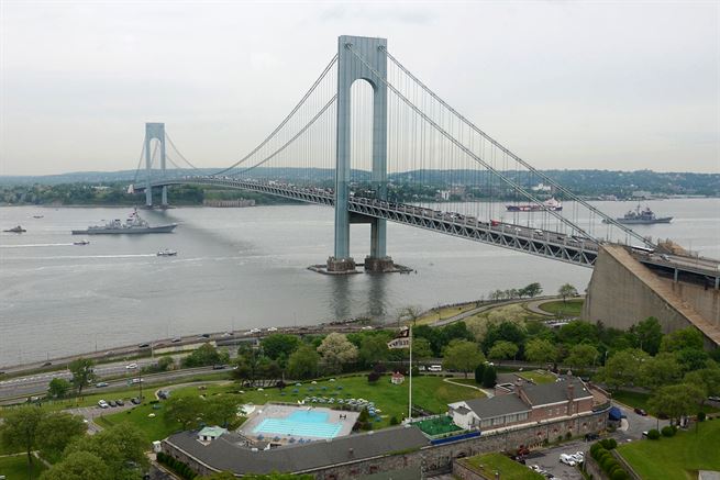
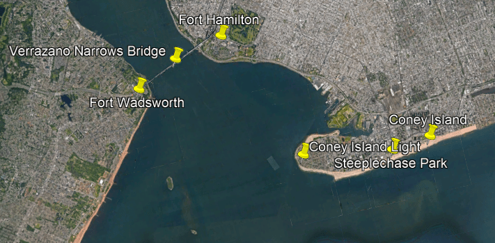
The Verrazano Narrows Bridge connects the New York City Boroughs of Staten Island and Brooklyn.
Fort Wadsworth is directly beside the northern-side of the bridge on Staten Island.

It is described as a former United States Military Installation said to have been established before the War of 1812, as well as between 1845- 1861, and a natural defense point for the Upper Bay of Manhattan and beyond.
I could not find clear reference dates on its construction.
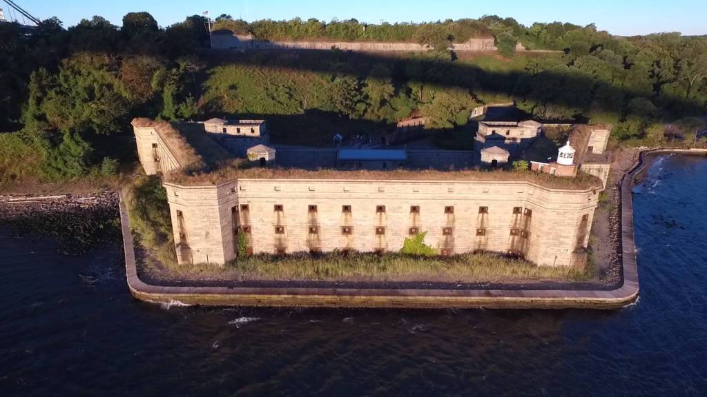
This sturdy structure was closed in 1994, and is now also administered by the National Park Service’s Gateway National Recreation Area.
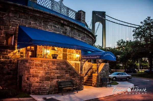
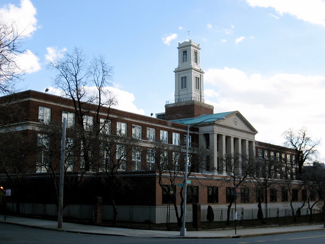
On the southern side of the other end of the Verrazzano-Narrows Bridge is Fort Hamilton in Brooklyn.
Fort Hamilton is an active United States Army installation.
This is the Fort Hamilton Community Club…
…the high school for the community of Fort Hamilton…
…and Fort Hamilton community real estate for sale.

Coney Island is just a little ways to the southeast of The Narrows.
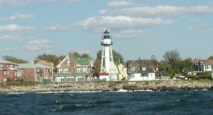
The Coney Island Lighthouse is situated on the western end of Coney Island, in Seagate, east of the Ambrose Channel of New York Harbor, in what appears to be a triangulated relationship with Fort Wadsworth and Fort Hamilton on either side of the Verrazano-Narrows Bridge.
The Coney Island Light was said to have been built in 1890.
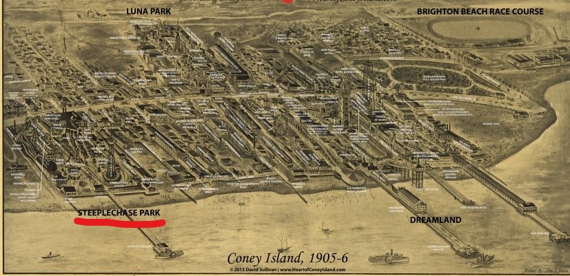
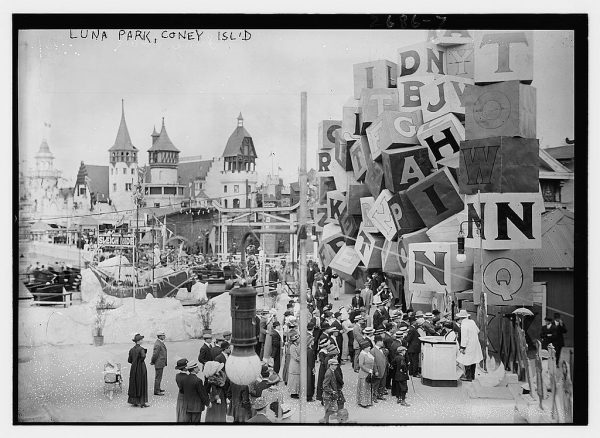
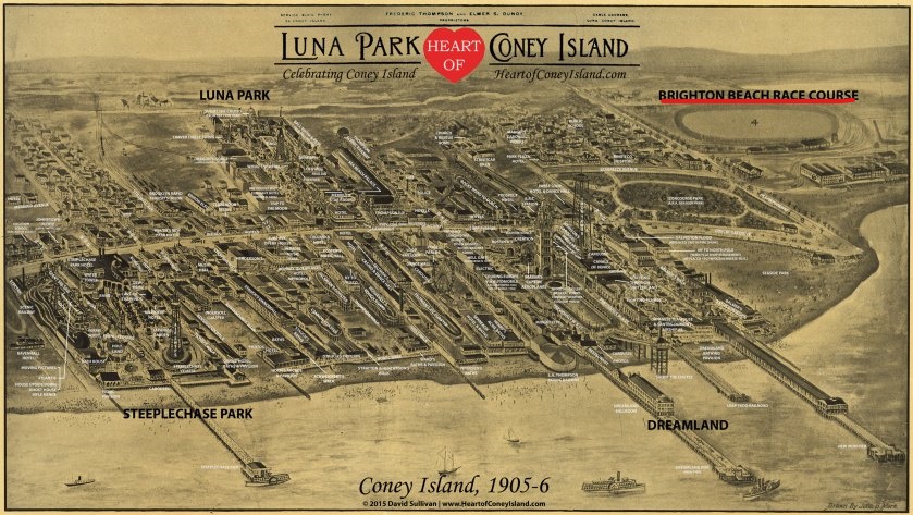
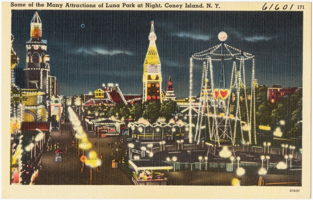
There were three historic amusement parks on Coney Island in Brooklyn- Steeplechase Park, Luna Park and Dreamland.
This is what we are told about them.
Steeplechase Park was created by entrepreneur George Tilyou in 1897.
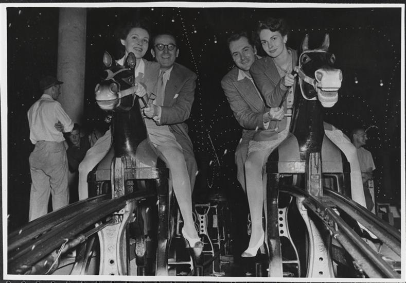
He bought and improved the Steeplechase Horses attraction, which featured mechanical horses pulled along metal tracks.
The owner George Tilyou adopted a “Funny Face” mascot depicting a smiling man with several dozen teeth, nicknamed “the Tilly,” as the icon for his park.

The entrance to Steeplechase Park had a grand archway, the top of which was decorated with four horses.

The park included over 50 attractions on its midway alone…
…and Tilyou was said to have been inspired to build a Ferris Wheel after having seen the one at the 1893 Chicago World’s Fair on his honeymoon.
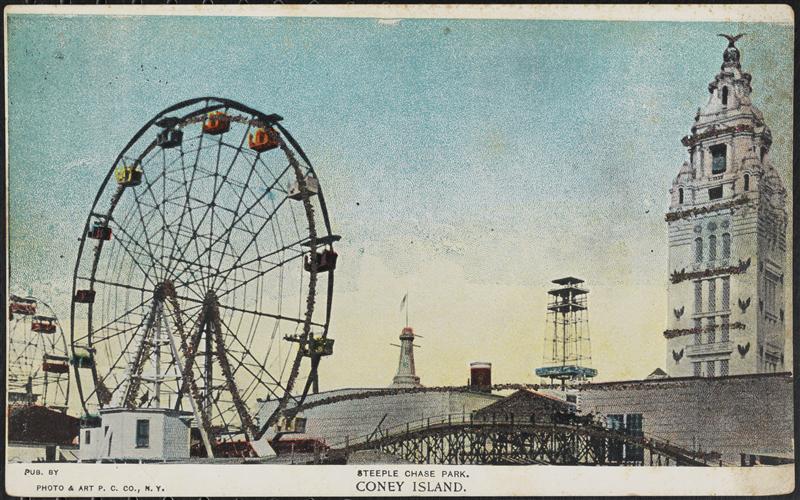
In Steeplechase Park’s history between its opening in 1897 and closing in 1964, there were things like fires, rebuilding, rides added, and so on.
The land of the former amusement park today is Maimonades Park, the location of a minor league baseball stadium…

…and the only remaining structure from Steeplechase Park is the defunct Parachute Jump.

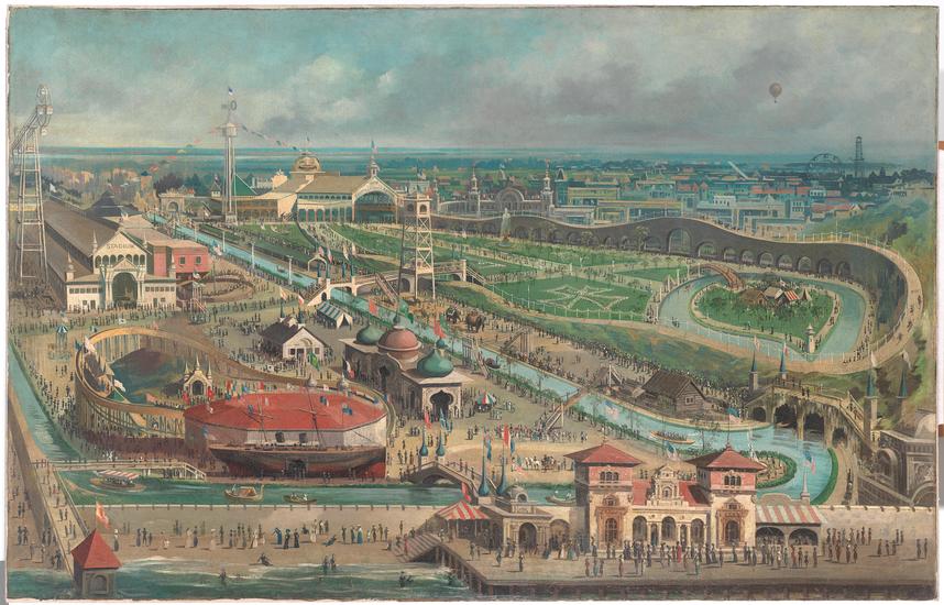
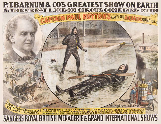
Luna Park at Coney Island opened in 1903.

It was said to have replaced Sea Lion Park that was operated by a man named Paul Boyton between 1895 and 1902, the first enclosed and permanent amusement park in North America.
He was credited with being the first person to pay an admission fee to a large enclosed area containing multiple amusement rides and activities.
The so-named Captain Paul Boyton was a world-famous back in the day aquatic daredevil and showman who travelled the world’s rivers in an inflatable rubber suit.
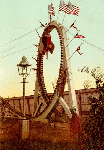
The Flip Flap Railroad mentioned at the bottom of this image of Sea Lion Park…
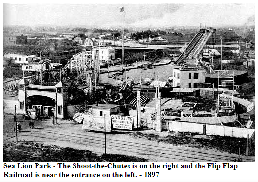
…was said to be the first looping roller coaster.
Paul Boyton’s remaining long-term lease on the park was bought ou starting on October 1st of 1902 by Frederic Thompson and Elmer “Skip” Dundy.
Thompson and Dundy were invited to the Steeplechase Park by George Tilyou for the 1902 Season.
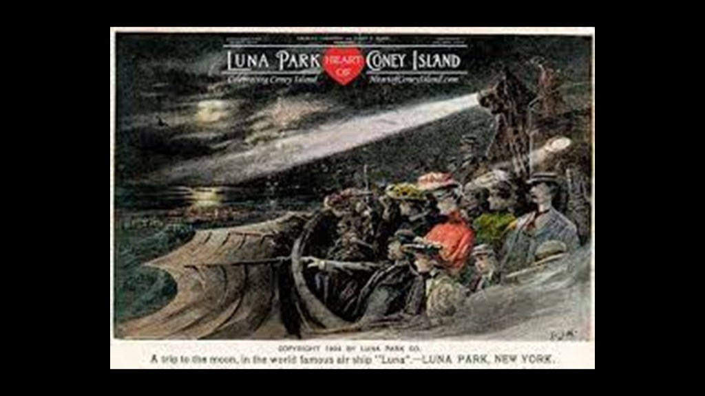
They were known for their ride called “A Trip to the Moon” that was at the 1901 Pan-American Exposition that was held in Buffalo, New York.

The name of the fanciful airship that was the main part of the “A Trip to the Moon” ride was “Luna,” the Latin word for “moon’ for which, we are told, Luna Park in Coney Island was built around.
Well, for one thing, the problem with that story is that there were, and still are, Luna Amusement Parks all over the world, including Mashhad, Iran, and Ankara, Turkey.

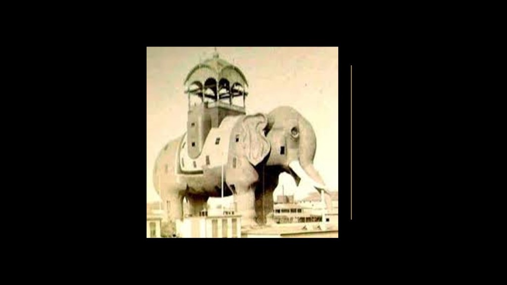
The land Luna Park was on was located next to where the Elephantine Colossus Hotel had been located.
We are told this hotel was a tourist attraction on Coney Island that was an example of novelty architecture, designed by Irish-American inventor James V. Lafferty.
The massive elephantine structure stood above Surf Avenue and West 12th Street from 1885 to 1896, at which time it burned down, giving Thompson and Dundy more land upon which to build Luna Park.
Speaking of elephants, this picture was taken in January of 1903, when Luna Park was said to have been under construction.
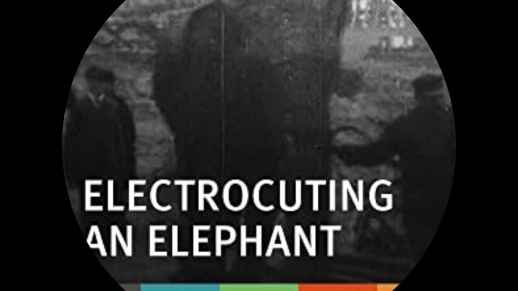
It shows Topsy the Elephant before she was executed by electrocution for being a “bad” elephant by Thompson and Dundy as a publicity stunt to advertise the opening of their new park.
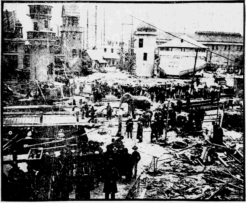
The invited press that day included the Edison Movie Manufacturing Company, who filmed the event.
It was released to be viewed in coin-operated kinetoscopes under the title of “Electrocuting an Elephant.”
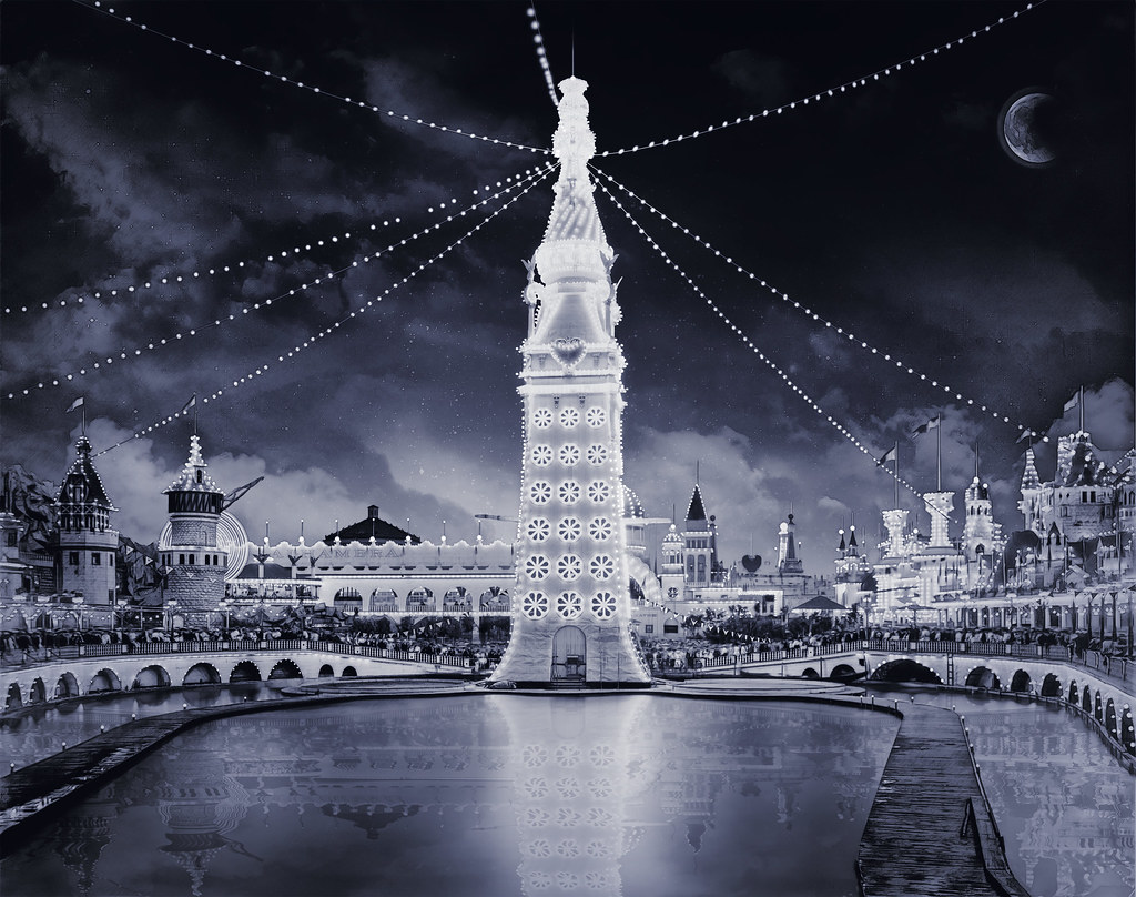
We are told the park’s architectural style was an oriental theme, with over 1,000 red and white painted spires, minarets, and domes on buildings constructed on a grand scale.
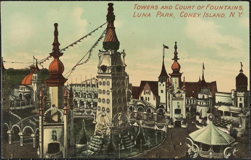
All the domes, spires, and towers were lit-up at night with several 100,000 incandescent lights.

In the middle of the lake at the center of the park was a 200-foot, or 61-meter, tall Electric Tower that was decorated with 20,000 incandescent lamps, said to be a smaller version of the Electric Tower featured in the 1901 Pan American Exposition in Buffalo.
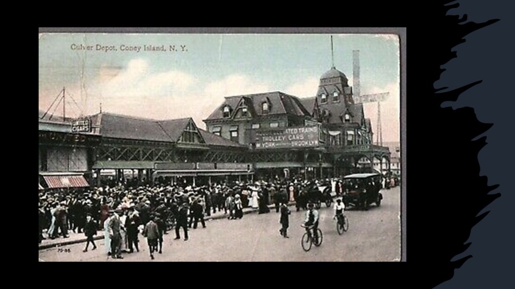
Luna Park was accessible from Culver Depot, the terminals of the West End and Sea Beach Streetcar and Railroad lines.
Besides a multitude of rides, attractions at Luna Park included infant incubators, described as a new type of infant care where infant incubators containing premature babies were displayed in shows called “Infantoriums.
They were touted as “neonatal healthcare,” helping newborn babies with compromised immune systems by providing a sanitary environment to reduce the possibility of getting an infection.
infant incubators for premature babies became widely available at fairs and amusement parks across America, rather than hospitals, which we are told, had nothing to help them.
What we are told is that many parents of premature, at-risk babies pretty much had to bring their infants to a side-show infantorium at an amusement park or fair, and that these infant shows were the main source of healthcare for premature babies for over forty years.
Say what??!!
Over the years, Luna Park would continue under different management, with constant changes.
The end of Luna Park came with two fires in 1944, one in August and one in October, which destroyed the park, and in 1946, the whole park was demolished.
There has been a Luna Park operating near the original location since 2010 that has no connection to the 1903 park.

Compare Luna Park at Coney Island with the White City in London, the location of numerous international expositions between 1908 and 1914, after which time it fell into a state of disuse and disrepair and demolished for a housing estate in 1937.
And why does the architectural-style at both places look Moorish?
Well, how about because the worldwide civilization was Moorish!

The Advanced Civilization from the ancient time of Mu to relatively recently?
And then something happened to knock Humanity off that positive timeline!
Dreamland was the third and last of the three original parks said to have been built on Coney Island in the early 19th-century.

Dreamland was said to have been founded by successful Brooklyn real estate developer and former State Senator William H. Reynolds as a refined and elegant competitor to the chaotic noise of Luna Park, and opened in May of 1904.
The location of Dreamland was near the West Eighth Street subway station opposite Culver Depot.

Everything at Dreamland was touted to be bigger than Luna Park, including the larger Electric Tower, and four times as many incandescent lights than Luna Park.

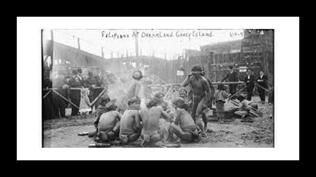
Besides having high-class entertainment, morality plays, and rides, Dreamland had human zoos featuring dwarf inhabitants in what was called “Midget City…”

…and a Somali Village…

…and a Filipino Village.
Like Luna Park, Dreamland also had an infant incubator sideshow attraction.

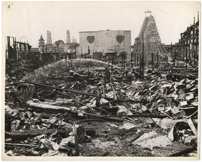
Dreamland’s life on Coney Island was ended only 7-years after opening.
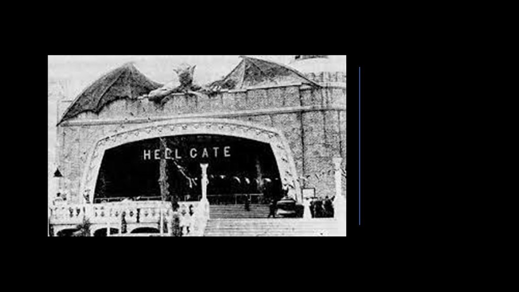
On May 27th of 1911, a fire started at the Hell Gate attraction the night before the season’s opening day, and spread quickly, completely destroying the park by morning.
There are a couple of more things I would like to bring up before I leave this part of New York City.
One is Brighton Beach, which is adjacent to the three major Coney Island amusement park locations.
The Brighton Beach Race Course was an American thoroughbred horseracing facility shown here opened on June 28th of 1879.
It was instantly successful and drew wealthy patrons from New York City.
The track prospered in 1908, when the New York State Legislature passed the Hart-Agnew Law, banning gambling.
The Brighton Beach Race Track was eventually torn down, and by the 1920s, replaced by residential housing.

Back around 2015, about three-years before I started blogging and doing my own research in 2018, I remember seeing a video on the New Earth YouTube Channel about megalithic remains strewn about on Brighton Beach, so I searched for images like this one of Brighton Beach…

…and the explanation we are given for faces amongst the rocks was that there was a mystery artist in the 1970s who carved them.

The last thing I want to point out is the absolutely ruined-looking appearance found in the landscape here.
Jamaica Bay is coalled a partially man-made and partially natural estuary on the western tip of Long Island, and contains numerous marshy islands.
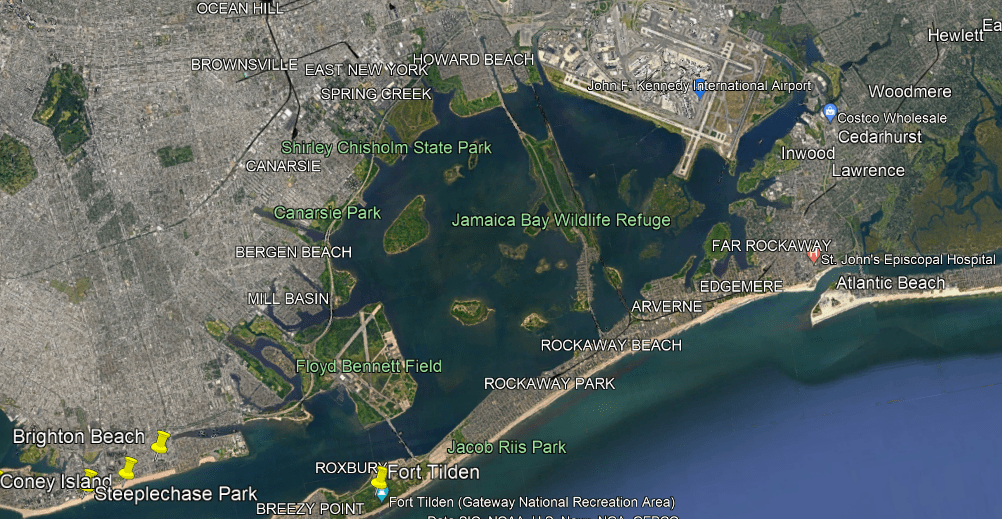
John F. Kennedy International Airport is on the northeast side of Jamaica Bay, and would have been in short-distance, straight-line alignment with the former Brighton Beach Race Course.
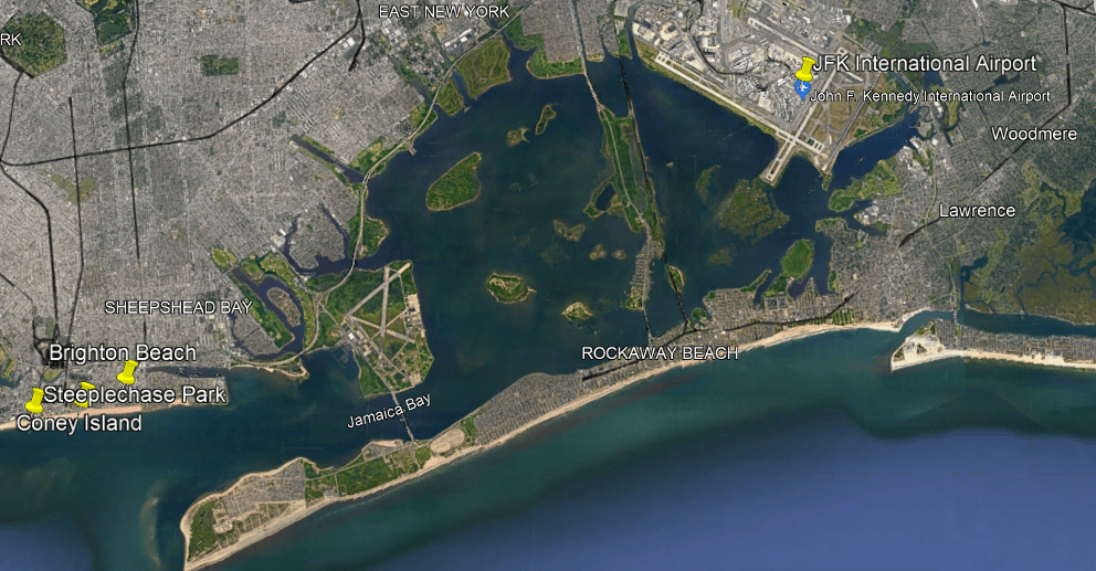
Interestingly, there is a rapid transit line of the New York subway system that operates here, the IND Rockaway Line that runs between the Aqueduct Racetrack Station terminal, also close to the airport in a short-distance, straight-line alignment, and the Rockaway Park-Beach 116th Street Station terminal.

The long and narrow Great South Bay is east of Jamaica Bay on Long Island’s south shore.
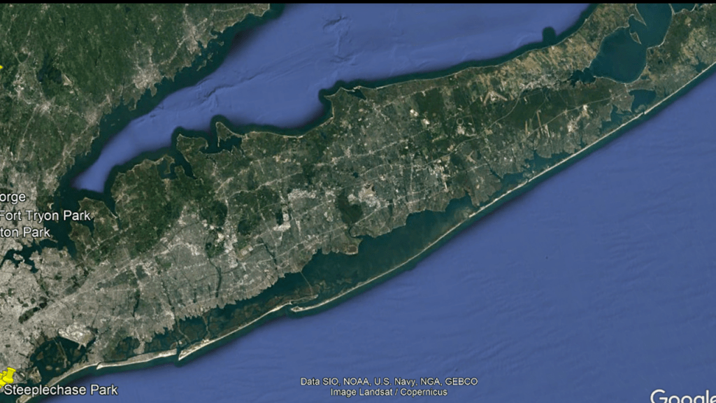
The Great South Bay is described as a lagoon that is 45-miles, or 72-kilometers-, long, and has an average depth of a little over 4-feet, or 1.2-meters, and is 20-feet, or 6-meters, at its deepest.

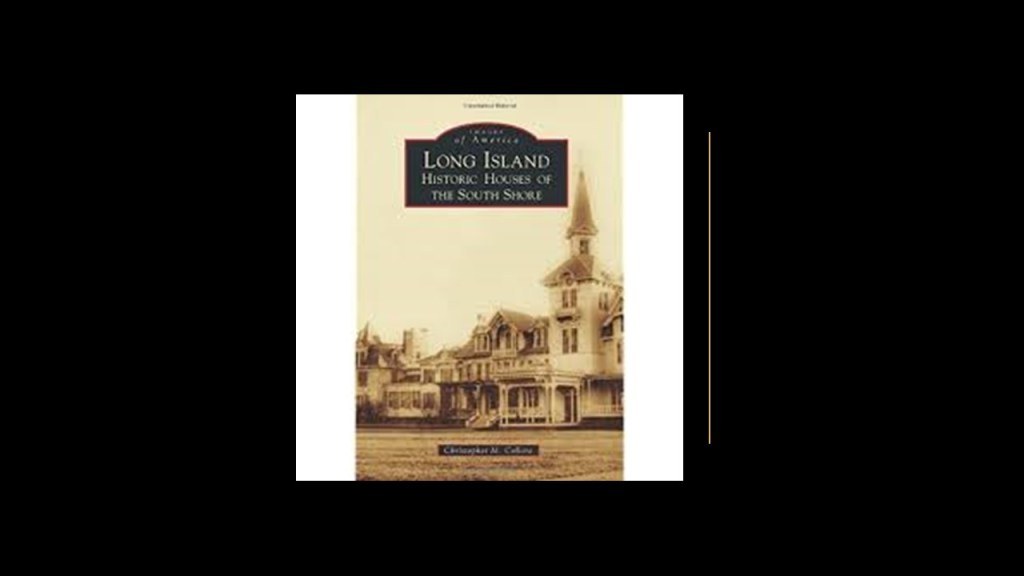
I am sure there is a lot more to find here, but I will share this book cover and say that during the so-called Gilded Age, the Vanderbilts, Roosevelts, Whitneys, Morgans, and Woolworths were said to have built country estates on the North Shore of Long Island, and summer mansions on the South Shore.
Next, a look at lighthouses in the Lower New York Bay.

The Great Beds Lighthouse is just offshore from the northwestern New Jersey coast, located at the Great Beds Shoal near the mouth of the Raritan River.
It was said to have been built in 1880, and manned until 1945.
The Old Orchard Lighthouse is said to have been built in 1883, and is three-miles south of the center of Staten Island.
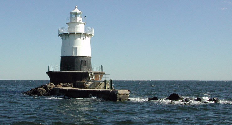
This is the West Bank Lighthouse, which serves as the front-range light for the Ambrose Channel, which is used in navigation to indicate safe passage, or position fixing. It was said to have been built in 1901.

The Staten Island Lighthouse is on Richmond Hill is the rear-range light for the Ambrose Channel, a 90-ft-high, or 27-meter, tower said to have been built in 1912, and is 141-feet, or 43-meters, above sea-level.

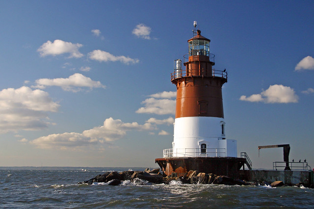
The Romer Shoal Lighthouse is situated between the ship channels of Ambrose, Swash, and Sandy Hook, and is approximately 3-miles, or 5- kilometers, north of the Sandy Hook Lighthouse. It was badly damaged by Hurricane Sandy in 2012. It was said to have been built in 1838.
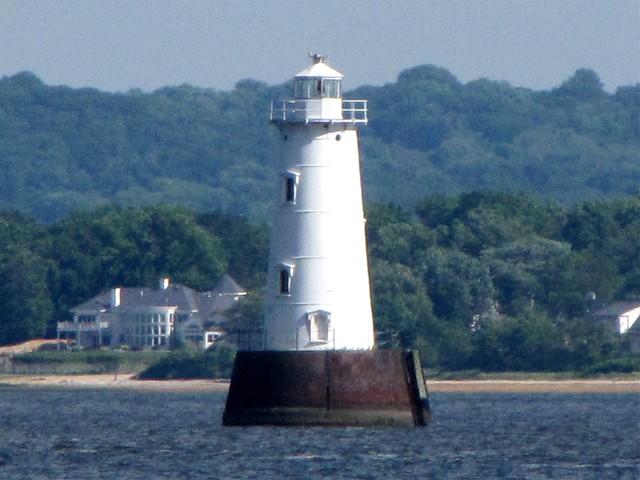
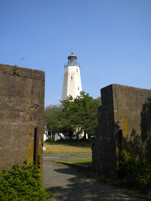
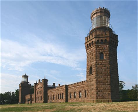
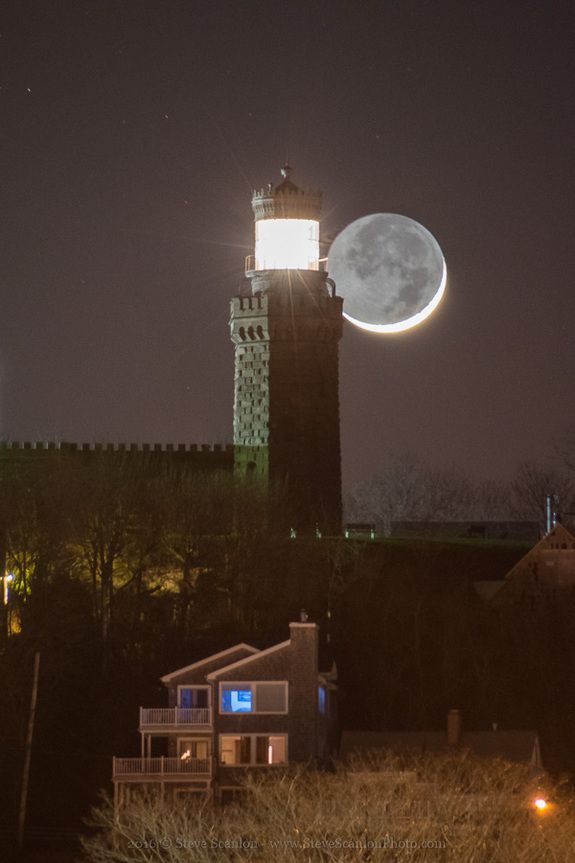
Fort Hancock, and the Sandy Hook Lighthouse, are located at the northern end of Sandy Hook at the entrance of the Atlantic Ocean.
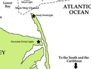
The lighthouse on Sandy Hook at Fort Hancock is said to be the oldest working lighthouse in the United States, and we are told it was built in 1764.
The construction of Fort Hancock was said to have started in 1857 and ended in 1867, without completing the building of the fort under the supervision of then-Captain Robert E. Lee of the Corps of Engineers, and was designed as a five-bastion irregular pentagon, built primarily of granite.
Not only was the fort said not to have been completed, it was also said to have had most of its surviving parts taken down by the U. S. Army after World War II.
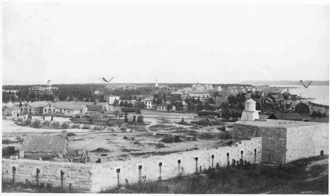
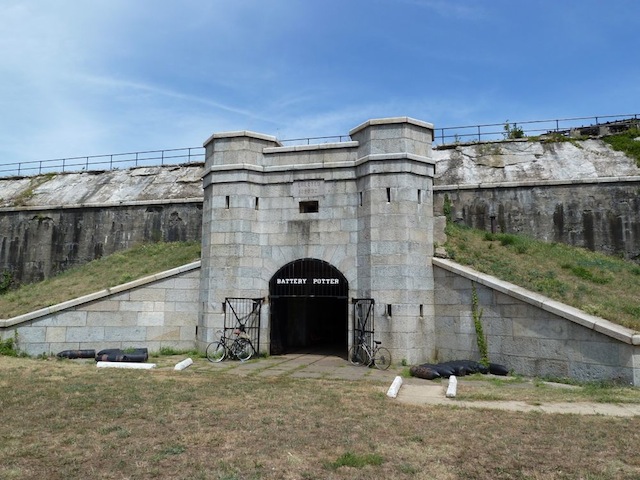
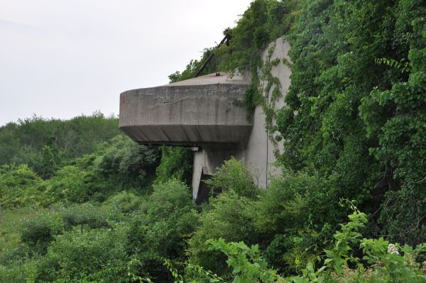
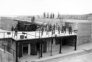
The batteries of the now designated Fort Hancock were said to have been constructed starting in 1890 as part of the Sandy Hook Proving Ground for the testing of coastal defensive weapons, like Battery Potter.
Battery Potter is described as the prototype for a steam-hydraulic, gun-lift carriages, otherwise known as “disappearing guns.”
Fort Hancock is said to have become inactive in 1974, and is now part of the National Parks of New York Harbor, and the Gateway Recreation Area, under the National Park System.

Just north of Sandy Hook is the Ambrose Channel, the main shipping channel in and out of the Port of New York and New Jersey.
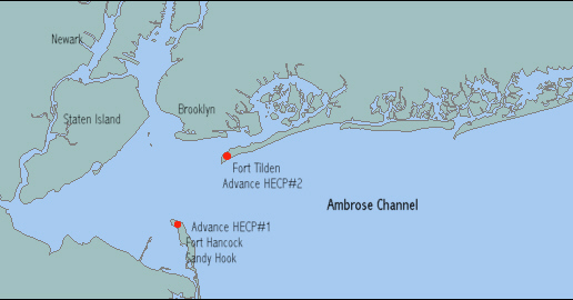
On the other side of the Ambrose Channel from Fort Hancock on Sandy Hook is Fort Tilden on the Rockaway Peninsula in New York, a now abandoned Army installation that was said to have been built in 1917, and in use until 1995. It is now part of the Gateway National Recreation Area, and administered by the National Park Service, like Fort Hancock.
The Navesink Twin Lights are on the headlands of the Navesink Highlands, overlooking Sandy Hook Bay.
Navesink was also the name of the Lenni Lenape people who inhabited the Raritan Bayshore near Sandy Hook, and Mount Mitchill in the scenic highlands in eastern New Jersey.
We are told, however, that the Twin LIghts were built in 1862.
The American Civil War is said to have taken place between 1861 to 1865, so we are expected to believe this solid masonry structure apparently with a lunar alignment was built during war-time.
This is one of the places on the Earth where it is exceedingly clear that something is really wrong with the narrative, with many great examples of the flimsy cover stories we are told about how infrastructure came into, and in so many cases, left existence.
Early wars in North America where massive masonry forts like the Crown Point State Historic Site in northern New York, said to have been built quickly during the French and Indian War time-frame in the mid-1700s, and then either destroyed or abandoned during or after those wars…

…Trolley Amusement Parks that were terminals of trolley car lines that went up in flames or are otherwise long-gone, like Luna Park at Coney Island…

…and lighthouses that were said to have been built in the 19th- and 20th-century for the sole purpose of navigational aid and then by-and-large deactivated and turned into local attractions.
There were many lighthouses here historically that are no longer physically present.
Between the entrance to the lower New York Bay at the Atlantic Ocean to the locations around the George Washington Bridge across the Hudson River, I have specifically looked at eleven star forts that are in pairs and/or clusters; five major historic trolley amusement parks; and eleven lighthouses.
First, star forts, which quite frequently have the word “battery” associated with them, like the “Battery Pottery” at Fort Hancock that I just talked about.
What are the meanings of “battery?”
One is “a device that produces electricity; may have several primary or secondary cells arranged in parallel or series.”
Another is “the heavy fire of artillery to saturate an area rather than hit a specific target.”
Or ” An assault in which the assailant makes physical contact.”
I think the answer to the mystery of star forts, found in pairs and clusters here in New York and all over the Earth, lies in the first answer – that somehow these star forts functioned as batteries or circuitry for the purpose of producing energy for the earth’s grid system, but they were re-purposed to the second definition in another time-line to have a military function.
Does the third definition of battery apply here?
I think that it does, in the sense that a major assault has been committed against Humanity by all that has taken place here without our knowledge and consent, and removing all of this critical information from our awareness about the True History of Humanity, and so, so much more.

Next, Trolley Amusement Parks.
The word terminal is associated with rail-lines, defined as “The end of a railroad or other transport route, or a station at such a point” and “A point of connection for closing an electric circuit.”
Trolley amusement parks were typically located at the end of streetcar lines, like what we saw back at the famed Palisades Park near Fort Lee in New Jersey.
Was there some kind of enhanced energy-generation going on with trolleys and amusement parks on the earth’s free-energy-generating system?
It sure looks to me like the Electric Amusement Parks found at the terminals, or ends, of trolley lines were a really fun and beautiful way the designers of the original advanced civilization contributed to powering the earth’s free-energy producing grid system.
This thought leads me to the last subject I have studied in-depth in this post – lighthouses.
While I do believe that lighthouses likely served to guide ships through maritime passages, I also think they were serving multiple purposes on the earth’s grid system,.
Perhaps “lighthouses” were literally “as “a house for light” for the purposes of precisely distributing the energy generated by this gigantic integrated system that existed all over the Earth that was in perfect alignment with everything on Earth and in heaven.
The parasitic and multi-dimensionally aware beings behind the wholesale destruction of Earth’s True History and Humanity’s Legacy want us to believe that suffering, sickness, misery, destruction, death was and is our normal state of being, and not question what we have been taught about who we are.
They are the only ones who benefit because they energetically feed on Humanity’s negative emotional states.
What was Team Dark to do?
They were jealous of Humanity…greedy…and hungry for power.
They wanted to rule over it all, take the wealth for themselves, and control the destiny of Humanity for their own benefit.

But the problem is in a Free Will Zone like Earth, the Human Beings who live here have to give their consent to choose whether the follow the Light or the Dark.

The only way they can accomplish this acceptance, however, is by outright lies, deception and duplicity because if people knew the true agenda of these controllers, the majority of Humanity would never, ever accept this.
I believe that these beings with a negative agenda devised a complicated plan to knock Humanity off the original positive timeline of Higher Consciousness…

…in an interdimensional war in order to control Humanity, using Humans as their pawns against the Creator and Creation.

I, for one, do not believe they are going to get away with what they have done, and that we are in the midst of the Great Awakening that Team Dark has done everything imaginable, and unimaginable, to prevent.


2 thoughts on “Star Forts, Gone-Bye Trolley Parks and Lighthouses of New York’s Hudson River Valley & New York Bays”