
Considering that water covers approximately 70% of the Earth’s surface, I found a surprising number of individual small islands, or island groups/chains, that are prominent on the grid lines emanating off of the North American Star Tetrahedron.
I found them connecting cities and places around a globe that are aligned in circles and lines over long distances. And I had never heard of most of them. This is actually a very big subject, so I will more than likely bring a substantial amount of information into form in more than one post. There are a lot of islands to cover, and tie-ins to what has been happening on the planet for some time. I will be re-visiting the subject in-depth in a future post called “History Reads Like a Book on Planetary Gridlines.” Some of that topic most definitely will come up in this post as well.
I will show you exactly what I discovered about the planet’s obscure islands in these posts.
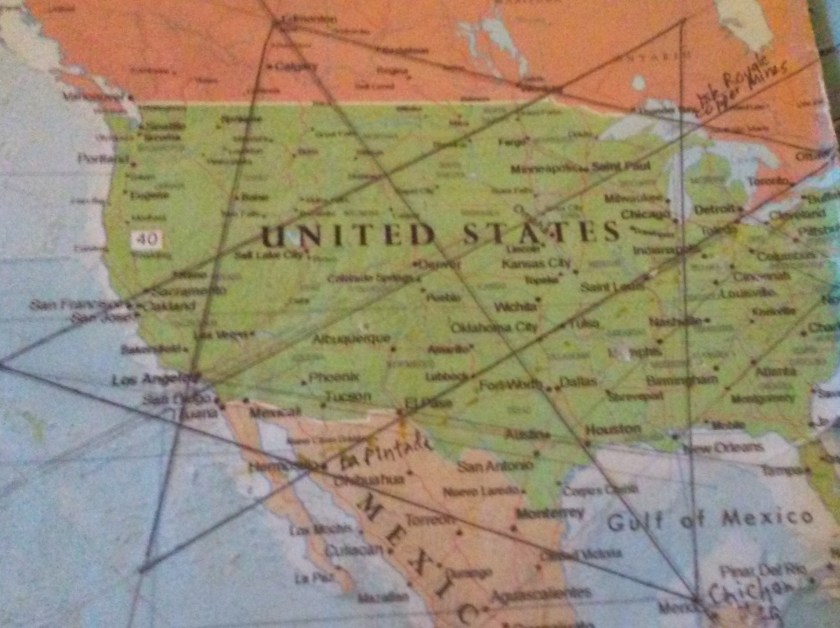
A gridline on the Star Tetrahedron emanating from Merida, Mexico – which is the location of Chichen Itza – passes directly through better-known islands such as Grand Cayman Island (claimed by the UK, and off-shore banking haven); Kingston, Jamaica; and Grenada (U.S. Invasion 1984).
On its way around the globe, this same alignment also passes directly over some less well-known islands.
Fernando de Noronha, which is claimed by Brazil, is an archipelago of 21 islands, with only one of the islands being inhabited. Please note the solar alignment between the two off-shore peaks showing this photograph. This is a hallmark of the Ancient civilization, which was always aligning heaven and earth in every possible way.

The only land between Fernando de Noronha and Sesfontein, Namibia is Ascension Island, a speck in the Atlantic Ocean over which the alignment directly passes.


What is interesting about Ascension Island, besides the name? Well, for one thing, it is a British colonial outpost. There is an U.S. military airbase, satellite and submarine tracking stations, a BBC transmitter, and a listening post run by GCHQ’s Composite Signals Organization. They have been squeezing the residents out for over 100 years.
Moving on to the Pacific Ocean on the other side of the alignment through Africa, the alignment passes over the southern tip of Madagascar at Cape Sainte Marie. Keep in mind, with what I am saying about the True Children of Israel, that in my video I said there has been a re-emergence of Judaism in Madagascar, which they say was the original faith of the island. Catholicism arrived in 1841. The island was colonized by the French in 1896. It regained independence in 1960.

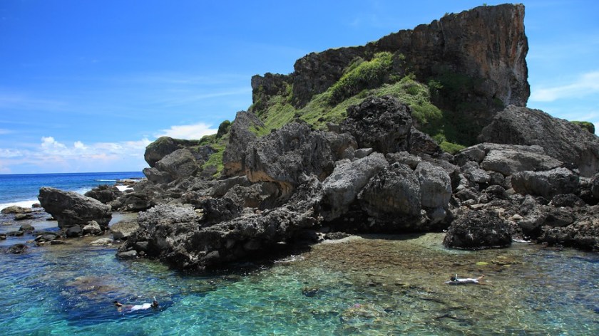
From there, the alignment proceeds to cross over the French Sub-Antarctic Islands of St. Paul, and Amsterdam, and they are among the most isolated places on earth.
St. Paul (Ile de St. Paul), of which I included a picture of in the video for its shaped shoreline, as you can see in the foreground in the photo on the left, there are block-shaped rocks – another characteristic of the Ancient Civilization. Now, the only human presence is temporary on occasion as there is a scientific research cabin located there. France claimed the island in 1843.


The other island is Amsterdam Island, and is 53 miles from St. Paul. It also has a seasonal scientific presence.


Moving along the alignment, you come to Macquarie Island, upon which the Australian Government has a base for the Australian Antarctic Division, which includes 20 – 40 scientists, and a weather station and heliport
Macquarie is also designated as a UNESCO World Heritage site as the only place in the Pacific Ocean where rocks from the mantle are actively exposed at sea level. Let’s see what that looks like, shall we?

Well, well, well… What do you think? Actively exposed rocks from the earth’s exposed at sea level…or pyramids? This is how they hide it. Before the internet, who would even know?
After this particular alignment goes through Borobodur, one of the nodal points of the consciousness grid located in Yogyakarta, Indonesia, it continues on over Banjarmasi and Balikpapan, Indonesia.

Then it goes through Davao in the Phillippines, until it comes to the Northern Marianas and the Mariana Islands – Ascuncion, Pagan, Tinian, Saipan, and Guam. The Northern Marianas are a self-governing Commonwealth in association with the U. S. and Guam in the Marianas is a Territory of the U.S.
This whole area, including Balikpapan in Indonesia (there was a battle there in 1945) , was part of the Southwest and South Pacific Theater. Now that I think of it, Theater is a funny word choice for an area or place in which important military events occur or are progressing. A theater can include the entirety of the air space, land and sea area that is or that may potentially become involved in war operations. Hmmm. There are no coincidences. The dark forces have to tell us what they are doing so it can be our free will choice to be controlled, but they do it in a very twisted and devious manner where no one knows they are being told. Not Legit, and We Do Not Consent!!!!
Here is a photo of Midway Island, site of a major World War II Battle:
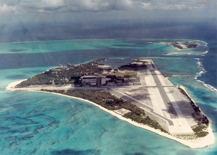
That’s Midway, Folks!
And the U. S. Government still has a claim there as well. Midway is an unorganized, unincorporated Territory of the United States, and continues to be the only island in the Hawaiian Island chain that is not part of the state of Hawaii.
Makes me wonder what World War II was really about….
I think I am going to stop here. What I have shared here is one alignment only, and I have much more on other alignments. I will share this information in a series of posts.

Michelle, you have expanded my mind in so many ways. What a treasure your information is!! Thank you for sharing all of what you have found and doing so in such an interesting and informative way.
I really appreciate the information and keep up the wonderful work you are doing!!!
LikeLike
I just found you from The Higherside Chats. The amout of amazing information here is overwhelming and SO impressive!
I heard you say and see here on your site that you love strangers suggestions. At a glance I cant see you already have written about this, but I’ve only just arrived…so I just thought I’d mention: years ago I had heard Barbara Bush was Aleister Crowley’s illegitimate child. Her mother was with him in France (if memory serves) and she left for the US once she realized she was pregnant. As I say, this was years go, and I can’t find it now online, but back then, there was a side by side of the two faces, and that was what sold it. Somerhing you said with Greg on the podcast made me wonder if you’d heard that before.
Best wishes…off to look around here ♡
LikeLike
This is so amazing, so much information and documentation about the Tartarian/Moors’ electric grid, this is heaven for me.
I moved into Ireland 11 years ago, and happen to live 5 minutes from a beautiful Star Fort’s entry (Cork’s Elisabeth Fort). I violently woke up a little while ago and have been looking into the Tartarian/Moors story ever since. I read some books, but nothing as amazingly profound detailed and documented as your research around the world. Thank you Michelle, diving into the whole thing straight away. 🙏
LikeLike