
I am going to be taking a close look in this video at North Africa, starting with the city of Sousse on the Tunisian coast where a long-distance alignment enters the African continent from Valletta in Malta in the Mediterranean Sea, and I look at places on and near where the alignment makes its way across the Sahara Desert in North Africa to Mauretania on the western coast of Africa, and follow it to where the alignment crosses the Cape Verde Islands in the Central Atlantic Ocean.

Most of the research in this post came from a 23-part series called “Sacred Geometry, Ley Lines & Places in Alignment” that I did back in 2020 tracking a long-distance alignment of cities and places that started in San Francisco.

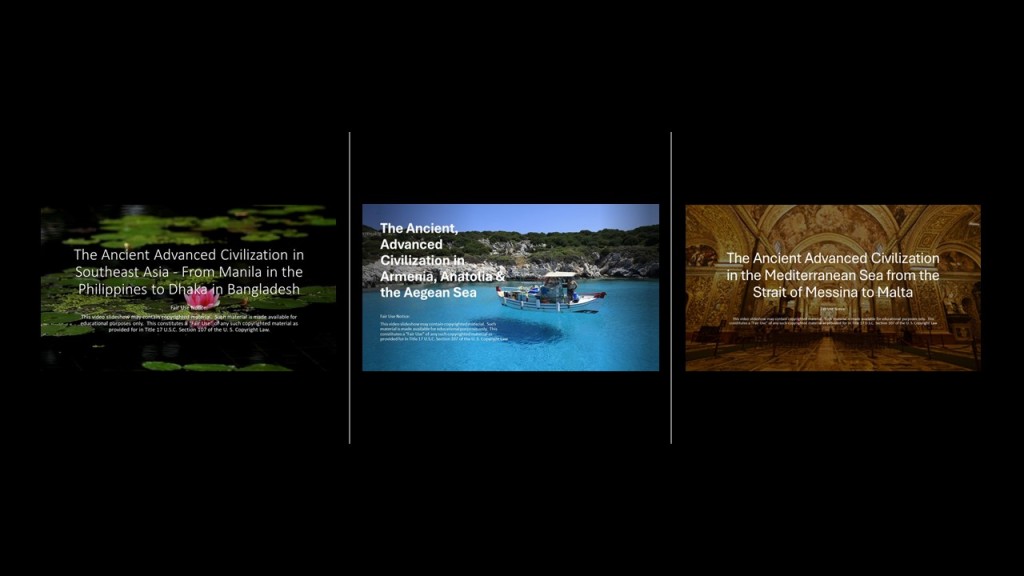
So far from the original 2020 series, I have posted ” The Ancient Advanced Civilization in Southeast Asia – From Manila in the Philippines to Dhaka in Bangladesh;” “The Ancient Advanced Civilization in Armenia, Anatolia & the Aegean Sea;” and “The Ancient Advanced Civilization in the Mediterranean Sea from the Strait of Messina to Malta.”
From the process of tracking cities and places in several different alignments over the years, I have collected a variety of puzzle pieces about different places.
These pieces of the puzzle bring a bigger picture into focus that is not immediately apparent on the surface from this type of geographically-focused research.
In the last post, I took a tour of the amazing city of Valletta, and capital of the island Republic of Malta. I looked around what is found in the Marsamxett Harbor; around the Grand Harbor; and within the city walls of Valletta.
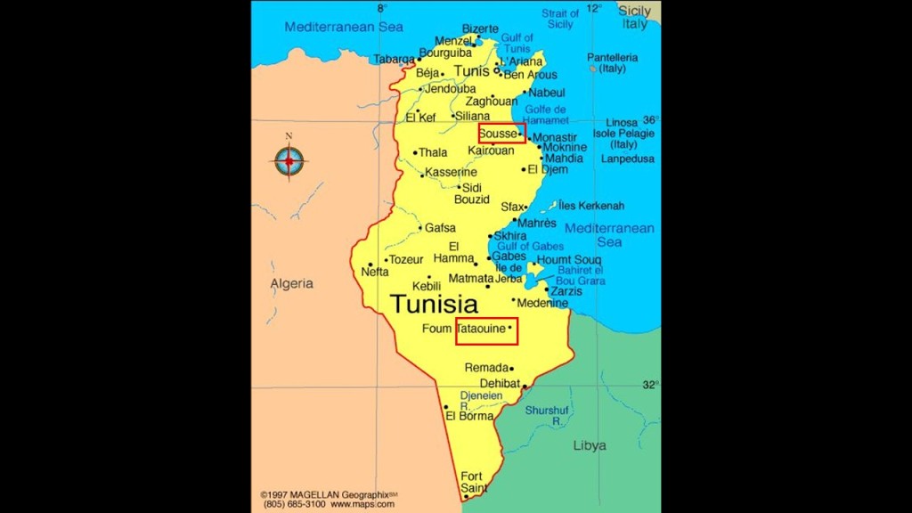
I am picking up the alignment in Sousse, the capital of Tunisia’s Sousse Governorate, one of the 24 governorates of Tunisia, and located 87-miles, or 140-kilometers, south of the nation’s capital of Tunis.

Sousse is considered one of the most beautiful cities in Tunisia, and is located on the Gulf of Hammamet.
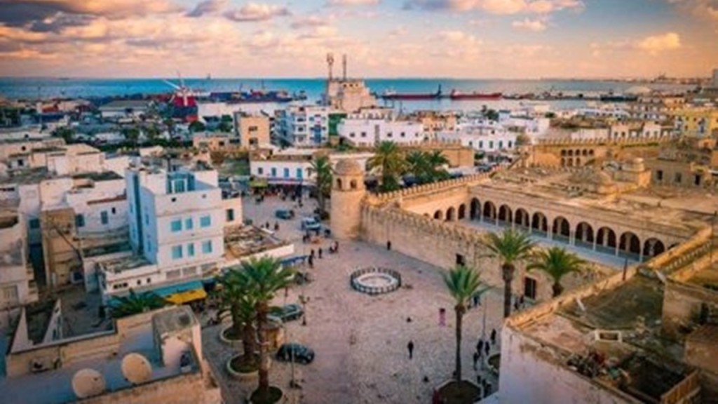
Sousse is a transportation hub.
It is a port city…

…where there are two lighthouses at opposite ends of the harbor entrance…

…just like at the harbor in Valletta, Malta…

…and at the Port of Dover, England, in the English Channel.

Sousse is linked by the widest road in the country, the A-1 Motorway, a 153-mile, or 247-kilometer, highway that connects Tunis with Sfax, another port city in southern Tunisia, and conceived of as part of an international project called the Trans-Maghreb Highway.

The Maghreb is another name for northwest Africa, a region which we are told was referred to in English and European sources, in the 16th- through 19th-centuries, as the Barbary Coast.

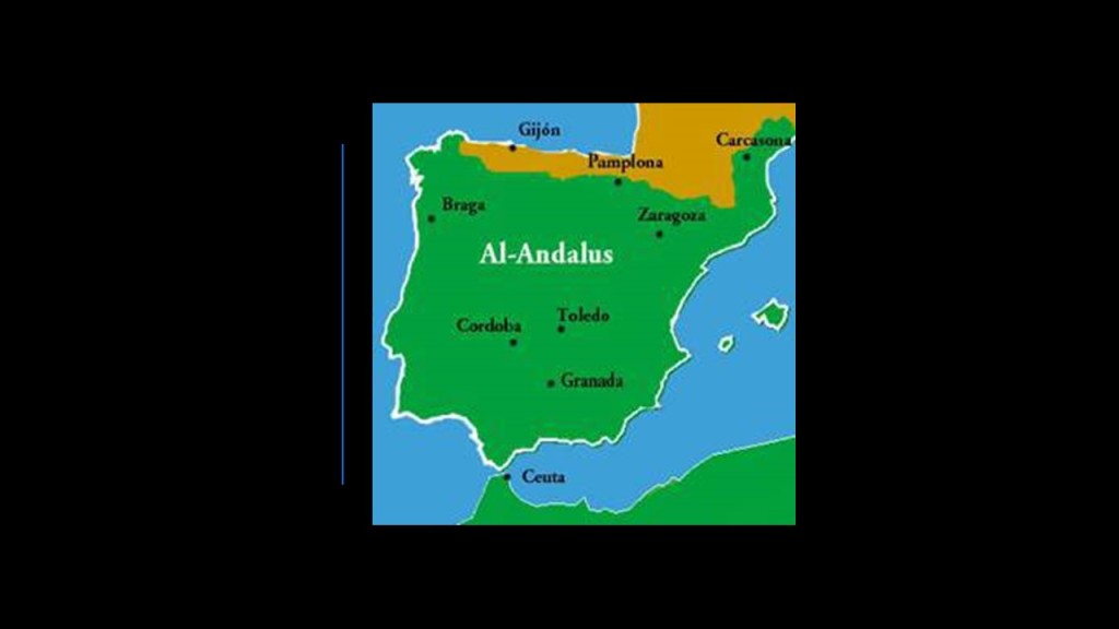
What we are also told about the Maghreb is that during the era of al-Andalus in Moorish Spain between 711 AD and 1492 AD, the Maghreb’s inhabitants, Muslim Berbers or Maghrebi, were known by the European’s as “Moors”…and that’s about as much as they will give up to us directly about this particular subject.
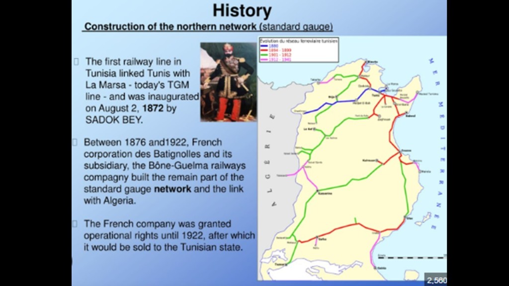
Sousse is also connected by railway to Tunis.

What we are told is that the construction of the railway in Tunisia first began around 1872 under the ruler at the time, Bey Muhammad III as-Sadiq , to serve the capital city of Tunis, and then extended to Algeria; to Sousse; and to places like Sfax on the coast which phosphate port, and Haidra near the border with Algeria, where there was lead, phosphate and ore mining.
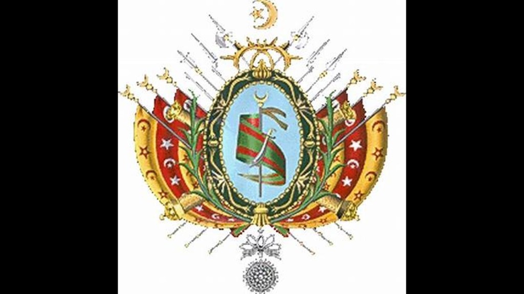
In taking a look at the history of Tunisia, I found that at the beginning of the 1800s, Tunisia was described as a quasi-autonomous province of the Ottoman Empire.

At this time in its history, we are told that its trade increased dramatically with Europe in the 1800s, with the arrival of western merchants wanting to establish business in the country.
Then, the Bey of Tunis from 1855 to 1859, Muhammad, was forced by the British and French to sign the 1857 Fundamental Pact, which increased freedoms for non-Tunisians.
Here’s another clue we are talking about Moors.
Bey is one of the five noble titles of the Moors, the other four being – Dey, El, Al, and Ali.
Also in the Ottoman Empire, Bey was the title of the governor of a province.

Then, we are told, in 1861, Tunisia enacted the first constitution in what was called the Arab world, but a move toward a modernizing republic was said to have been hampered by a poor economy and political unrest.
We are starting to see the use of the word “Arab” replacing that of “Moor.”
Contained within the 1861 Constitution of Tunisia, we find that it was also the first state to establish Islam as its religion.

The world would be in a much better place if we were talking about Moorish Islam, which is about reconnecting with our higher selves and raising our level of consciousness into Higher Consciousness.
I – Self- Law – Am – Master.
I think this marked the beginning of turning the original Islam into the mechanism for creating a new form of fundamentalist Islam, where it was conceptually altered in order to lead us to what we see now as radical Islam, and its destructive role in today’s world.

Regardless of the new Constitution, when the Tunisian government couldn’t manage the loans made by foreigners to the government, it declared bankruptcy in 1869.
Then Britain and France cooperated between 1871 and 1878 to prevent Italy from acquiring Tunisia as a colony having investment, and subsequently Britain supported the French interest in Tunisia in exchange for dominion over Cyprus.
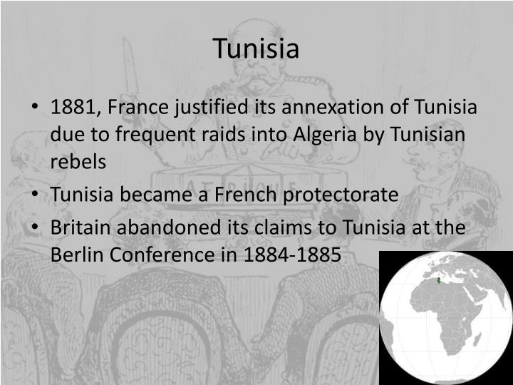
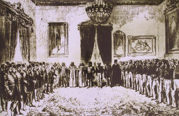
Using the pretext of a Tunisian invasion into Algeria, the French invaded Tunisia in 1881 with an army of 36,000, which quickly advanced to Tunis, entering by way of places like Sousse on the coast…

…and subsequently occupying Tunis.

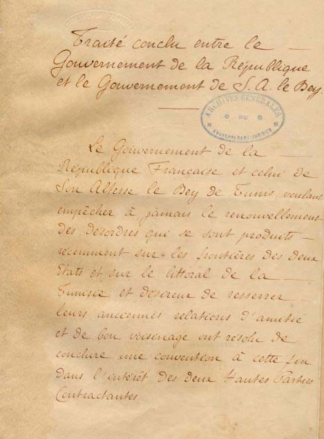
Then, the French forced the new Bey, Muhammad III as-Sadiq, to make terms in the form of the 1881 Treaty of Bardo, which gave France control of Tunisian governance and making it a de facto French Protectorate.
The French progressively assumed more of the important administrative positions, and by 1884 they supervised all Tunisian government bureaus dealing with finance, post, education, telegraph, public works, and agriculture.

French settlements were encouraged, with the number of French settlers said to have grown from 34,000 in 1906, to 144,000 in 1945, and the French administration weakened the local tribes in rural areas.
This was said to depict an urban map of Tunis between 1890 and 1914.

Then, on March 20th, 1956, Tunisia achieved its independence from France with the establishment of a Constitutional Monarchy…
…with the last Bey of Tunis, Muhammed VIII al-Amin Bey, as the King of Tunisia.

This State of Affairs didn’t last long at all, as the Prime Minister, Habib Bourguiba, abolished the monarchy the following year, in 1957, and proclaimed the Republic of Tunisia the same year, and served as its President for the next thirty-one years.

At the same time the constitutional monarchy of Tunisia was abolished, the Beylik of Tunis was terminated as well, which had once been a largely autonomous Beylik of the Ottoman Empire.

We are told the Ottoman Empire was founded at the end of the 13th-century in northwestern Anatolia and existed as a vast empire and center of interactions between east and west until the end of World War I, when it was defeated as an ally of Germany and occupied by Allied forces.
At this time, the Ottoman Empire was partitioned and lost its Middle East holdings, which were divided between the Allied Forces.

Among other things, it is interesting to note that the Carthaginian Empire was centered in Tunisia…
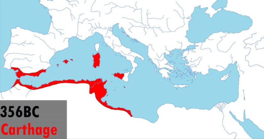
…and the powerful ancient city of Carthage was located in the vicinity of Tunis.

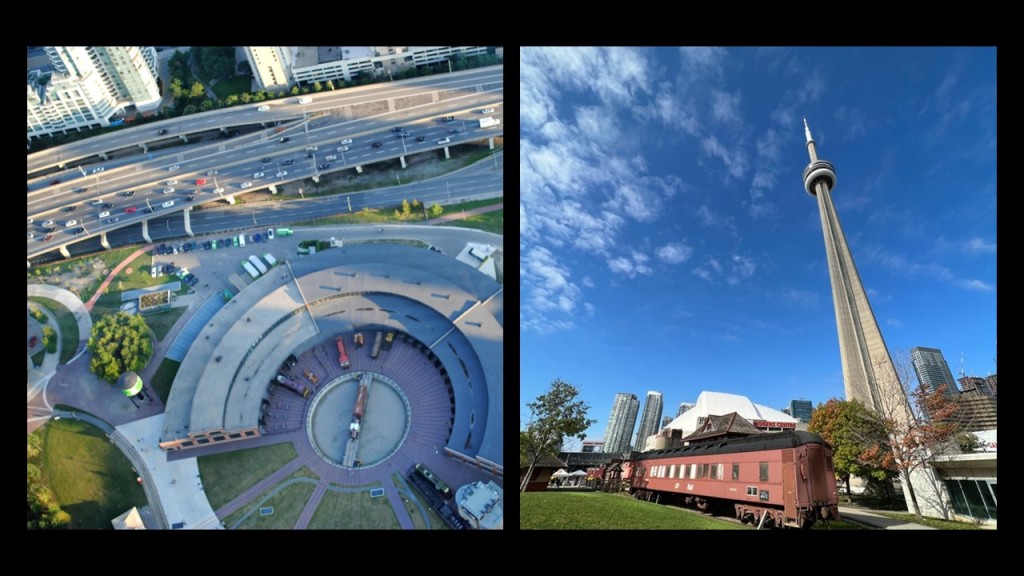
This reconstruction of how Carthage was said to have looked is typical of depictions of it, and its protected harbor called a cothon, which were said to have been generally found in the Phoenician world and which looks remarkably like the former roundhouses of railroad lines everywhere which have been totally removed from the modern world and no longer exist.

Only remnants of roundhouses exist today, like Roundhouse Park in Toronto, located right next to, of all places interestingly enough, the CN Tower.
Carthage was said to have been founded by Phoenician settlers from Tyre and Sidon in the modern-day country of Lebanon, and destroyed by Roman forces in 146 BC at the end of the Third Punic War.

I find it very interesting that there is a narrow strip of the National Forest of Tunisia between A1 Motorway and the coast of Hammamet Bay, between Sousse and the resort town of Hammamet to the North, given the overall desertified nature of the place.
We will see more on the desertification of the region as we move into northern Africa’s Sahara Desert.

There are many olive tree groves south of where the strip of National Forest is located, adjacent to the Gulf of Hammamet Bay, in the vicinity of el Kantaoui Port, north of Sousse Proper.

Olives are Tunisia’s most important natural resource, and Sousse is the center of the production and sale of olive oil in Tunisia.

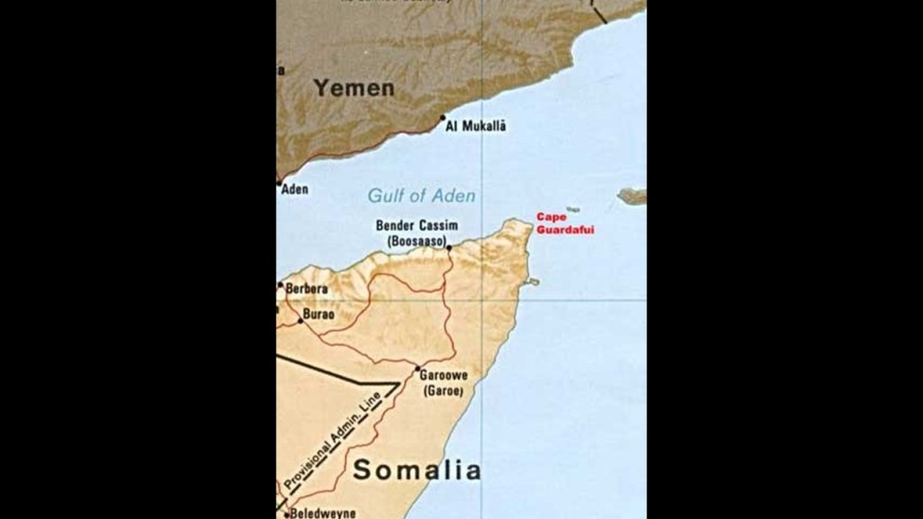
Interestingly, not too long ago in tracking an alignment, I encountered a similar strip of trees of Africa on the northeast coast of Somalia in Alula, the capital of the Bari Region of Puntland on Cape Guardafui.
Alula is situated next a shallow lagoon lined by mangroves, a type of tree that grows in brackish water.
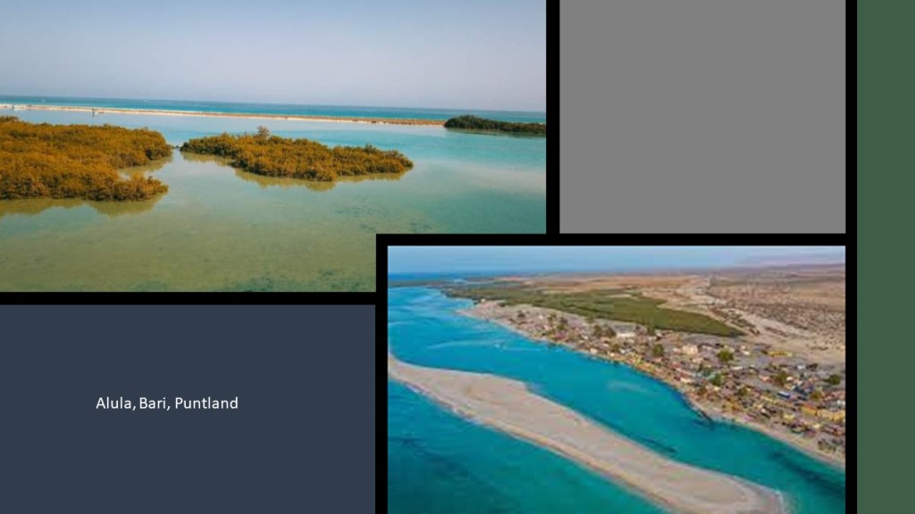
Here is a picture of mangroves covering the coast of this area by Alula on Google Earth.

Mangrove swamps are coastal wetlands characterized by these salt loving trees and shrubs that are typically found in estuaries, where salt water meets freshwater.
Estuaries have water that is salty, dirty & unpleasant, and there are one or more rivers flowing into it, and a connection to the open sea.
I have been speculating for awhile now from my research that the Earth’s estuaries are actually ruined and sunken land that once had the infrastructure of civilization in it.

This region even today produces 1.5-million kilograms, or over 3.3-million pounds, per year of different types of frankincense, an aromatic resin used in incense, perfumes, and essential oils, obtained from Boswellia trees.

Medicinal properties of frankincense include anti-inflammatory and anti-tumor properties.

Cape Guardafui where Alula is located was at one time considered the center of the world’s spice trade, and known as “Aromata,” or the “Cape of Spice,” due to the abundance of spices it produced, including frankincense, cinnamon, and indian spices.
Tunisia, and the coast of North Africa, is the southern boundary of the Mediterranean Sea.
If you break-down the meaning of Mediterranean Sea, you come up with “Middle Earth” Sea.

Interestingly, the Great Pyramid of Giza in Egypt, the northern border of which is on the Mediterranean Sea, has been calculated to be the center of the land mass of the Earth.

Carl Munck in “The Code,” deciphers a shared mathematical code, related to the pyramids of Giza, in the dimensions of the architecture of sacred sites all over the planet, one which encodes longitude & latitude of each that cross-reference other sites.

He shows that this pyramid code is clearly sophisticated and intentional, and perfectly aligned geometrically over long-distances.
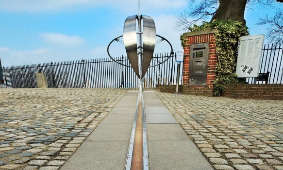
The Great Pyramid was the prime meridian of the Earth until the prime meridian was moved to the Royal Observatory in Greenwich, England…in 1851.
Next, it is interesting to note that approximately 200-miles, or 323-kilometers, almost due south of Sousse is the town of Tataouine, in the governate of Tataouine.
The word the town and region is named for was said to have meant “springs.”
The region is known for its underground dwellings of the Berber inhabitants.

Tataouine in Tunisia was the inspiration for the desert planet of “Tatooine” in “Star Wars,” and was a filming location for “Tattooine” in the movie.

Out of curiousity, since there seems to be quite a bit of disclosure happening in Hollywood movies, I looked up how Tattooine in “Star Wars” became a desert planet.
So as related in the history of “Star Wars,” Once Upon a Time, Tattooine was a thriving world with twin suns, where its advanced people lived peacefully in gleaming cities alongside blue seas, but it was invaded by the Rakatan Infinite Empire, who enslaved the inhabitants.
Though Tatooine’s inhabitants were able eventually drive that Rakata off their world after a virulent plague weakened the invaders, the Rakata retaliated with an orbital bombardment that glassed the surface of the planet and boiled off its oceans, with the glass becoming sand in time.

Hmmm…
Let’s see what else we find in this part of the world!

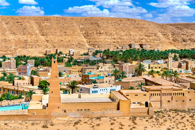
Next on the alignment in Tunisia from Sousse, we come to Kairouan, the capital of the Kairouan Governate and a UNESCO World Heritage Site.

The Great Mosque of Kairouan, also known as the Holy Mosque of Uqba, is considered to be one of the most impressive and largest Islamic monuments in North Africa.
It is one of the oldest places of worship in the Islamic world, said to have been established in 670 AD, and the model for all later mosques in the Maghreb.

The architectural style of the Great Mosque of Kairouan in Tunisia is like that of the Alhambra in Spain, the only location in our historical narrative where a significant Moorish history is openly acknowledged.
Both places share features like courtyards with multiple archways and double-columns.

We are told during the Aghlabid Dynasty between 800 AD and 909 AD, the ruler of Ifriquiya in today’s North Africa, established a University in Kairouan as part of the Great Mosque complex, and that it became a center of education in both Islamic thought and in the secular sciences.
It is said to be in the Guiness World Book of Records as the oldest, currently functional, university in the world.

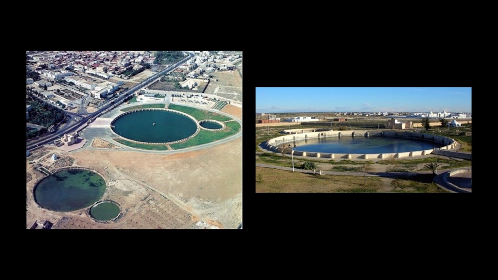
The Aghlabids were said to have built palaces, fortifications, and fine waterworks, of which only the pools remain.
For example, these are called the Aghlabid Basins, said to have been built in the 9th-century as water storage for the Aghlabid Palace, which was on the site of a present-day cemetery in Kairouan.
Jebel Chambi is the next place on the alignment, the highest mountain in the country, standing above the city of Kasserine in western central Tunisia.
With new eyes as of the last year, I now consider the possibility that this was the location of a giant tree.
The summit is covered by a pine forest and is part of Chambi National Park.

Both Kairouan and Kasserine were located on the railway line in this direction from Sousse.

In “On the Trail of Giants in Appalachia and Beyond – Theme 3 The Energy Grid,” I documented findings supporting the idea that suspected giant tree locations, were serving as things like transportation hubs on the Earth’s Energy Grid System for past and present railroad lines, most of which have been replaced by highway routes or recreational trails in today’s world.
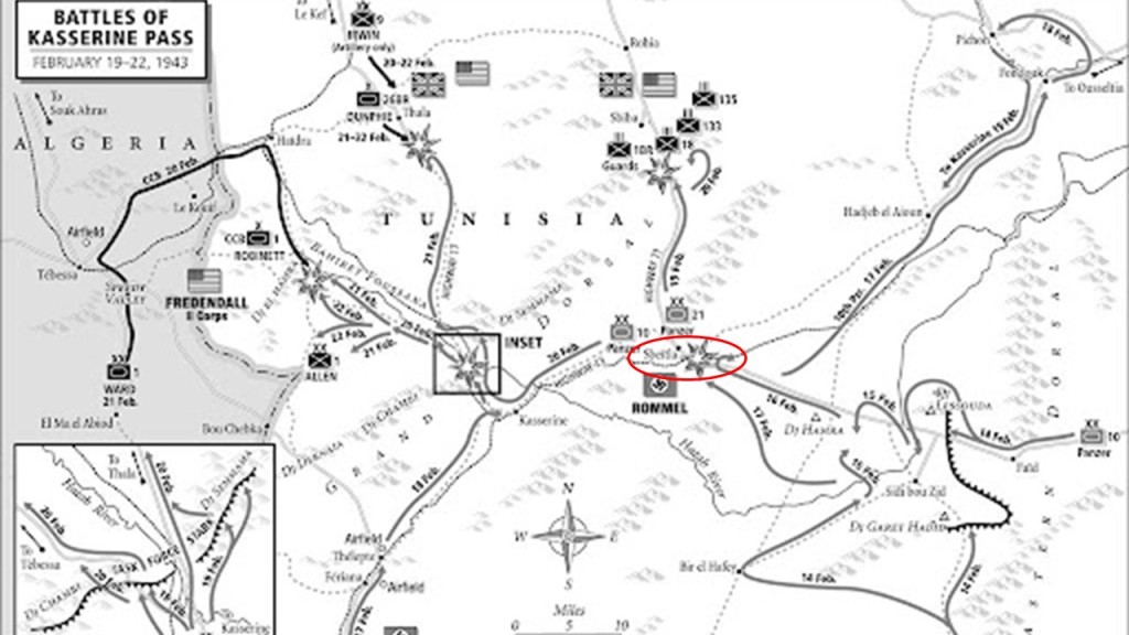
Interestingly, the Battle of Kasserine Pass took place during the Tunisia Campaign of World War II.
It was the first major engagement between American and Axis forces in Africa.

With the Axis German and Italian Forces led by Field Marshall Erwin Rommel, it was an early defeat for Allied forces.

One of the things that happened during the Battle of Kasserine pass was the destruction of a railroad bridge by American troops at Sbeitla.
Interesting that there are so many military engagements historically that have taken place along these alignments I have been tracking – the Napoleonic Wars, World War I, World War II, among other kinds of wars.
It makes me wonder what they were really all about…like maybe damage to, and in many cases, the complete destruction of, the ancient advanced civilization and the earth’s energy grid system.
The even more giant-tree stump-looking Jugurtha Tableland is in Tunisia.

The location of the Jugurtha Tableland is northwest of Kasserine, near Haidra, where as previously mentioned, we are told the railroad was brought in there for lead, phosphate and ore mining, activities also associated with the suspected locations of giant trees.

Haidra was also the location of what was said to be one of the earliest Roman settlements in North Africa.

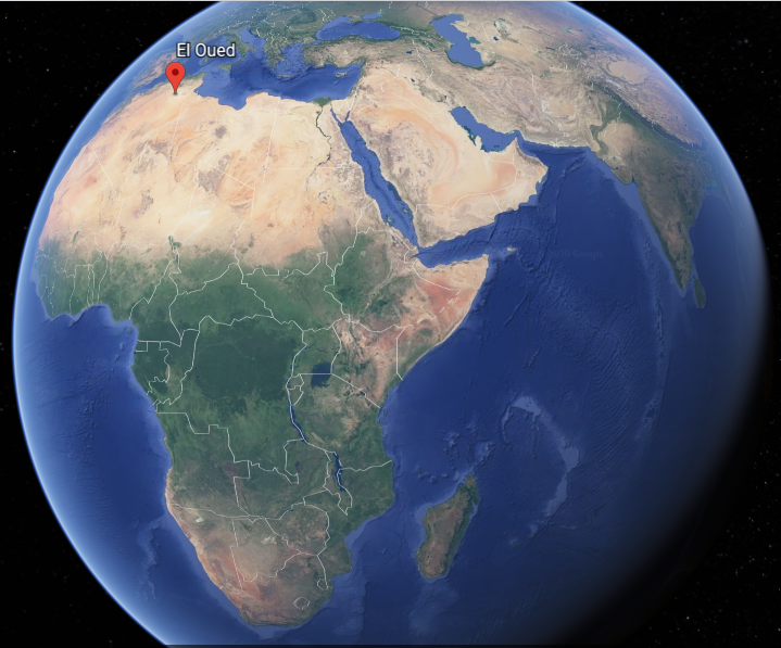
The next place we come to on the alignment is El Oued, the capital of Algeria’s El Oued Province in the Sahara Desert in northeast Algeria.
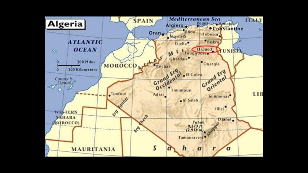
The oasis town of El Oued is watered by an underground river, which allows for date palm cultivation.

It is also known as the “City of a Thousand Domes” since most roofs are domed.

In El Oued Province itself, we find the Chott Melrhir, an endorheic salt lake (a limited drainage basin with no outflow)…

…and the westernmost of a series of depressions, from the Gulf of Gabes in the Mediterranean Sea into the Sahara.

The Grand Erg Oriental, or Great Eastern Sand Sea, is in the southern part of the province, is a field of sand dunes.
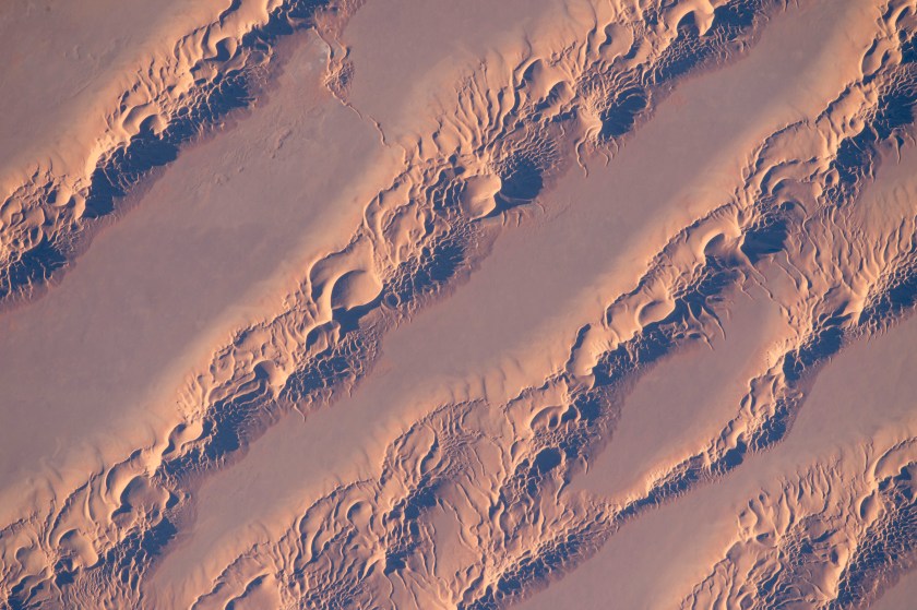
Can’t help but wonder if there is enduring infrastructure underneath all that sand!

The Grand Erg Oriental used to be associated with the Wadi Igharghar, described as a dry and mostly buried river with a sizeable number of tributaries (a canal-system perhaps?) that flowed north into the Erg from the Ahaggar Mountains to the south of it.

At one time, not only did the Sahara Desert have a fertile, savannah-type ecosystem, supporting a wide-and-varied wildlife population, like these life-sized giraffes carved in rock in the Sahara…
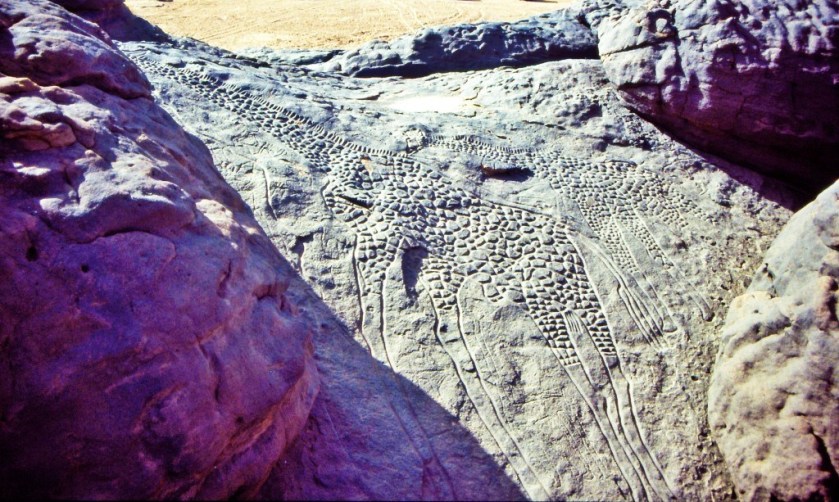
…the region now called the Sahara desert had great forests, including but not limited to, oak, elm, alder, juniper, and pine.
As you can see in this picture, we are taught the desertification of this region started happening a long time ago.
Maybe. Maybe not.
There is so much that we have not been told about!
The silence about the history of this region of the world in the present-day is deafening.

This is a good place to bring up desertification of certain places around the world, like the Sahara Desert.
I mean, is all of the desertification around the world the result of natural processes over time? Or did something happen to cause it all of a sudden that we haven’t been told about?

Next on the alignment from El Oued, we come to the city of Touggourt, the capital of Algeria’s Touggourt Province, and a former Sultanate.
The Sultanate was abolished by French colonial authorities in Algeria in 1854, and after about a 50-year period of time, it became an autonomous administrative district in what was called the Southern Territories of Algeria.

Touggourt is situated next to an extensive system of oases which supports palm plantations and other agriculture in a 31-mile, or 50-kilometer, north to south area. Here is a close-up of place with some kind of agriculture…and where you can see what appears to be what used to be infrastructure in the surrounding desert.

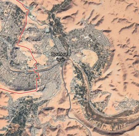
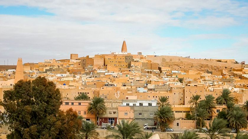
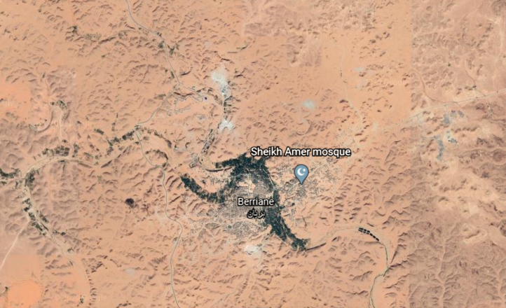
The next place on the alignment is Ghardaia, the capital of Algeria’s Ghardaia Province.

It lies along the west bank of the Wadi Mzab, described as a dry riverbed.
I couldn’t find a picture of the mostly underground Wadi Igharghar back in the Grand Erg Oriental, but it is not hard to find pictures of the Wadi Mzab…showing masonry banks.

The Wadi M’zab Valley in Ghardaia Province has been a UNESCO World Heritage Site since 1982.
The cities of the Wadi M’zab Valley are seven in number, with five built close together, and two lie further out.
Ghardaia is upstream of the other four cities that form what is called the “pentapole,” and is the commercial capital of the Mzab…

…with its dominating mosque…

…then next downstream comes Melika…

…with its unique-looking Sheikh Sidi Aissa Cemetery…

…then we come to Beni Isguen…

…the most traditional city of the Mzab Valley, and in which any visitor must be accompanied by an authorized guide or member of the community…

…next we come to Bounoura…
…meaning “the Luminous…”
…and El Atteuf…
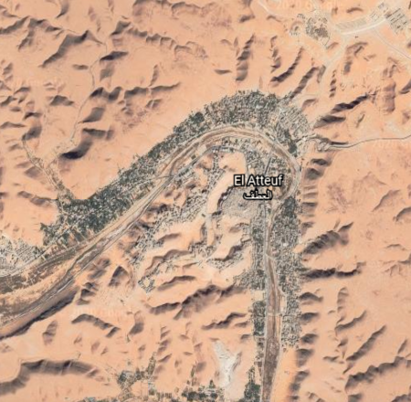
…which means “The Turn…”
…and all five are close together on the S-shaped river bends of the Wadi Mzab.

The other two cities of that constitute the seven cities are:
Berriane, located on National Road 1, one of the country’s important highways…
…and El Guerrara, on the passageway for caravans crossing the Sahara, from east-to-west, and north-to-south…

…and are located further out from the other five.
Taking a look at the Pleiades, I think the seven cities of the UNESCO World Heritage Site of the Wadi M’zab Valley could possibly be a terrestrial star map of the Pleiades, also known as the Seven Sisters.

Before I leave Algeria, and head into Mauretania, there is one more place I would like to bring to your attention.
You can easily find this information if you look for it, as it is not hidden from us like so much else, but most people don’t know about it.
While Reggane is not directly on the alignment I am tracking, it is relatively close to it.
Reggane is the capital of Algeria ‘s Adrar Province.

France began its nuclear testing program in Reggane in 1960 – 1961, before Algeria’s independence.
They conducted four atmospheric nuclear tests, which contaminated the Sahara Desert with plutonium, negatively impacting those who live here to this day – not only Reggane, but far beyond.
Between 1960 and 1966, a total of 17 nuclear tests were conducted in the Reggane District of Algeria.
It was called Africa’s Hiroshima.
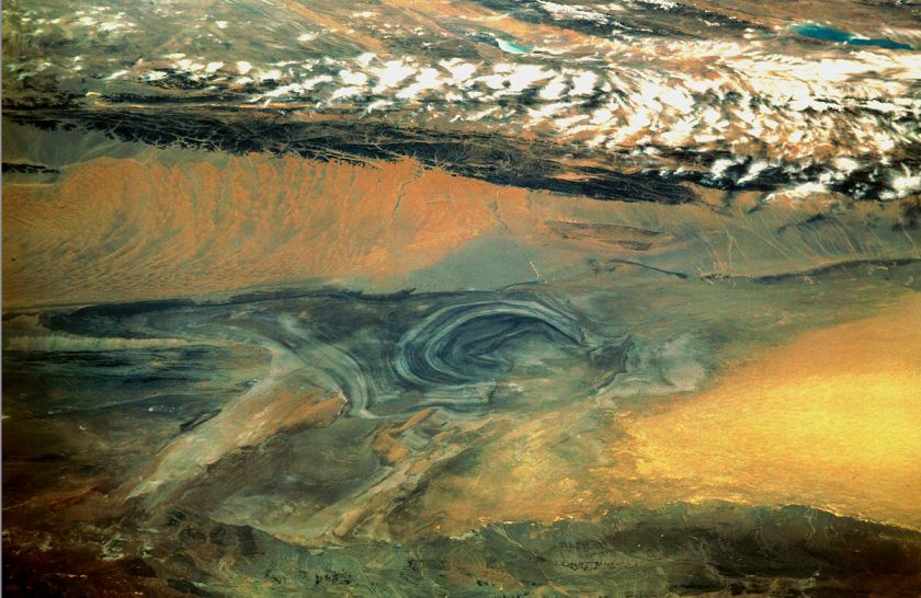
The next place I am going to highlight on the alignment is the Eye of the Sahara, which is near Ouadane in central Mauretania.
It is visible from space, and has been used by NASA astronauts as a visual landmark.

The Blue Eye of the Sahara, also known as the Richat Structure, is described as a geological formation in the Sahara Desert that resembles an enormous bulls-eye.
It is highly symmetrical, and measures 25-miles, or 40-kilometers in diameter.
Three nested rings dip outwards from the center of the structure, and are all equidistant from the center.

Some have speculated that this configuration matches that of Atlantis as described by Plato.
If it is a man-made structure, and not natural as many want us to believe, why does it look melted?

It resembles Lop Nur, an ancient salt lake in the Takla Maklan Desert in the Southeastern portion of the Uighur Autonomous Region of Xinjiang in China…
…and the location where the Chinese Nuclear Weapons Test Base had four nuclear testing zones, starting in 1959 – with H-Bomb detonation in 1967 – until 1996, with 45 nuclear tests conducted.

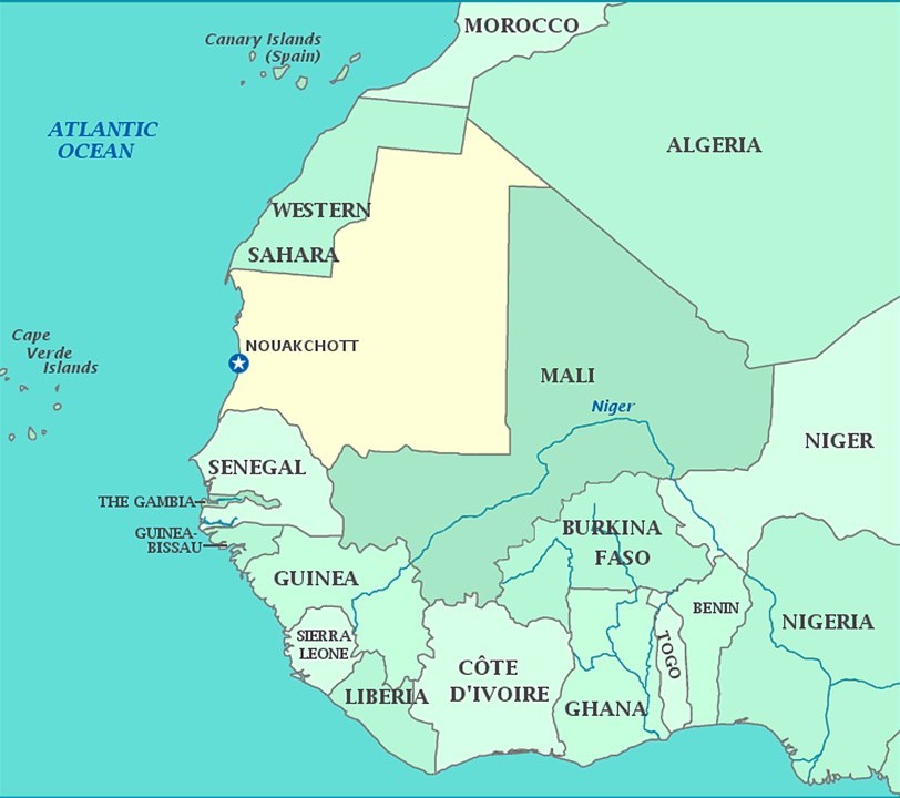
Next, we come to Nouakchott, the capital and largest city of Mauretania.
It is one of the largest cities of the Sahel, the ecoclimatic and biogeographic zone of transition in Africa between the Sahara to the North, and the Sudanian Savannah to the South.

We are told that Nouakchott was a large fortified fishing village in pre-colonial times and under French rule.
Now…why would a fishing village be fortified?
I am unable to find any historic photos of Nouakchott on the internet to see what it might have looked like even around the early 1900s.
I did find this illustration of the skyline of Nouakchott…

…and this Mauritanian bank note depicting some of the country’s infrastructure.

Then I look at the absolutely devastated-looking desert landscape of the whole country from Google Earth, and it makes me wonder about what we are really looking at here.

So I delved into the history of Mauretania to see what I could find out about what we are told in the historical record we have been given.
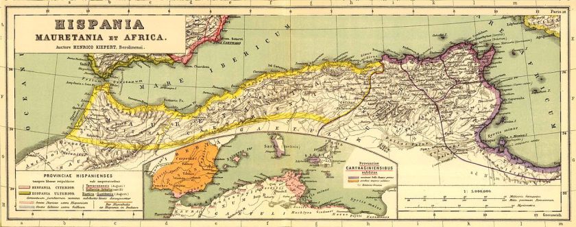
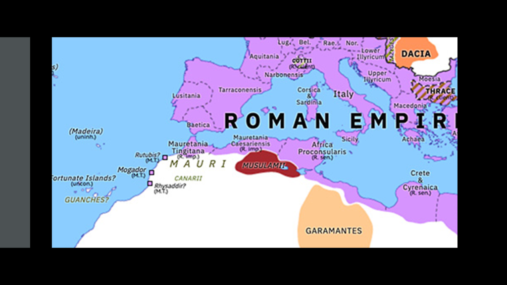
We are told that Mauretania was the Latin name for a region in the ancient Maghreb.
It stretched from central present-day Algeria, westward to the Atlantic, covering northern Morocco, and southward to the Atlas Mountains, and included the cities of Ceuta and Melilla, which are autonomous cities of Spain in North Africa.
Ceuta lies on Strait of Gibraltar, the boundary between the Mediterranean Sea and the Atlantic Ocean…
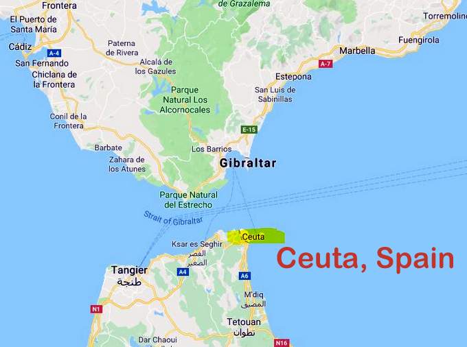
…and is the location of Jebel Musa, or Mount Moses, considered by some to be the southern Pillar of Hercules…

…and the Rock of Gibraltar across the Strait of Gibraltar considered to be the northern Pillar of Hercules.
And could they have possibly been former giant trees as well?
Gibraltar is a British Overseas Territory in southern Spain.
Interesting that both of these places are governed by countries outside of the one of they are physically located in.

The largely intact Royal Walls of Ceuta are described as a line of fortifications said to have been built by the Portuguese in the 1540s.

Melilla, the other autonomous city of Spain in North Africa along with Ceuta, said to mean the “White One”…

…has the fortress walls of Old Melilla, said to have been built in the 16th- and 17th-centuries, after the Spanish conquest of the region in 1496.

Nevertheless, we are told that the native inhabitants of Mauretania were seminomadic pastoralists of Berber ancestry, and known to the Romans as Mauri…or…Moors.
Berbers are called an ethnic group of several nations, mostly indigenous to Mauritania, Morocco, Tunisia, Algeria, Tunisia, Libya, northern Mali, northern Niger, and a small part of western Egypt.
Both Ceuta and Melilla are officially claimed by Morocco.
The term Barbary Coast, and Barbaria was said to have been used by Europeans from the 16th-century to the early 19th-century to refer to the regions of North Africa inhabited by the Berber people.

We are taught that the kings of Mauretania became Roman vassals in 27 BC, and that in 44 AD, Mauretania was annexed to Rome as two different provinces – Mauretania Tingitana, or present-day northern Morocco, and Mauretania Caesariensis, or present-day northern Algeria.
Then, during the Crisis of the Third Century, a period of time when the Roman Empire almost collapsed between 235 and 284 AD, we are told, because of invasions and overall instability within the empire…

…that parts of Mauretania were reconquered by Berber tribes, and Romano-Moorish Kingdoms were established during the 6th- and 7th-centuries.

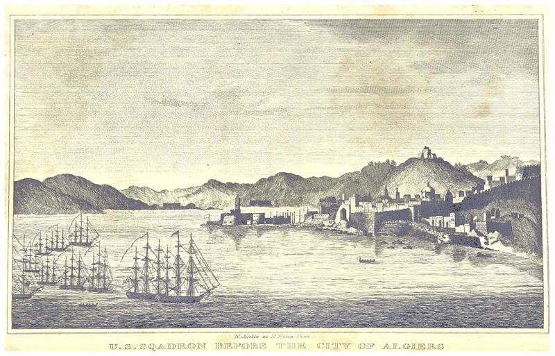
Fast forward through time to the Barbary Wars, which were a series of conflicts culminating in two main wars fought between the United States, Sweden, and the Barbary States of the Ottoman Empire in the late 18th- and early 19th-century.
We are told that Barbary pirates demanded tribute from American vessels in the Mediterranean Sea, and in 1801, President Thomas Jefferson refused to pay, and sent a U. S. Naval fleet to the Mediterranean in May of that year, and which lasted until 1805.

The naval fleet commenced bombarding various fortified “pirate” cities in present-day Libya, Tunisia, and Algeria, over the next three years until concessions of fair passage were extracted from their rulers, which were most likely the Deys of Tripoli, Tunis, and Algiers, in the First Barbary War.
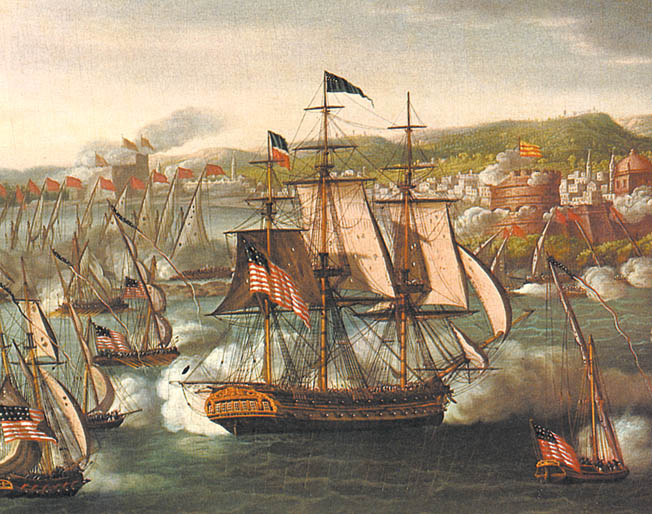
The second Barbary War took place in 1815 between the United States and the Barbary States, and we are told, brought to an end the American practice of paying tribute to the “pirate” states and marked the beginning of the end of piracy in that region.
I am including what information is available about the Barbary Wars because it is noteworthy.
I would love to know what was really going on here with regards to the Barbary Moors, because if information is difficult to find if it even exists.
Mauretania was administered as a French colony during the first-half of the twentieth-century, achieving independence in 1960, and Nouakchott becoming its capital in 1958, at which time it was described as being a mid-size village of little importance.

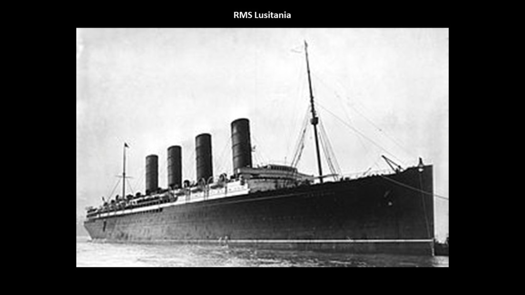
By the way, an interesting side-note is the RMS Mauretania, a passenger ocean liner launched on September 20th of 1906, was said to have been named for the ancient Roman Province of Mauretania, and not the modern country…

…and was the sister ship to the RMS Lusitania, named for the Roman province directly to the north of Mauretania, across the Strait of Gibraltar, which is famous in history for having been sunk by a German u-boat in 1915 off the coast of Ireland.
The iron ore trains of Mauretania are some of the longest, if not the longest, in world, at 1.6-miles, or 2.5-kilometers, long…
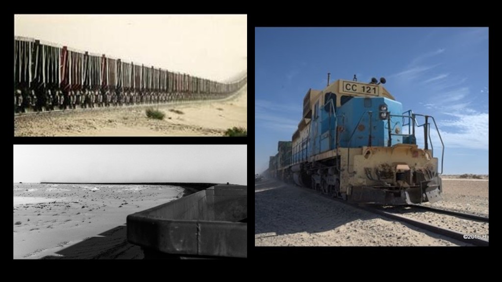
…hauling iron ore, people and goods, 405-miles, or 652-kilometers between the mining town of Zouerat on the west side of Kediet ej Jill, the highest peak in Mauretania, through the Sahara Desert, to the port city of Nouadhibou on Mauretania’s coast.

Atar is situated on the upper corner of the eyelid of the Eye of the Sahara, and is 213-miles, or 343-kilometers, south of Zouerat and Kediet ej Jill, and Chinguetti is located on the lower lid of the Eye, to the southest of Atar.

The Adrar Plateau Mountains stretch east to west between Atar and Chinguetti.

This is a view on the top left in the Amogjar Pass between Atar and Chinguetti in Mauretania, compared with similar-looking features at Thule, Greenland on the top right; Cutimbo in Peru on the bottom left; and in the Village of Oak Creek, in Sedona, Arizona on the bottom right.
Again, have to wonder if we are looking at former giant tree locations at all these places being mentioned here.

Chinguetti is called the Holy City of the Sahara, and venerated as one of the most holy cities of Islam…

…and has some of the world’s oldest surviving copies of Korans and other documents.

Then there’s Ouadane, situated pretty darn close to the eyeball of the Eye of the Sahara, what was once one of Africa’s key trading posts, and a UNESCO World Heritage site today.

It is largely in ruins, though there is a settlement of people still living there outside the gates.

I noticed the Banc d’Arguin National Park on the coast, another UNESCO World Heritage Site located north of Nouakchott, and went there to take a look, as I consistently find that for as much of the ancient civilization as is destroyed, neglected, or incorporated in unprotected places, much is preserved intact in parks.

The island of Arguin in the Bay of Arguin was first thing I noticed when I looked at Google Earth.

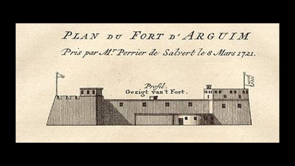
The interesting thing about Arguin, part of the National Park, is that while there is not much going on there now…

…at one time there was a lot going on there, including a star fort, said to have been built by the Dutch, which doesn’t appear to exist any more.
We are told that starting in 1443, it became a part of the Portuguese Empire; and, at different times over the centuries, it was part of the Dutch Empire; part of the territories and provinces of Prussia; and part of the French overseas empire.
The shallows of the Banc d’Arguin National Park are said to be remnants of a vast river delta from a time when waters flowed from what is now the Sahara Desert…
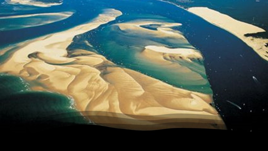
…and the Banc d’Arguin is a major breeding site for migratory birds, and its surrounding waters are some of the richest fishing waters in western Africa, serving as nesting grounds for the region.

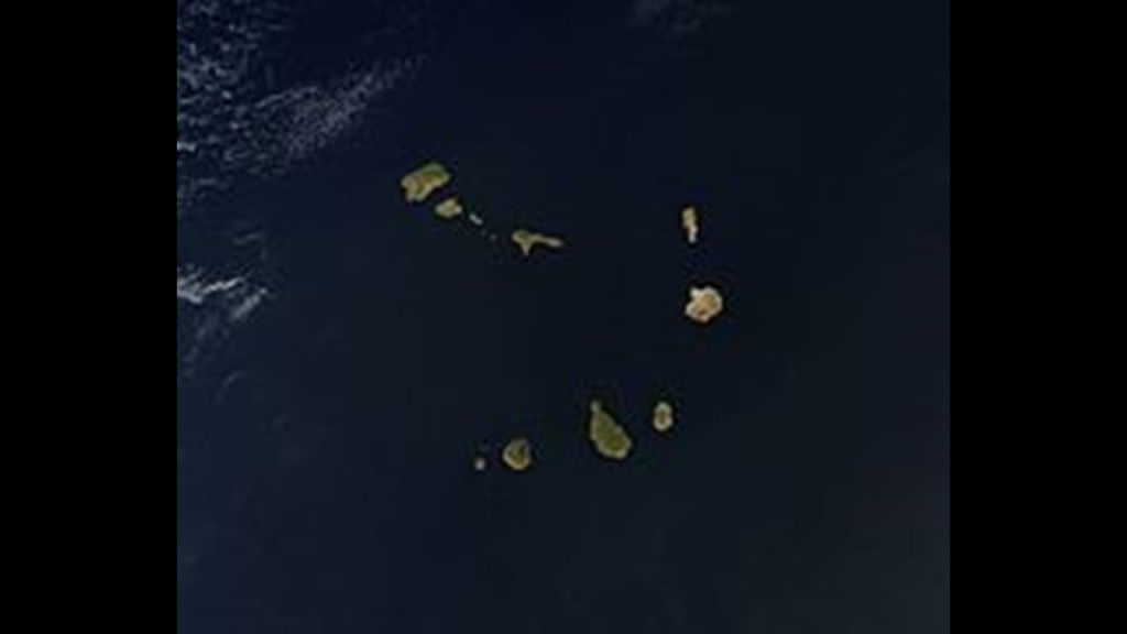
From Nouakchott, the next place we come to on the alignment are the Cape Verde Islands.

The island Republic of Cape Verde is 350-miles, or 570-kilometers, off the coast of western Africa, and consists of 10 islands, divided into two groups.
One group is called the Barlavento, or Windward, islands of:
Sando Antao; Sao Vicente; Santa Luzia; Sao Nicolau; Sal; and Boavista.
The other group is called the Sotavento, or Leeward, islands of:
Santiago; Maio; Fogo; and Brava.
They are part of what is called “Macaronesia,” a collection of four archipelagos in the North Atlantic Ocean off the coasts of Africa and Europe, also including the Canary Islands, Madeira, and the Azores.

Santiago is the country’s largest island, and where its capital, Praia, is located.

We are told the islands were uninhabited before the arrival of Portuguese and Genoese navigators in 1456, with Portuguese settlers arriving in 1462 and founding a settlement called Ribeira Grande, now called Cidade Velha, the historic center of which is a UNESCO World Heritage Site.
These are what appear to be the very old stone ruins of what is called Se Catedral in Cidade Velha.

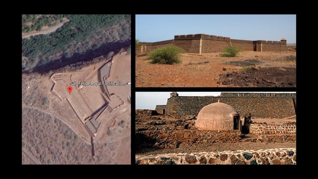
There is also an intact star fort in Cidade Velha, called the Fort Real de Sao Filipe, said to have been built by the Portuguese between 1587 and 1593, and part of a system of defense for the city, which included six smaller forts on the coast and a wall along the port that apparently no longer exists.
Moving over to look at Praia, the capital city, I see the familiar shape of the harbor there, compared for example, to the harbor back in Sousse, Tunisia, on the other side of Africa.
The red dots mark where lighthouses are located, and I typically find pairs of lighthouses at harbor entrances around the world…

…like those back at Sousse.

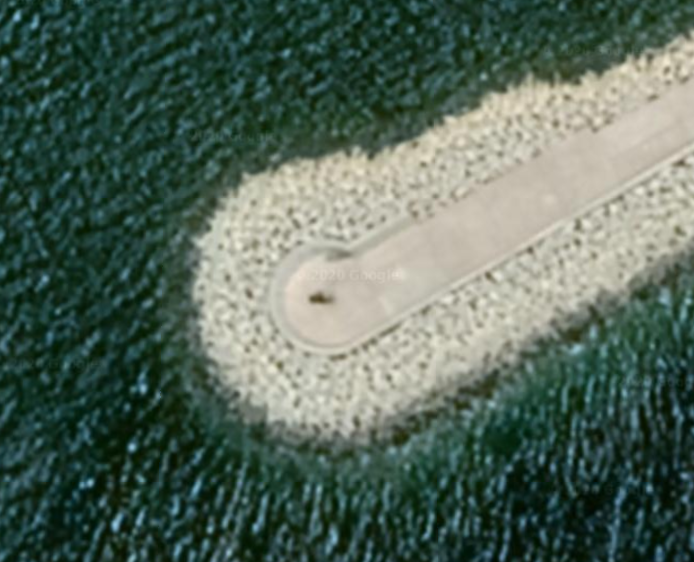
The Farol de Dona Maria Pia is the lighthouse at the southernmost point of the island of Santiago at the entrance of Praia Harbor.

Based on what I have found at other locations with a similar harbor configuration, I would expect to find a lighthouse at the head of the opposite jetty.
But there isn’t one.
It looks like something is standing there, but not a lighthouse, and I could find no record of one being there.
Lastly, it is interesting to note that the Cape Verde Islands are specifically mentioned in the Inter Cetera Bull, issued by Pope Alexander VI on May 4th of 1493.
This papal bull essentially authorized the land grab of the lands of the Moorish civilization in the Americas, and became a major document in the development of subsequent legal doctrines regarding claims of empire in the “New World.”
The bull assigned to Castile “the exclusive right to acquire territory, to trade in, or even approach the lands laying west of the meridian situated one hundred leagues west of the Azores and Cape Verde Islands, except for any lands actually possessed by any other Christian prince beyond this meridian prior to Christmas, 1492.”
In the historical narrative we have been given, this papal bull was issued a year after the Fall of Grenada, on January 2nd, 1492, effectively ending Moorish rule in Spain when Muhammad XII surrendered.

It is important to note that the 1452 “Dum Diversas” papal bull of Pope Nicholas V granted the Crown of Portugal full and free permission to invade, search out, capture and subjugate unbelievers and enemies of Christ wherever they may be…and to reduce their persons into perpetual slavery…

…and his 1455 “Romanus Pontifex” papal bull was a follow-up to the “Dum Diversas,” confirming the Crown of Portugal’s dominion over all lands discovered or conquered during the Age of Discovery, encouraging the seizure of the lands of the Saracens, pagans, and other enemies of Christ, and repeated the earlier bull’s permission for the enslavement of such peoples.

While it is important to mention that “saracen” was a term for Muslims widely used in Europe, it is also the name given to giant megalithic standing stones in Great Britain and other places called sarsen, shortened from saracen, stones.

These three papal bulls – the “Dum Diversas,” “Romanus Pontifex,” and “Inter Cetera” – were to become major documents in the development of subsequent legal doctrines regarding claims of empire in the “New World.”
As an example of this, they were cited in the matter of the lands claimed after the “Lewis and Clark Expedition,” also known to history as the “Corps of Discovery,” which took place between 1804 and 1806.
In our historical narrative, after the Corps of Discovery arrived back in St. Louis on September 23rd of 1806.
European colonialism intentionally created divides over the landmass of the earth, creating new countries from lands that were taken, as well as creating divisions and discords between peoples that originally existed in harmony worldwide.
This particular journey across North Africa to the Cape Verde Islands diagrams ways in which European colonizers consolidated power and control over the landmass of the Earth, and raises a lot of questions about the nature of what exactly caused the devastation and desertification throughout this region.
I for one don’t believe it was caused by natural processes over long periods of time as we are taught to believe.
I believe that Earth’s people and grid system were deliberately hijacked by dark beings with a negative agenda, who don’t want us to wake up to our true history and who we really are, and have worked very hard to keep this from happening!

I also believe that the destruction of the Earth’s surface was deliberately caused, and that the original ancient advanced Moorish civilization was wiped-out, erased from our collective memory, and that a new historical narrative was created, based on the underpinnings of the original civilization, but original meanings and intents were twisted and subverted in order to create a system of control for Humanity.

One more thought before I end this post.
I absolutely believe they are not going to get away with what they have done to the Earth and to us, and that we have a much better future than what was planned for us.
They have lost control of the narrative no matter how hard they try to get it back.

No matter how things look on the surface, it’s alway the darkest before the dawn.


God bless you, Michelle, for your incredibly thorough work. Your devotion to truth is remarkable and fills the world with hope.
LikeLike
Thank you so much!
LikeLike