What is it Exactly About the World’s Disputed Islands?

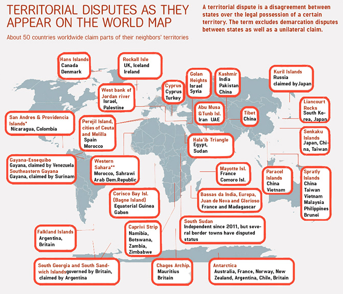
In my journey tracking cities and places in aligment with each other around the world, I kept coming across obscure, seemingly insignificant islands and island groups that are the subjects of territorial disputes between countries, many of which are still on-going in the present day.

I first published this post in October of 2019.

So I have been wondering about this for a very long time.

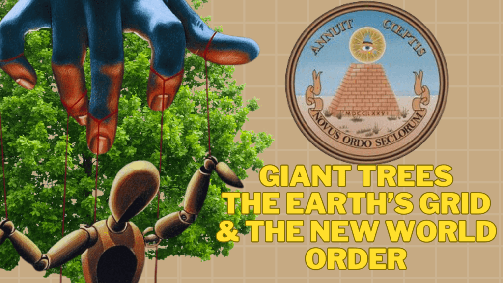
Now that I understand about the existence of Giant Trees with the help of Chad Williams of the “Deeper Conversations with Chad” YouTube channel, and their importance on the Earth’s grid system, I have a likely answer to the question posed in the title of this video…”What is it Exactly About the World’s Disputed Islands!”

In my latest conversation with Chad, “Giant Trees, the Earth’s Grid, and the New World Order,” among many other things, we talked about how the European Colonizers were going after tiny remote islands to claim for their countries.

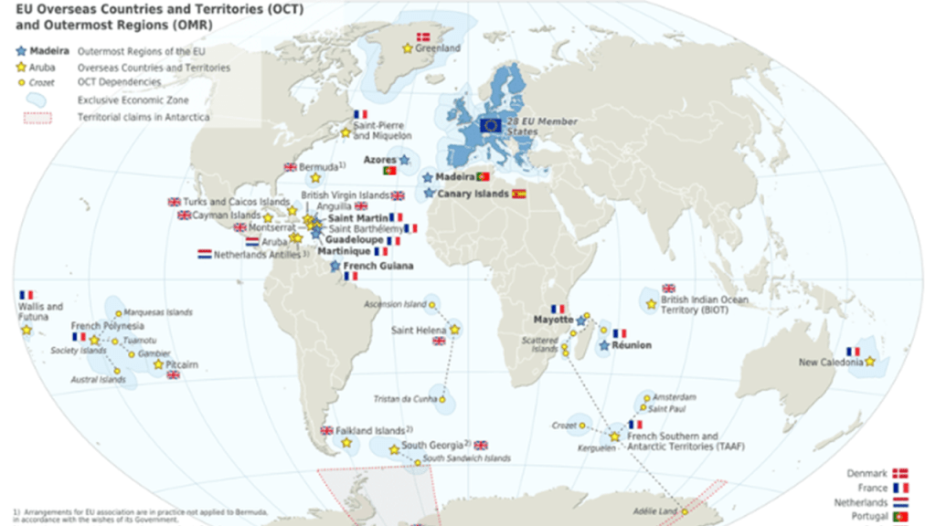
We discussed a number of these remote islands from the perspective that they were former giant tree locations, as I had come across many of these islands when tracking alignments that were claimed by different European Countries as “Overseas Countries, Territories and Outermost Regions.”

We also discussed this illustration that Chad found in his research that appears to depict volcanoes connected by a root system exploding simultaneously all over the Earth.

This could provide an explanation as to why the giant trees don’t look like trees any more, and are called by all manner of names, including “volcano.”

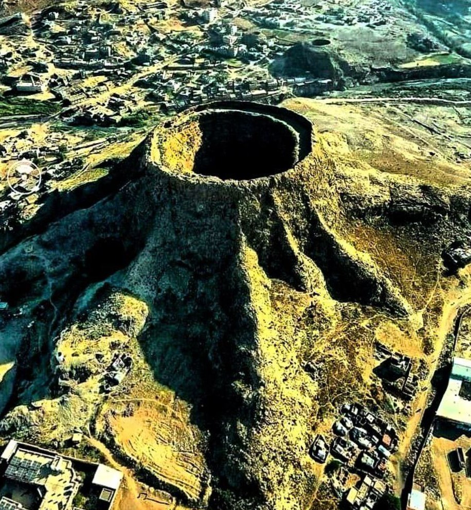
There apparently is a connection to volcanism with these giant trees that has been completely left out of our awareness, as seen in this photo of the tree-trunk-looking Harra of Arhab volcano in Yemen.

As I said at the beginning of this post, I also kept coming across obscure, seemingly insignificant islands and island groups that are the subjects of territorial disputes between countries, many of which are still on-going in the present day, in my journey tracking cities and places in alignment with each other around the world, and in many cases, the odd stories associated with these disputed islands.

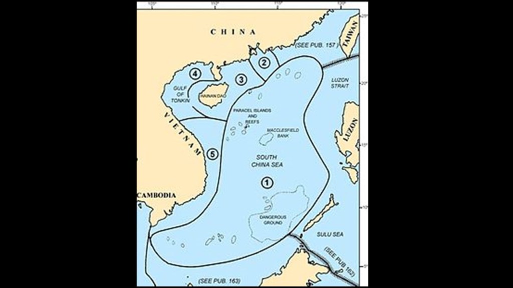
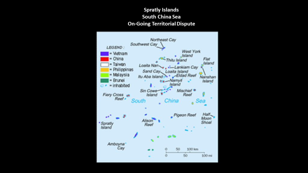
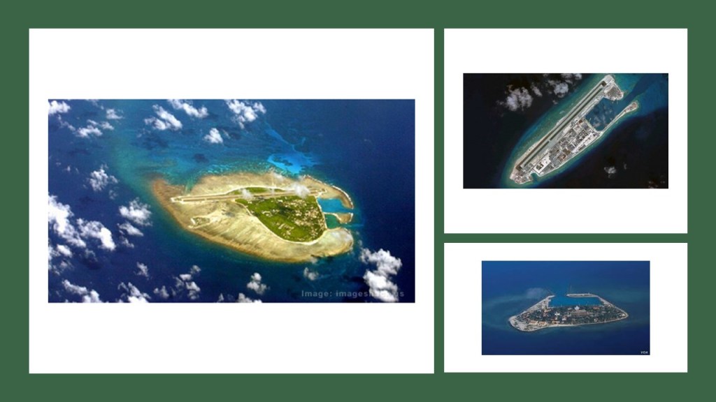
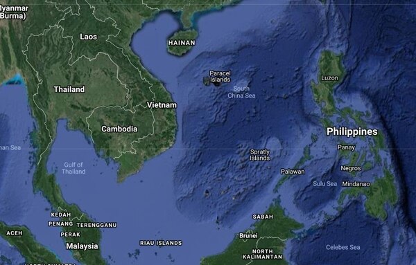
I will start with the Spratley Islands.

I found the Spratley Islands in the South China Sea when I was following one of the alignments that emanate off of the North American Star Tetrahedron at Merida, Mexico.

They consist of 14 islands or islets; 6 banks; 113 submerged reefs; 35 underwater banks; and 21 underwater shoals.

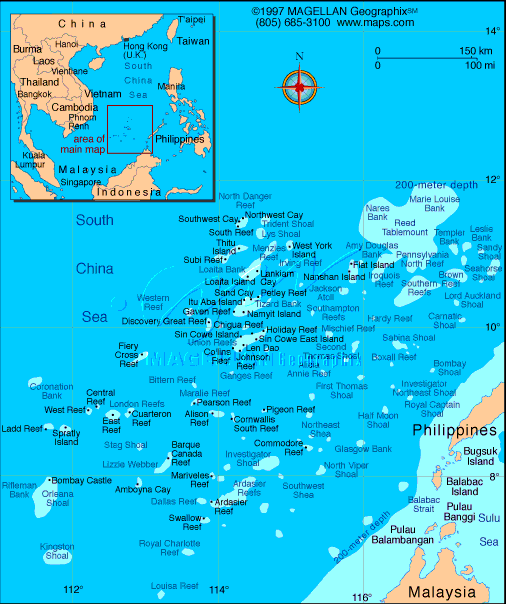
The northeast part of the Spratlys is known as dangerous ground due to low islands; sunken reefs; and degraded sunken atolls.

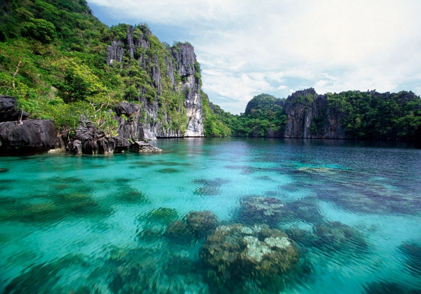
They are located on the alignment just northwest of Palawan Island…

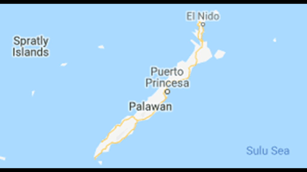
…and Palawan, in the Philippines, is considered by many to be the most beautiful island in the world.

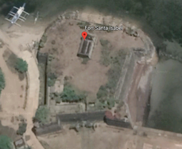
There is a star fort located in Taytay on the island of Palawan called the Fuerza de Santa Isabel.

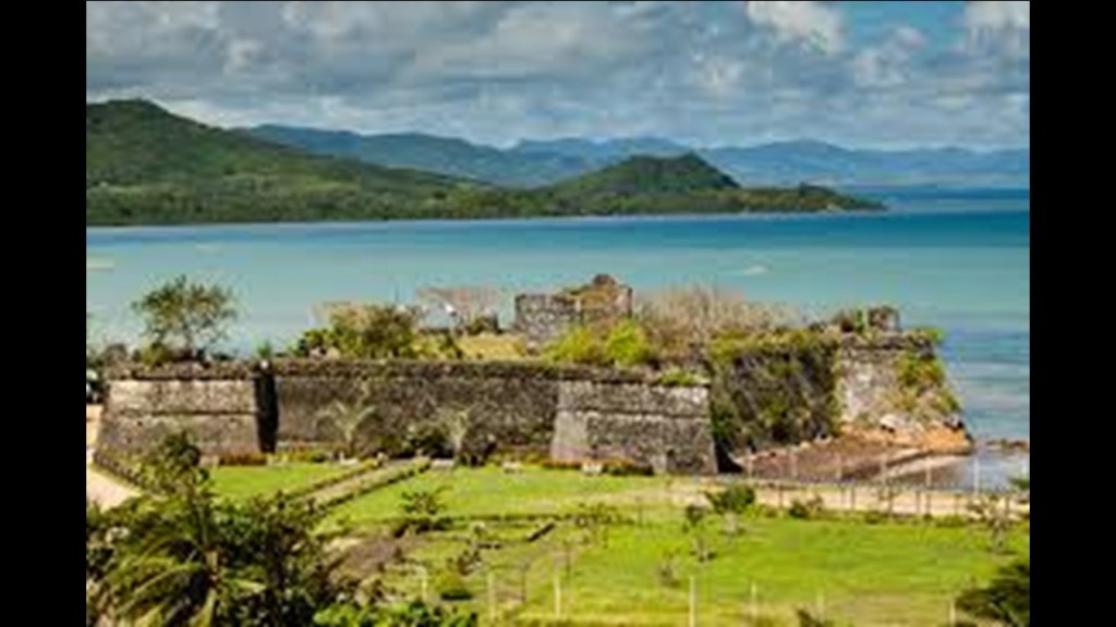
From my extensive research on the physical lay-out of earth-grid alignments, and the frequent occurrence of star forts situated along the Earth grid system worldwide, I believe that star forts functioned as batteries on the Earth’s grid system, and were not originally military in nature as we have been led to believe in our historical narrative.

Back to the Spratley Islands.

The Spratly Islands dispute is an on-going territorial dispute between China, Taiwan, Malaysia, the Philippines, Brunei and Viet Nam concerning “ownership” of the Spratly Islands.

What is it about these islands?

Well, we are told they are of economic and strategic importance; hold reserves of natural gas and oil; productive fisheries; and is a busy area for commercial shipping traffic.

At the time I originally did the research for this post, I speculated that there is a powerful energy component here–whether placement, production, or something else–related to the Earth’s grid lines, and it is becoming clearer and clearer that the giant trees of the Earth were powerful components of the Earth’s grid system.

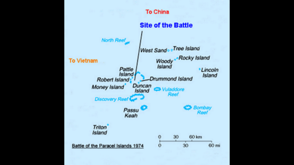
So, for another example of this in the South China Sea, just northwest of the Spratly Islands on the same alignment’s way through Hainan in China, the Paracel Islands are a similar group of islands, reefs, and banks that are strategically located; productive fishing grounds; and which also hold reserves of natural gas and oil.

While they are controlled and operated by China, they are also claimed by Taiwan and Viet Nam.

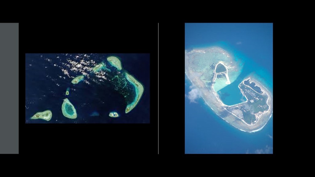
The archipelago consists of 130 small coral islands and reefs, most grouped into the northeast Amphitrite Group or the western Crescent Group.

Island names suggestively include: Tree Island; Woody Island; Pyramid Rock; and Money Island.

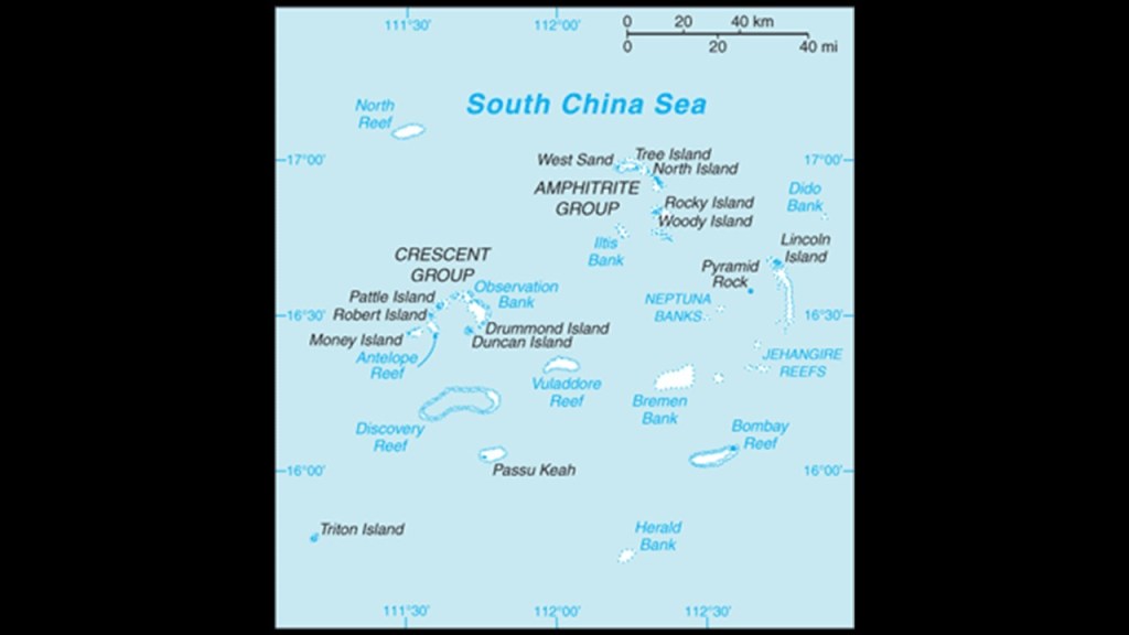
In ancient Greek mythology, Amphitrite was a sea goddess; the wife of Poseidon; and the Queen of the Sea.

The Paracel Islands are also the location of the Dragon Hole, or Sasha Yongle Blue Hole, the world’s deepest known blue hole at 987-feet, or 301-meters, deep.

Former giant tree location perhaps?

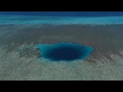
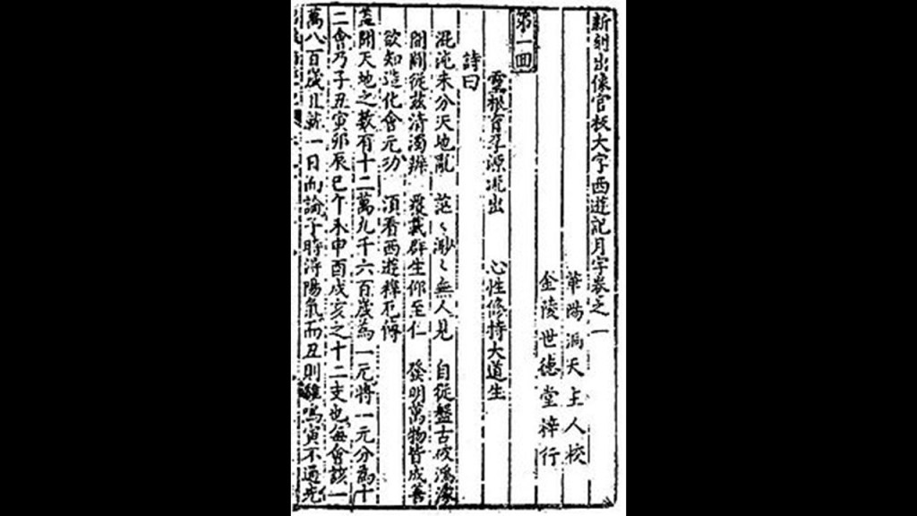
Dragon Hole is called the “Eye of the South China Sea,” and is where the Monkey King found his golden cudgel in the 16th-century Chinese classic of Literature “Journey to the West,” with authorship attributed to Wu Cheng’en.

The Battle of the Paracel Islands was a military engagement between the naval forces of South Vietnam and China in 1974, and was an attempt by the South Vietnamese navy to expel the Chinese navy from the vicinity.

As a result of the battle, China established de facto control over the Paracel Islands.

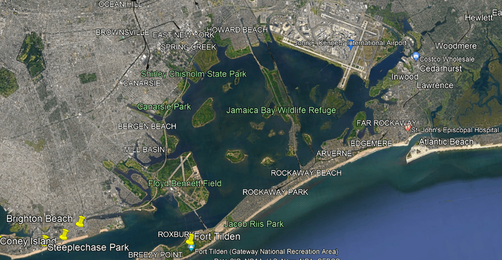
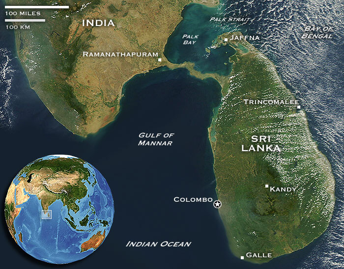
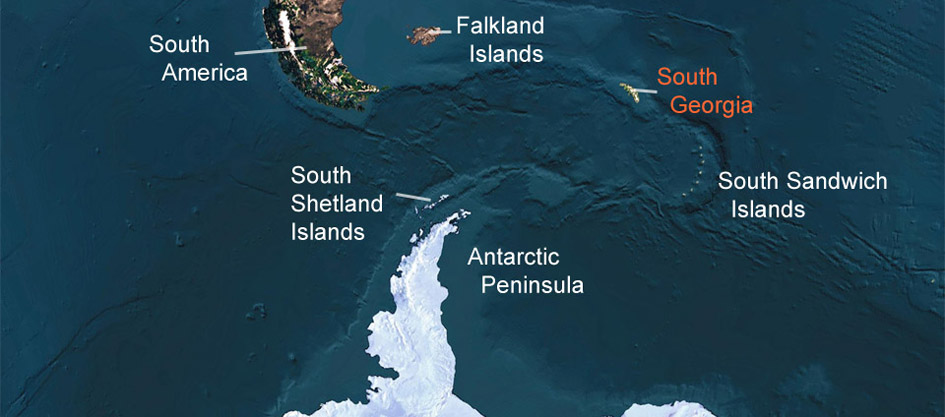
The next place that I am going to look at are the Falkland Islands, an archipelago in the South Atlantic Ocean on the Patagonian Shelf.

They are 300-miles, or 483-kilometers, east of South America’s southern Patagonian coast, and 752-miles, or 1,210-kilometers, from the northern tip of the Antarctic Peninsula, at a latitude of 52-degrees south.

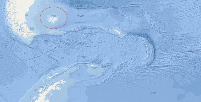
It is a British overseas territory, and consists of two large islands – East Falkland and West Falkland – and 776 smaller islands.

The population of less than 4,000 people are British citizens.

Britain reasserted its rule over the Falklands in 1833, with a colonial presence also including French, Spanish, and Argentine settlements.

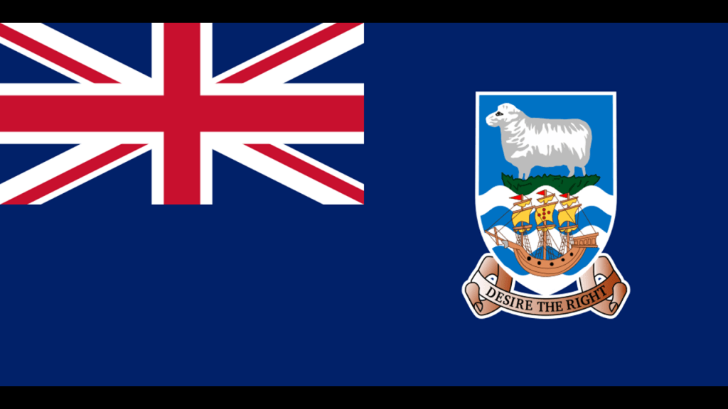
Argentina maintains its claim to the islands.

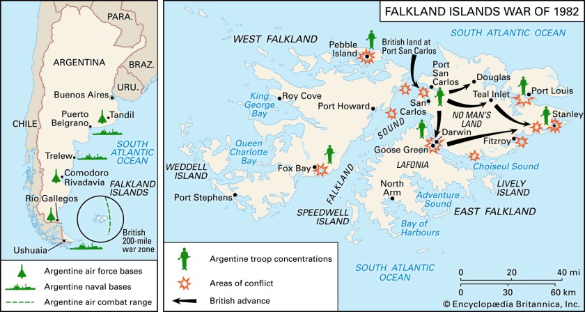
On April 2nd, 1982, Argentine forces occupied the Falkland islands.

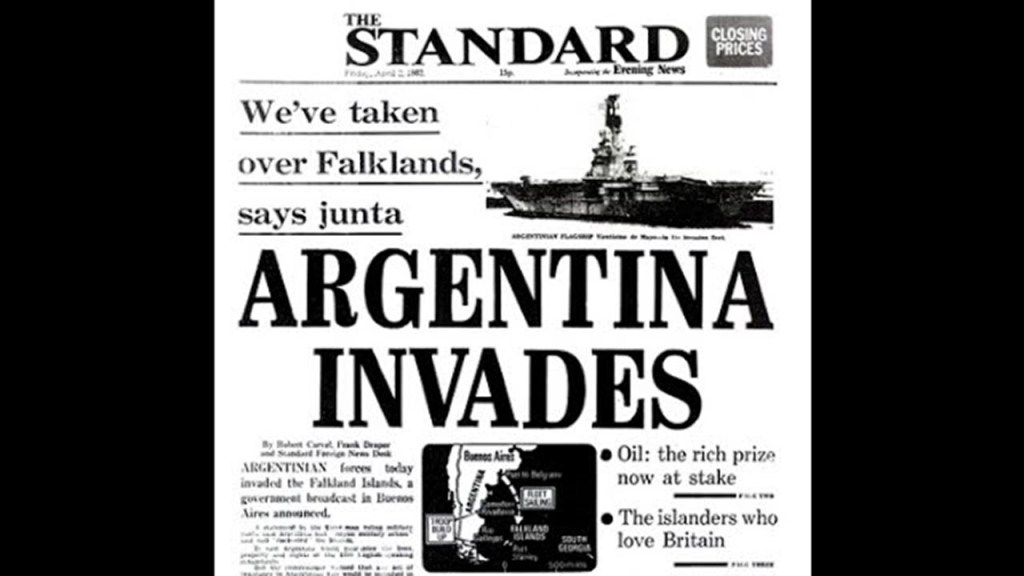
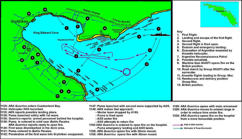
On April 3rd, 1982, Argentine forces seized control of the east coast of South Georgia Island in the Battle of Grytviken, part of the South Sandwich Islands, and another British Overseas Territory near the Falkland Islands that is claimed by Argentina.

On April 5th, 1982, the Falklands War between Argentina and Great Britain started. While not officially declared a war, it was declared a war-zone.

The conflict lasted 74-days, and ended with Argentina’s surrender on June 14th, 1982, returning the islands to British control.

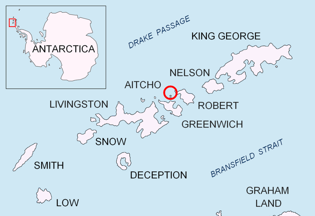
The South Shetland Islands shown here in this map are in the neighborhood of all these little island groups off the southernmost tip of South America, and are a group of Antarctic islands with a total area of 1,424 square-miles, or 3,687 square-kilometers.

By the Antarctic Treaty of December 1st, 1959, the islands’ sovereignty is neither recognized nor disputed by the treaty’s 12 signatories – Argentina, Australia, Belgium, Chile, France, Japan, New Zealand, Norway, South Africa, the Soviet Union, the United Kingdom, and the United States – and they are free for use by any signatory for non-military purposes.

However, the islands have been claimed by Great Britain since 1908, and as part of the British Antarctic Territory since 1962.

They have also been claimed by Chile and Argentina since the 1940s.

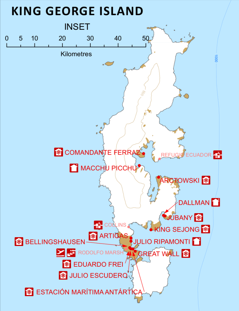
The Chileans have the largest number of research stations on the islands, as well having the Eduardo Frei airbase on King George Island, where the largest number of international research stations are located.

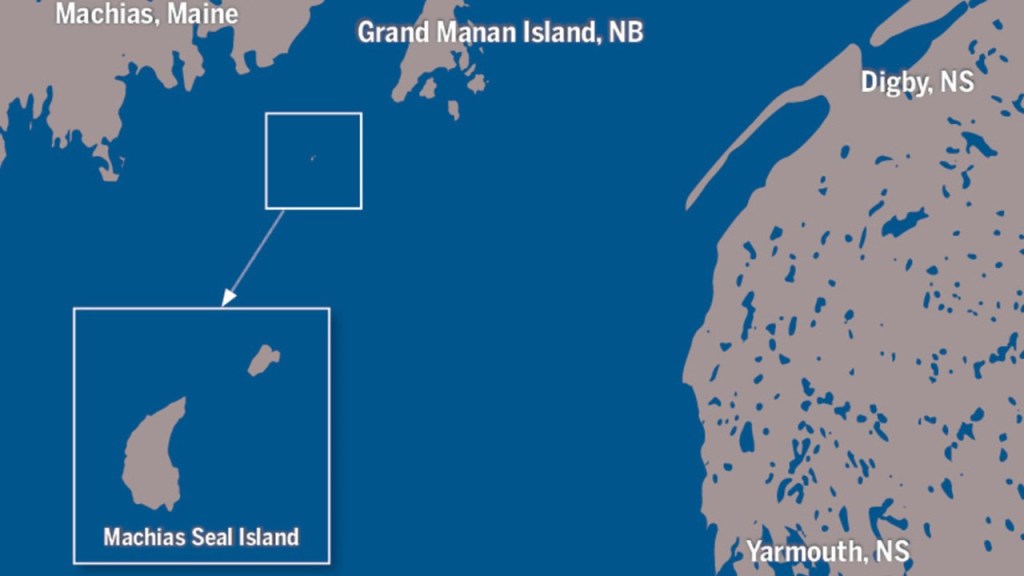
Moving to North America in the northern hemisphere, Machias Seal Island, which has a lighthouse in the center of it manned by the Canadian Coast Guard, is part of an on-going territorial boundary dispute between the United States and Canada.

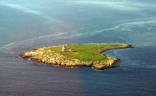
Machias Seal Island is located on the border of the Gulf of Maine in the United States, and the Bay of Fundy in Canada.

Other boundary disputes, not limited to islands, between the United States and Canada include:

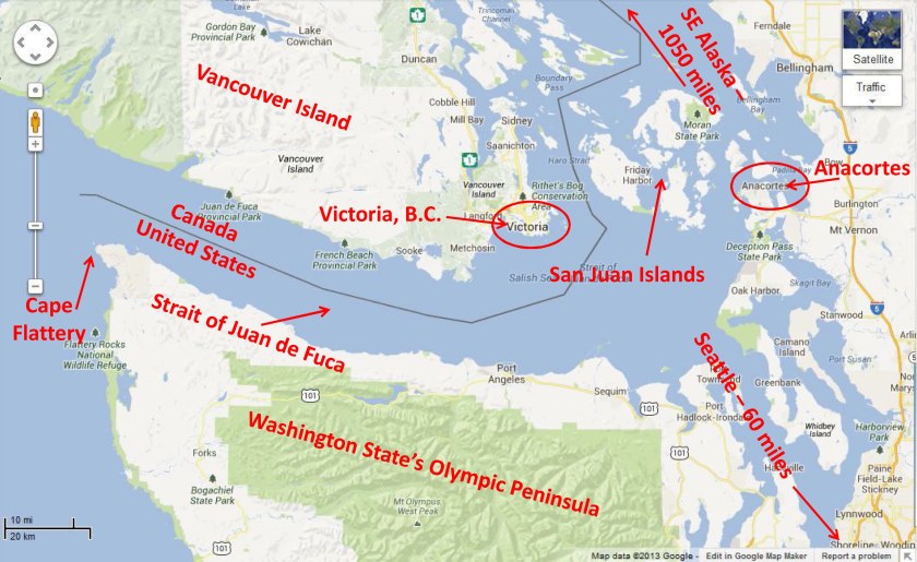
A fishing zone dispute at the mouth of the Juan de Fuca Strait between Washington State and British Columbia, and within which the International boundary between the two countries lies in the middle of the strait.

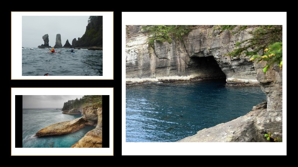
Here are photographs of what Cape Flattery looks like at the mouth of the Juan de Fuca Strait on Washington’s Olympic Peninsula.

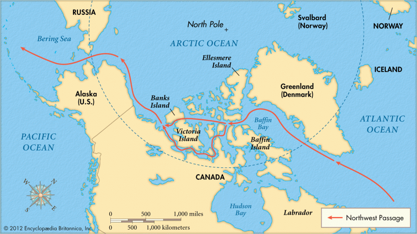
Another area of dispute between the two countries is the Northwest Passage, which Canada claims as part of its internal waters, and the United States regards as an international strait, open to international traffic.

The Dixon Entrance, a strait about 50-miles, or 80-kilometers, long, between Alaska in the United States and British Columbia in Canada is also mutually claimed by both countries.

It is part of the Inside Passage shipping route.

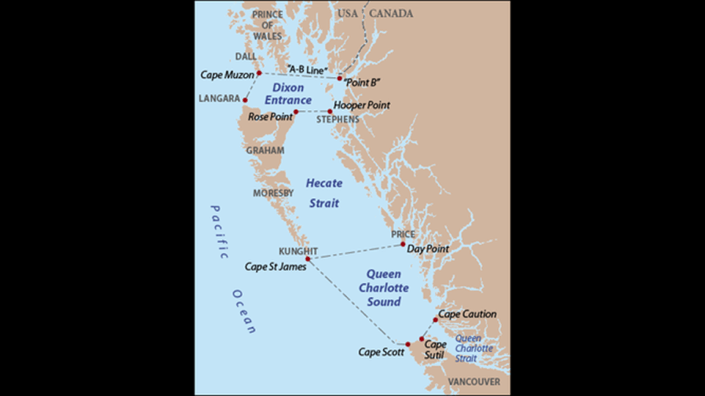
It lies between the Clarence Strait in the Alexander Archipelago, a 300-mile, or 480-kilometer, long group of islands in Alaska to the North…

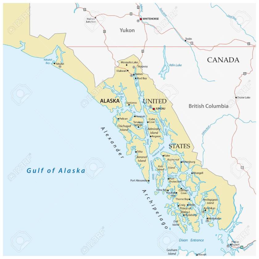
…and the Hecate Strait and the islands known as the Haida Gwaii (or Queen Charlotte Islands) in British Columbia to the South.

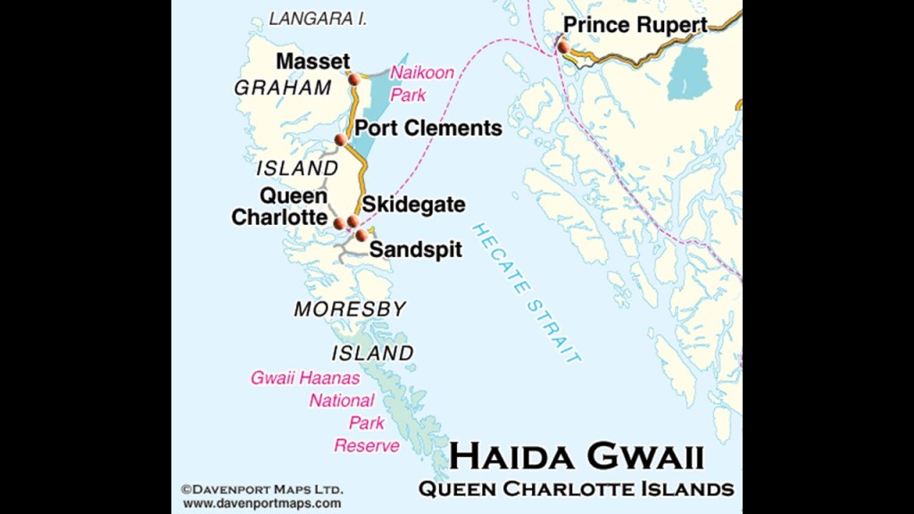
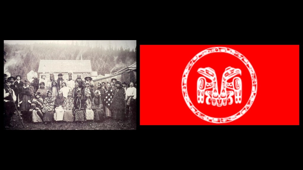
Members of the Haida Nation maintain free access across the strait, in the Haida Gwaii and islands in the Alaskan Panhandle where they have said to have lived for 14,000 years.

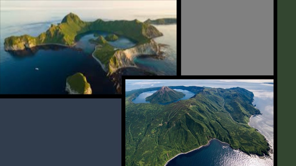
Next, the Kuril Islands dispute is a disagreement between Japan and Russia over the sovereignty of the four southernmost Kuril Islands.

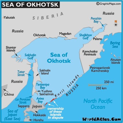
They are a chain of islands stretching between the Japanese Island of Hokkaido at the southern end, and the Kamchatka Peninsula at the northern end.

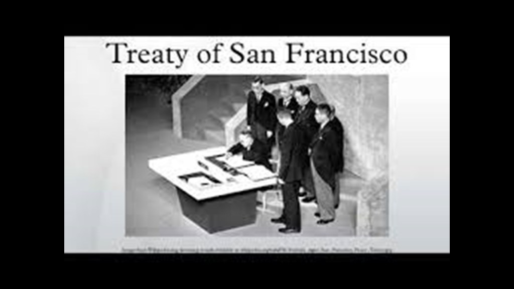
While the San Francisco Peace Treaty of 1951, signed between the Allies and Japan in 1951, stated that it must give up all right, title and claim to the Kuril Islands, Japan does not recognize Russia’s sovereignty over them, and this territorial dispute has not been resolved.

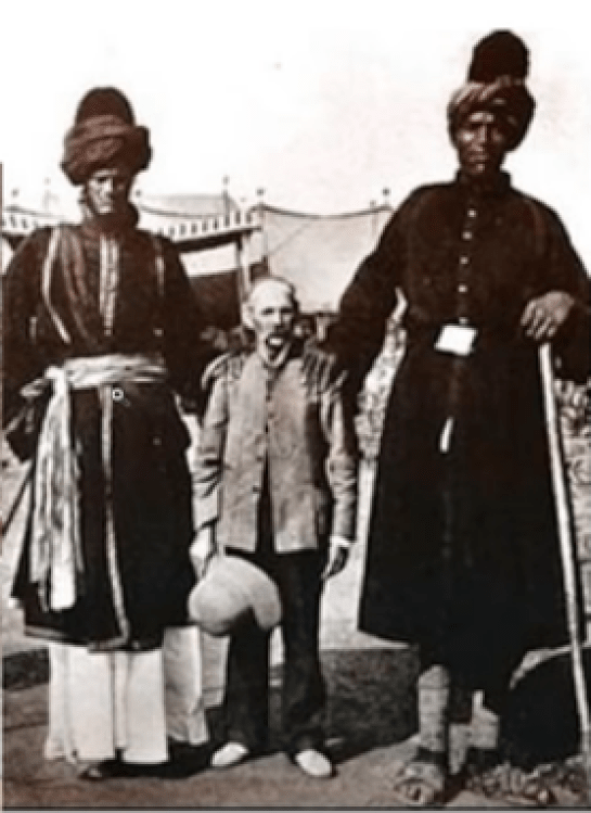
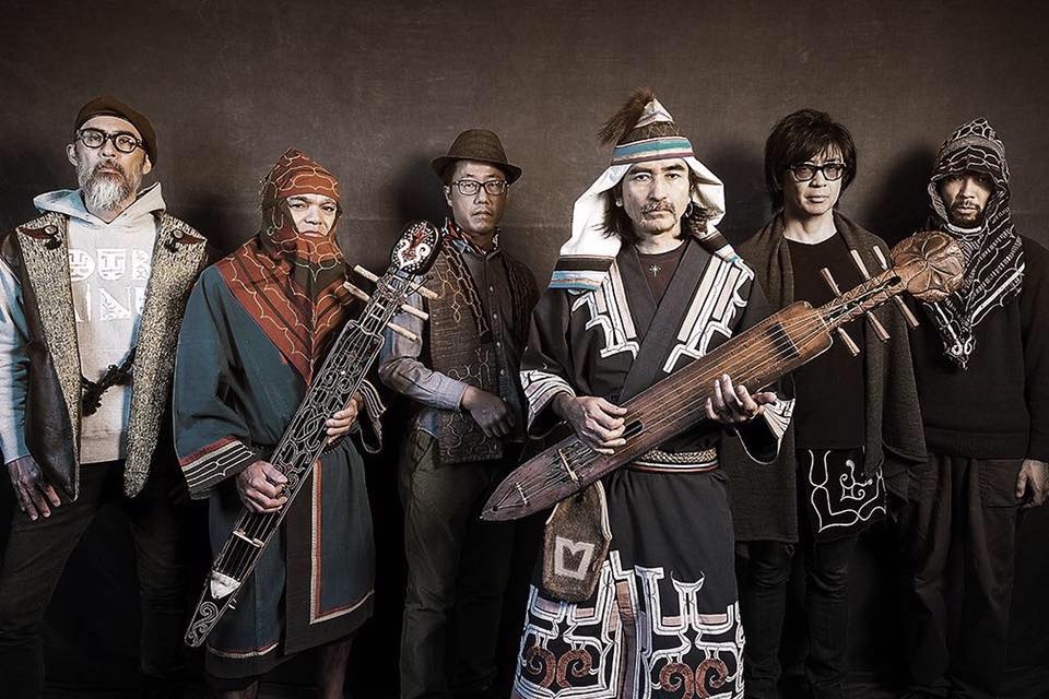
The original inhabitants of the Kuril Islands, and northern Japan for that matter, are the Ainu, as seen here in 1904…
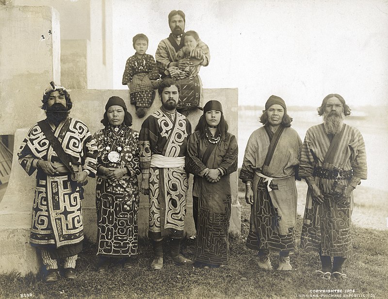
…and today.

Other disputed islands around the world include:

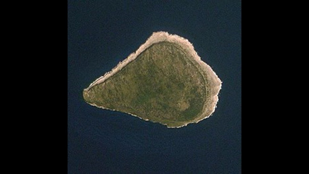
Navassa Island, an uninhabited island in the Caribbean Sea.

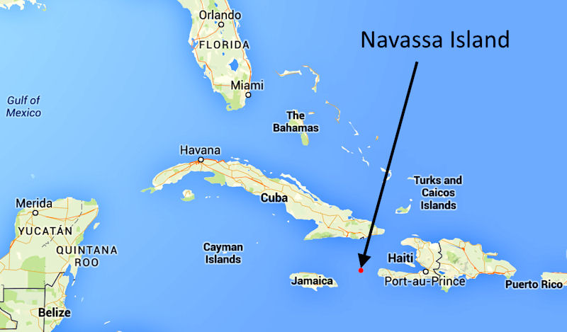
This small island is subject to an on-going territorial dispute between the United States and Haiti.

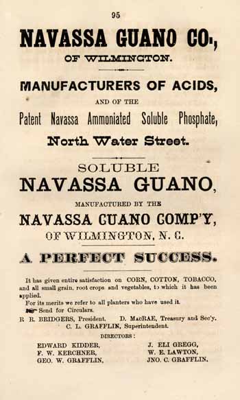
The United States claimed the island since 1857, based on the Guano Islands Act of 1856.

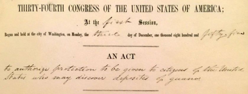
The legislation essentially said that an American could claim an uninhabited, unclaimed island, if it contained guano, or bird droppings, which was an effective early fertilizer.

Haiti’s claims over Navassa go back to the Treaty of Ryswick in 1697, which established French possessions in mainland Hispaniola that were transferred from Spain by the treaty.

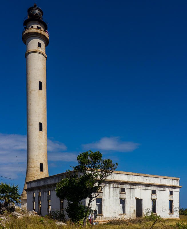
This is the deactivated lighthouse on Navassa. This is the only building left of what was previously on Navassa Island…

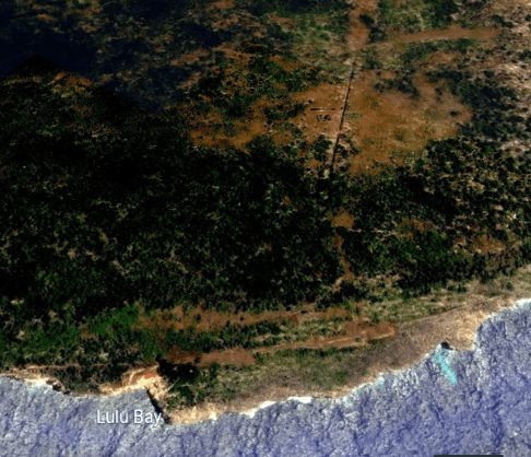
…possibly including this star fort identified as being in Lulu Town on Navassa, but I can’t confirm this finding because whatever was there isn’t there any more.

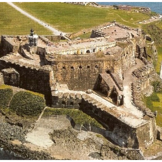
Lulu Town was previously situated around Lulu Bay on Navassa Island.

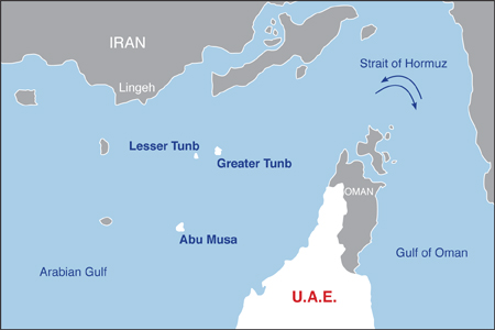
Abu Musa is a 5-square-mile, or 13-square-kilometer, island in the eastern Persian Gulf near the entrance to the Strait of Hormuz.

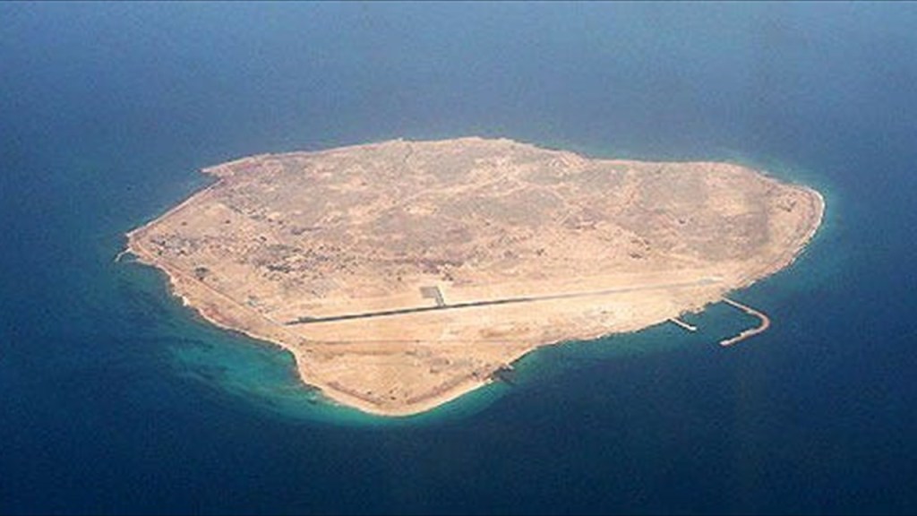
Abu Musa is administered by Iran as a part of its Hormozgan Province, but it is also claimed by the United Arab Emirates as a territory of the Emirate of Sharjah.

I found the island of Abu Musa, one of the islands of the Strait of Hormuz, when I was tracking the Amsterdam Island Circle Alignment.

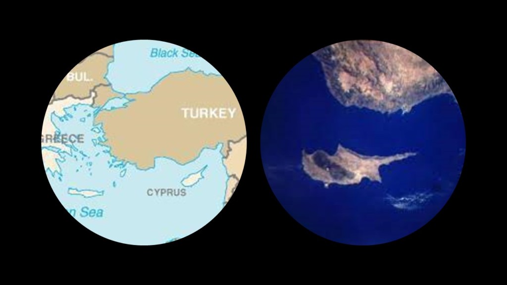
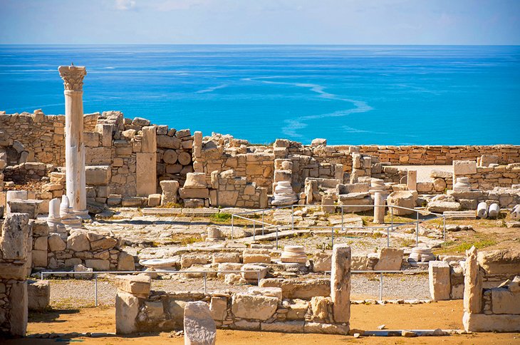
On to Cyprus, an island country in the eastern Mediterranean, located south of Turkey, and west of Syria and Lebanon, northwest of Israel and Palestine, north of Egypt, and southeast of Greece.

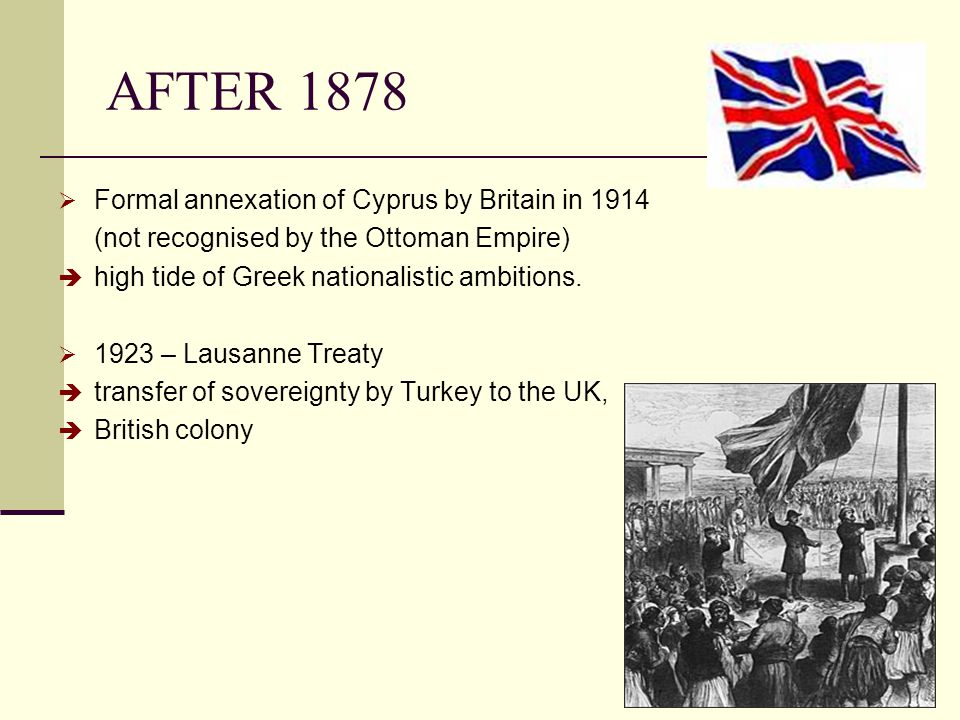
Based on the Cyprus Convention in 1878, Cyprus was placed under the United Kingdom’s administration, and formally annexed by the United Kingdom in 1914 (which would have been around the time of the start of World War 1).

While Turkish Cypriots made up 18% of the population, the partition of Cyprus and creation of a Turkish state in the north became a policy of Turkish Cypriot leaders and Turkey in the 1950s.

Turkish leaders for a period advocated the annexation of Cyprus to Turkey as Cyprus was considered an “extension of Anatolia” by them; while, since the 19th century, the majority population of Greeks on Cyprus and its Orthodox Church had been pursuing union with Greece, which became a Greek national policy in the 1950s.

After nationalist violence in the 1950s, Cyprus was granted independence in 1960 via the London and Zurich Agreements of 1959.

At any rate, conflict in one form or another between Greeks and Turks has existed on the island for awhile, with the island partitioned between the two.

Regardless, Cyprus is a major tourist destination in the Mediterranean today.

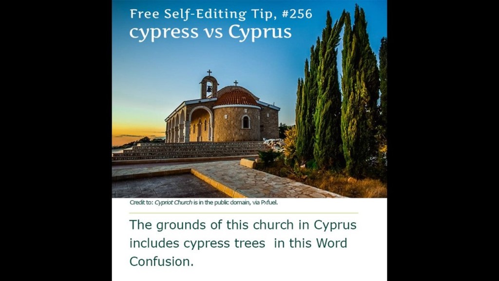
It’s important to note that the island of Cyprus shares the name of a tree, pronounced phonetically the same, though spelled differently.

So while we are told, no, they are not the same, there are in fact, cypress trees on Cyprus, and they are native to Cyprus.

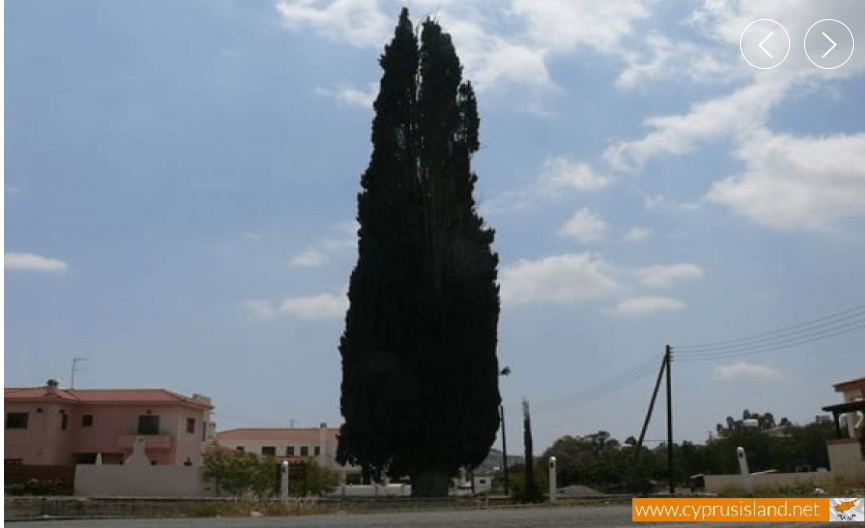
The “Frank Cypress” in Nisou, is said to be 500-years-old, in existence since the time of Frankish rule there, is one of the tallest cypress trees on the island today, at 28-meters-, or 92-feet, -tall, and 4.5-meters, or 15-feet, -wide.

Also important to note that Cypress wood was used in the building of Solomon’s Temple.

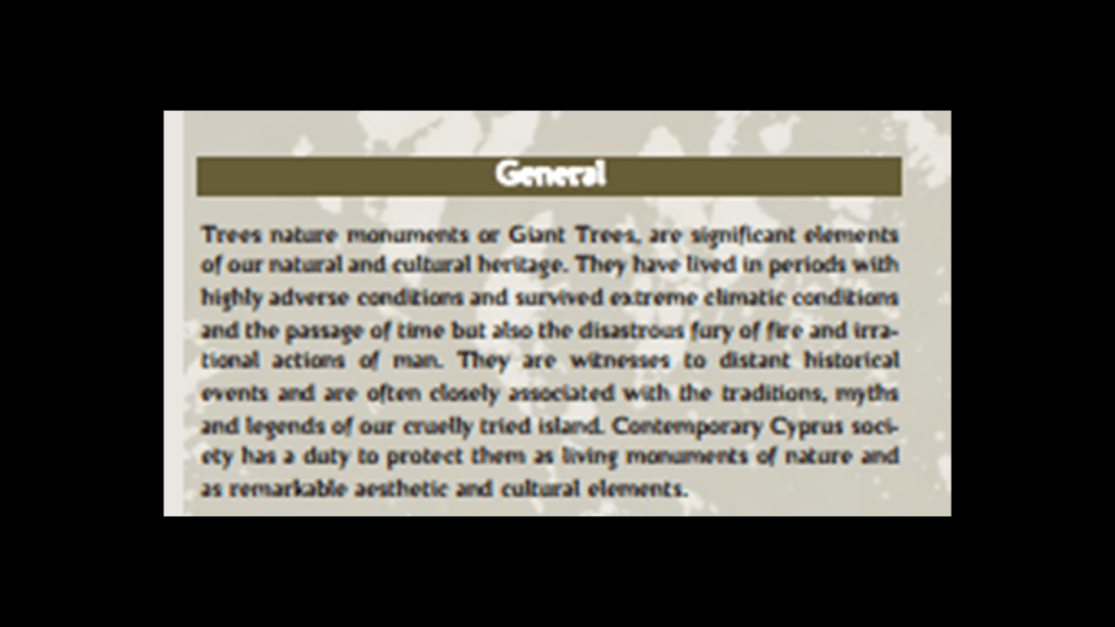
There seems to be a lot more to find here about ancient giant trees in general on Cyprus, but let’s just say they are revered here.

Just a couple of more places to look at.

Tromelin Island is a low, flat island in the Indian Ocean.

Besides being a seabird and sea tortoise sanctuary, the only structure here is a meteorological station used to gather data in order to forecast hurricanes and cyclones.

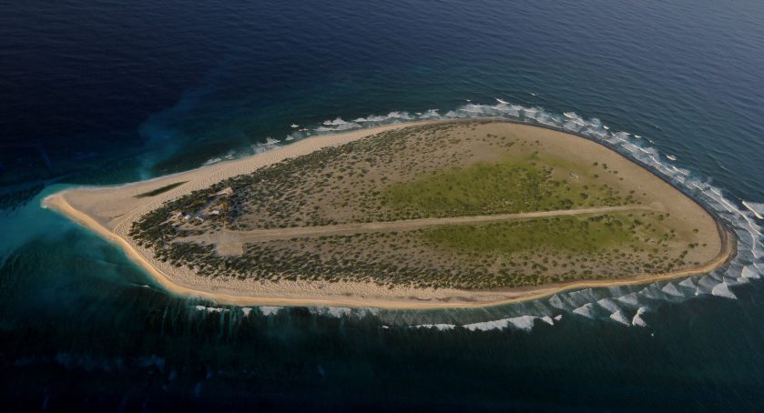
It is located 310-miles north, or 500-kilometers, north of Reunion Island, and 280-miles, or 450-kilometers, east of Madagascar.

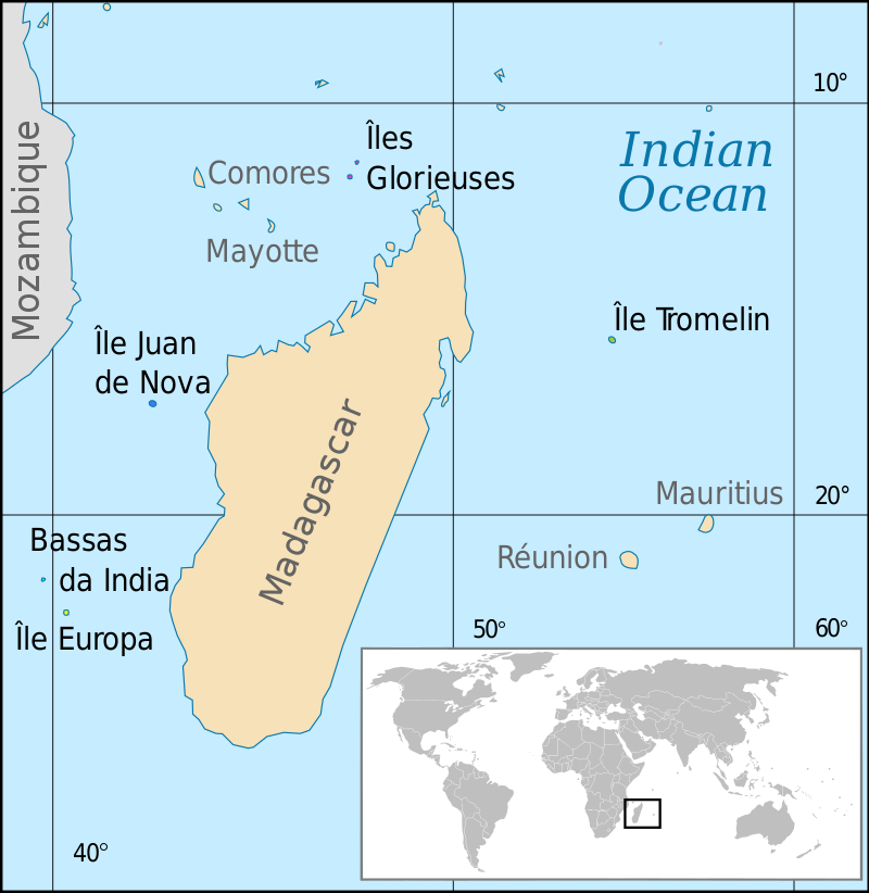
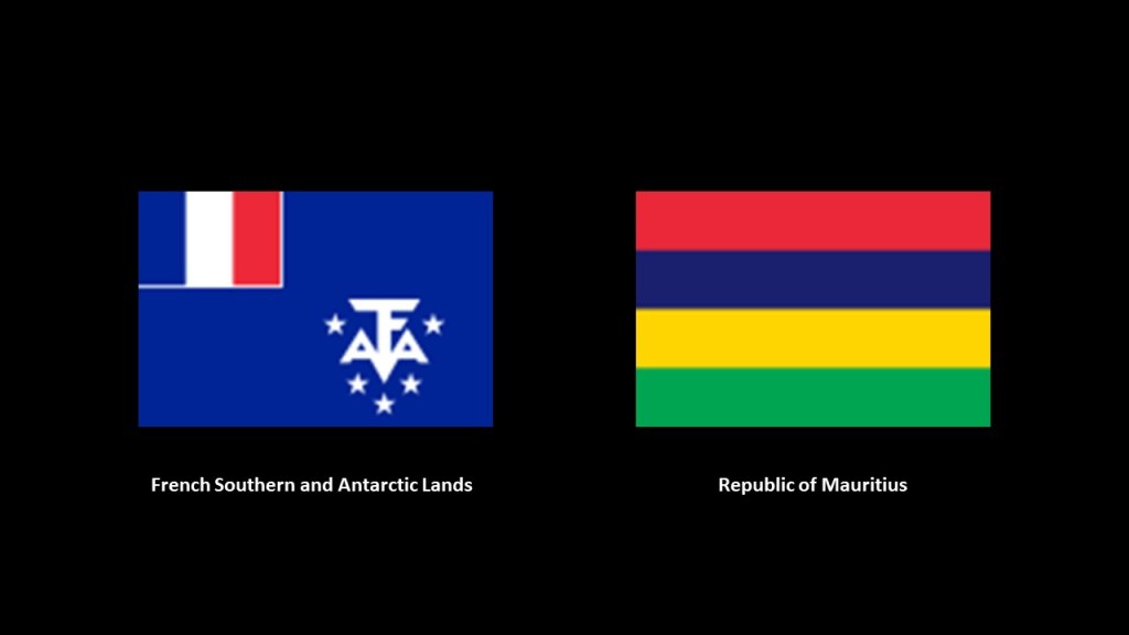
It is administered as part of the French Southern and Antarctic Lands as a French overseas territory, however, the island nation of Mauritius claims sovereignty over the island.

I found both Mauritius and Tromelin Island on earth-grid alignments.

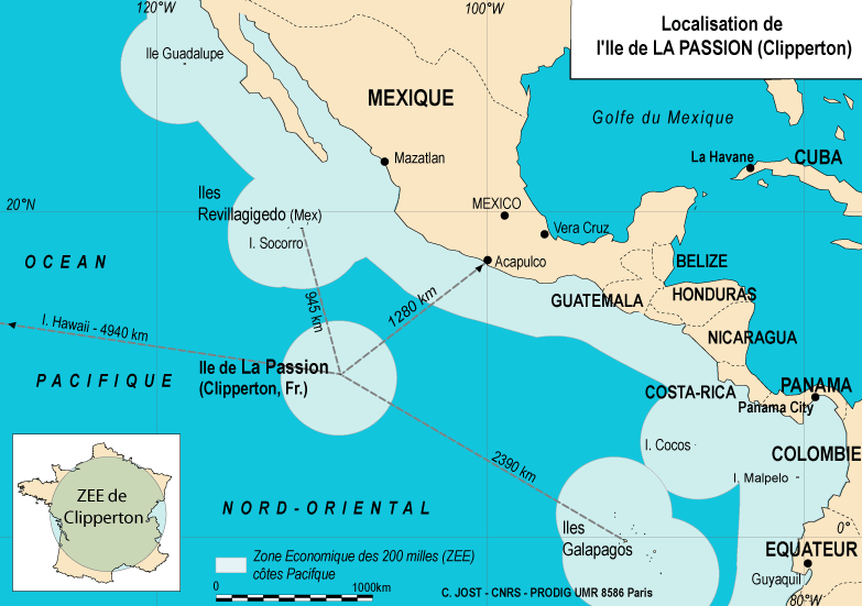
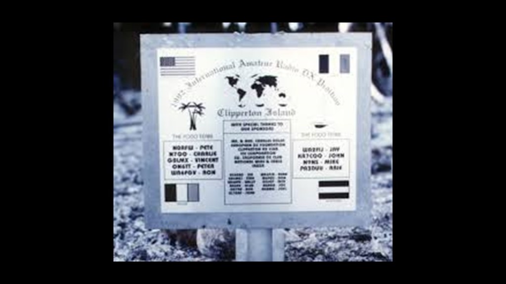
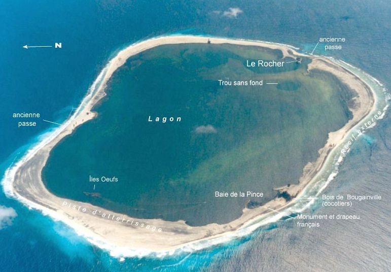
The last place I want to include in this post is Clipperton Island, an uninhabitated 2-square-mile, or 6 kilometer-squared island, in the eastern Pacific Ocean off the coast of Central America.

While it is not disputed now, it has been in the past.

It is an overseas minor territory of France, and administered under the direct authority of the Minister of Overseas France.

It has not been inhabited since 1945, though it is occasionally visited by fisherman, French Navy patrols, scientific researchers, film crews, and ham radio operators.

It is low-lying, and largely barren.

The surrounding reef is exposed at low tide.

Two Frenchmen first claimed the island for France in 1711, and named it “Ile de la Passion.”

In 1858, during France’s Second Empire, Emperor Napoleon III annexed Clipperton island as part of the French colony of Tahiti, even though it is the considerable distance of 3,400 miles, or 5,400 kilometers, from Tahiti.

It was named Clipperton for English pirate and privateer John Clipperton who fought for the Spanish in the early 18th-century who may have used it as a base for his raids on shipping.

Other claimants included the United States, whose American Guano Company claimed it, like Navassa Island, under the Guano Islands Act of 1856…

…and Mexico due to its activities there as early as 1848 and 1849.

It also has a lurid and bizarre history of its own from its days as part of Mexico.

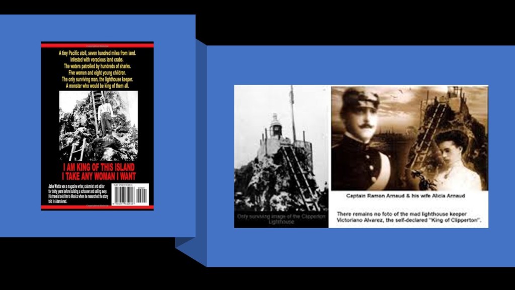
In 1909, France and Mexico agreed to submit the dispute over sovereignty to binding international arbitration, and 22-years later, in 1931, the King of Italy, Victor Emmanuel III, issued the final decision, declaring Clipperton Island to be a French possession.

However, after all of this territorial interest, Clipperton Island has been more or less abandoned since the end of World War II.

So, as expressed in the title of this post, there is something about the world’s disputed islands that make them desirable possessions worth fighting over.

As you can see from the locations mentioned in this post, these are mostly obscure, seemingly insignificant islands and island groups that are the subjects of territorial disputes between countries, most of which are still on-going in the present day.

There are many other examples of territorial disputes, but these are enough to give you the idea with regards to disputed islands.

I definitely think it’s significant that these little islands and island groups figure prominently on the Earth’s gridlines, and that there is much more to the story we are not being told, especially with regards to the once-existence of giant trees on Earth that were integral to the Earth’s grid system.

All of these islands are viewed as highly-coveted prizes, and as a critical part to nation-building plans.

The reason has been deliberately hidden from our view as to “What is it Exactly About the World’s Disputed Islands?”

A Quick Look at Three State Capitol Complexes in the United States

In the course of my research, I have had occasion to look into three State Capitol complexes – that of Harrisburg, Pennsylvania; Des Moines, Iowa; and Sacramento, California.

As we shall see, the locations chosen for modern seats of government would have been very special locations in the original advanced civilization of the Old World.

Before I begin, “Capitol,” spelled with an “o” is the building in which a legislature operates., and “Capital,” spelled with an “a” is the seat of government, of states, provinces, or countries.

First, Harrisburg, the State Capital of Pennsylvania.

Harrisburg is situated on the east bank of the Susquehanna River, only 107-miles, or 172-kilometers, west of Philadelphia.

CZ had sent me screenshots of the Capitol District in Harrisburg aawhile back that was the basis for the research I did there.

What we are told is the land that became Harrisburg had been purchased by an English trader named John Harris Sr. in 1719; John Harris Jr. made plans to lay-out a town on his father’s land; and the land was surveyed by William Maclay, John Harris Sr’s son-in-law.

The city of Harrisburg became incorporated in 1791; and named the Pennsylvania State Capital in October of 1812.

The current State Capitol Building was said to have been designed by architect Joel Miller Huston, and built between 1902 and 1906 in the Beaux-Arts style of architecture.

The interior of the Pennsylvania State Capitol is described as having decorative Renaissance themes throughout the building.

It is part of what is called the Pennsylvania State Capitol Complex.

On the East side of the Capitol building is what is referred to as the East Wing, described as a 1987 extension of the Capitol building.

Flanking the East Wing are the North and South Office buildings,

The North Office building was said to have been built in Indiana limestone starting in 1927…

…and the South Office building in Indiana limestone starting in 1919.

We are told the oldest building of the complex is the Ryan Office building, with a construction completion date of 1894.

East of the North and South Office buildings, across Commonwealth Avenue, there are a pair of buildings situated across from each other at either end of the “Soldiers’ and Sailors’ Memorial Grove.”

I will be touching more on the Soldiers’ and Sailors’ Memorial Bridge that you can see the pylons of in the background momentarily.

The Forum building is on the south-side of the Memorial Grove, was said to have been built out of grey limestone, and featuring 22 bronze doors, between 1929 and 1931 in the style of an open-air Greek amphitheater, complete with a star map of the night sky depicting the zodiac and other constellations with over 1,000 stars on the ceiling…

…and on the north-side of the Memorial Grove is the Pennsylvania Treasury Building, said to have been a project of the New Deal Era Public Works Administration during the Great Depression built between 1937 and 1940.

The eastern-most portion of the Pennsylvania State Capitol Complex is the “Soldiers’ and Sailors’ Memorial Bridge,”or the “State Street Bridge,” which connects the complex to neighborhoods across the railroad tracks that run east of North 7th Street.

It is a 1,312-foot, or 400-meter, deck-arch bridge said to have been constructed between 1925 and 1930.

The State Museum of Pennyslvania is directly adjacent to the Pennsylvania State Capitol Complex…

…run by the state through the Pennsylvania Historical and Museum Commission to “preserve and interpret the region’s history and culture,” and includes a multi-media planetarium, and four-floors of exhibits covering Pennsylvania history from prehistoric times through today.

CZ also sent me screenshots of the Scottish Rite Cathedral and Masonic Temple of Harrisburg…

…with a tall obelisk on its grounds.

The 1,192-seat Theater and Ballroom at the Scottish Rite Cathedral is a popular community event venue.

And this seems to be the extent of what I am able to find out about it!

Next, I am going to take a look at the State Capitol Complext at Des Moines, the capital city of Iowa.

The Iowa State Capitol Building was said to have been built between 1871 and 1886, and the only 5-domed capitol building in the United States.

The Iowa Statue of Liberty is located on the capitol grounds.

It is described as a replica of the Statue of Liberty that was a gift in 1950 from the Boy Scouts of America as part of their efforts to “strengthen the arm of liberty.”

Interesting thing is, there are hundreds of replicas of the Statue of Liberty, said to be a figure of Libertas, a Roman goddess and the personification of liberty, all over the Earth.

Are they replicas…or do they represent something else entirely?

The Bicentennial Fountain is on the west-side of the State Capitol Complex.

What we are told about the Bicentennial Fountain is that it was originally a replica of a fountain that was displayed at the 1876 Centennial Exposition in Philadelphia, and that after years of vandalism and disrepair, it was replaced by a new fountain in 1982.

So there’s another “replica of” to explain something’s existence.

Also in the Iowa State Capitol Complex, to the rear of the State Capitol Building, we find the Soldiers and Sailors Monument, an obelisk-looking monument, in direct alignment with the dome of the Capitol building, which we are told was erected to commemorate Iowans who fought during the Civil War.

The last place I want to look at in the Iowa State Capitol are the bridges over the Des Moines River on the west-side of the complex.

The East Locust Street Bridge is situated between the East Walnut Street Bridge and the Grand Avenue Bridge, and East Locust Street is in direct alignment with the Iowa State Capitol Building.

The other two bridges and streets go on either side of the complex.

Lastly, the California State Capitol complex in Sacramento.

The Tower Bridge crosses the Sacramento River, and leads right in to the Capitol Mall in front of the California State Capitol Building, in the same manner as the precisely laid-out bridges and streets connect to the State Capitol complexes in Harrisburg and Des Moines.

The California State Capital building was said to have been designed in the Neoclassical-style by Reuben S. Clark, and constructed between 1861 and 1874, which would have been completed three-years after the start date of the Iowa State Capitol building’s construction in 1871 according to the historical narrative we have been given.

The Tower Bridge is also a vertical-lift bridge, and connects Sacramento and West Sacramento across the Sacramento River.

We are told the construction of the Tower Bridge as a replacement bridge for the 1911 M Street bridge was said to have started in 1934 and first opened in 1935.

This would have been around the time of the Great Depression and the beginning of World War II.

The original 1911 bridge was described as a “swing-through truss railroad bridge” that was determined to be inadequate as the result of Sacramento’s population growth doubling between 1910 and 1935, and the city’s concern for needing a better crossing over the Sacramento River in case of war.

Alfred Eichler was credited as the architect of the Tower Bridge, and its architectural-style described as a rare use of “Streamline Moderne,” a style of “Art Deco” that emerged in the 1930s.

The two towers of the bridge alone are 160-feet, or 49-meters, -high.

It is located in “Old Sacramento,” the riverfront historic district, with Gold Rush-era buildings attributed to Victorian-era gold miners.

You can go on an “Underground Sacramento” Tour any day of the week, where you will learn how Sacramento lifted itself up out of floodwaters in the 1860s and 1870s by the “jacking” up of buildings to avoid further flooding.

The Tower Bridge is part of State Route 275 which connects West Capitol Avenue and the Tower Bridge Gateway with the Capitol Mall in Sacramento.

The Capitol Mall in Sacramento is described as a major street and landscaped parkway.

The former Drexel University Sacramento Center for Graduate Studies was in a building situated right next to the Tower Bridge at the address of 1 Capital Mall.

It opened in 2009, and started closing in 2015 to allow currently enrolled students to complete their studies.

It was then permanently closed.

There is a California State Government building called “The Ziggurat” in West Sacramento right next to the Tower Bridge.

The Ziggurat was said to have been designed to resemble ancient Mesopotamian ziggurats and built by The Money Store in 1997.

Since 2001, it has been leased to the state as the headquarters of the California Department of General Services.

The Ziggurat is illuminated at night on special occasions.

The Stanford Mansion is in the neighborhood of the Capital Mall, a couple of blocks south of the State Capitol Building and serves as the official reception center for the California government.

It was said to have been built in 1856 as a residence for Leland Stanford, a Railroad Baron who was a former California governor, and founder of Stanford University in 1885.

It was donated to the Roman Catholic Diocese of Sacramento in 1900, who operated a children’s home there until 1978.

The Cathedral of the Blessed Sacrament, the seat of the Roman Catholic Diocese of Sacramento, and is one of the largest cathedrals west of the Mississippi River.

It was said to have been built between 1887 and 1889 in the Italian Renaissance architectural-style on the outside, and the Victorian architectural-style on the inside.

The cathedral’s designer was said to be Patrick Manogue, a former gold-miner who came to Sacramento through the California Gold Rush, who became a Catholic priest in 1861 after studying in Paris, and then the Bishop of Sacramento in 1886.

He was said to have based the design of his cathedral on a church he was inspired by in Paris, and that it was built on land donated by the State’s first elected governor, Peter Burnett.

The Capitol Park in Sacramento covers 40-acres, or 16-hectares, and I will cover a few examples of what is found on the grounds.

The California State World Peace Rose Garden occupies roughly 5-acres, or 2-hectares of the area it covers, featuring 650 roses with different colors and fragrances.

The Civil War Memorial Grove on the Capitol State Park Grounds was said to have been planted in 1897 with saplings from famous Civil War battlefields, like Manassas, Virginia; Harper’s Ferry, West Virginia; and Vicksburg, Mississippi.

You know, it’s interesting, that we don’t even notice the straight-edges of megalithic stone blocks all around us that get used, like in this case, as a place to put signage.

Instead, a label like “boulder” is put on huge cut-and-shaped stones like this and which covers it up nicely as not being something out-of-the-ordinary that we should be paying attention to.

And the California Veterans’ Memorial on the Capitol State Park grounds is an 30-foot, or 9-meter tall, black-granite obelisk that was dedicated in 1998 to California’s veterans who had served in the Armed Forces since statehood in 1850.

These are just a few of the memorials and monuments to be found on the grounds of the park.

This is just a sample of countless examples of the shared characteristics of Capitol building complexes, and a few other locations nearby as well.

A sample is all that is needed to illustrate that they are all have similar characteristics of mind-blowing examples of monumental architecture and precise civil-engineering feats that do not match what we are supposed to have been capable of in our historical narrative, which would have been very low technology in the 19th-century and early 20th-century according to what we have been taught to believe.

The stories we are told don’t match the grandeur of the architecture and the incredible feats of engineering that we see in these places, and I would surmise the same is true of capitals the world over.

Things to consider in regards to how this ancient, advanced worldwide Moorish civilization has been hidden right in front in front of our eyes by those who have sought to keep our True History from our Awareness.

Snapshots from the National Statuary Hall – Frances Willard and Maria Sanford

I have been working my way through who is represented in the National Statuary Hall at the U. S. Capitol Building in Washington, DC.

There are two statues representing each state, and I am currently about half-way through the 50-states.

As a way to highlight what I am finding out in the process of doing this research, I am bringing forward unlikely pairs of historical figures represented in the Statuary Hall who have things in common with each other in this separate series called “Snapshots from the National Statuary Hall,” and in this post I am pairing two ladies, Frances Willard and Maria Sanford.

The only reason my attention was drawn here in the first place was because I encountered two historical figures in other research who are represented in the National Statuary Hall – Father Eusebio Kino, a Jesuit Missionary and Cattle rancher, for Arizona, and Mother Joseph Pariseau, a Catholic sister and self-taught architect, for Washington State.

Seeing these two little-known, and on the unusual-side, historical figures represented there got me to wondering who else was chosen by their State to be represented there and what else could possibly be going on here.

Not only am I finding much in common between the pairs featured in each of the nine- installments of the “Snaptshots of the Statuary Hall” series, I am finding, regardless of fame or obscurity, that the National Statuary Hall functions more-or-less as a “Who’s Who” for the New World Order and its Agenda.

I have paired people like Michigan’s Gerald Ford, a former President of the United States, and Mississippi’s Jefferson Davis, the former President of the Confederate States of America, and both men featured on the cover of the “Knight Templar” Magazine; Dr. Norman Borlaug, Ph.D, often called the “Father of the Green Revolution; and Colorado’s Dr. Florence R. Sabin, M.D, a pioneer for women in science, both of whom worked for the Rockefeller Foundations; and Louisiana’s controversial Socialist Governor, Huey P. Long, and Alabama’s Helen Keller, a deaf-blind woman who gained prominence as an author, lecturer, Socialist activist.

As I mentioned, I am pairing two ladies in this post.

Frances Willard represents the State of llinois, and Maria Sanford represents Minnesota.

First, Frances Willard.

Frances Willard was an American educator, temperance reformer, and women’s suffragist.

Frances was born in 1839 in Churchville, New York, near Rochester, to Josiah Flint Willard, a farmer, naturalist, legislator & businessman, and Mary Willard.

The family moved to Oberlin, Ohio, in 1841, where her parents took classes at Oberlin College.

Oberlin College was established in 1833, and is the oldest coeducational liberal arts college in the United States, and the second-oldest in the world.

Then in 1846, the family moved to Janesville, Wisconsin, for the given reason of her father Josiah’s health.

There, Frances and her sister Mary were said to have attended the Milwaukee Normal School, where their mother’s sister taught.

The Willard Family moved to Evanston, Illinois, in 1858, where Josiah Willard became a banker.

Frances and her sister Mary attended the North Western Female College there.

Their brother Oliver attended seminary at the Garrett Biblical Institute in Evanston.

After Frances Willard graduated from the North Western Female College, she worked at the Pittsburgh Female College…

…and also at the Genessee Wesleyan Seminary in New York, which later became Syracuse University.

Then in 1871, she was appointed as President of the newly-founded Evanston College for Ladies.

In 1873, she was named as the first Dean of Women when the same school became the Woman’s College of Northwestern University.

This position didn’t last long for her over confrontations in 1874 with the University’ President, Charles Henry Fowler, who had been her fiance.

After this happened, she focused her career energies into the Women’s Temperance Movement, and she was involved in the founding of the Women’s Christian Temperance Union (WCTU), also in 1874, and was elected the first Corresponding Secretary.

The WCTU was among the first organizations of women devoted to social reform, playing an influential role in the Temperance Movement, supporting the 18th Amendment to the Constitution that established Prohibition, and influential in other social reform issues of the Progressive Era.

She was elected President of the National WCTU in 1879, and held this post until her death in 1898.

Frances Willard was also editor of the organization’s weekly newspaper, “The Union Signal” from 1892 to 1898.

Willard argued for the right for women to vote, based on “Home Protection,” as President of the WCTU, as a part of which she argued that having the right to vote gave women a means of protection in and outside of the home against violent acts caused by intoxicated men.

Frances Willard founded the World WCTU in 1888 and became its first President in 1893.

After 1893, Willard became a committed Christian Socialist, having been influenced by the Fabian Society in Great Britain.

The Fabian Society was a British Socialist organization whose purpose was to advance the principles of Democratic Socialism rather than by revolutionary overthrow.

Christian Socialism was established as a religious and social philosophy that blended Christianity and socialism, advocating for left-wing politics and socialist economics from a Biblical perspective.

Frances Willard died in her sleep from influenza on February 17th of 1898 where she was staying at the Empire Hotel in New York City just prior to leaving for a European tour…

…and was buried in the Rose Hill Cemetery in Chicago, Illinois.

She bequeathed her home in Evanston to the WCTU, and it became her museum and the headquarters for the organization in 1900.

There are a couple things that stand out for me in Frances Willard’s life story.

One is her affiliation with something called “Christian Socialism,” which apparently was based on an organization that was modelled after a British Socialist organization whose stated purpose was to advance the principles of Democratic Socialism rather than by revolutionary overthrow.

So, it sounds like they were finding another way to advance the cause of socialism and communism around the world through the establishment of democratically-run socialist governments, versus by means of the violent overthrow of an existing government.

In other words, they decided to achieve the same outcome of overthrowing the existing government and economic system by vastly different means from straight-out revolutionary overthrow.

Another thing that I would like to point out is that I find the whole Temperance Movement to be extremely interesting from a social stand-point of those times

On the one hand, the Temperance Movement was called a social movement against the consumption of alcohol, and typically criticized alcohol consumption and emphasized alcohol’s negative effects on people’s health, personalities, and lives, and demanded the complete prohibition of it.

Notice how similar the Temperance Movement cartoon entitled “The Drunkard’s Progress” is on the left to the illustration of “The Steps of Masonry” on the right.

On the other hand, the alcoholic beverage industry was becoming well- established during this time period between 1830 and 1900, creating the juxtaposition of a culture that encouraged the profuse consumption of alcohol, and at the same time there was a counterforce within that same culture that not only criticized alcohol consumption, but that got involved in “charitable institutions” with stated missions of guiding the poor out of the impoverishment and crime coming from the problem of drinking too much alcohol.

There has been an abundant supply of beer and hard liquor, starting at least as early as the late 18th-century, with people like John Molson in Montreal, whose business quickly grew into one of the larger ones in Lower Canada between 1788 and 1800, having sold 30,000 gallons, or 113,500-liters, of beer by 1791.

John Molson was also appointed the Provincial Grand Master of the District Freemasonic Lodge of Montreal by the Duke of Sussex in 1826, a position he held for five years before resigning in 1831.

Here is one of countless examples of the ubiquitous brewing business in Jamaica Plain in Boston alone.

Jamaica Plain was the home to most of Boston’s thirty-one breweries prior to the outlawing of alcoholic beverages during the Prohibition Era starting in 1920.

The reasons given for the high number of breweries were: 1) the quality of the water from the local aquifer; 2) the cheap cost of land in the area after merging with Boston in 1868; and 3) the influx of German and Irish immigrants here with a taste for lager and ale.

Yet, invariably the drinking problems have always been squarely placed on individuals and their addictions, instead of the never-ending supply produced by the alcoholic beverage industry.

Heck, even “Alcoholics Anonymous” has a step reference, like “The Drunkard’s Progress” and “The Steps of Masonry,” with its “Twelve-Step Program.”

Next, I am going to take a look at Maria Sanford.

She represents Minnesota in the National Statuary Hall.

Maria Sanford was an American educator, and one of the first female professors in the United States.

Maria Sanford was born in Saybrook, Connecticut, in December of 1836.

Old Saybrook is located where the Connecticut River meets Long Island Sound.

She received her education from the New Britain Normal School, the first training school for teachers in Connecticut, and the sixth in the United States.

Today it is Central Connecticut State University.

After graduating from the New Britain Normal School with honors in 1855, she taught in various schools around Connecticut for the next twelve years.

She moved to Pennsylvania in 1867, and became a principal and superintendent of schools in Chester County.

Known as an innovator, she conducted regular meetings of teachers and demonstrated new teaching methods.

She became a Professor of History and English at Swarthmore College in Pennsylvania from 1871 to 1880.

Swarthmore College was founded by Quakers in 1864, which would have been one year before the end of the American Civil War, and the first classes offered in 1869.

Sanford was invited to become a Professor at the University of Minnesota by its President, Dr. William Watts Folwell, and she joined the faculty there in 1880 as a Professor of Rhetoric and Elocution, where she also lectured in literature and art history, a position she held until her retirement in 1909.

She was a leading voice outside of academia.

Among other things, she was an advocate for the conservation and beautification of Minnesota for the cause of the Chippewa National Forest from within the Minnesota Federation of Women’s Clubs, along with fellow clubwoman and forest conservationist Florence Bramhall…

Sanford reached out to her community and to the nation with the power of her speeches, travelling throughout the United States delivering more than 1,000 patriotic speeches.

In 1917, she delivered a speech, along with the Mayor of Minneapolis at the time Thomas Van Lear, on good government and women’s suffrage.

She delivered her most famous speech to the Daughters of the American Revolution Convention in April of 1920, entitled “An Apostrophe to the Flag.”

But not only did she give speeches, she took on a highly active role in the public sector, including, but not limited to, becoming the head director of Northwestern Hospital and serving as president of the Minneapolis Improvement League.

The University of Minnesota was said to have constructed Sanford Hall as a women’s dormitory in 1910 in honor of Maria Sanford.

Maria Sanford died on April 21st of 1920 in Washington, DC, and was buried in Philadelphia’s Mount Vernon Cemetery.

We are told that for months after Sanford’s death, she was so beloved in Minnesota that gatherings in her memory were held at the University of Minnesota and her home church Como Congregational.

As mentioned at the beginning of this post, I am bringing forward unlikely pairs of historical figures who are represented in the National Statuary Hall who have things in common with each other.

For one, both women were very well-educated for their day, with both receiving an advanced education, with Frances Willard attending the Milwaukee Normal School & the North Western Female College, and Maria Sanford attending New Britain Normal School, the first training school for teachers in Connecticut.

Both women went into the field of Higher Education, with Frances Willard becoming involved in College Administration at the Evanston College for Ladies, which later became the Women’s College of Northwestern University; and Maria Sanford teaching at the college -level at both Swarthmore College in Pennyslvania and the University of Minnesota.

Just want to make note of the beautiful Old World architecture seen at all the schools these ladies were connected with.

And both women became leading voices outside of academia, with Frances Willard eventually becoming an International leader in the Women’s Christian Temperance Union (WCTU) in 1893, the same year she became a committed Christian Socialist; and Maria Sanford took on the causes of things like state conservation issues, and went on to become a nationally-known speaker praised for her powerful speeches.

These two women apparently were well-known influencers of their time in key areas involving women, social issues and politics.

But they both definitely fall in the category of obscure historical figures.

I myself would never had heard of them had I not been nosing around the National Statuary Hall.

I am going to just keep putting out there what I am finding in the National Statuary Hall at the U. S. Capitol building in Washington, DC, where in many cases, obscure historical figures like these two ladies were honored, but with their lives and times telling a different kind of story than what we normally hear about.

The Historic Trolley Amusement Parks of Coney Island & the Reset of History

I am going to focus primarily on the historic trolley amusement parks of Brooklyn’s Coney Island in this post because there’s quite a bit of hidden history related to the historical reset to be found in this location.

This represents just a small fraction of the historic trolley parks, star forts and lighthouses once found in the Upper and Lower New York Bays and the Hudson River Valley, which I detailed in a previous post called “Star Forts, Gone-Bye Trolley Parks, and Light Houses of New York’s Hudson River Valley & New York Bays.”

Just in the distance ALONE between the entrance to the lower New York Bay at the Atlantic Ocean to the locations around the George Washington Bridge, I found: eleven star forts that are in pairs and/or clusters; five major historic trolley amusement parks; and eleven lighthouses.

There were three historic trolley amusement parks on Coney Island in the New York City Borough of Brooklyn, located right next to each other – Steeplechase Park, Luna Park and Dreamland.

For informational purposes, the other two of the five historic trolley amusement parks in the Upper New York Bay were Palisades Park near Fort Lee, New Jersey, on the Hudson River, and Fort George in Upper Manhattan on the Harlem River.

This is what we are told about the historic trolley amusement parks of Brooklyn’s Coney Island.

First, Steeplechase Park.

We are told that Steeplechase Park was created by entrepreneur George Tilyou in 1897.

He bought and improved the Steeplechase Horses attraction, which featured mechanical horses pulled along metal tracks.

The owner George Tilyou adopted a “Funny Face” mascot depicting a smiling man with several dozen teeth, nicknamed “the Tilly,” as the icon for his park.

The entrance to Steeplechase Park had a grand archway, on top of which were the statues of four horses.

Interestingly, the famous Brandenburg Gate in Berlin was also topped by four-horses.

Hmmm.

The Brandenburg Gate was said to have been designed by Carl Gotthard Langhans the Elder, who was inspired by the Propylaea of the Acropolis in Athens, and built between 1788 and 1791.

Carl Gotthard Langhans comes down to us in the historical narrative as a Prussian Master Builder and Royal architect in the Neoclassical-style, who was actually not trained as an architect, but instead educated primarily as a lawyer and mathematician.

His best-known work was said to be the Brandenburg Gate, but he was also credited with many churches, palaces, grand houses, interiors, city gates, and theaters.

We are told Carl Gotthard Langhans gained his architectural prowess from studying things like the ancient texts of the Roman architect Vitruvius.

Back to Steeplechase Park on Coney Island.

The park included at one time over 50 attractions on its midway alone…

…and Tilyou was said to have been inspired to build a Ferris Wheel after having seen the one at the 1893 Chicago World’s Fair on his honeymoon.

Other early noteworthy Steeplechase Park rides included the revolving Airship Tower, pictured here circa 1905…

…boats powered by naphtha, a liquid petroleum-product used as a fuel, cruising the “Canals of Venice,” a ride which he had removed sometime between 1905 and 1907…

…and the “Human Roulette Wheel,” which featured a giant , polished spinning disc that riders would sit in the middle of and slam into each other as it spun faster-and-faster.

In Steeplechase Park’s history, from its opening in 1897 and its closing in 1964, there were things like fires, rebuilding, rides added, and so on.

Like, for example, the 1907 fire.

This quick-spreading fire was alleged to ahve started from a carelessly-thrown, still-lit cigarrette into a garbage can at the “Cave of the Winds” attraction, and was finally extinguished two-hours later after having destroyed nearly everything within Steeplechase Park.

Remarkably, George Tilyou’s home at the corner of Steeplechase Park was spared due to the extra effort of fire-fighters on the scene.

Undaunted, George Tilyou vowed to rebuild Steeplechase Park, and to raise the funds needed to do this, sold 400,000 shares at $5-each, and threw in a season pass for each purchaser on top of that!

We are told the park partially reopened in April of 1908, and the reconstruction was said to be finished by 1909.

Here is a 1912 photo of Steeplechase Park, with the swimming pool front-and-center.

George Tilyou died in 1914, and Steeplechase Park remained in the Tilyou family until its closure in 1964, and over the years started to go into decline at different times for different reasons, but especially so with the onset of the Great Depression, which started in 1929 and resulted in a significant decline in park attendance.

The land of the former amusement park today is Maimonades Park, the location of a minor league baseball stadium.

The only remaining structure from Steeplechase Park is the defunct, but brightly-lit-up at night even today, Parachute Jump.

Next, I am going to take a look at Luna Park.

Luna Park at Coney Island opened in 1903.

It was said to have replaced Sea Lion Park that was operated by a man named Paul Boyton between 1895 and 1902, the first enclosed and permanent amusement park in North America.

Boyton was credited with being the first person to charge an admission fee to a large enclosed area containing multiple amusement rides and activities.

The so-named Captain Paul Boyton was a world-famous back-in-the-day aquatic daredevil and showman who travelled the world’s rivers in an inflatable rubber suit for “P. T. Barnum & Company’s Greatest Show on Earth & the Great London Circus.”

Here are some noteworthy historical side-notes about P. T. Barnum.

He was an early showman, businessman, and politician.

P. T. Barnum got his start in what is now the Financial District of Manhattan in 1841, with “Barnum’s American Museum,” which was known for its strange attractions and performances.

The attractions were a combination of zoo, museum, lecture hall, wax museum, theater, and freak show.

Apparently it became a central location in the development of American popular culture.

Barnum’s American Museum was filled with things like dioramas; scientific instruments; modern appliances; a flea circus; the “feejee” mermaid; Siamese twins, and other human curiosities.

The same “Feejee Mermaid” is still on display today at Harvard’s Peabody Museum.

On July 13th of 1865, the building which housed Barnum’s American Museum caught fire and burned to the ground.

Apparently there were not any human deaths, but a number of the live animal exhibits, including two whales imported from the coast of Labrador, were burned alive.

This was the second of five major fires connected to P. T. Barnum.

The first major fire associated with P. T. Barnum was the mansion he was said to have had built as his residence in Bridgeport, Connecticut, in 1848, and named “Iranistan.”

It was said to have been set on fire by workmen in 1857 when Barnum had been away for several months.

We are told Barnum had hired architect Leopold Eidlitz to design Iranistan as his own version of the Royal Pavilion in Brighton, said to have been constructed in England between 1787 and 1815.

The Royal Pavilion in Brighton was said to have been designed in the architectural-style of “Indo-Saracenic Revival,” as a seaside resort for the Prince Regent George, by British architect John Nash, who was called one of the foremost architects of the neoclassical-style of the “Georgian” and “Regency” eras.

The Flip Flap Railroad mentioned at the bottom of this image of Paul Boyton’s Sea Lion Park…

…was said to be the first looping roller coaster, on the left, and another historic Flip-Flap ride that comes to mind was the one at White City in London in what was called the Elite Gardens at the 1908 Franco-British Exhibition, on the right.

John Belcher was credited with the design of buildings here as the Chief Architect of the 1908 Franco-British Exhibition .

He was an English architect and President of the royal Institute of British Architects.

Paul Boyton’s remaining long-term lease on Coney Island’s Sea Lion Park was bought out starting on October 1st of 1902 by Frederic Thompson and Elmer “Skip” Dundy.

Thompson and Dundy were invited to the Steeplechase Park by George Tilyou for the 1902 Season.

They were known for their ride called “A Trip to the Moon” that was at the 1901 Pan-American Exposition that was held in Buffalo, New York.

The name of the fanciful airship that was the main part of the “A Trip to the Moon” ride was “Luna,” the Latin word for “moon’ for which, we are told, Luna Park in Coney Island was built around.

Well, for one thing, the problem with that story is that there were, and still are, Luna Amusement Parks all over the world, including, but not limited to, Mashhad, Iran, and Ankara, Turkey.

The land Luna Park was on was located next to where the Elephantine Colossus Hotel had been located.

We are told this hotel was a tourist attraction on Coney Island that was an example of novelty architecture, designed by Irish-American inventor James V. Lafferty.

The massive elephantine structure stood above Surf Avenue and West 12th Street from 1885 to 1896, at which time it burned down, giving Thompson and Dundy more land upon which to build Luna Park.

Speaking of elephants, this picture was taken in January of 1903, when Luna Park was said to have been under construction.

It shows Topsy the Elephant before she was executed by electrocution for being a “bad” elephant by Thompson and Dundy as a publicity stunt to advertise the opening of their new park. 

This seems hauntingly reminiscent of the building fire associated with showman P. T. Barnum that resulted in the tragic deaths of the large, helpless whales, and other animals, trapped inside.

The invited press that day included the Edison Movie Manufacturing Company, who filmed the event.

It was released to be viewed in coin-operated kinetoscopes under the title of “Electrocuting an Elephant.”

We are told the Luna Park’s architectural style was an oriental theme, with over 1,000 red and white painted spires, minarets, and domes on buildings constructed on a grand scale.

All the domes, spires, and towers were lit-up at night with several 100,000 incandescent lights.

In the middle of the lake at the center of the park was a 200-foot, or 61-meter, tall Electric Tower that was decorated with 20,000 incandescent lamps, said to be a smaller version of the Electric Tower featured in the 1901 Pan American Exposition in Buffalo.

Luna Park was accessible from Culver Depot, the terminals of the West End and Sea Beach Streetcar and Railroad lines.

Besides a multitude of rides, attractions at Luna Park included infant incubators, described as a new type of infant care where infant incubators containing premature babies were displayed in shows called “Infantoriums.

They were touted as “neonatal healthcare,” helping newborn babies with compromised immune systems by providing a sanitary environment to reduce the possibility of getting an infection.

infant incubators for premature babies became widely available at fairs and amusement parks across America, rather than hospitals, which we are told, had nothing to help them.

What we are told is that many parents of premature, at-risk babies pretty much had to bring their infants to a side-show infantorium at an amusement park or fair, and that these infant shows were the main source of healthcare for premature babies for over forty years. 

Say what??!!

Over the years, Luna Park would continue under different management, with constant changes.

The end of Luna Park came with two fires in 1944, one in August and one in October, which destroyed the park, and in 1946, the whole park was demolished.

There has been a Luna Park operating near the original location since 2010 that has no connection to the 1903 park.

Dreamland was the third and last of the three original parks said to have been built on Coney Island in the early 19th-century.

Dreamland was said to have been founded by successful Brooklyn real estate developer and former State Senator William H. Reynolds as a refined and elegant competitor to the chaotic noise of Luna Park, and opened in May of 1904.

The location of Dreamland was near the West Eighth Street subway station opposite Culver Depot.

Everything at Dreamland was touted to be bigger than Luna Park, including the larger Electric Tower, and four times as many incandescent lights than Luna Park.

Besides having high-class entertainment, morality plays, and rides, Dreamland had human zoos featuring dwarf inhabitants in what was called “Midget City…”

…a Somali Village…

…and a Filipino Village.

And, like Luna Park, Dreamland also had an infant incubator sideshow attraction.

It was typical for these historic permanent amusement parks and temporary exhibitions like World Fairs to have these infantoriums and human zoos as visitor attractions. 

So, as we saw with callous disregard for the lives of the animals in their care, these showmen and entrepreneurs had no regard for the sanctity and dignity of Human life either, except for how it benefited them.  A famous saying attributed to P. T. Barnum was “There’s a sucker born every minute!”

Another thing to mention is this, especially with respect to the existence of Human zoos during this time.

Exposition, the name frequently given to these large public exhibits, is a device used to give background information to the audience about the setting and characters of the story.

Exposition is used in television programs, movies, literature, plays and even music.

They were telling the general public the hunter-gatherer, or even head-hunter, narrative through these large expositions and exhibitions that they wanted people to believe and remember about these original people of the world, and not what they actually were as the builders of the original civilization.

Instead, they took credit for their accomplishments and legacy, and kicked the original advanced humans back to the Stone Age by their systemic practices of brutality, inhumane treatment, and marginalization, among many other things including large-scale genocide.

Dreamland’s life on Coney Island was ended only 7-years after opening.

On May 27th of 1911, a fire started at the Hell Gate attraction the night before the season’s opening day, and spread quickly, completely destroying the park by morning.

Brighton Beach is adjacent to the three major historic Coney Island amusement park locations, and shares the same name with the location of the Royal Pavilion of Brighton mentioned previously in this post. If there was an actual connection between these two places in the original civilization, it is long-lost.

The Brighton Beach Race Course was an American thoroughbred horseracing facility shown here opened on June 28th of 1879.

It was instantly successful and drew wealthy patrons from New York City.

The track prospered in 1908, when the New York State Legislature passed the Hart-Agnew Law, banning gambling.

The Brighton Beach Race Track was eventually torn down, and by the 1920s, replaced by residential housing.

Back around 2015, about three-years before I started blogging and doing my own research in 2018, I remember seeing a video on the New Earth YouTube Channel about megalithic stones strewn about on Coney Island’s Brighton Beach, so I searched for images like this one of Brighton Beach on the left.

What force could possibly cause huge megalithic stone blocks like this to be tossed around like children’s wooden blocks?

And the explanation we are given for faces amongst the rocks was that there was a mystery artist in the 1970s who carved them.

It is important to point out that the landscape looks absolutely ruined here, and Jamaica Bay just to the east of Coney is called a partially man-made and partially-natural estuary, and contains numerous marshy islands.

John F. Kennedy International Airport is on the northeast side of Jamaica Bay, and would have been in a short-distance, straight-line alignment with the former Brighton Beach Race Course.

There is a rapid transit line of the New York subway system that operates through the middle of the marshy Jamaica Bay estuary, the IND Rockaway Line that runs between the Aqueduct Racetrack Station terminal, another racetrack a short-distance, straight-line alignment with JFK Airport, and Rockaway Beach.

The long and narrow Great South Bay is east of Jamaica Bay on Long Island’s South Shore.

The Great South Bay is described as a lagoon that is 45-miles, or 72-kilometers-, long, and has an average depth of a little over 4-feet, or 1.2-meters, and is 20-feet, or 6-meters, at its deepest.

During the so-called Gilded Age, the Vanderbilts, Roosevelts, Whitneys, Morgans, and Woolworths were said to have built summer mansions on Long Island’ South Shore, and country estates on the North Shore of Long Island.

One definition that I found of “Gilded Age” is that it was a period of gross materialism and blatant political corruption in the United States from the 1870s to 1900.

Why were these wealthy families so interested in this marshy, ruined landscape on Long Island?

Just as one of many examples, the land on the Westhampton Dunes of Long Island’s South Shore is considered prime real estate.

But it wasn’t only on Long Island.

The Elites claimed the ruined land along the northeast Atlantic coast throughout the New York- New Jersey Estuary system for their special enclaves.

Why?

Clearly this was a very powerful place on the Earth’s grid system with all of the historic star forts, lighthouses, and historic amusement parks all along the Hudson River and New York Bays.

Similar to the still-existing IND Rockaway rapid transit line that runs through the Jamaica Bay Estuary, this is an old postcard showing the Atlantic City and Shore Railroad crossing a two-mile, or 3-kilometer, -long trestle bridge in the Great Egg Harbor Bay estuary, and was part of an interurban trolley system in New Jersey that served Somers Point and several other cities between Atlantic City and Ocean City in the years between 1907 and 1948.

The reason given for the end of its operation was a hurricane damaging the viaduct in 1948, and fixing it was cost prohibitive because of the decline in trolley use.

So those behind the narrative we are educated in, perhaps “indoctrinated” is a better word, definitely want us to believe these rail-lines were built by wealthy railroad barons, who in-turn were responsible for everything we know in our world coming into existence.

But what really flies in the face of this explanation are the countless examples of rail-lines, or historic rail-lines co-located with sunken, swampy, marshy, and also desert, lands, around the world, like in Portland, Oregon where there is a visible star fort point at the Smith & Bybee Wetlands Natural Area, which is now the location of the Bybee Lakes Hope Center for the Homeless.

This urban wetlands area in Portland is located right next to the still-operating BNSF Ford Railyard. 

The chain of low islands and reefs called Adam’s Bridge, also known as Rama’s Bridge, or Ramsethu, which separates the southern tip of India from Sri Lanka…

…has a rail-line today that still operates from the town of Mandapam in Tamil Nadu to the Indian side of Adam’s Bridge.

The Pamban Bridge crossing through here is described as a masterpiece of engineering, with a movable section midway that is raised to allow ship and barge traffic to pass through.

Over a mile-long, at 6,776-feet, or 2,065-meters, It was said to have been constructed between 1911 and 1914, which was the year World War I started.

 You can take a ferry across, in the same general location as the sunken parts of Adam’s Bridge, to Talaimannar, on Sri Lanka’s Mannar Island, and catch the train on to anywhere you want to go in Sri Lanka.

Sure looks like this part of the world was all-connected together at one time, and not that long ago.

Another example of a rail-line in an anomalous place is at the pink-colored Lake Burlinskoye in Siberia, where the rail-line still operates right through the water.

And the Salta-Antofagasta railway links Argentina and Chile through the Atacama Desert across the Andes Mountains.

These are just a few of many examples of railroads in anomalous places, and there are many more rail-lines that have been abandoned or removed all over the world.

I have come to believe through research findings like these, and others, that what has been characterized as the mud-flood was caused primarily by a deliberately-caused act performed by Aleister Crowley, known as the “Wickedest Man in the World,” on the day of the Philadelphia Experiment, that sent a massive energy surge through the Earth’s grid system by way of Montauk Point and Long Island, sending a ripple of energy across the entire surface of the Earth, causing the land itself to ripple, and in some places turn it into swamp, desert, or sink completely into the ocean.

I think the sinking of Atlantis took place much more recently than we have been led to believe in our historical narrative.

There are still abandoned railcars to this day in the Pine Barrens of New Jersey and the swamps of Louisiana.

There is a full explanation of this theory, with evidence that supports it, in a “Deeper Conversation with Chad” I had recently with Chad Williams and Adam Szecowka, called “The Destruction, Exploitation & Reverse Engineering Of The Earth’s Grid System,” in which we talk in-depth about this, and many other things.

Whatever caused the mud flood is being called a “reset” event, and photographic evidence exists demonstrating that buildings, canals, rail-lines, tunnels, among other things, were purposefully dug out after the event to the point where they could be used.

A sudden cataclysmic event accounts for how a highly advanced worldwide civilization of giants…

…could be wiped from the face of the Earth and erased from our collective memory.

If all this sounds crazy, remember the old saying “Truth is Stranger than Fiction.”

And even if still seems too hard to believe in, the reality of the world we are living in today is pretty strange and crazy, and how did we even get to this upside-down world??

Well, one thing that has gotten us to this place is that we have been taught and told egregious lies by the Establishment from cradle to grave, and we have not been told about an advanced civilization that existed on Earth from the ancient time of Mu, through Atlantis, to relatively recent times.

The parasitic and multi-dimensionally aware beings behind all of this want us to believe that suffering, sickness, misery, destruction, division, and death was and is our normal state of being, and not question what we have been taught about who we are.

They are the only ones who benefit because they energetically feed on Humanity’s negative emotional states, at the same time they have sucked up all the wealth of the Earth for themselves.