This process of unlocking this hidden information has been very experiential for me. I participated and acted on my intuition in various ways, and in so doing, received more and more information. This is the co-creative participatory process that I talked about in my video. As this happened, my awareness grew exponentially.
One example is that when I started to crack the code early in 2016 that covers everything up, I realized that rock in a place or attraction name was a code word. So I started looking up anything with the word “rock” in it. Any rock. Take your pick. All rocks are connected to the Ancient Civilization: Chimney Rock, Balanced Rock, Point of Rocks, Rock of Gibraltar, Little Rock, Rock Hill, and so on and so forth.
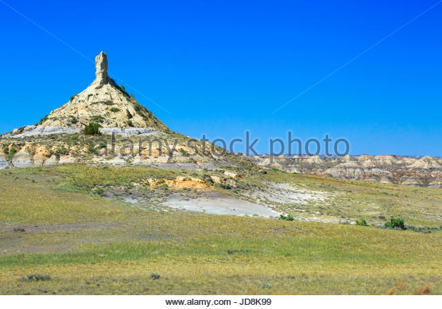
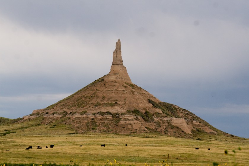
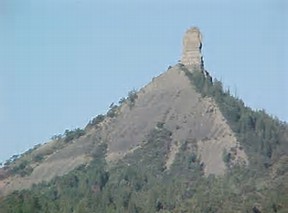
There are lots of Chimney Rocks. In this first type of Chimney Rock, you have a pyramidal shape with a phallic antenna. Pictured on top is a Chimney Rock in the Terry Badlands (another code word) of Eastern Montana; Chimney Rock in Nebraska; and the bottom photo is the Chimney Rock in Colorado.
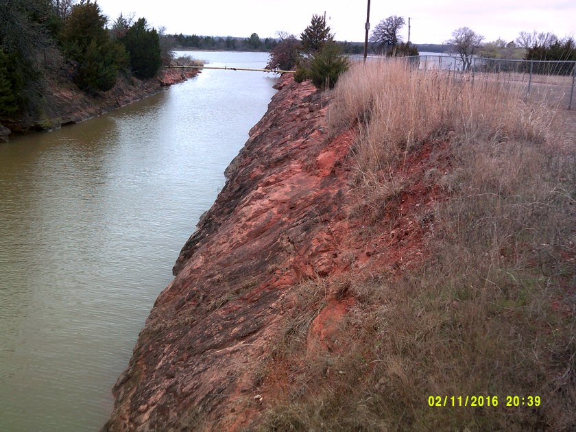
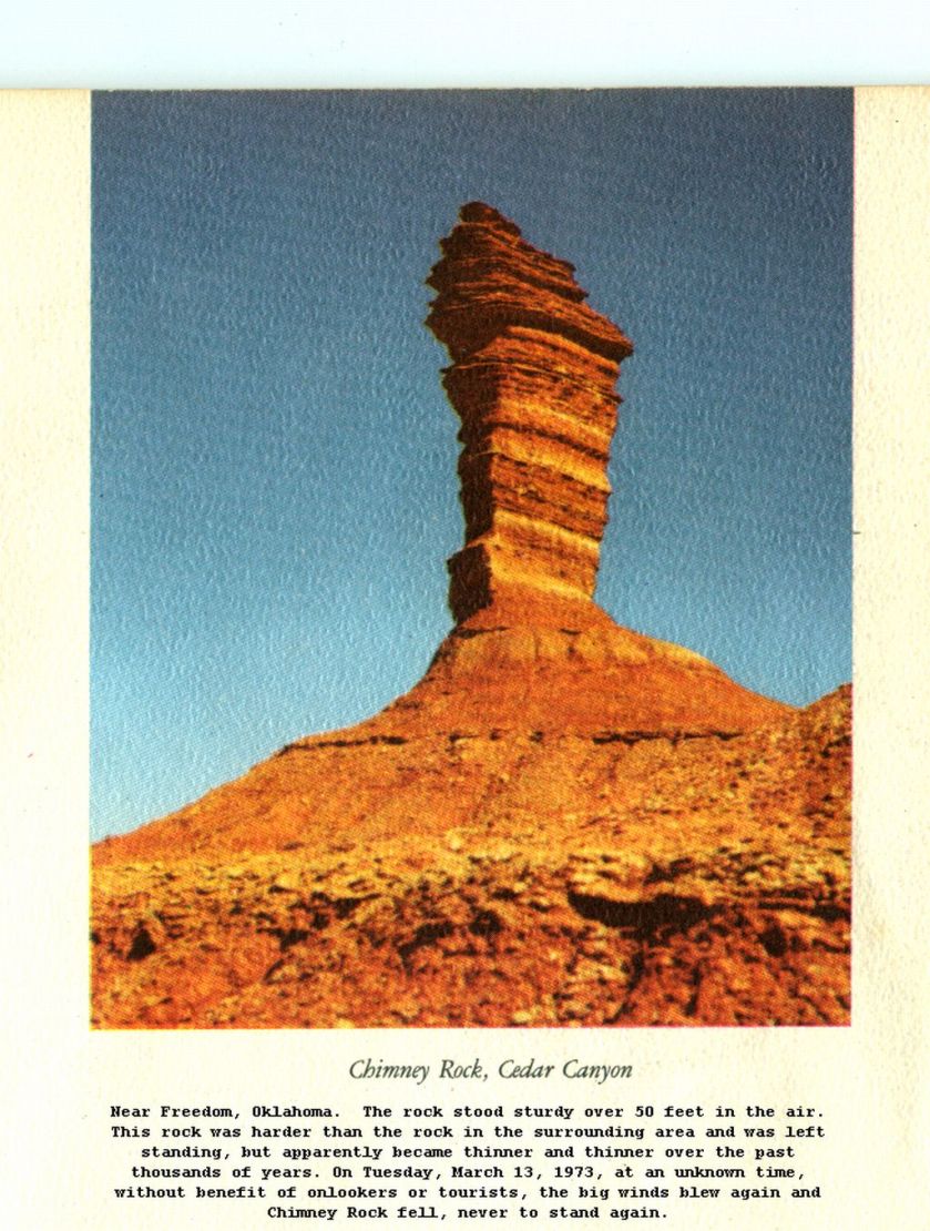
And this is an old photo of what was Chimney Rock in Freedom, Oklahoma, which is also the location of Alabaster Caverns (more code) and is also not far from Mooreland in Woodward County, Oklahoma. Now, they want us to believe, as captioned below the photo, this 50-feet high, sturdy rock was worn away so much over thousands of years, that one day in 1973, big winds caused it to fall without anyone seeing it happen.
My BS meter is pegged out on this one!!!
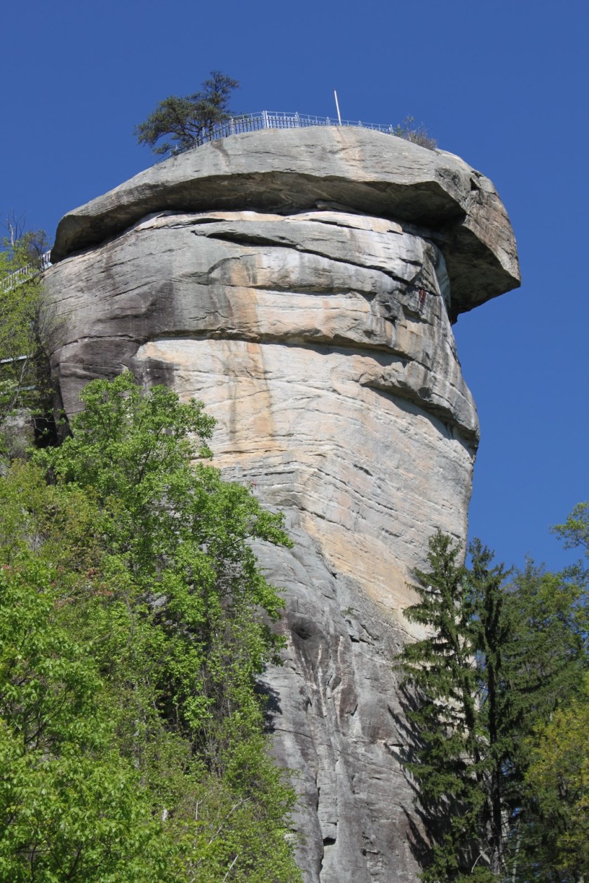
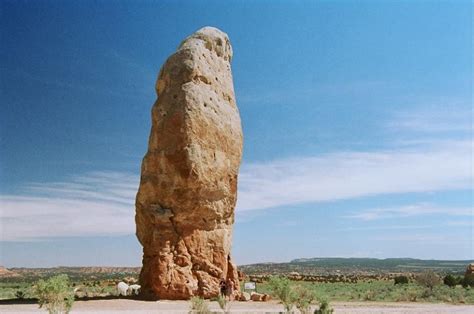
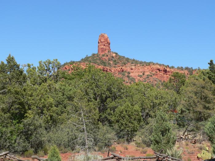
Moving on to another style of Chimney Rock, here are three examples where the shape is more phallic in nature overall: first, Chimney Rock in North Carolina; the second is Chimney Rock in Kodachrome Basin, Utah; and the third is the Chimney Rock in Sedona, Arizona.
I have come to believe that the phallic symbols represent a uniting of the energies of heaven and earth, and that they morphed into onion domes over time, representing the same shape for the same reason.
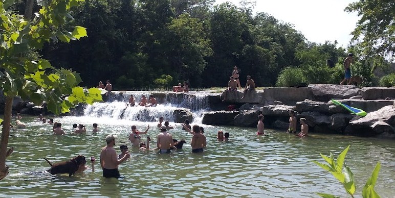
Next is the subject of Man-Made lakes.
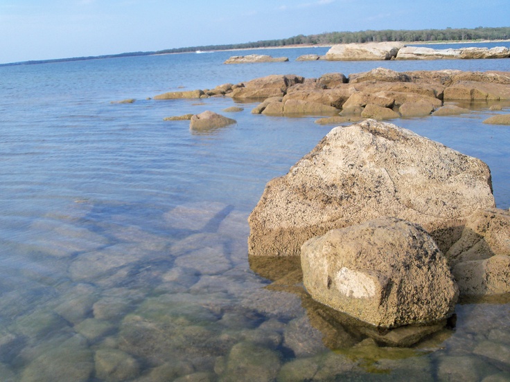
I was aware of two man-made lakes when I was growing up in Montgomery County and I related the experience of playing on big rocks as a child in the area of “Rock Creek” in Rockville, Maryland, and that this location was close to Lake Needwood and Lake Frank, and knew that both were man-made lakes. Lake Needwood has great recreational facilities, and I went there often in my childhood with family and groups.
I have come to understand that man-made lakes serve at least two purposes: 1) creating a water supply; and 2) covering up ancient infrastructure.
I realized early on in cracking the cover-up code that Federal, State, and local parks are part of it. So I started looking at pictures of parks on the Internet, which included a lot of man-made lakes.
In Oklahoma alone, there are more than 200 lakes created by dams, which is the largest number in any state in the U. S.
The first list of Oklahoma lakes are ones I looked at images on the internet. I primarily used the bing.com search engine, which was useful because in addition to your search item, they have section of “People interested in __________ also search for __________” and I got a whole lot more information about other similar places out of that process!
Keep in mind that rocks are key features of the Ancient Civilization….
Lake Altus
Lake Murray
Lake Texhoma
The next sets of pictures are lakes that I went to see in person.
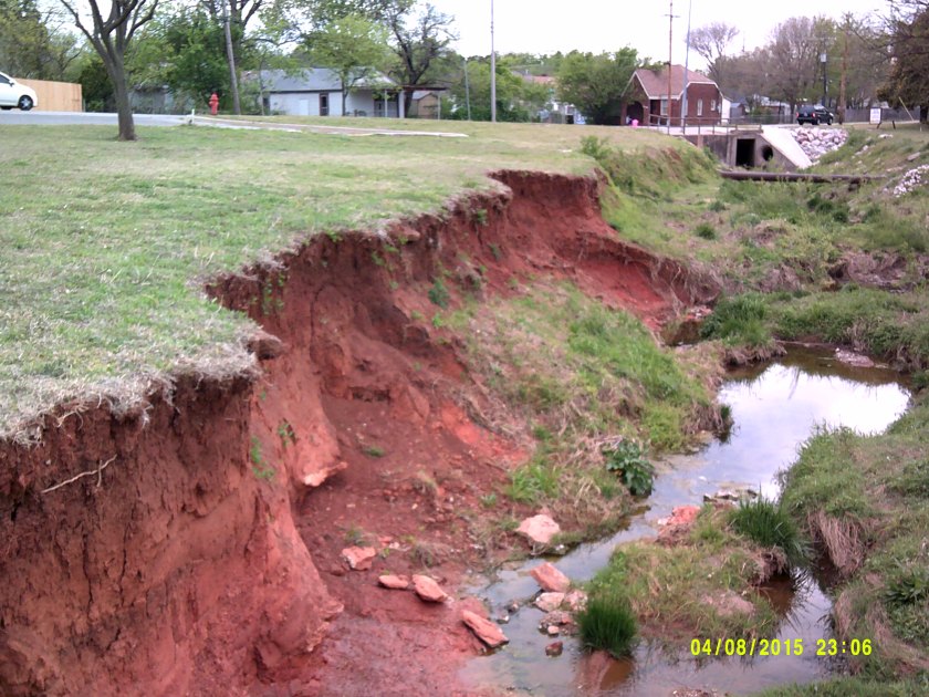
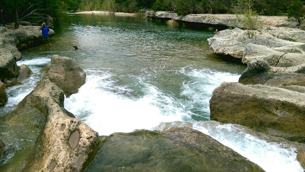
The first place I went to test my idea that man-made lakes covered up ancient infrastructure was Lake Thunderbird outside of Norman. I knew what to look for, and was not surprised when I found it:
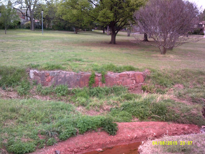
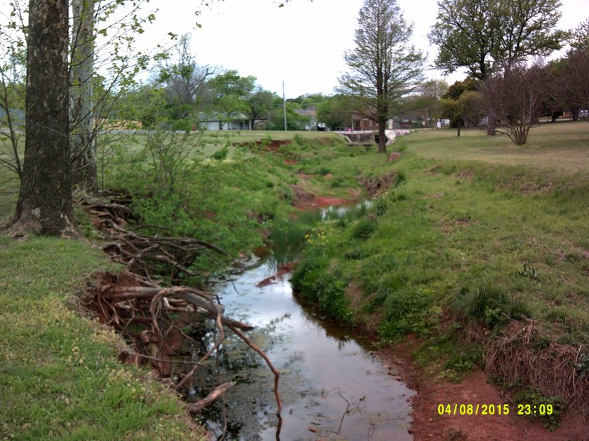
Found the same thing at Lake Arcadia, outside of Edmond:
Digital Camera
Digital Camera
Digital Camera
Digital Camera
Digital Camera
By the way, Lake Arcadia reminded me of what I saw in pictures of the Gulf of Bothnia, which is between Sweden and Norway, on an alignment I was following on my globe:
I found the same kind of evidence at other lakes outside of Oklahoma City, including Twin Lakes in Bethel, Oklahoma:
Digital Camera
Digital Camera
Digital Camera
Digital Camera
Digital Camera
The last thing I want to touch upon is what I found when I visited the man-made lakes in Oklahoma City. Lake Hefner is on the northwest side of OKC, and Lake Overholser is in the west side. Both of these lakes have huge slabs of concrete covering the lake shores!!!
At Lake Overholser, this is the only evidence of the ancient civilization I found: the ancient red rocks used to make the sign, and these big cut blocks of red rock behind the park office:
Digital Camera
Digital Camera
Lake Hefner itself didn’t really have anything to offer, but Martin Nature Park on the north-side of the lake sure did!
Digital Camera
Digital Camera
I have just shared a few examples of how the creation of man-made lakes covered up ancient infrastructure. It has been done everywhere. Not random or isolated occurrences. And the process created reservoirs for local water supplies.
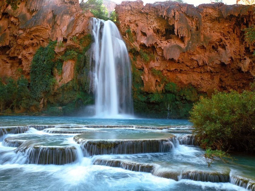
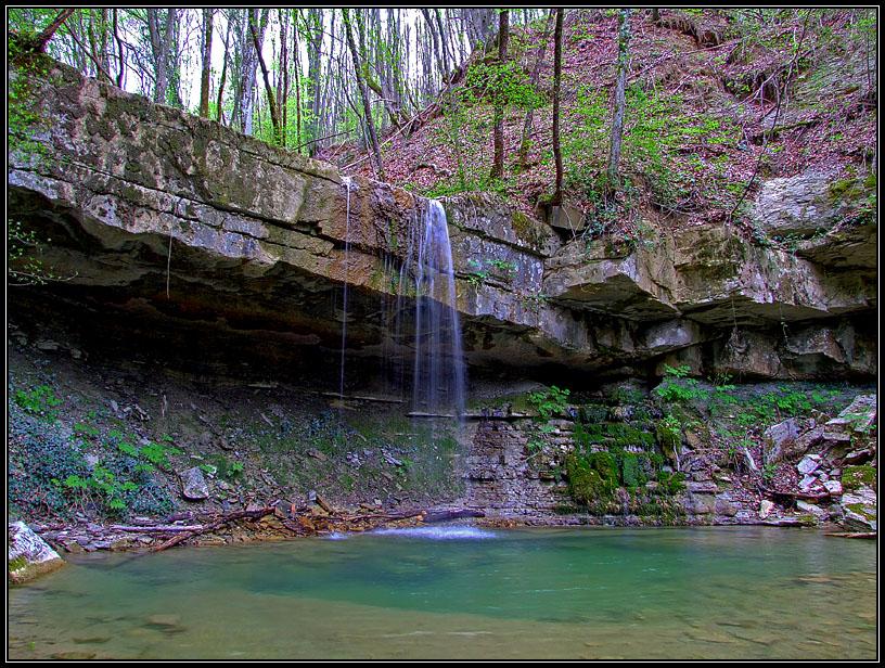
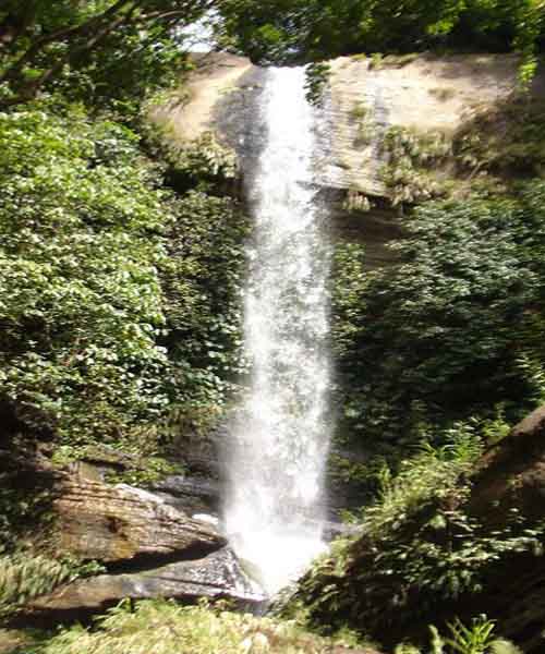
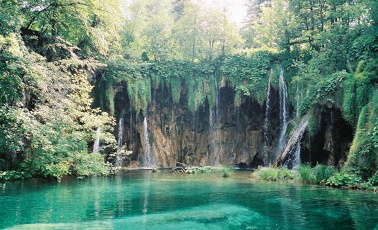
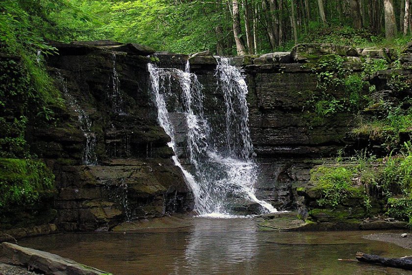
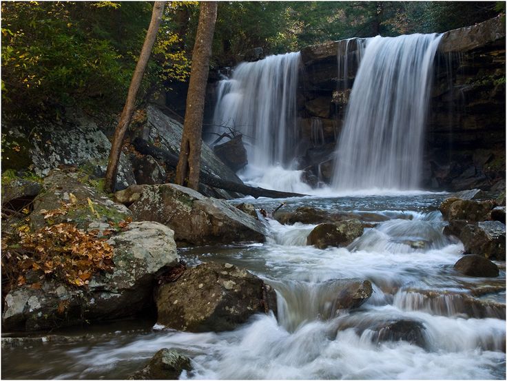
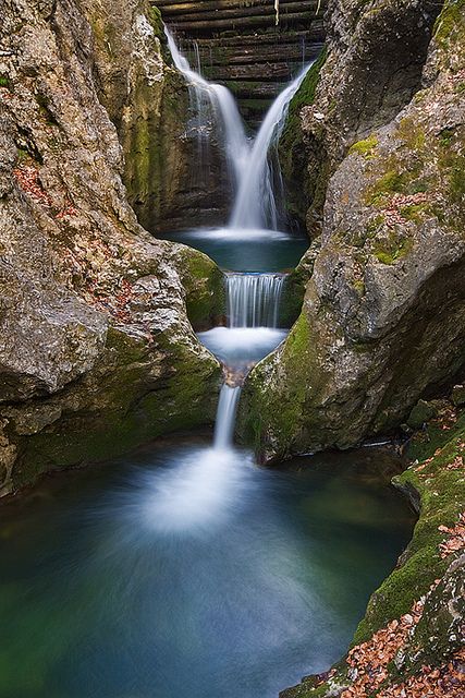
Waterfalls are a great example of what I am talking about when I say that from my studies of images and videos on the Internet, and some places I have visited, it appears to me that all of the infrastructure of the planet carries the same signature, the same hand of design.
Following the alignments that emanate from the North American Star Tetrahedron is what brought me to this place of understanding and these conclusions. I did not have these beliefs before I went on this journey. I was impulsed to go on the journey, and the more I got into it, the more information I received.
These examples just scratch the surface because there are so many waterfalls on the planet, and I know I can find many more examples of each kind.
I have put together pictures of waterfalls from different places with similar characteristics for the purpose of making a direct comparison so at least you can see what I am seeing and why I am saying it.
I believe that rivers and waterfalls signify something like Universal Energy Flows on the Planetary Grid system.
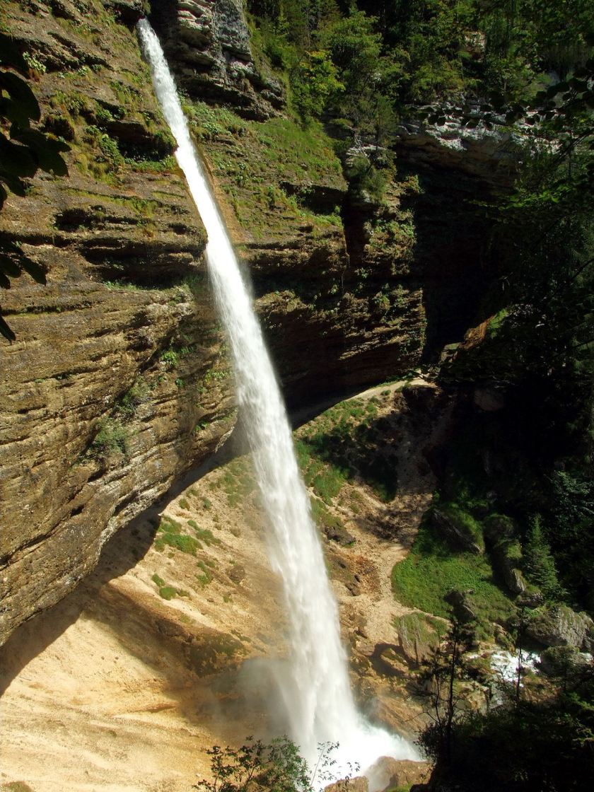
I made the claim fully prepared to support it with more examples – of the same style of waterfall in different places around the world. It looked like they had a selection of models of waterfalls to choose from, from small to large.
Like these:
I was already aware of the unusual appearance of Havasupai Falls in the Grand Canyon, not from visiting, but from some other exposures, including a music video by a musician called Gandalf, called the “Ancient Secret Path.” Here is the link to the instrumental music video – I believe it to be relevant: Gandalf – The Ancient Secret Path.
Havasupai Falls, Grand Canyon, Arizona
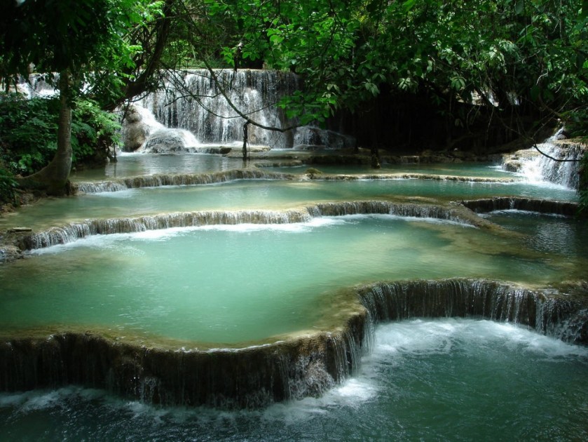
Then when I was travelling along the alignments from the Star Tetrahedron, I found this waterfall in Luang Prabang;
Luang Prabang, Laos
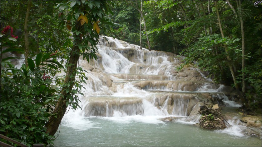
This one in Jamaica;
Dunn’s River Falls, Jamaica
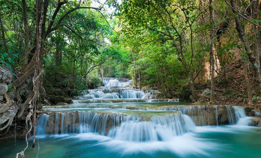
Another one in Thailand;
Erawan Falls, Thailand
And this one in Port Vila, Vanuatu.
Cascade Falls, Port Vila, Vanuatu
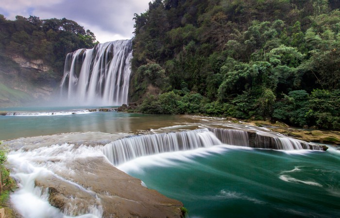
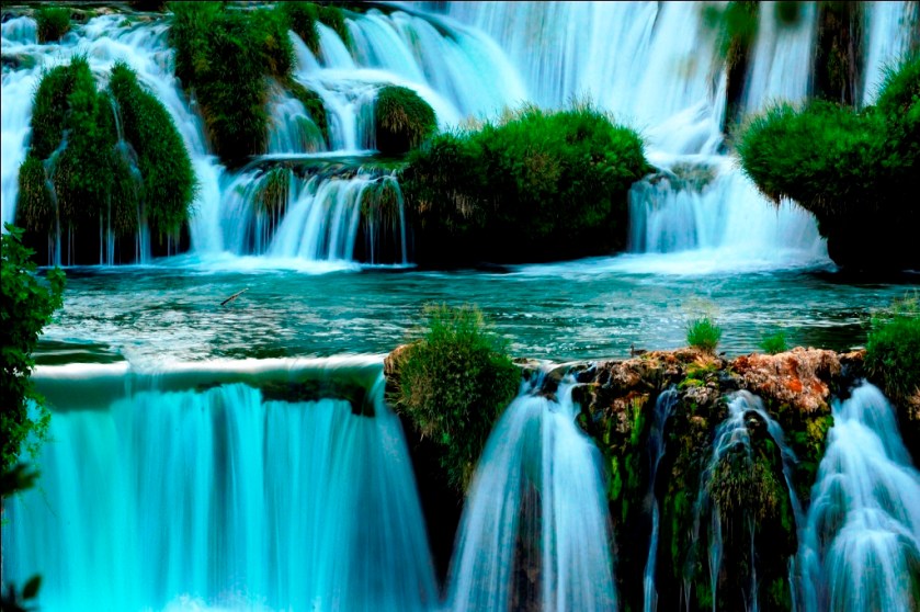
In the next series of waterfalls, in China, Croatia, Idaho, and Oklahoma, there is some massive engineering going on. Just look closely at the similarities in these pictures. There are very similar design features across continents. This actually includes the water color – a very beautiful blue (which goes for the the waterfalls pictured above as well). I also found Guizhou, China, and Croatia, by following grid-lines. I had no foreknowledge of this.
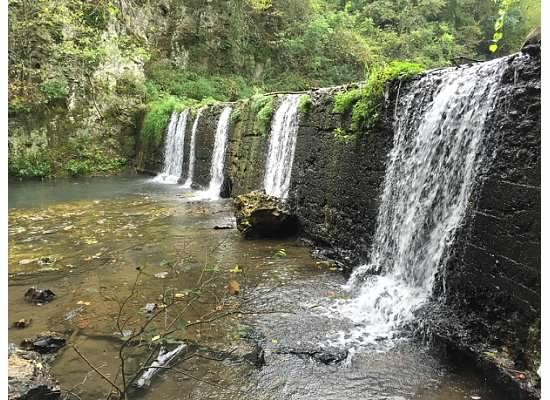
Huangguoshu Waterfall, Guizhou, ChinaHuangguoshu Waterfall, Guizhou, ChinaKrka Waterfalls, CroatiaTwin Falls, IdahoPlitvice Lakes, CroatiaTurner Falls, Davis, OK
Pictured in this series of three, the first is in Guizhou, China; the second is at Plitvice Lakes in Croatia; and the third is in the Chickasaw National Recreation Area in Davis, OK, near Antelope and Buffalo Springs. Not identical, but similar. In all three pictures, the surface of the water before it hits the edge of the waterfall, appears to be very still.
Digital Camera
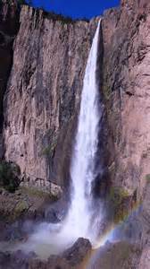
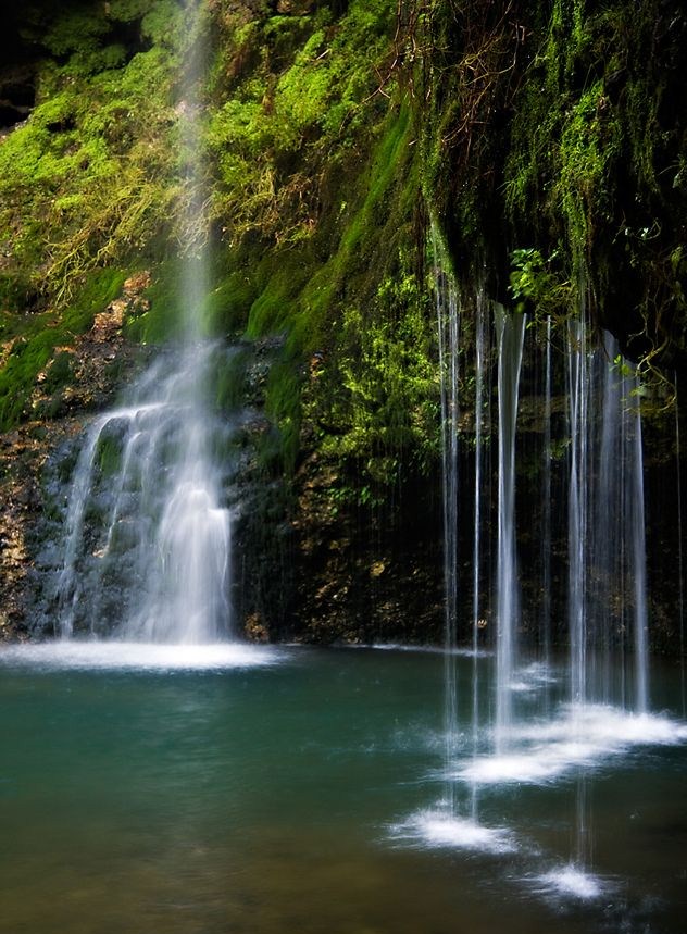
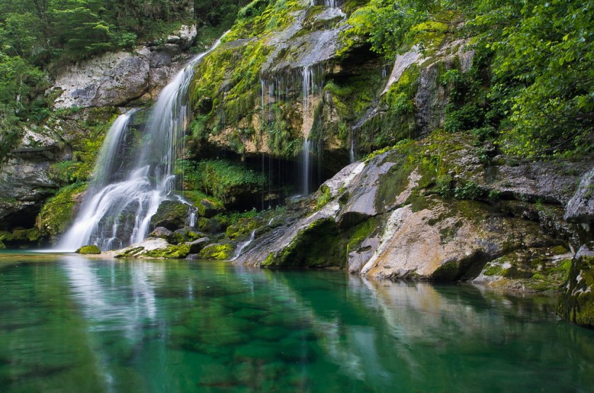
In the next series of waterfalls – in Oregon, Switzerland, Australia, Istria (Croatia/Slovenia), the Phillipines, Greenland, Mexico, Venezuala, British Columbia, and Bangladesh – you will see similaries in the flow of water from the top of what looks like a wall, and similar coloration.
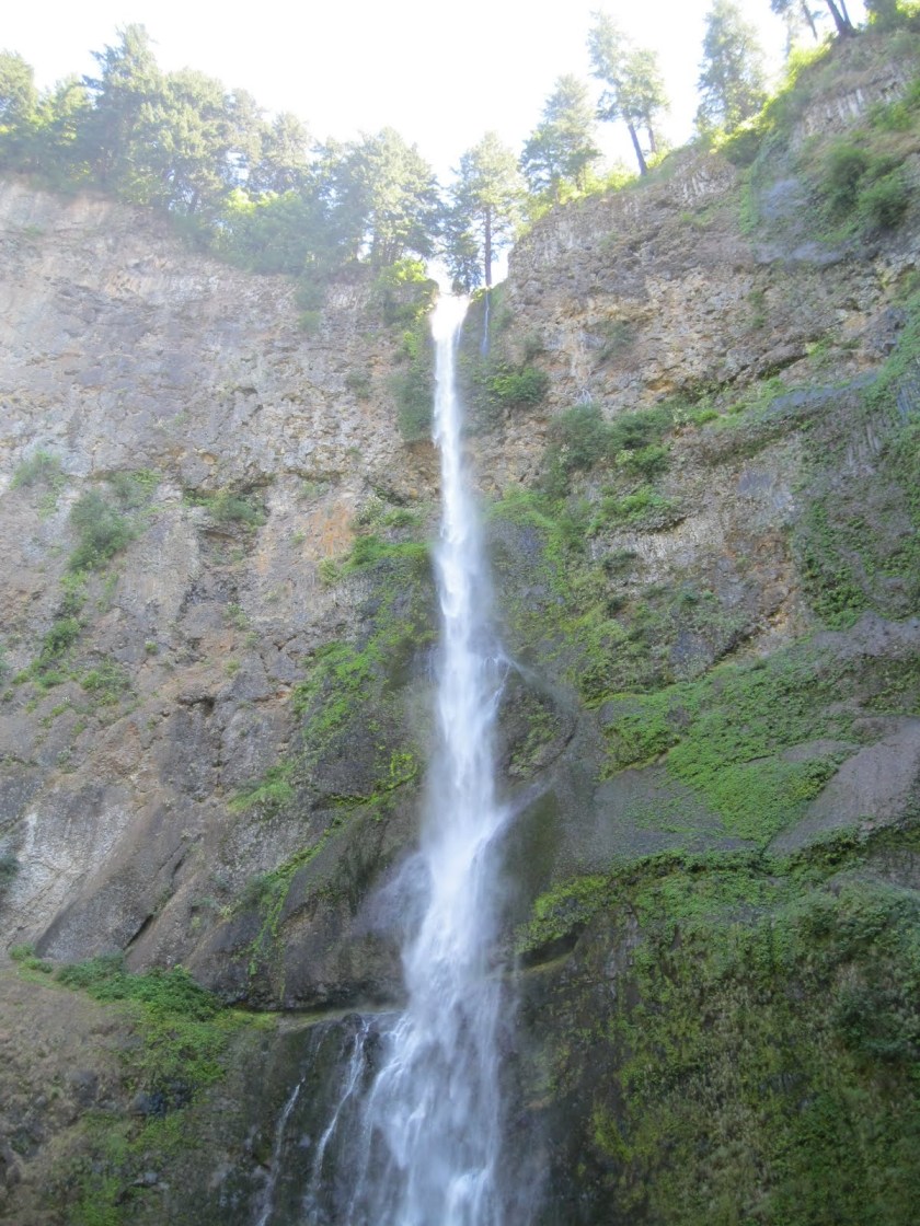
These are the Multnomah Falls, located in the Columbia River Gorge in Oregon:
Multnomah Falls, OR
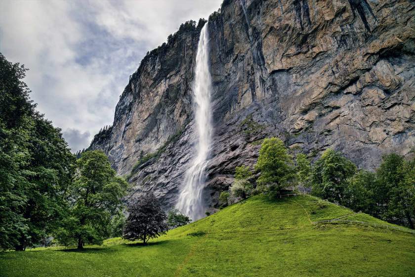
The Staubbach Falls in the Lauterbrennan Valley in the Bernese Alps. Note the mound-looking shape in the foreground.
Staubbach Falls, Switzerland
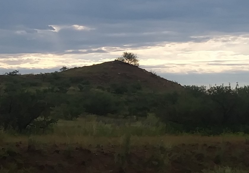
And the mound-looking shape in the foreground reminds me of this one in my drive into work in Arizona:
The Blue Mountains are known as part of the Great Dividing Range in New South Wales, and is near Sydney. I found the Great Dividing Range on a planetary grid line.
Blue Mountains, Australia
Slap Sopot is the second highest waterfall in Istria, which is a region shared between Croatia, Slovenia and Italy, and has a lot of waterfalls.
Slap Sopot, Istria, Croatia
Including this one, which has a lot of straight edges….
Istria Waterfalls, Croatia/ Slovenia
Croatia and Slovenia have a heck of a lot of waterfalls. Here’s another example of the same idea from this region. I believe we see ancient stone-masonry, not natural rock formations.
Slovenia Waterfall
Davao in the Phillippines is known as the City of Waterfalls, and has a lot as well.
Davao, Phillippines
I would like to make a comment about Cape Farewell, Greenland in a future post – it sits on a major alignment involving two aspects of the North American Star Tetrahedron.
Cape Farewell, Greenland
Basaseachic Falls also falls directly on a major alignments in the Sierra Madre Occidental Mountains, and Copper Canyon, in Mexico – the home of the Tarahumara. The Tarahumara are known for endurance running, and made this area their permanent home at the time of the Spanish Invasion.
Basaseachic Falls, Mexico
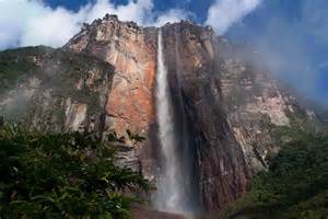
Angel Falls has the distinction of being the highest uninterrupted falls in the world.
Angel Falls, Venezuala
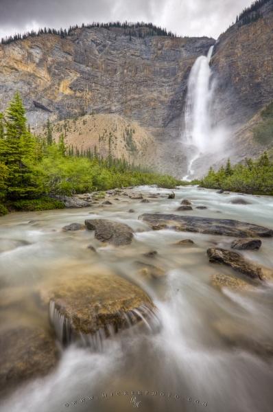
I found Takkakaw Falls in British Columbia by following a major planetary grid alignment. Not only do the falls look similar to those pictured above it, you have massive block-shaped rocks in the water-course in the foreground.
I don’t know about you, but before finding out all of this that I am sharing with you, I had no idea that there were such beautiful waterfalls in China, in Croatia & Slovenia (countries of the former Yugoslavia and part of the Balkans). In my head, growing up in the 60’s and 70s, the pictures in my head of these countries were like black & white movies because what we learned about Communist Eastern Europe & China – definitely un-beautiful images.
In the next set of slides, I chose this particular style to highlight because of Natural Falls State Park, OK. I visited there in the spring of 2016, on my way to visit Eureka Springs in Arkansas. By that time I had realized that the word “Natural” was one of the cover-up code words for the ancient civilization, and that parks are places that it is preserved, so basically, I had to go see it for myself. So I physically saw the ancient stone structures surrounding me as I took the path to the falls, like this:
Natural Falls State Park, OKNatural Falls, OK
Somewhere around this time, I was looking up waterfalls on the internet, and knew there was a similar looking one in Slovenia, which was in the former Yugoslavia. So I looked again to find it for this post and found one similar quite easily:
Slovenia Waterfall
As a matter of fact, I found another waterfall in Slovenia with a similar appearance:
Slovenia Waterfall
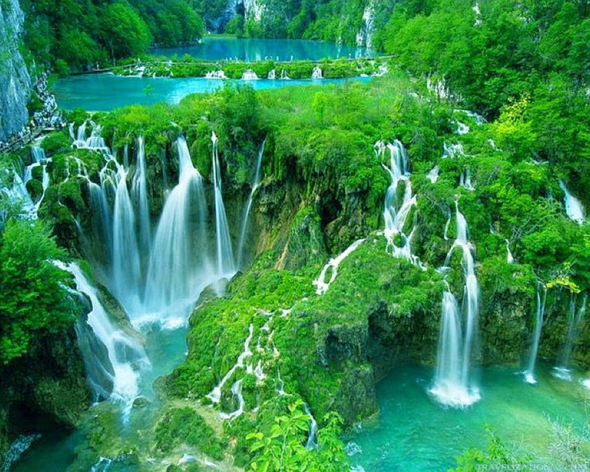
This next one is one of many waterfalls in Plitvice Lakes National Park in Croatia, which was also part of the former Yugoslavia:
Plitvice Lakes National Park, Croatia
In this side-by-side comparison, on the left is a waterfall in Slovenia; and on the right is Twin Falls on the Hawaiian Island of Maui. Leaving here for comparison:
Moving on to a different style of waterfall, check these out. Hang with me on this. Note the recurring similarities.
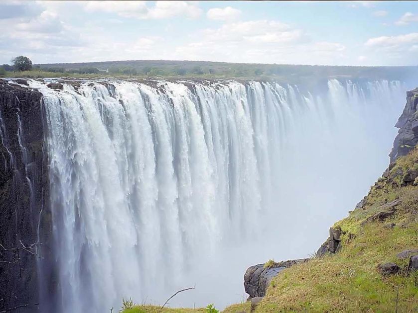
The first is Victoria Falls on the Zambezi River in Africa, considered the largest waterfall in the world by combined height and width:
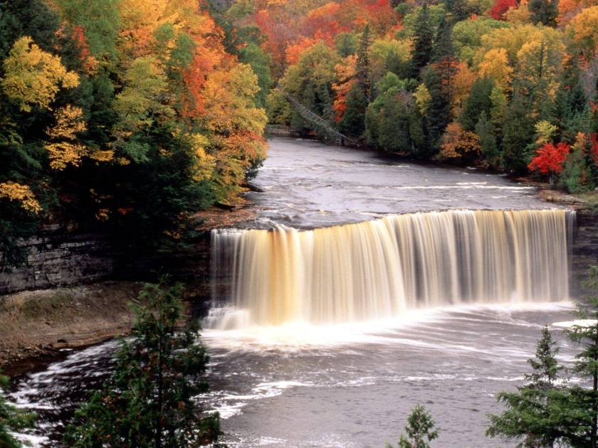
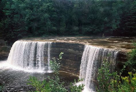
Next, you see Tahquamenon Falls in Michigan;
Tahquamenon Falls, MI
Mackinac Falls in Michigan;
Mackinac Falls, MI
Another part of Natural Springs State Park in Oklahoma called Dripping Springs;
Natural Falls State Park, OK – Dripping Springs
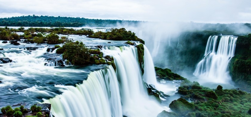
Iguazu Falls straddles the border of Argentina and Brazil. The picture below is from the Argentina side;
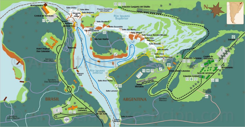
I included this picture of the map of Iguazu Falls between the two countries to show its lay-out. Of particular note is the configuration on the Brazil side that has a very round geometric-looking shape.
Map of Iguazu Falls between Brazil and Argentina
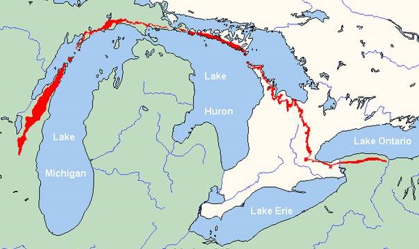
I have included this map of the Niagara Escarpment to show another long-distance configuration that is remarkably geometric when you consider the distance it covers – straight line in Western New York and into Ontario, and from there a nice and neat half-circle shape across the top of Lake Huron and Lake Michigan, and then down into Wisconsin.
Niagara Escarpment
Here are some photographs of waterfalls that flow off of the Niagara Escarpment. The first is of a waterfall in Ontario;
View of Falls on the Niagara Escarpment in Ontario, Canada
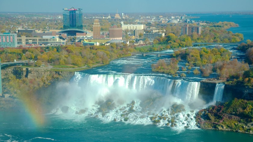
and the second is the American-side of Niagara Falls just outside of Buffalo, New York:
Niagara Falls, Buffalo, NY
Lastly, a comparison photo to show the similarity of a view of the Niagara Escarpment on the left, and view of the Endless Wall at the New River Gorge State Park in West Virginia.
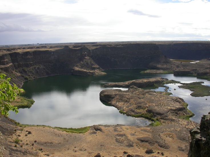
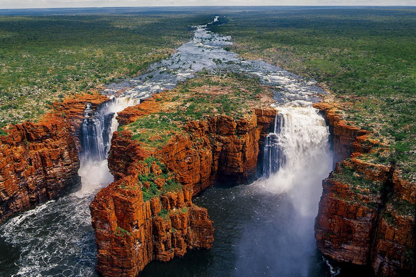
In my video “Physical Evidence for a Planetary Grid System…and a Suppressed Global Civilization,” I included photos of Dry Falls in Washington State, and the Falls pictured here in the Kimberley. I found the Kimberley Falls by following the alignments I found. I heard about Dry Falls in a lecture I was listening to on Youtube. Note the double fall configuration and the flat landscape.
Dry Falls, Washington StateKing George Falls, the Kimberly, Australia
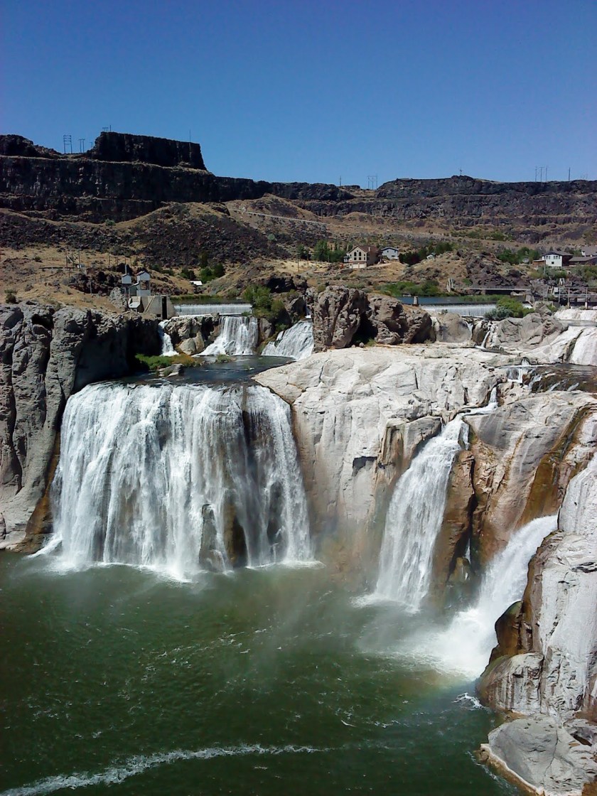
Twin Falls, Idaho again;
Twin Falls, Idaho
The next two pictures were from Twin Falls State Park in Washington State. In particular, there is a really wispy quality to this waterfall that is reminiscent of many others;
Twin Falls, Washington State
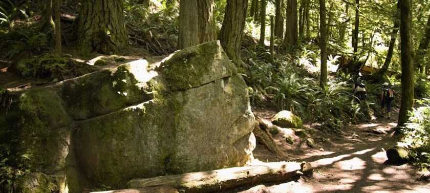
and in the park itself is this block of stone that looks like masonry to me. Note the shaped angles, and the straight cut in the stone towards the top.
Twin Falls State Park, Washington
The next two are of Twin Falls in Austin, TX:
Twin Falls, Austin, TXTwin Falls, Austin, TX
Two pictures of Twin Falls in Seneca, New York;
Twin Falls, Seneca, NYTwin Falls, Seneca, NY
Twin Falls in Richland Creek, Arkansas;
Twin Falls, Ozarks, AR
And Twin Falls State Park, in Mullens, West Virginia.
Twin Falls, WV
To be clear, I see beautiful stonework and stone masonry in these waterfall photos, made with intention and not randomly, and similar design features in places far from each other.
The Ancients worked wonders with stone. Their true legacy is kept from us, and is all around us, hidden right in front of our eyes. The fullest expression of Human Potential that there has ever been on Earth.
I will leave you with this picture of a beautiful waterfall in Slovenia to emphasize what I am saying. Sure, you can say this last picture, and all waterfalls, can only be the result of natural geological forces. Examine this picture closely. Could there possibly be another explanation for its existence, and many others, that we have not been told about? Are you absolutely sure after what I have shown you that all of this can be explained by a random process of natural forces?
I promised to talk about castles in North America in the blog post “The White-Wash of Europe.”
Again, according to our historical narrative, there was nothing like that in North America, no castles, no nothing – an empty land, free for the taking. It’s not supposed to be here, so we assume that whatever we are told about different places is true. So if we are told a structure like a castle was built in the 1800s, or early 1900s, we believe it. Why shouldn’t we? What we are taught about history must be true. But this is if the premise of what we are told is true. That is not what I have come to believe, which is that there is a cover-up about the advanced Ancient Civilization.
Please compare these two sets of photos.
First, in North America, three of Canada’s Grand Railway Hotels: the Place Viger Hotel in Montreal circa 1898, on top, and the Fairmont, Chateau in Ottawa, said to have been built between 1909 – 1912 (please note the nice canal-looking Ottawa River in the foreground – for more on this, please check-out the “Master Mason & Canal” post); and the Chateau Frontenac in Ottawa.
The Canada Railway built these, right? That’s we are told…:
Here’s the second set in Europe for comparison:
First, the Ksiaz Castle in Poland, built between 1288-1292; and middle – Chateau de Chambord in France in the Loire Valley, built between 1519 and 1597; and the Schloss Drachenberg on the Rhine River near Bonn, Germany, said to have been built between 1882 and 1884:
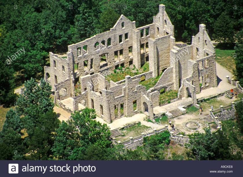
Moving on, these next ruins are called The Castle at Ha Ha Tonka State Park in Missouri. It is said to have been started in 1905 by a Kansas City businessman, and finished by his sons in the 1920s before the stock market crash. We are then told, after being used first as a seasonal home, and then as a hotel, it was destroyed by a fire in 1942.
A home? Really? Okay, a hotel, yeah. Right, a stone building destroyed by fire.
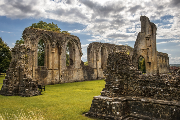
It reminds me more of Glastonbury Abbey ruins in England:
Glastonbury Abbey was taken literally apart by mobs during the reign of King Henry VIII during the Dissolution of the Monasteries in 1539.
Speaking of ruins, here are some more interesting examples in the U. S.:
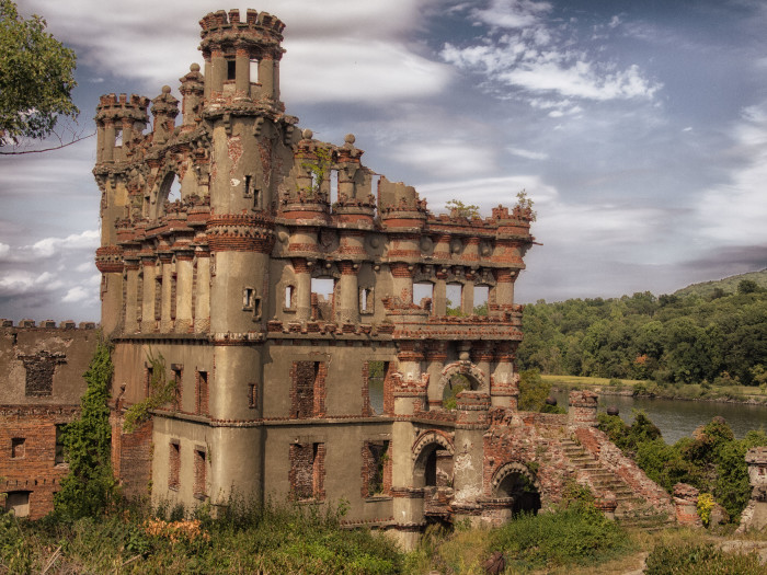
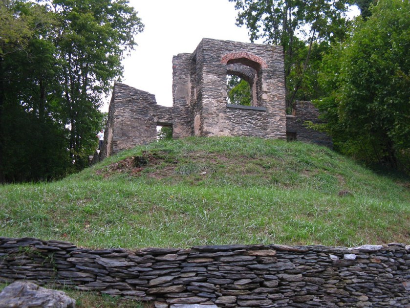
This ruin known as the Bannerman Castle, and is located in New York State, on the Hudson River:
Then, there is Boldt Castle, in the New York portion of the Thousand Islands , named after a turn-of-the-century businessman. As the story goes, construction was started in 1900 and stopped in 1904 due to the death of his wife. You can believe that if you want to, but saying so doesn’t make it so. Just saying. Our historical narrative just left out any other possibility. Compare to the pictures of North American and European castles above. Same design features.
But, Michelle, we were smart enough to figure out how they designed it! Easy peasy, even in 1900!
Don’t know if you have ever heard of Flower Pot Island in the Bruce Peninsula National Park in Georgian Bay, Ontario, but check this out:
I see advanced the advanced Ancient Civilization all over Canada from connecting the global dots.
Could these so-called flower-pots, and stone-environs, just happened naturally? Just because we don’t want to admit that something is amiss in our reality?
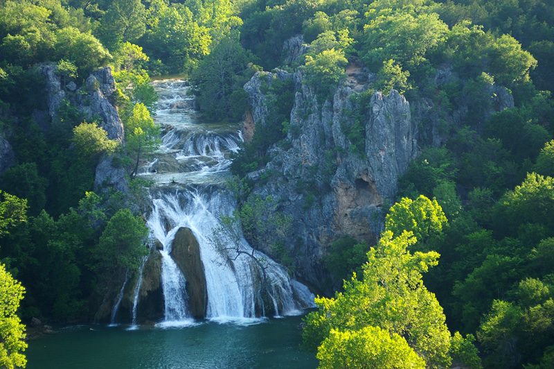
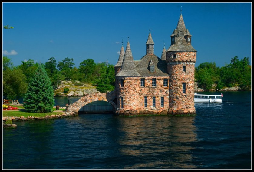
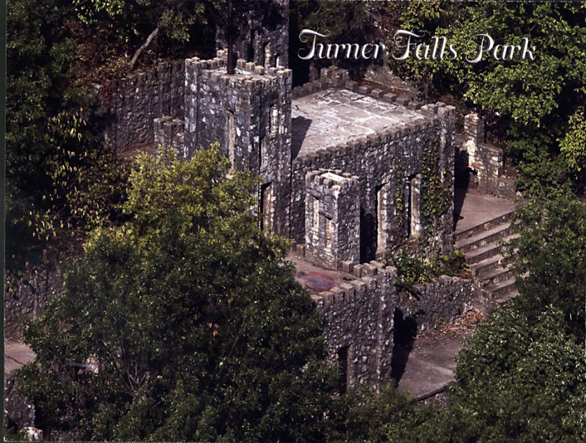
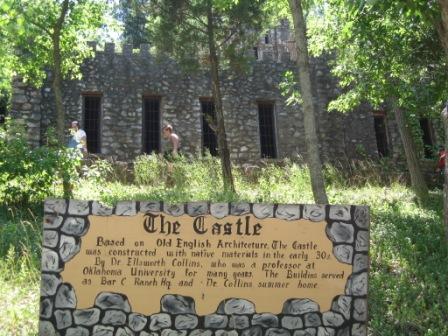
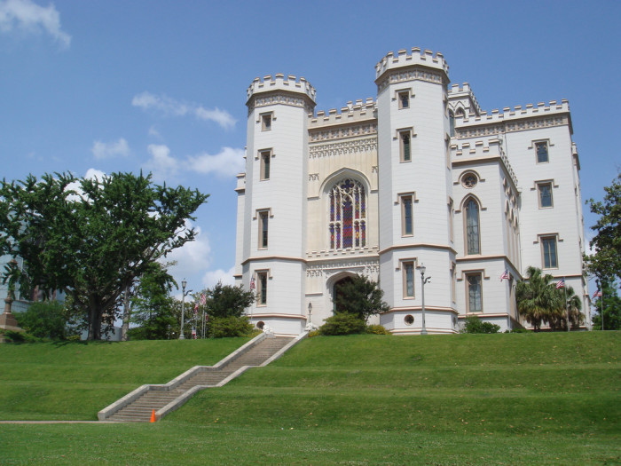
The next photos are of the Castles at Turner Falls State Park in Davis, Oklahoma. The first is a good view of the relatively intact castle; the second is signage saying that the castle was built in the early 1930s; and the third photo is of another stone structure on the grounds of the state park with a lot of missing stones.
On to:
Castles of Louisiana (the Heart of the Washitaw)
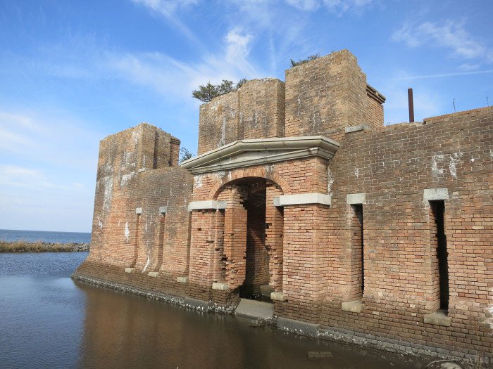
Baton Rouge (check out the nice earthworks underneath the castle…)
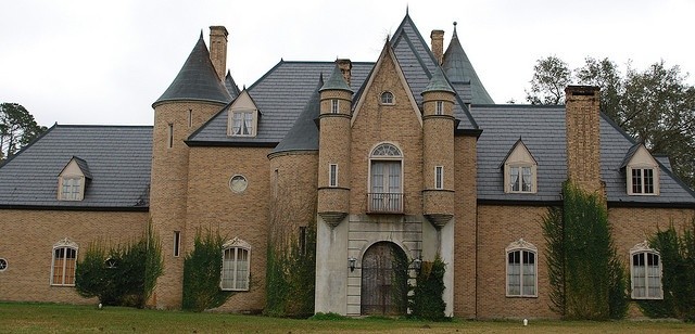
and presenting Beauregard Castle in Louisiana,
and Mementau Castle in Louisiana,
Louisiana is an integral part of the Washitaw Empire….
Lastly, I leave you with images from Harper’s Ferry, West Virginia. So we are told, a major engagement in the Civil War, and John Brown’s last stand. But what if, the stones tell a different story of history?
The top picture is supposed to be of St. John’s Episcopal Church (built on top of an earthwork).
The photo on the left was taken at Virginius Island, Harper’s Ferry; and on the right, the Ancient Waterwheels at Faiyum, Egypt.
This photo was also taken at Virginius Island. I know what I see…and it isn’t farmers. Or indians.
Master Masons – who were Master Astronomers & Astrologists, Master Engineers, and Master Hydrologists – were central to the Ancient Civilization. They left us an incredible legacy, leaving us many Mind-Boggling Wonders that western “experts” try to explain, but really can’t. Those “experts” devise ridiculous explanations to try to illustrate how slaves, ropes, and pulleys could have been used to move multi-ton blocks that are shaped and fitted perfectly. They really don’t have a clue.
As I like to say, there would be no mysteries in history if we had been taught the True History – that there was an Advanced Ancient Global Maritime Civilization that existed up until relatively modern times that was deliberately removed from our collective memory. To learn more about this legacy, click on: Clock of Destiny – Moorish International College of the Great Seal
We know many of their accomplishments in the known Megalithic Sites, including along the lines of UNESCO World Heritage Sites, but they are certainly not given credit for them. Aliens are more likely to get credit than Moorish Masons. I have long believed if History Channel had called their popular program “Ancient Humans” instead of “Ancient Aliens,” it would have been pulled from the air a long time ago. I am grateful, though that the show brings forth related-topics to the mainstream that would not otherwise receive coverage. In my work of revealing what has been hidden, I am going to share many examples throughout this blog of how the ubiquitous handiwork of these Master Builders has gone unrecognized, unacknowledged, and unprotected. Their legacy has been suppressed, falsely claimed, and exploited.
Before I move on to the main subject of this blog, here examples of the exquisite masonry of Quillirumiyoc, a very ancient site, and the Coricancha in Peru, from a recent trip to Peru.
Quillarumiyoc, outside of Cusco, Peru
The Coricancha, in Cusco, Peru, and the Navel of the Earth
First, let me start off by saying that there are known canal systems, and many, many more unknown canal systems.
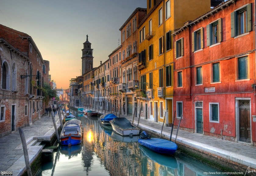
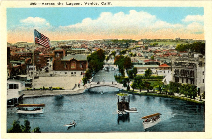
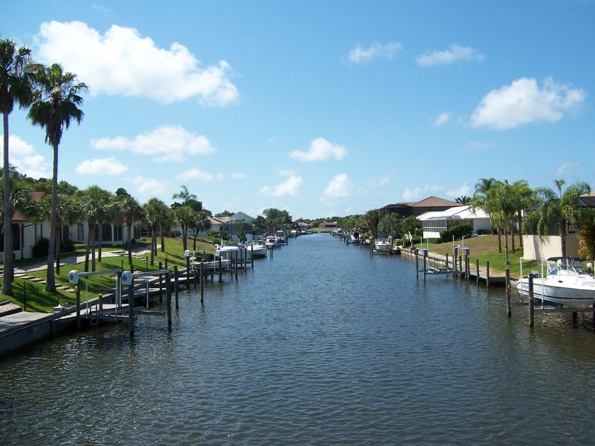
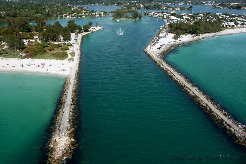
Let’s start with known canal systems. First, actual Venices, from top to bottom: Venice, Italy; Venice, California; and the last two photos are of Venice, Florida.
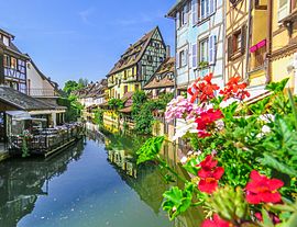
Then, places known as Little Venices – pictured on top is Colmar, France, in Alsace-Lorraine; and Port Grimaud, in the French Riviera:
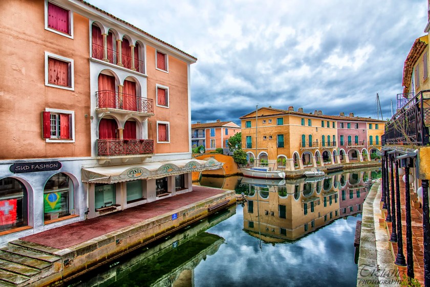
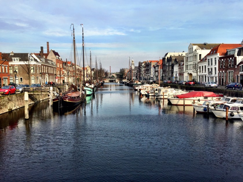
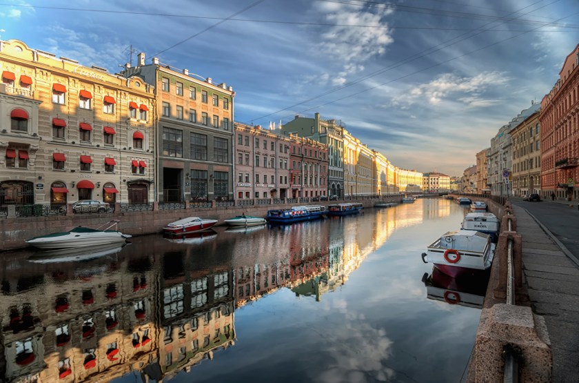
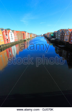
Then, some lesser known places in Europe with a canal system, top to bottom – Rotterdam, in the Netherlands; St. Petersburg, Russia; and Trondheim, Norway:
Did you know anything about this? Are similarities of canal lay-out and design in these photos consistent with what we have been taught about world history?
Notice the beautiful reflections of the sky and buildings in the still water of the canals depicted in several photos. The Moors were all about bringing heaven to earth and earth to heaven, harmony and balance, in everything they did. Their genius represents the highest potentials of Humanity on earth in action.
There is also a sophisticated canal system throughout Great Britain, including elevated sections. Here is a photo of the Pontcysylite Aqueduct in Wales, about which we are told the construction began in 1795, and was completed in 1805. That’s better than the 2 years in which we are told the Nashville Parthenon (referenced in my “Why is this Relevant Today” blog post), but still…what do you think, given the technology we are taught to believe existed at the time? Maybe it coincides with the Industrial Revolution that started in Great Britain around 1760, but construction of this sophisticated engineering feat started only 12 years after the end of the American Revolutionary War in 1783? And is said to have finished in 10 years? Okkaayy….
Moving on to North America’s known and unknown canal systems. I would like to start off by introducing you to John Jensen’s work on Ancient Canal Builders. He has done excellent work on researching this subject.
I touched on the subject of the C & O, and other canal systems in North America, in my post called “Family Background & the Beginning of Awareness.” In that post, I expressed my belief, based on the evidence I shared in that post about the C & O canal, that these systems were built by the advanced ancient civilization that was long-established here when the Europeans first arrived.
The next photos are of the Erie Canal, and one of an Erie Canal Aqueduct. I am calling this sophisticated engineering and masonry. We are told that the construction of the Erie Canal itself started in 1817 (again, well before the beginning of the Industrial Revolution in America in the mid-1800s). And this Erie Canal Aqueduct is reminiscent in style, though not scale, to the Pontcysylite Aqueduct in Wales, shown previously.
Next, here are photos take of St. Lawrence Seaway, which is described by Wikipedia as a system of locks, canals, and channels, in Canada & the U.S. that permits ocean-going vessels to travel from the Atlantic Ocean to the Great Lakes. The first is through Montreal; and the second is St. Lawrence Seaway, but it is not specified where. Remember what I keep saying about block-shaped rocks…they are shaped and cut, and are not natural!!!!:
A
Next on to unknown canal systems. I am going to focus on Oklahoma, because this is where I have studied it the most, but I believe the canal system was very important to the Ancient Civilization as a transportation system, in addition to a land-based road system, because it was in fact a Maritime Civilization. They were as comfortable on the waters as on land.
I am going to start with these photos taken at the same location at 36th Avenue & Shartel Avenue in Northwest Oklahoma City:
The first photo on the left is very reminiscent of what the river beds look like in Oklahoma – red clay gashes. In the middle photo you will see what look to be the remains of stonework still in place. In the last photo, you see where the root system appears to be growing out over air?
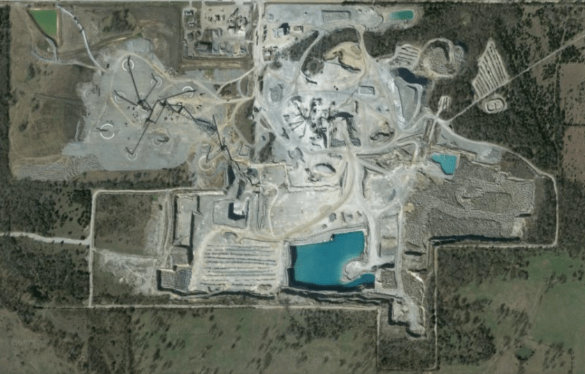
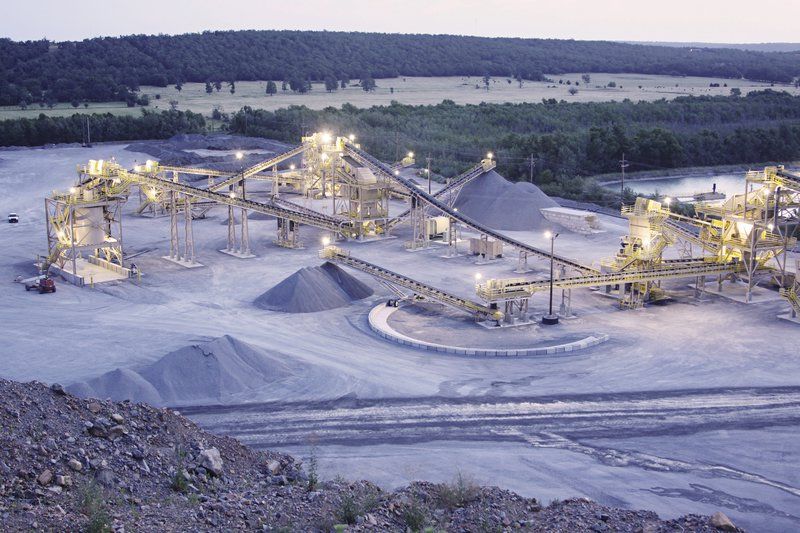
This is as good a place as any to assert my belief that the cement industry is built upon pulverizing ancient masonry. It’s not supposed to be there in our historical narrative, so we don’t even conceive of it, so certain industries can do whatever they want because it doesn’t exist. The following pictures are all connected with the Dolese Quarry, based in Oklahoma, which is a major company providing aggregates, concrete, and products used for building. They are not the only example, but the first that I became aware of.
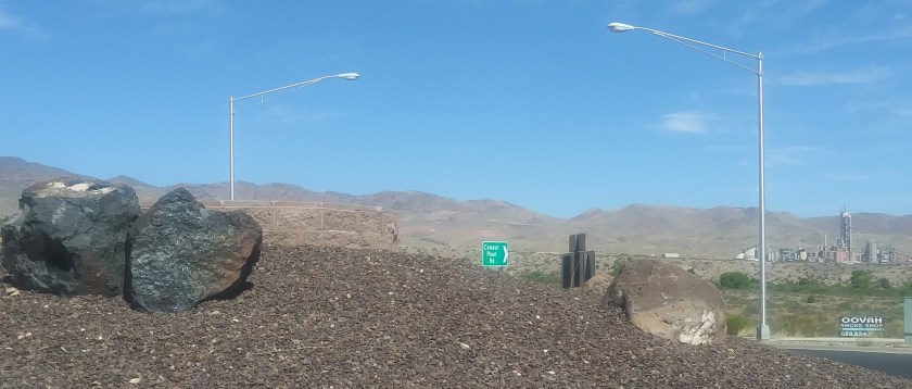
This is a photo taken of a roundabout, with ancient masonry blocks in the foreground; the road sign saying Cement Plant Road in the middle of the picture; and in the distance you are seing the Cement Plant in Clarkdale, Arizona. And there’s plenty of ancient masonry everywhere in this area, so they will never, ever run out of raw material. That is how massive this Ancient Civilization was, that there is an inexhaustible supply of unrecognized masonry for the cement industry all over the world.
As with all of this information, I can dig up more examples. Suffice it it to say, there’s a whole lot of this going on.
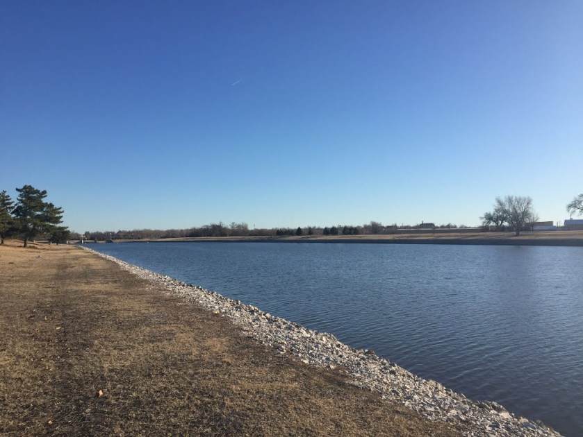
Lastly, the subject of totally unknown canal systems. I have a picture here of the Oklahoma River. Very straight. It…looks like a canal:
As a result of what I seen throughout Oklahoma, I believe the remains of a canal system are obscured, or the water flow cut-off to the point of former canals what are called ravines. Here is a photo at Twin Lakes, which is also a man-made lake and water supply, in Bethel, Oklahoma, near Shawnee, OK. How big of a stretch is it to see this as an ancient canal?
I may add later to this post as I think of more things. This is a good start.
After I became aware of the existence of the North American Star Tetrahedron, and as I started to become aware of the symmetrical, geometrically-shaped features of the landscape when I was living in Central Oklahoma, I started to see how the layout of the grid and ancient infrastructure were being utilized by the energy industry unbeknownst to the general population. This is one of many things which remains hidden because no one knows about, and we are encouraged to think that everything is “random” and “natural”. I believe the terms “fossil fuel” and “natural gas” are misnomers, and that our modern energy industry is actually based on ancient energy technologies.
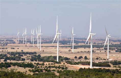
For example, we are told that these are wind turbines. Pictured in this photo, west of Oklahoma City in Okarche, there is a massive wind-farm spread across the landscape. However, these turbines not just placed anywhere – they are placed in a relatively linear fashion within a defined space. So their placement appears to be intentional, and not random. Also, all of the wind turbines that are running go at the same speed, regardless of whether the wind is blowing. I really question whether they are actually being powered by wind, or by some other technology. Wind turbine farms have popped up in different places in Western Oklahoma, and the Texas Panhandle. From what I could see, turbines are typically associated with cities with an energy industry connection, like Woodward, OK, and Enid, OK, where I would see a line of them. More on these two places shortly.
I came to realize that the wind turbine line-up in Okarche approximates with the lines in the star tetrahedron, and as you can see, Oklahoma is located where two major lines cross.
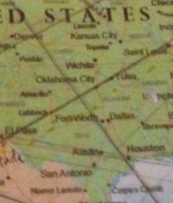
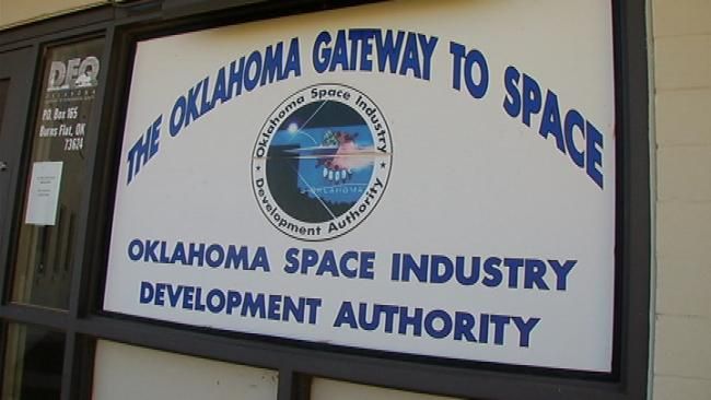
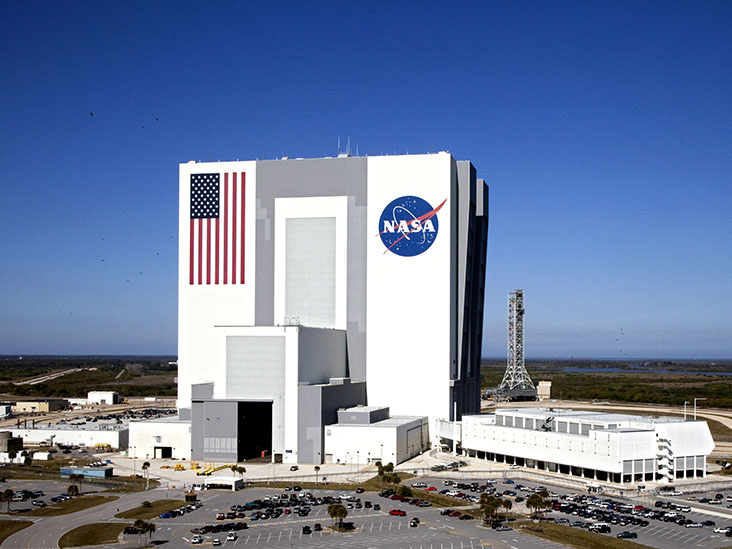
Burns Flat, Oklahoma, in Washita County, sits approximately where the two lines cross, and is where the Oklahoma Air and Space Port is located (Oklahoma Space Industry Development Authority).
Please note on the map show that Houston, TX, location of NASA’s Johnson Space Center, is further down on the same alignment.
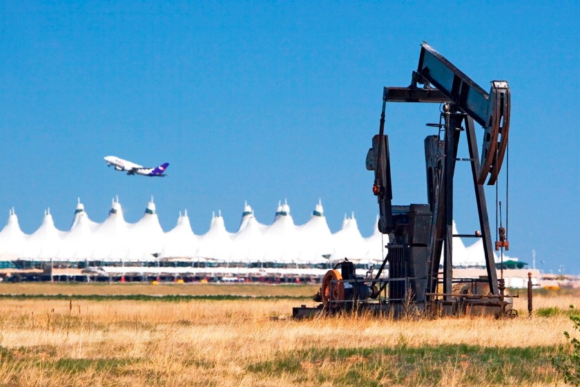
And the Denver Airport is approximately located at the center of the star tetrahedron, is further up the alignment.
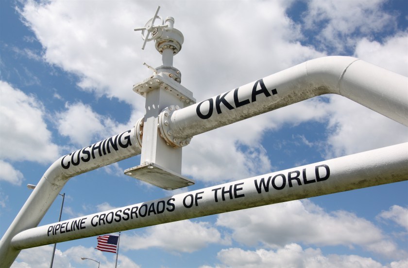
Cushing, Oklahoma, located between Stillwater, OK, and Tulsa, OK, is called the “Pipeline Crossroads of the World” hosts the world’s largest tank farm.
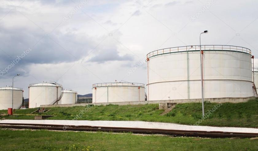
Speaking of tank farms, I came to realize that they are typically situated on top of what appears to be earthworks. Here are two examples, but very typical of the types of things I started to notice as I was becoming more aware.
Thus, as I became more aware of what was actually in the landscape around me, I started to actively investigate what I saw by actually going to unusual features in the landscape. As a result of the work, I had a shift my perception, in which an environment that blended together and seemed ordinary, became the infrastructure of an ancient civilization.
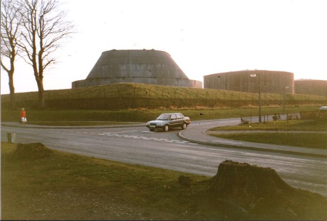
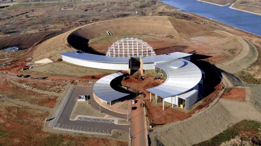
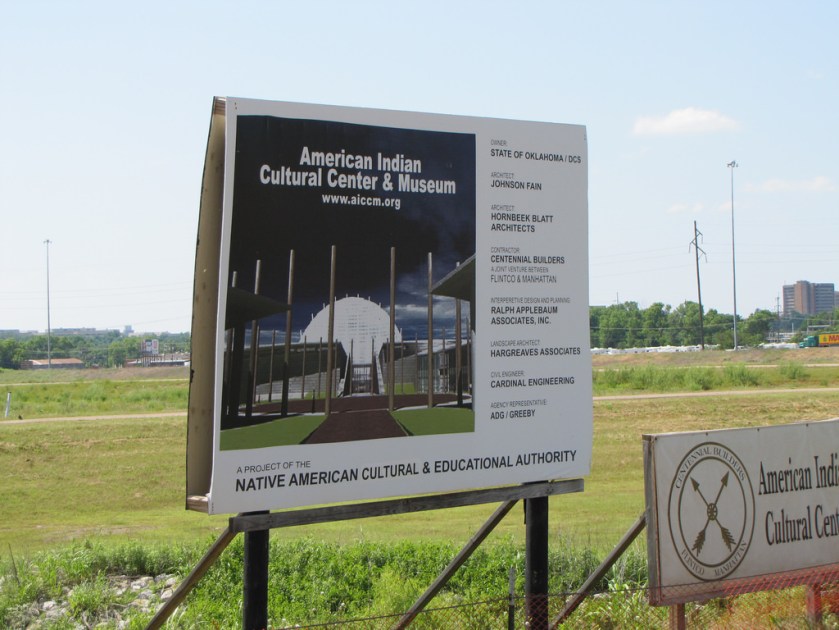
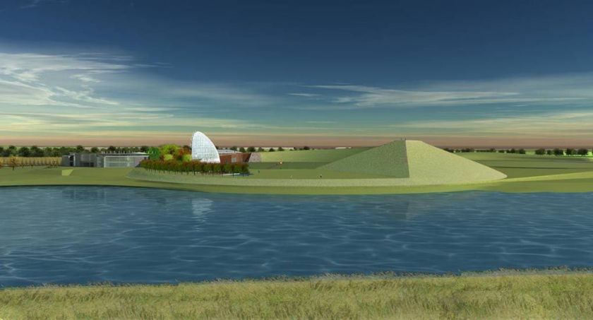
I soon noticed from I-40 a really unusual looking structure that is located right next to the Oklahoma River, at the corner of I-40 and MLK Boulevard on the south side. Again, until I tuned into it, I didn’t see it. I’m like – what the heck is that thing?
So, I tried to find out more information. I drove the short way up to the entrance. Right next to the entrance, there was a billboard that said something to the effect of “Your American Indian Cultural Center and Museum.” The entrance, however, had several no unauthorized entry signs.
Well, apparently this project has been in the works for many years, and now they are saying will be completed in 3 years, but that looks like a very, very sophisticated and very geometric earthwork to me. And you can’t get close to it unless you are on an Oklahoma River Cruise ship or are a rowing crew member. I drove around the block, and it is all locked up with businesses and an industrial park. Then you get on I-35, and zip on past the backside. Not the only rabbit hole I encountered when I went looking for information at places around Oklahoma City.
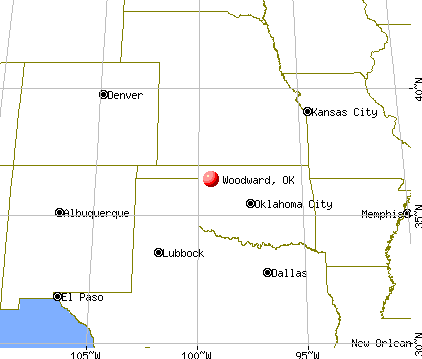
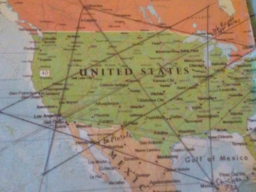
At some point in 2016, I noticed that Woodward, OK, fell on the alignment with: Houston, Dallas, Woodward, Denver, and Edmonton, Alberta. This observation got me wondering about what was in Woodward. It is off the beaten track as far as the National Highway System goes.
I decided to drive up there to check things out – probably about a 2-hour drive from where I lived (on a road which pretty much goes up the alignment – the Northwest Expressway). I saw many ancient features in the landscape on the way, and surrounding Woodward.
Wikipedia indicates that Woodward lies in an oil and natural-gas area on the shelf of Oklahoma’s Anadarko Basin. In 1956, natural gas was discovered in Woodward County. Thereafter, Woodward enjoyed significant growth due to the opening and location of oil field service and drilling companies in Woodward.
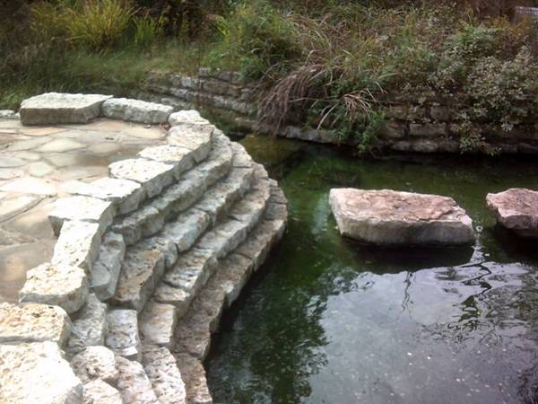
After checking out Woodward, I stopped by Boiling Springs State Park, which is definitely an ancient site, and then after leaving the park, came to Highway 412, and went east towards Enid.
Boiling Springs State Park near Woodward, OK
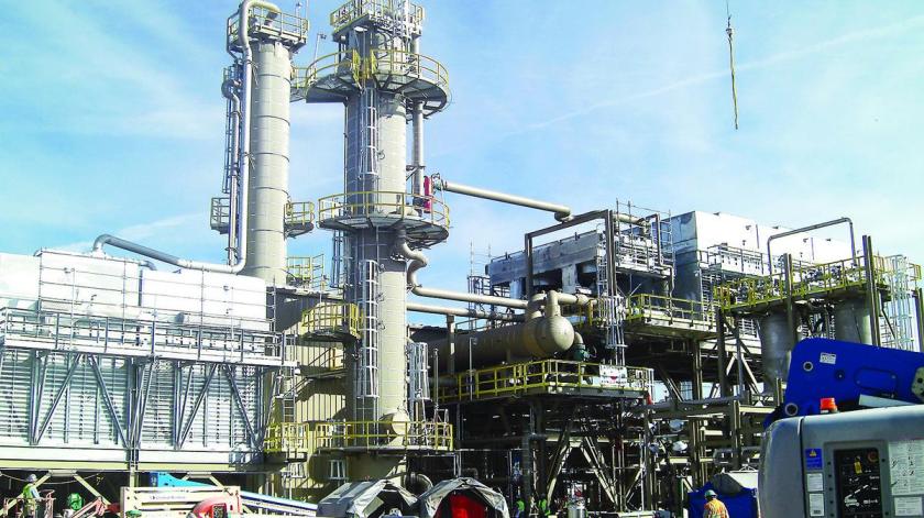
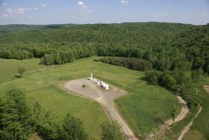
Almost immediately, I came to Mooreland, and saw a facility that looked something like this:
Turns out Mooreland is a hub of the energy industry, including natural gas resources, and connecting energy resources to end-use markets.
I continued driving east on Highway 412 towards Enid, Oklahoma. I am telling you, this was a major thoroughfare of the Ancient Ones. It goes all the way across the top of Oklahoma, and then on into Arkansas. Lots of ancient infrastructure all through there.
All along the way, I saw features in the landscape that looked like these at Gloss Mountains State Park near Enid:
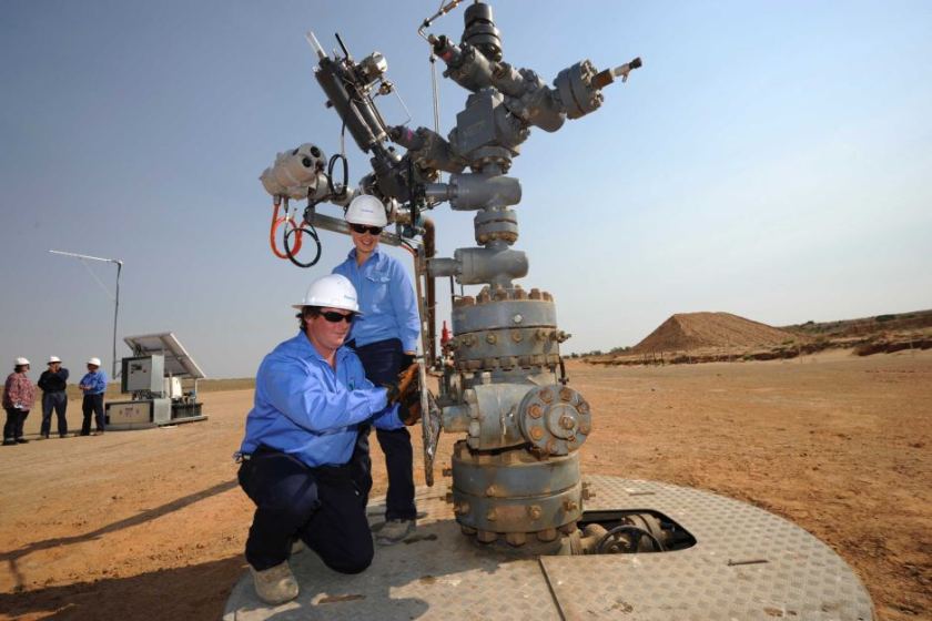
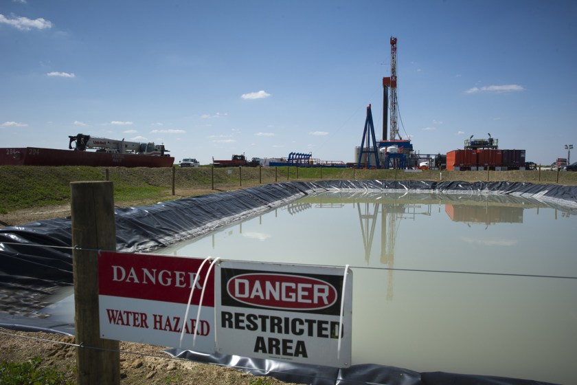
At many places in this drive, I saw what looked like fracking wells in the distance next to these features, like those in other places that are pictured below showing evidence that this is occurring at ancient sites (if it looks like an earthwork, it is an earthwork; the Mound Builders built all earthworks – which is an ancient technology being utilized in the present day):
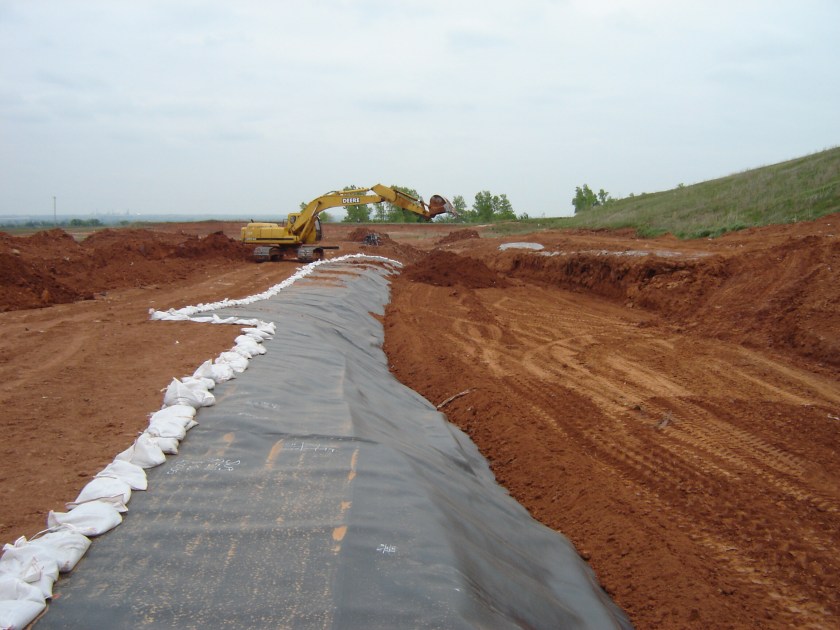
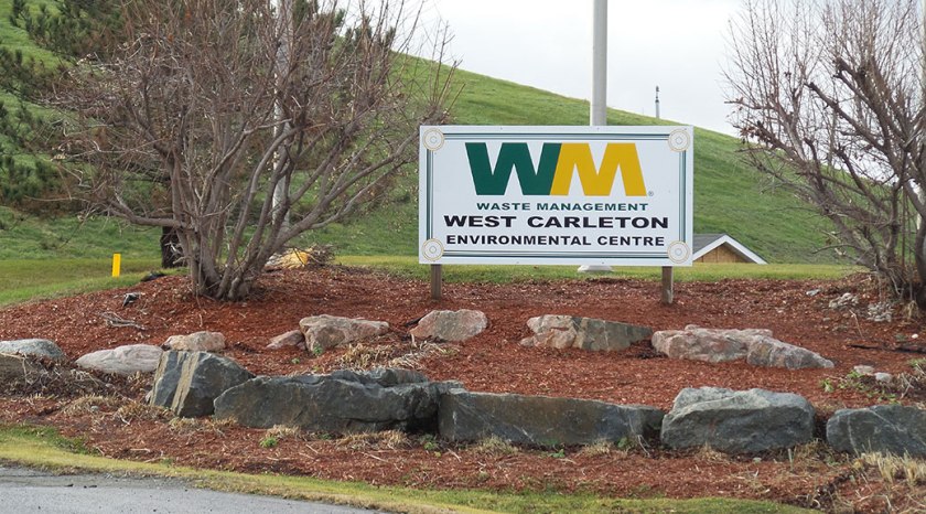
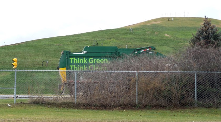
So, this leads me to the subject of landfills. Pictured here on top is the landfill just south of Enid, OK; the bottom two are of the landfill in Stittsville, CA. While I have not been to the one in Stittsville, it is very much like what I saw in Oklahoma.
Please note the ancient stonework displayed around the Waste Management sign for proof this is an ancient site. I have been to the one in Enid, and there are several more in the Oklahoma City area. I did not go there to go to the landfills. I was drawn there because I saw massive ancient infrastructure in the landscape. And they are not just big because of only being comprised of buried trash! In these locations there is typically a Waste Management Facility, and as well as some kind of energy-production related site also on the grounds of these huge structures.
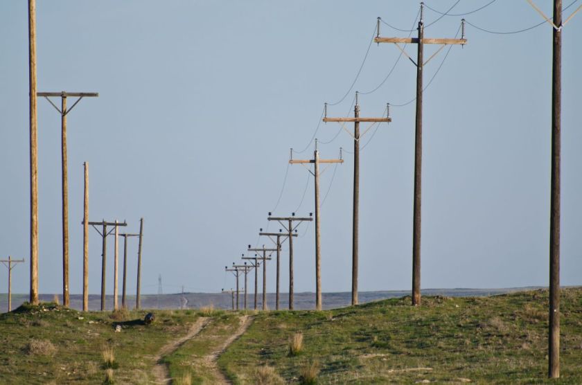
I also saw many, many examples of utility poles being placed on mounds/earthworks. Here is one example, but there many examples once you tune into what is really going on the landscape, i.e. everything is built on top of ancient infrastructure, which the energy industry is all over.
Digital Camera
Digital Camera
Digital Camera
Digital Camera
So, in summary, I am quite convinced based on the examples like these that I have shared with you in this post, and many others that I have seen, there is most definitely a connection between the planetary grid, ancient technology, and our modern energy industry.
I am going to address the issue of the use of the word European to describe white people because there is a lot of evidence out there that this is not a given historically.
or is King James white?
The pictures of King James (King James Version of the Bible King James) are shown as an example of a white-wash.
Several years ago, before I started connecting dots, I read a book by Gary Biltcliffe called the “Spine of Albion.” I was first introduced to his work in this Megalithomania presentation:
He and his partner Carolyn uncovered a North-South line that connected seats of power, that contained 33 nodal points, and they dowsed the male and female dragons of energy that criss-crossed these nodal points, which they named Belinus and Elen. They found out a lot of interesting things as they followed the energy lines.
He is an Intuitive, and dowser, and his journey brought him to uncovering a Cygnus alignment in the British Isles that runs from the Isle of Wight (which is shaped like a coccyx) at the bottom of England to Faraid Head at the tip of Scotland.
I purchased the book several years after seeing the video, and it contains tremendous information. Highly recommend it if you are interested in learning more. One of the things that he mentioned is that they found out (through their dowsing) the Battle of Culloden in 1745 (in which the Jacobite forces of Charles Stuart were defeated by English Loyalists, and after which, following up on the military success won by their forces, the British Government enacted laws further to integrate Scotland – specifically the Scottish Highlands – with the rest of Britain) took place on one of the 33 nodal points.
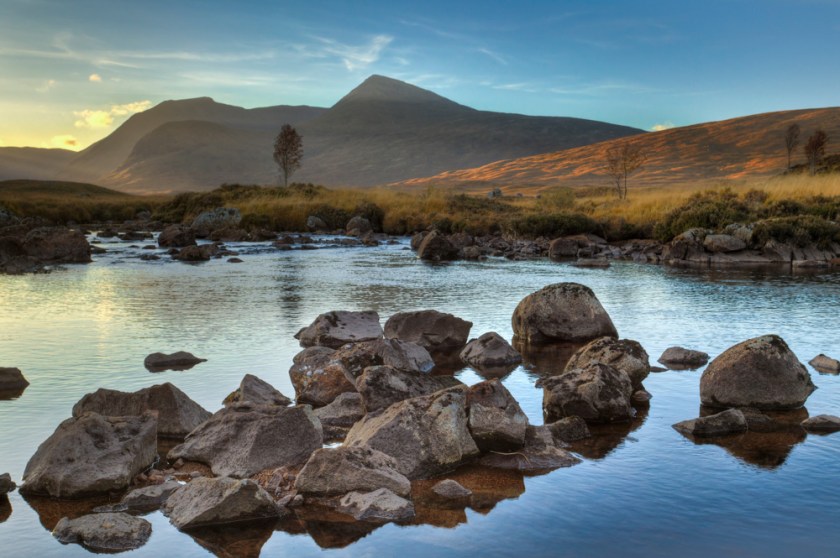
This is a picture of Rannoch Moor in Scotland. Note the block-shaped rocks in the foreground, and the pyramidal shape in the background.
The Moors, as they are called Great Britain are defined as: “An expanse of open, rolling infertile land.”
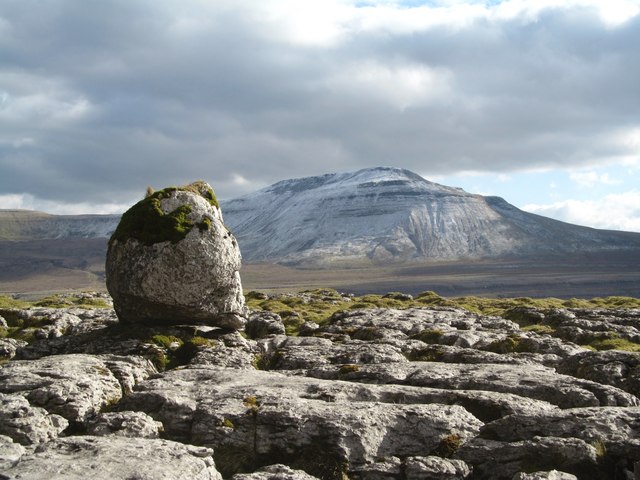
Here is a picture of Scales Moor in Yorkshire:
So what if they are telling you about the actual human Moors…without actually telling you. The geographical Moors I have seen pictures of are covered with massive stones and stone-work.
Same thing with the Ouachita Mountains in Eastern Oklahoma and Western Arkansas. The places are named after the people who lived there.
This picture of King George III of England is out there – you know, the American Revolution King George:
And his wife, Queen Charlotte (who is acknowledged to be a Moor):
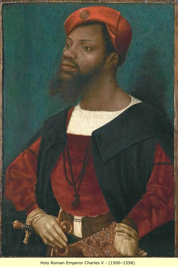
There is also this picture of Holy Roman Emperor Charles V out there in cyberspace:
Okay, so hold on a minute. Say what????
In case you think I am really off-base with this, these links show evidence for a different European history from what we have been taught:
Here is a comparison photo of Ksiaz Castle in Poland (completed in 1292) shown in the second video, with Chateau Frontenac in Quebec City, said to be built for the Canadian Pacific Railway and opened in 1893:
Not an exact match, but I see enough similarity to scratch my head and make me wonder, especially since I have been studying this subject for awhile. Once I really understood who built all the castles, and other buildings, I see the same architectural features in very different places and building types, from castles to private homes.
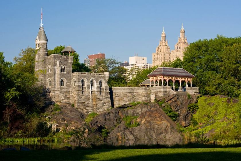
And if you don’t think there are castles in the United States, think again!!! Will do a separate blog on this, but here is a nice example:
Belvedere Castle in Central Park
In the foreground you have ancient stone work; in the middle Belvedere Castle; and in the background you have a building that looks like a Moorish architectural style. But you may say someone built the castle in 1869! I think the castle was there long before 1869, and they just make up stories and put plaques on these castles, and all manner of structures built by the master builders of this land that no one knows were here because they were removed from the historical narrative. I think our history books are completely worthless and in the false narrative, timelines have been shifted from what they actually should be, which would account for Moorish buildings in more modern times.
Back to European Royalty. I learned a lot from Peter Moon, who I learned about from UFO teacher Rick Smith. Both men bring in a lot of information about the Moors, and I will be referring to them occasionally. Probably will give them a blog post. Peter’s work let me to understand the very many rabbit holes associated with the Moors, and I found my own rabbit holes along the way in my own journey to find the Moors.
I bring this up because I learned from him that King Roger II of Sicily was a Moor. His royal mantle was used in the coronation ceremonies of the Holy Roman Emperors. It is in the Imperial Treasury in Vienna, Austria.
Here is a video about the Royal Mantle of King Roger II, and of course the commentators refer to King Roger as a Christian king as they describe the power of the Islamic imagery and symbolism of the mantle.
Now let’s take a comparative look at architecture in Palermo, Sicily and architecture in Morocco:
Palermo, Sicily
Morocco
Not exactly the same, but can we agree on similar?
I would also like to point out that there is an alignment that passes through Sicily – through Messina, Mt. Etna, and Catania. The alignment starts in San Francisco, and passes through the Gilbert Islands, the Caroline Islands, the Phillipines, the Gulf of Tonkin, Myanmar, India, Pakistan, Afghanistan, Iran, Turkey, Greece, the Aegean Sea, Sicily, Malta, Tunisia, Algeria, Mauretania, the Cape Verde Islands, and more countries. See spreadsheet 9 in the grid link above for the full details.
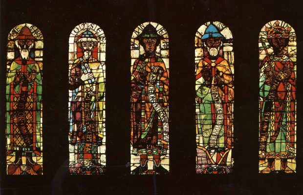
I was in the U. S. Army stationed in Augsburg, Germany, from 1983 – 1985. I was pleased to have an European duty station as I loved European history, and when I was there sought to learn as much as I could about where I was. I had purchased a big picture book about Augsburg with the most famous historical places of interest. So I knew then that the Augsburg Cathedral had the oldest stained glass windows in the world, and that they had been taken into safe-keeping during World War II.
It wasn’t until couple of months ago when I was watching a video that it was brought to my attention that the figures depicted on the stained glass windows of a Christian Cathedral were black….
There are Black Madonnas in Monasteries throughout Europe – Here are a couple of examples:
Montserrat, Spain
Spain
The monastery sits on Montserrat, near Barcelona, and the stones surrounding it are typical of an Ancient infrastructure site. this location also sits on a long-distance alignment, but I know from Gary Biltcliffe’s work that the same Belinus line that goes through Spain and France before it enters England.
The architecture of this monastery in Switzerland has characteristic Moorish signatures of onion domes, massive size and building facade ornamentation.
This is St. Maurice (Moritz), Patron Saint of Germany
The story goes he was an Egyptian and Commander of the Theban Legion in the Roman Army that came to clear the St. Bernard Pass in Switzerland around 287 A.D. where he took a stand against the Emperor Maximian and refused an order to attack fellow Christians, and he and his legion were ultimately killed. He became patron saint of the Holy Roman Emperors in 926. Just leaving this here for consideration in light of everything else I am saying in this post.
I believe that golf courses are specifically related to the cover-up of mound sites.
Why would I believe that?
When I received this map, I started looking up information on the different places shown on the map. I noticed Jekyll Island had a yellow triangle next to it, indicating the presence of an earthen pyramid/mound complex.
When I looked up Jekyll Island Mounds, this is what came up:
Jekyll Island has an interesting history of interest in it by the very wealthy. Even now it is owned by the State of Georgia and run by a self-sustaining, self-governing body. It became a retreat for the very wealthy in the late 1800s, and early 1900s, and was the place where the Federal Reserve System was created in 1910.
I believe mound sites like this have a very special significance in the ancient advanced civilization. Considering that golf is a sport associated with the wealthy and powerful, it would stand to reason that they would re-work these sites for their own purposes, like carving out sand-traps from the mounds of the Ancient Ones. I believe they do this to continue to show dominance over the ancient civilization. I don’t know if all know the truth, but some certainly do. Especially in the upper degrees of Freemasonry, and other elite groups. And members of these groups are in government, and throughout society. They know the truth. And they do everything they can to demean the people they secretly worship. It sounds crazy, but I believe this is true. They have stolen the legacy of human beings of higher consciousness, and pretend to be them while marginalizing and brutalizing them in the worst way.
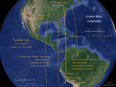
If you are new to this information, and have a hard time with this belief, here’s another powerful example – the Newark Earthworks in Ohio. Newark is a very special place on the planet. As you can see in the one slide, it is located on a Golden Ratio Longitude on the planet, along with other sites, like Poverty Point in Louisiana, and Chavin and Pachacamac in Peru, and Tiwanaku in Bolivia.
You have the same precise geometry and archeoastronomy in earthworks like these in North America that you have in other countries. As a matter of fact, Carl Munck says in his video on “The Code” that there is a correlation between Stonehenge and Newark.
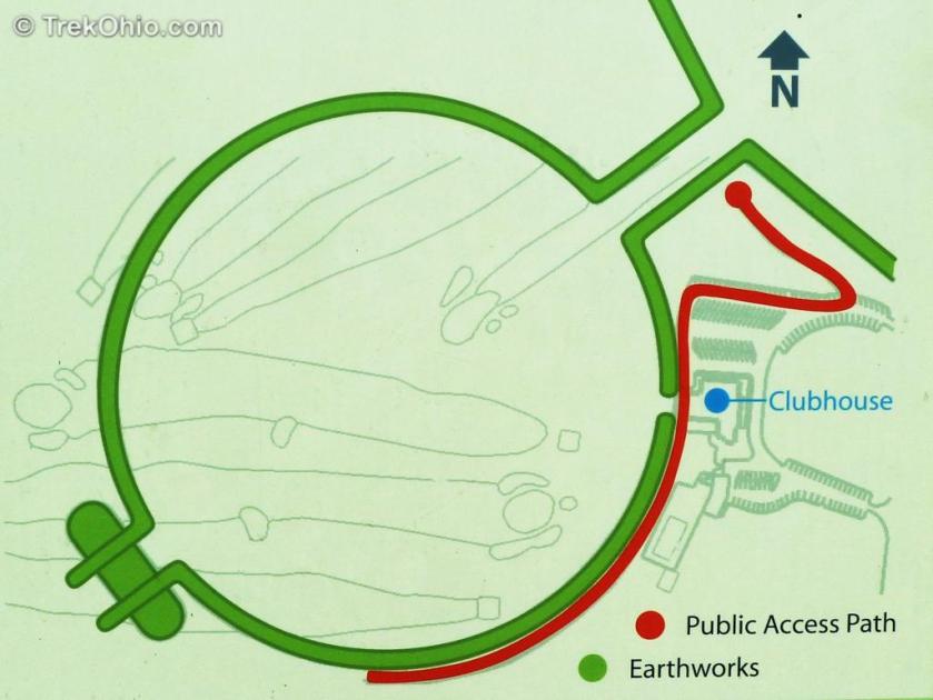
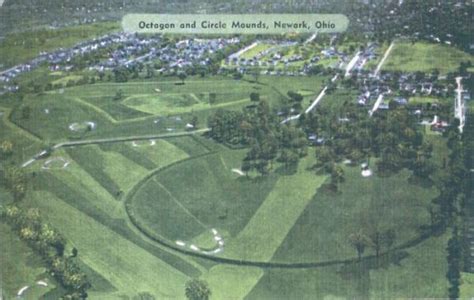
So, building a golf course on to the Newark Earthworks is like building a golf course on Stonehenge. But they did it. These earthworks come into play on eleven of the holes.
Newark Earthworks: Sign showing location of observation deck
Since the historical narrative that we are taught leaves out the true history, known only to a few, no one knows about the abuses that have occurred and still occur. And I will definitely be blogging more about that.
The information that I am going to present to you here came to me in an intuitive, co-creative participatory process. I did feel like I was receiving spiritual guidance in the process, but I had to work for the information I received. It didn’t just come to me in one big download. It seems like to me I had a lifelong experience of collecting puzzle pieces. And when I started to put the puzzle together, I made it happen by visiting many ancient sites, and starting to see what was actually in the environment around me. When I did so, I received even more intuitive guidance. It is not information that I received because I was born into knowing it. Nor did I have any preconceived notions, ideas, or theories about what I was going to find.
The preparation that I had that helped me find all of this was a passionate interest in megaliths, in long-distance alignments discovered by other researchers, and earth mysteries, and knowledge about sacred geometry. I drew my conclusions from what I found after I connected the dots of cities in North America, uncovered the shape of a star tetrahedron, and then extended all of the lines coming off of it around the world. I had to switch to a globe from the map because I was having trouble with determining the earth curvature on the flat map. It is interesting to note that the star tetrahedron appears to be based on 33, 44, and 55 degrees on the map. It fell between 30 – 60-degrees.
Once I switched to the globe, I got a magnifying glass and wrote down the cities that were connecting in circular or linear fashion, and wrote them down in spreadsheets. Then I looked at countless images, and watched hours and hours of drone videos, and I saw the same signature and hand of design, from ancient to modern, all over the planet.
This is one reason why I say there was no place on the planet that this ancient civilization was not, and another is because once I cracked the code of how they managed to cover it up by calling everything natural, and leaving it out of our historical narrative, I literally see it everywhere.
For example, Mt Magazine is called the highest peak in the Ouachita (pronounced Washitaw) Mountains of Arkansas. I first went to Mt. Magazine in September of 2015 on the week-end of the 4th blood moon of the year at the end of the month. I received a lot of intuitive information on this trip.
I had stopped at Heavener Runestone State Park on the way to Mt. Magazine. This location, which is very close to the Arkansas State line, is on the edge of the Ouachita Mountains in Oklahoma. I had been there once before with friends, and stopped by on my way to Mt. Magazine to connect with the energy I had felt there previously. The first time I did not take note of my surroundings at the Runestone. The second time I went there, I noticed that the Runestone was surrounded by an actual wall (which is referred to as a canyon there). The third time I went to Heavener, I took these pictures further up from the Runestone in a different location on the state park grounds.
I am spending time on this sequence of events because this actually marked the beginning of when I started putting all of the pieces of the puzzle together.
I had decided to go to Mount Magazine on the week-end of the 4th blood moon in order to do personal ceremony for myself. Mt. Magazine, according to James Tyberonn, is the location of one of the Atlantean Master Crystals – the Emerald Crystal of Healing. There are two others in Arkansas, one at Queen Wilhelmina State Park, near Mena, Arkansas, and the other at Magnetic Springs, near Eureka Springs, and actually extraordinarily close to the famous Passion Play location. I have visited all three sites.
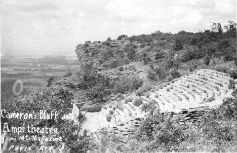
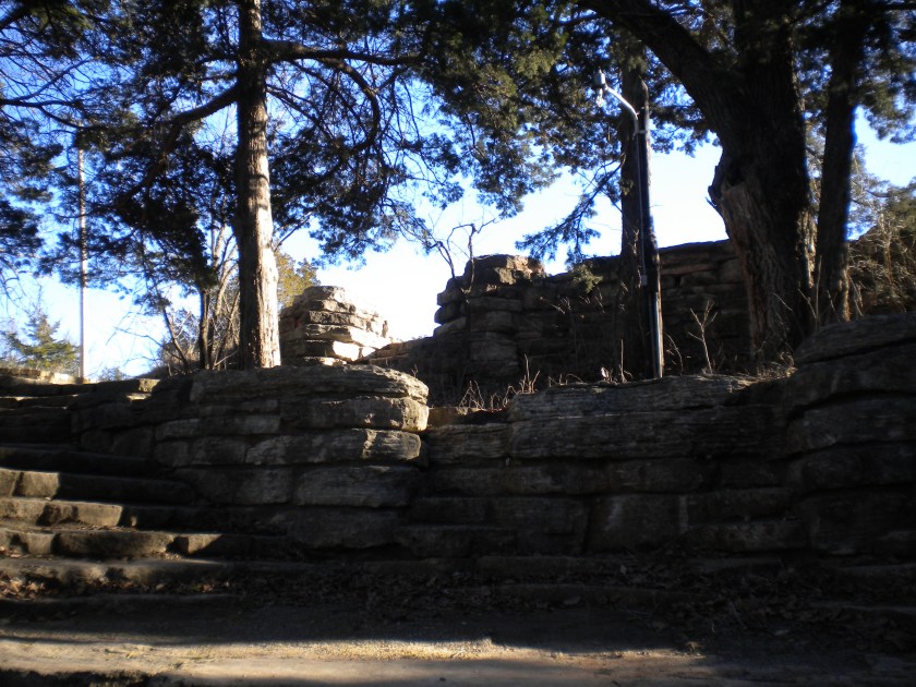
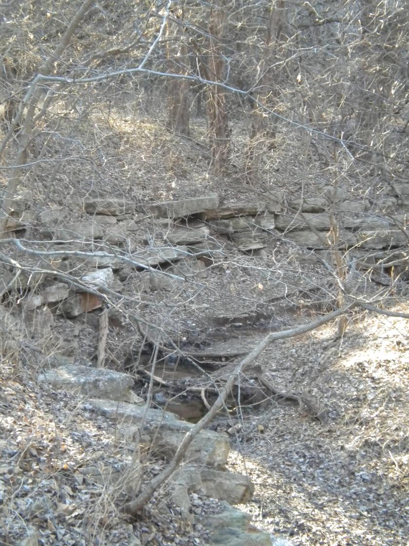
I checked into the Mt. Magazine Lodge. The original lodge was completed in 1940 during the Roosevelt Administration by the Works Progress Administration (WPA). I looked around the lobby, and saw a sign for a tour of “Cameron’s Bluff.” But I had missed it. After getting my luggage to my room, I left the lodge to take my own tour, and find a location for my ceremony. As soon as I took to the turn-off for the road that skirts the bluff, I started seeing a wall again. It is such an ancient wall that there is some element of doubt. But there are some places you can really tell it is a built structure. These pictures were taken of Cameron’s Bluff. Thus began my cracking of the cover-up code – bluffs (and canyons) are actually ancient infrastructure.
It is important to note that the WPA, which built the roads and facilities at the state park, also claimed credit for building an amphitheater in the park.
I am asserting from this example, and many others, the Roosevelt’s New Deal work programs like the WPA, Civilian Conservation Corps (CCC), and Tennessee Valley Authority (TVA) served multiple purposes: 1) To create Depression-era jobs; 2) To build infrastructure; and 3) to cover-up ancient sites/infrastructure. The CCC and WPA in particular were responsible for creating access and infrastructure for the park and recreation system around the country. So when people go to these places, they think that everything they see was created by the CCC & WPA workers. It was NOT. If anything, they used and moved pre-existing materials in the construction, and took credit for building everything.
For example, Roman Nose State Park in Watonga, Oklahoma, was one of many CCC-projects in Oklahoma. I visited there with friends in 2016, and by this time was well on my way to knowing what I was seeing. Roman Nose is a beautiful park. It was named for a Cheyenne Warrior known as Roman Nose. For part of the year they have a teepee set up on the grounds, and we are told that this location was the winter camping grounds for his Cheyenne tribe.
But then when you go to the part of the park that has springs, this is what you find.
The first picture is where you enter the area. There is a restroom, and picnic facilities in several locations:
Then, as you walk on the path that takes by the water, you find that the embankment looks like this:
And the further down the path you go, the more intact you find the stonework:
Until you finally come to this exquisitely peaceful spring:
The stonework pictured is clearly of the same design, and built out in a purposeful way. The CCC operated from 1933 to 1942 in the U.S. for unemployed, unmarried men to help them weather the Great Depression. Originally for young men ages 18–25, it was eventually expanded to ages 17–28. Does it make sense that they could have done the original stone work? It doesn’t. There are other examples, but this example directly relates to my journey of understanding what has actually taken place.
I have a great deal of more information to share with you about many things, but this lays groundwork for many more examples of how an ubiquitous advanced ancient civilization has been covered up right in front of our eyes.
This is my piece of the puzzle. This information was received by me in an intuitive, co-creative process with the Universe because I really wanted to know the truth of who built the megaliths, and it led to all the information I shared in my video and much more. It is clear to me that this information was given to me to bring it to light. Please watch the foundational video on this blog of “Physical Evidence for the Layout of a Planetary Grid System…and a Suppressed Global Civilization.
There is no place on the planet that this civilization is not. Like I said in the video, the evidence is all around us, and below us, and hidden in plain sight. Literally just outside our front doors, in our back yards, in our neighborhoods, in our parks, and road system.
The purpose of this blog is to show you exactly why I believe this, and provide much, much more evidence to support my belief, and information on other related topics. Not knowing this information allows all the many crimes against Humanity, the Planet, and the Creator/Creation to continue unabated because no one knows about it. It has been well-hidden for a reason by those who wish to harm us all for power, control, and energy. Everything is changing, and this information needs to come back out into collective awareness as soon as possible.
I also believe, that up until 500 or so years ago, Humanity was on a positive evolutionary path and in Unity Consciousness, and that around 1492 was the beginning of the hijack of this timeline by dark forces, and the replacement of it with one called Rome. Can’t tell you how this was done, just that it looks like that is what happened because the Ancient Global Civilization built everything on the planet. The same styles/designs cross oceans and continents, from ancient to modern!!!
I am going to start at the beginning of my life, because this is a lifelong pathway that ultimately connected me to the Truth. I wasn’t consciously aware of my spiritual path, and its direct connections to this information, for most of my life. But I was connected to it from the very beginning of my life. I am almost 55-years-old. It has taken me most of that time to put all these puzzle pieces together. Starting this process by telling you about specific moments of awareness in my life journey is ultimately the best way to organize an overwhelming amount of information.
I am from a White, Anglo-Saxon, Protestant (AKA WASP), solidly middle-class family, primarily with roots in the Deep South.
All my known ancestry goes back to the very beginning of what has come to be known as the United States, starting with the Mayflower’s arrival to the so-called Plymouth Bay Colony (I am a direct descendant of William Brewster, a moving force behind the Pilgrims, and the lay religious leader of the Plymouth Colony until the arrival of its ordained minister several years later) to the 1750’s with the influx of the Scots-Irish, my lineage through my maternal grandmother. This is in accordance with the history we have been taught.
It is important to note, that on my Dad’s side of the family, the family history was repeated to my generation as that of the Huguenots. That was all they knew. No elaboration. Just that they were French Huguenots.
Up until recently, the Huguenots were recorded in available historical references as Reformed Calvinists. So the available information not long ago was that for some reason a Protestant Christian sect in France, the Huguenots, were persecuted, and even massacred, for almost 100 years. Come to find out in the Internet Age, the Huguenots were Cathars and Moors.
I grew up in Montgomery County Maryland, outside of Washington, D.C. My first home as a small child was in Rockville. When I was two, my parents moved to Gaithersburg, which is where my earliest conscious memories are. Not any big hits there until much, much later.
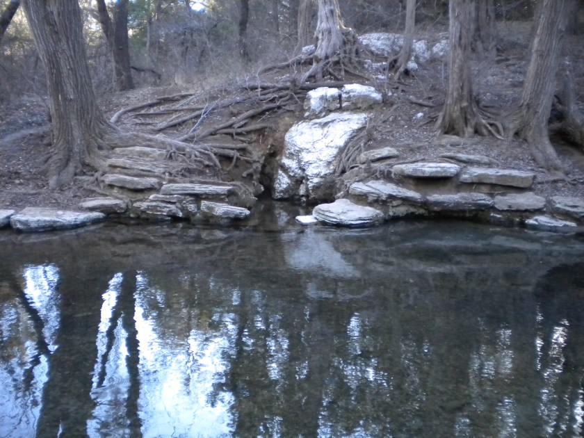
The family church I grew up in was Twinbrook Baptist in Rockville. When I started researching a couple of years ago, I found out that the Twinbrook area is adjacent to Rock Creek.
The softball team, of which my dad, an elementary school teacher and administrator, was a member, practiced at the Meadow Hall Elementary School field, which was right beside the church, just slightly downhill, and was the next street address over on Twinbrook Parkway.
When dad was practicing, and I was young, I, instead of watching the games, I was always down off into the woods, right off the ball field, exploring. It was a really cool place, in more ways than one. What I remember is going down, down into the woods, and eventually finding really big stones to play in. They were really fun for a 6-, 7-, 8-, or whatever-year-old, to play in and around.
This location was close to Lake Needwood and Lake Frank, and both are man-made lakes. I will dedicate a future blog exclusively on the role man-made lakes play related to this subject and the cover-up of it.
In 1974, right after the birth of my youngest brother, we moved to a larger home in Rockville. I always tell people we moved as close to Potomac, Maryland, as my parents could afford. I lived here until 1982, when, after 1 year of junior college, I joined the Army for the Veterans’ Educational Assistance Program. So this is where I grew up.
The house was brand new when we moved in – no trees, and the funny, almost comet-green color of sprayed grass seed.
The reason I bring this up is because the street we lived on – Lindley Terrace – on one end, some of the houses had a steep gradient on the backside – I mean really steep!!! However, the houses were built on a predominantly flat surface. The house my parents bought was on one of the flattest lots on the street. This relates to what I now believe was actually underneath us. Like, a flat-topped pyramid, perhaps? I mean, when I was a kid, for some reason, I really made a mental note of the unusual features of my neighborhood street.
We were literally right next to the boundary fence of the Lakewood Country Club, with a golf tee area right next to the fence. I will be dedicating a specific blog on how golf courses relate to the subject of the cover-up of mounds.
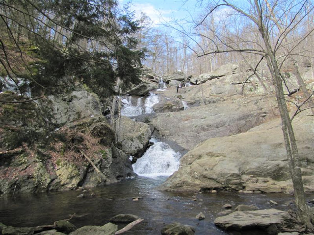
As a family we would go occasionally to Thurmont, Maryland, in Western Maryland, to Cunningham Falls State Park. There was a picnic/swimming area at a lake, and then there were the falls themselves. So I have memories of climbing up the big rocks of the falls. I, like everyone else, had no concept in my awareness, that waterfalls could be anything other than natural. But massive and block-shaped stonework is a recurring feature of waterfalls like what is pictured here. Take a close look at the shape of the rocks in this photo.
Before moving on from Cunningham Falls, it is important to note that Camp David is located in the vicinity. As I learned more about earth grids, I found out that Camp David is situated on a nodal point. It is the norm for centers of power to be on the earth’s power points. There is a reason for this.
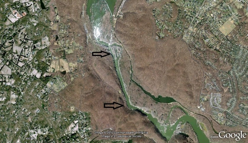
My house was relatively close to Great Falls, Maryland. Access to the falls themselves, at least when I was young, was cut off after Hurricane Agnes went through in 1972. There was access to an area with big stones that was fun to hike and climb, as well as the C & O Canal. So, it was a place I went to many times with family or friends.
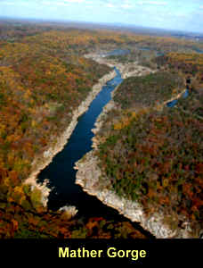
When I started to piece together that waterfalls, and canals as well, were part of the Ancient Civilization, I looked up Great Falls. This is an aerial image of Mather Gorge there. Now, I think the spin is how this could be natural, but look at how straight it is.
And here is how it looks closer to earth….
And then when you realize that part of the ancient civilization involved canal-building (another blog unto itself), then it becomes logical to see this as a canal rather than natural.
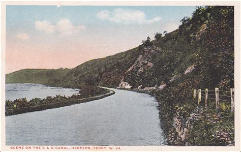
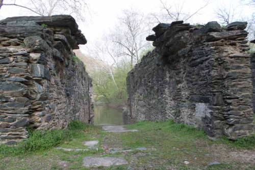
This is a picture of the C & O Canal at Harper’s Ferry. They want us to believe that this was built in the early 1800’s. So, what is wrong with that date of construction? This is a sophisticated engineering project.
As a matter of fact, the C & O Canal parallels the Potomac River through this area for a long distance. What technology existed in America in the late 1700s/early 1800s could have built a sophisticated project like this? I am not aware of any technology that existed at that time that could have built something like this. According to our history books, the second Industrial Revolution didn’t begin in the U.S. until the mid-1800s.
My conclusion is that the C & O Canal, as well as the Erie Canal, and the St. Lawrence Seaway, and a canal system that covered the continent, was built by the advanced ancient civilization that was long-established here when the Europeans first arrived. Again, when I say ancient, I mean a very old civilization that was living and flourishing in North America (and South America) when the Europeans first arrived. And I have much more to say about the use of the word European to describe white people in a later blog based on my findings. This ancient civilization was global!


![Pontcysyllte-Aqueduct-0[3]](https://i0.wp.com/piercingtheveilofillusion.com/wp-content/uploads/2018/06/pontcysyllte-aqueduct-03.jpg?w=324&h=432&ssl=1 "Pontcysyllte-Aqueduct-0[3]")