Seeing World History with New Eyes – 1987 to 1989

In this series “Seeing World History with New Eyes,” I have looked at events that have taken place in our historical narrative in the years between 1945 and 1986.

I am giving an overview of modern history with an eye towards uncovering the patterns that give insight into the world we live in today.

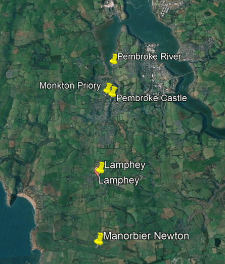
I am going to look at what took place between 1987 and 1989 in this post.

Now let’s see what happened in the year of 1987.

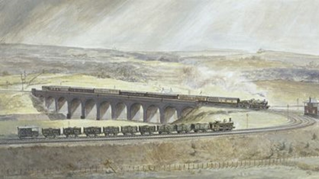
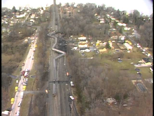
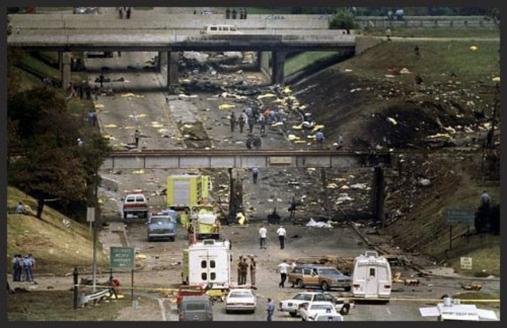
On January 4th, an Amtrak train en route from Washington to Boston crashed into a set of locomotives without freight cars that weren’t supposed to be on that line at Chase, Maryland, in eastern Baltimore County, killing 16.

At the time of the collision the Amtrak train was travelling at a speed of 108 mph, or 174 kmh.

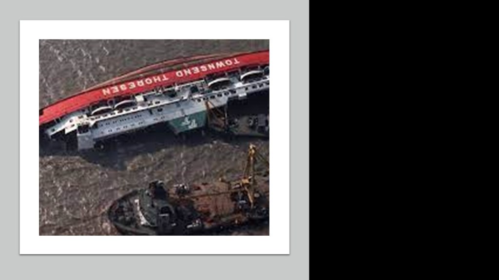
The roll-on/roll-off cross channel ferry MS Herald of Free Enterprise capsized off Zeebrugge Harbor in Belgium on March 6th, killing 193.

The 8-deck car and passenger ferry was designed for rapid loading and unloading, and had no watertight compartments.

The ship left the harbor with her bow door open, and the sea immediately flooded the decks.

Within minutes, the vessel was lying on its side in the water.

The cause was attributed to a boatswain that was sleeping when he should have been closing the bow door.

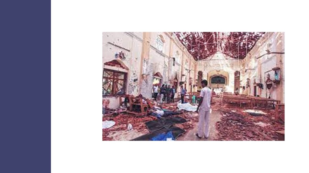
On April 21st, the Central Bus Station bombing took place in Colombo, Sri Lanka, and killed 113 civilians.

It was a terrorist act attributed to the Tamil Tigers.

LOT Polish Airlines Flight 5055 crashed into a forest just outside Warsaw on May 9th, killing all 183 people on-board.

It was the deadliest aviation disaster in Polish history, and the cause was determined to be the disintegration of the engine shaft due to faulty bearings, leading to an uncontained engine failure and on-board fire.

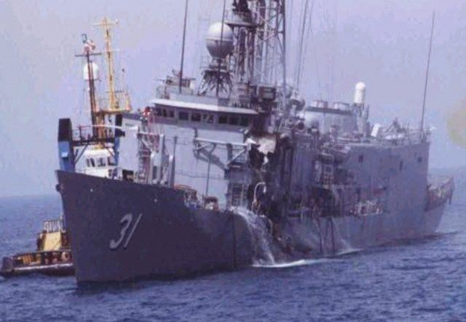
On May 17th, the USS Stark was hit by two Iraqi-owned Exocet air-to-surface missiles, killing 37 sailors, and injuring 21.

The naval vessel was part of a Middle East Task Force patrolling off the coast of Saudi Arabia near the Iran-Iraq Exclusion Zone during the war between those two countries.

The Hashimpura Massacre occurred on May 22nd in Meerut India.

It involved 19 members of the Provincial Armed Constabulary rounding up 42 Muslim youths from the Hasimpura village in Meerut, taking them to the outskirts of the city, shooting them, and leaving their bodies in an irrigation canal.

On March 21st of 2015, the men accused of committing the massacre were acquitted on the basis of insufficient evidence.

But then on October 31st of 2018, a higher court overturned that decision, and the men were sentenced to life imprisonment.

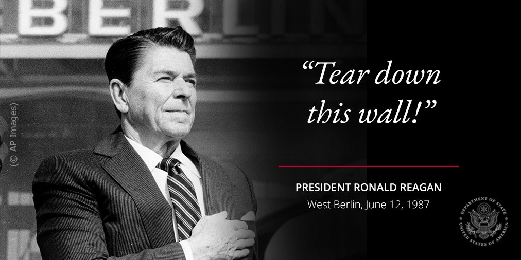
During a visit to West Berlin in a speech in front of the Brandenburg Gate, President Reagan challenged Soviet Premier Mikhail Gorbachev to tear down the Berlin Wall on June 12th.

The Hipercor bombing took place on June 19th, in which the Basque Terrorist Group ETA perpetrated a car-bomb attack at Hipercor market in Barcelona, killing 21, and injuring 45.

It was the deadliest act in the history of ETA.

The damage at the scene was so extensive that several of the bodies could not be located until hours later and some burned so severely that they could not be identified.

On June 27th, Philippines Airlines Flight 206 crashed into a mountaintop near Baguio, Philippines, killing all 50 people on board.

The cause of the crash was attributed to bad weather at the time.

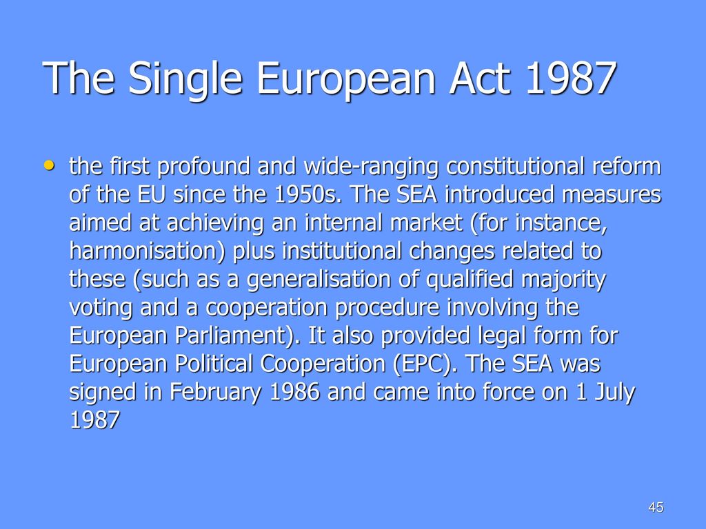
The Single European Act came into effect on July 1st, with European Economic Communities committing themselves to removing all remaining barriers to a common market by 1992.

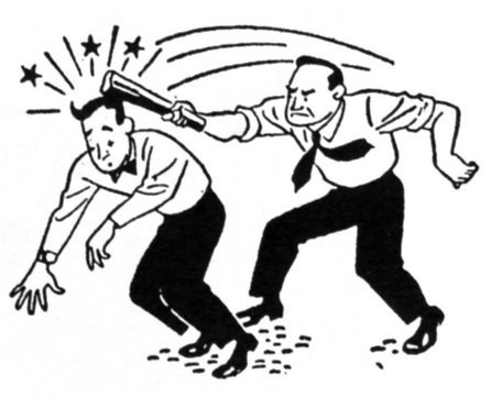
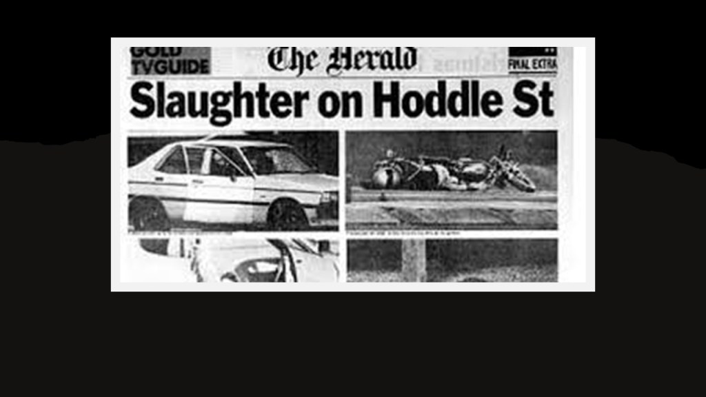
On August 9th, the Hoddle Street Massacre in Clifton Hill, Victoria State, Australia, took place when a 19-year-old went on a shooting rampage in this suburb of Melbourne, killing 7 and injuring 19.

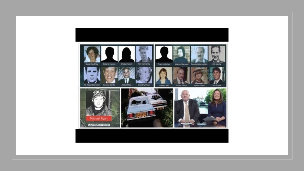
Then ten-days later, the Hungerford Massacre took place on August 19th, in which 27 people died in Britain’s first mass shooting, carried out by 27-year-old antiques dealer and handyman Michael Ryan.

Northwest Airlines flight 225 crashed shortly after take-off from Detroit Metropolitan airport on August 16th, killing all but one of the 156 people on board, a four-year-old girl who sustained serious injuries.

The cause of the crash was attributed to pilot error, mismanagement of aircraft and confusion.

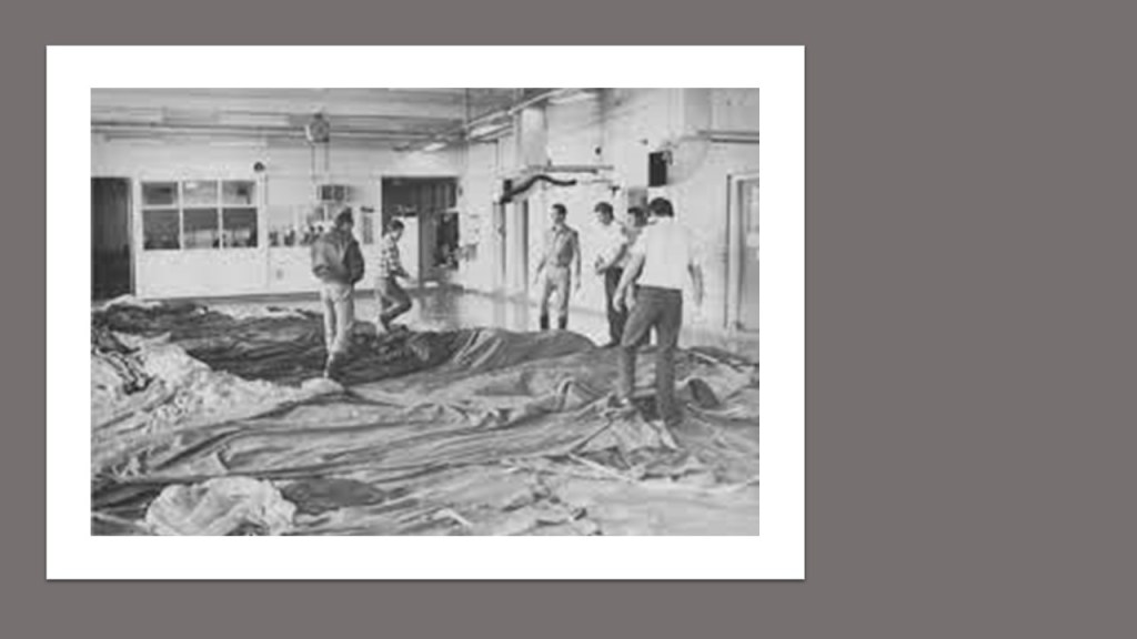
On September 13th, the Goiania accident took place, in which metal scrappers removed an old radiation source from an abandoned hospital in Goiania, Brazil, and caused the worst radiation incident ever in an urban area.

It was subsequently handled by many people, and resulted in four deaths.

Of the 112,000 people tested for radioactive contamination, 249 were found to be contaminated.

Top-soil had to be removed from several sites in the clean-up, and several houses were demolished.

All objects from within those houses were seized and incinerated.

Black Monday Stock market levels fell sharply on October 19th in all of the 23 major world markets. Worldwide losses were estimated at USD $1.71 trillion.

Despite fears of a repeat of the Great Depression, the market rallied immediately after the crash, gaining 102.27 points the next day, and 186.64 on October 22nd. It took two years for the market to recover completely.

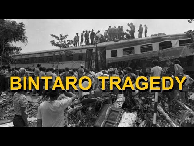
On October 19th, two commuter trains collided head-on in what was known as the Bintaro train crash in West Java, Indonesia, killing 102.

The cause was attributed to human error.

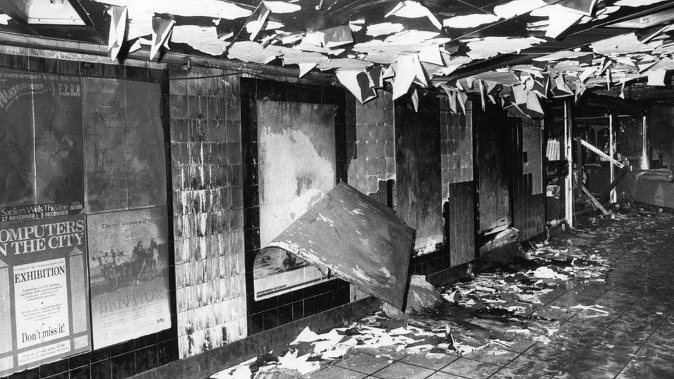
The King’s Cross Fire in the London Underground at the King’s Cross St. Pancras tube station killed 31 people and injured 100 on November 18th.

The fire started under a wooden escalator serving the Piccadilly Line and erupted in a flash-over into the Underground ticket hall.

Investigators determined that the cause of the fire was a lit match that had been dropped from the escalator that intensified suddenly what was called the previously unknown”trench effect,” a combination of circumstances that can rush a fire up inclined surfaces.

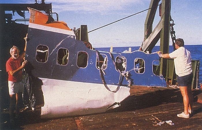
On November 28th, South African Airways Flight 295 crashed into the Indian Ocean off the coast of the Island Republic of Mauritius due breaking-up in mid-air because of a fire in the cargo hold, killing all 159 people on the plane. The cause of the fire was never determined.

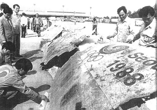
The next day, on November 29th, Korean Air Flight 858 was blown-up over the Andaman Sea, killing all 115 people on-board with North Korean agents taking responsibility for the bombing.

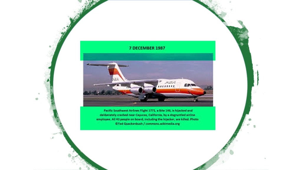
Then on December 7th, Pacific Southwest Airlines Flight 1771 crashed near Paso Robles, California, after a disgruntled employee shot his former supervisor on the flight, and then he proceeded to shoot both of the pilots.

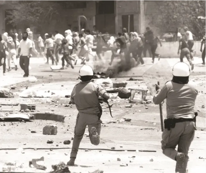
The First Intifada began in the Gaza Strip and West Bank between Palestine and Israel on December 8th.

The first intifada was a sustained series of Palestinian protests and violent riots against the Israeli occupation of Gaza and the West Bank since 1967.

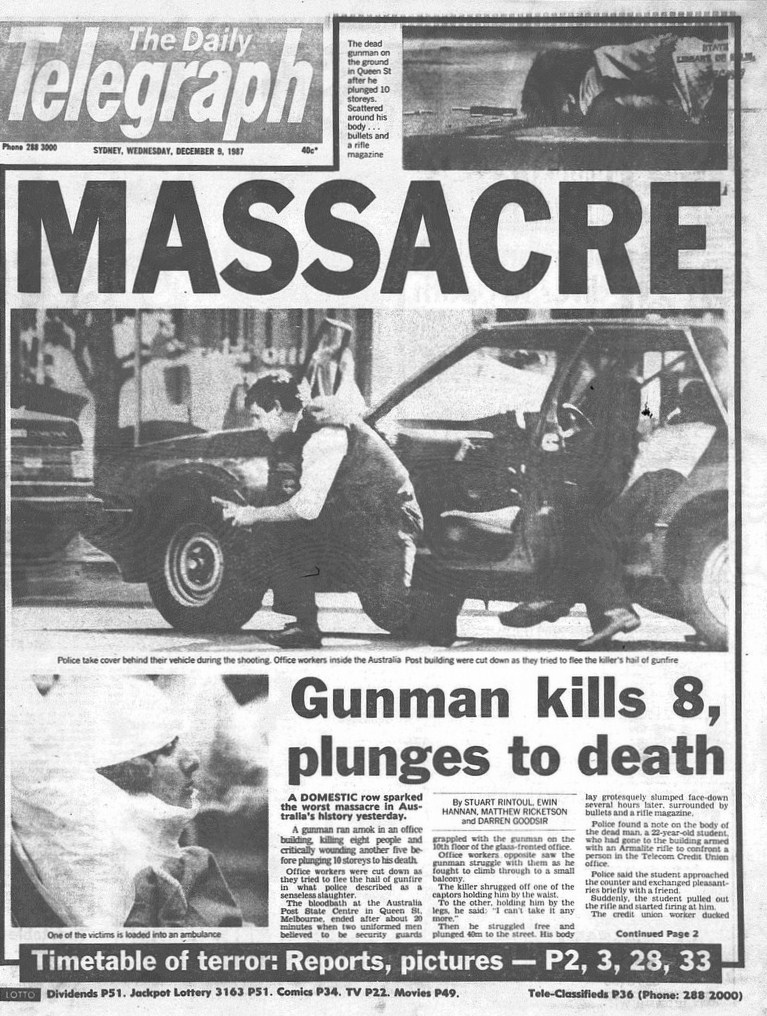
On the same day of December 8th, the Queen Street Massacre took place in Melbourne, Australia, involving a 22-year-old shooter who killed 8, injured 5, in a post office, then committed suicide by jumping from the 11th-floor.

Microsoft released Windows 2.0 on December 9th.

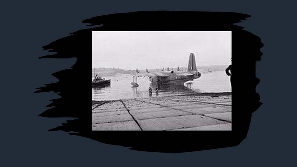
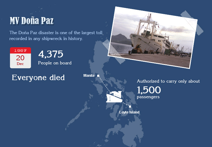
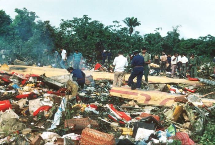
In the world’s worst peacetime sea disaster on December 20th, the passenger ferry MV Dona Paz sank after colliding with the Oil Tanker Vector 1 in the Philippines, believed to have killed an estimated 4,375 people.

So what happened in 1988?

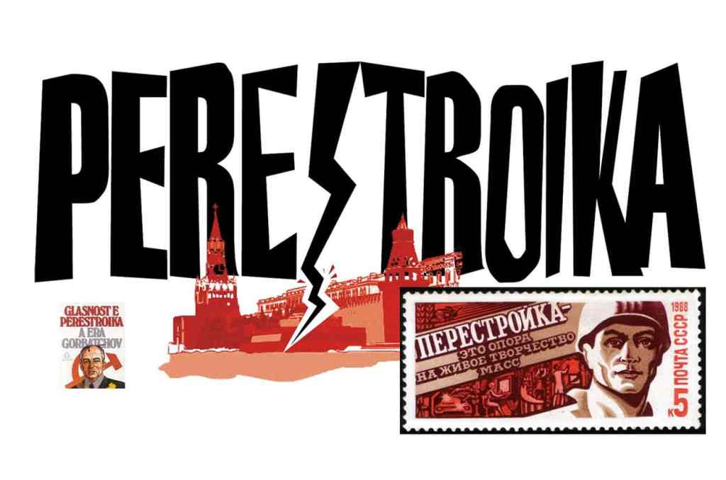
On January 2nd, the Soviet Union began its program of economic restructuring known as Perestroika, a political movement for reformation within the Communist Party, and Glasnost, meaning “openness.”

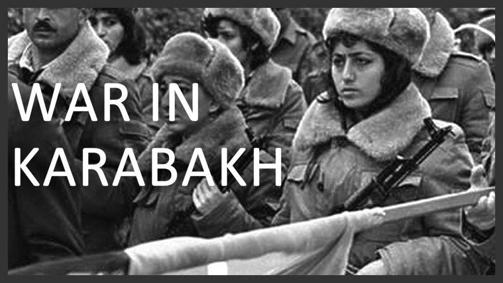
The Nagarno-Karabakh Autonomous Oblast voted to secede from the Azerbaijan Soviet Socialist Republic on February 20th and join the Armenian Soviet Socialist Republic, marking the beginning of the First Nagarno-Karabakh War.

This was significant because it marked the start of the collapse of the Soviet Union, and its process of internal disintegration with growing unrest in its constituent republics.

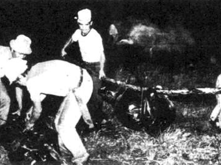
The Halabja Chemical Attack was carried out on March 16th by Iraqi government forces towards the end of the Iran-Iraq War, the largest chemical weapon attack against a civilian-populated area in history, resulting in the massacre of up to 5,000 Kurdish people, and injuring up to 10,000.

It took place 48-hours after the town was captured by the Iranian Army in Iraqi Kurdistan.

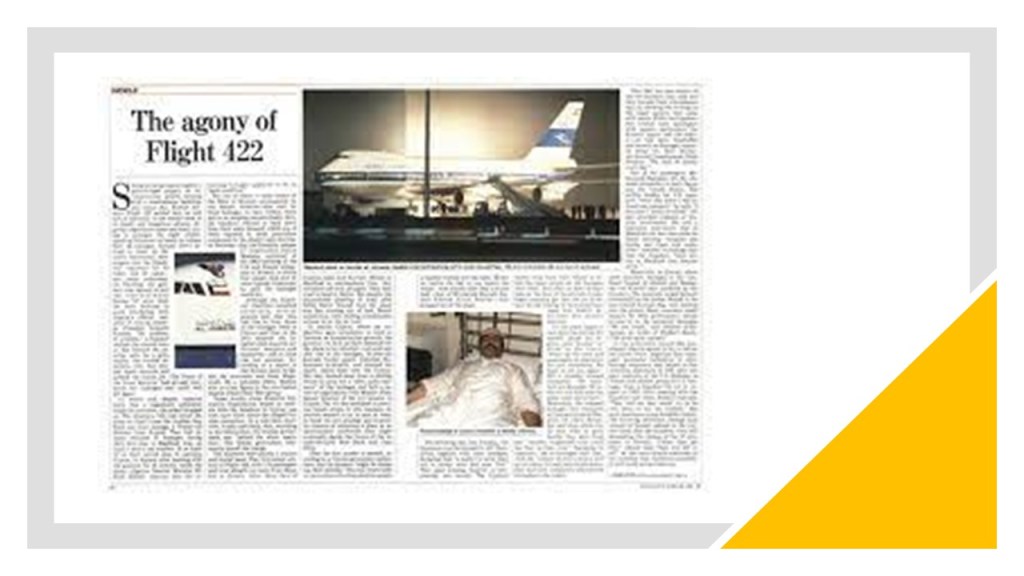
On April 5th, Kuwait Airways Flight 422 was hijacked while en route for Bangkok, Thailand to Kuwait, with the hijackers demanding the release of 17 Shiite Muslim prisoners held by Kuwait, and Kuwait refused to do so.

This led to a 16-day siege across three continents, and the death of two passengers.

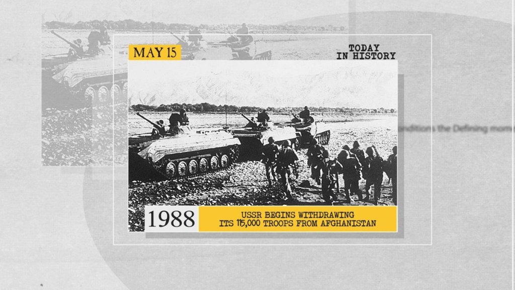
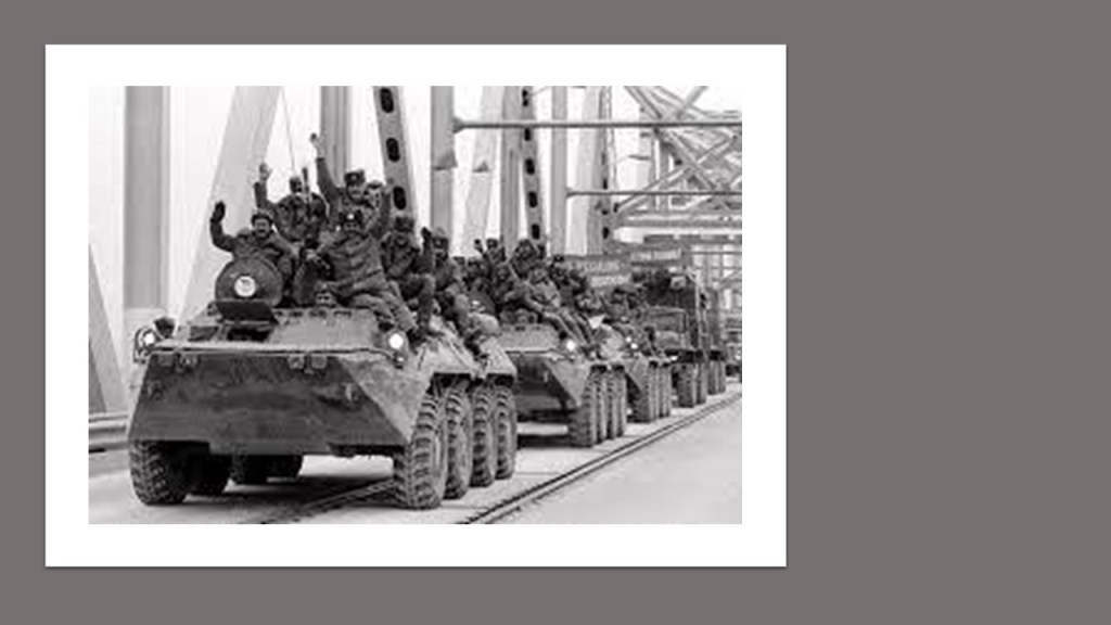
After eight years of fighting, the Soviet Army began its withdrawal from Afghanistan on May 15th.

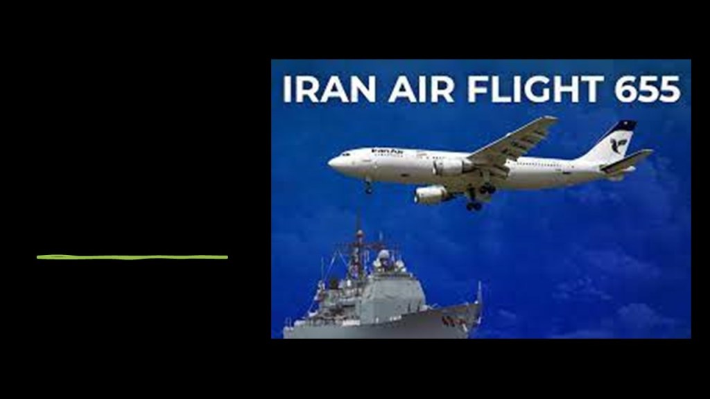
Iran Air Flight 655 was shot-down by a missile launched from the USS Vicinnes on July 3rd, killing 290 people on-board.

The reason for the downing of the plane has been disputed by the governments of the two countries.

According to the United States, the Vicinnes crew had identified the airbus as an Iranian Air Force jet fighter.

According to Iran, the plane was negligently shot down. in 1996, the two governments reached a settlement in the International Court of Justice, in which the United States recognized the incident as a terrible human tragedy, and expressed deep regret over the loss of lives, but did not admit to legal liability or formally apologize to Iran, and instead agreed to pay $61.8 million on a voluntary basis in compensation to the families of the Iranian victims.

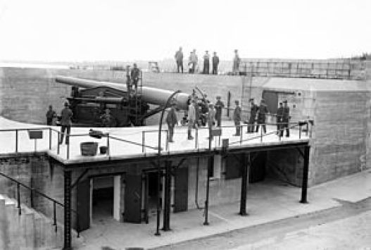
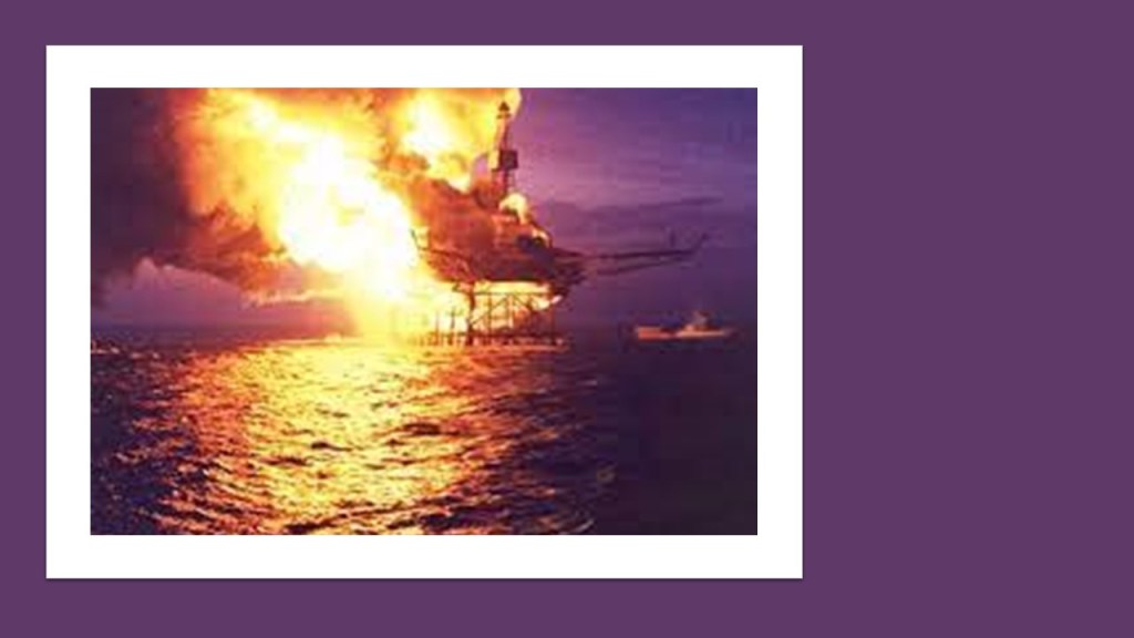
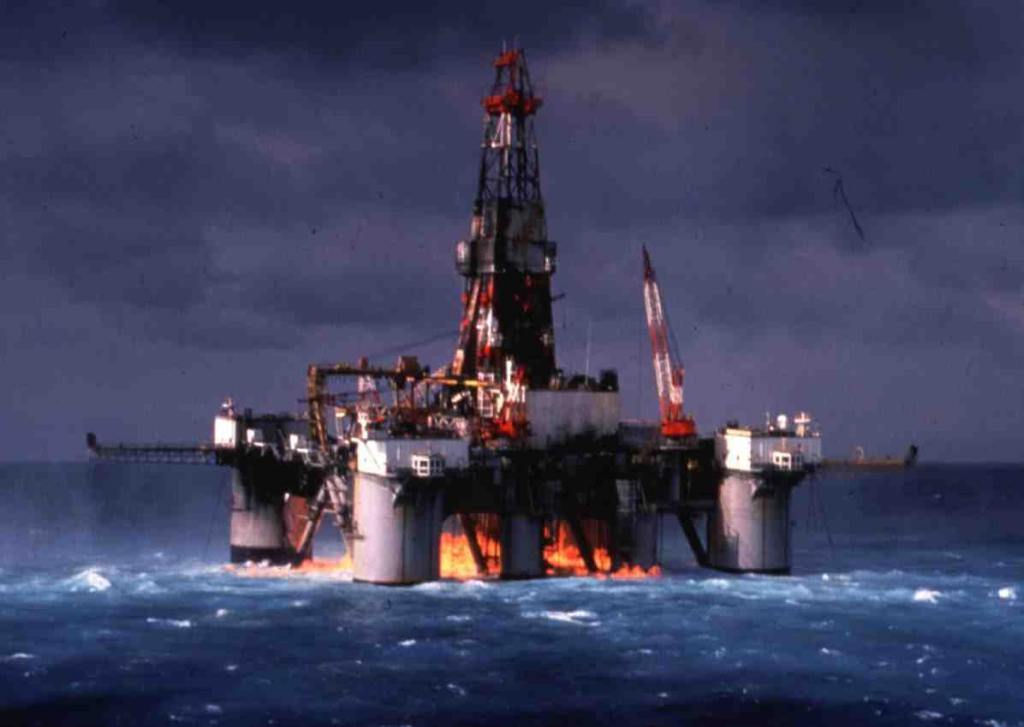
On July 6th, the Piper Alpha oil production platform in the North Sea northeast of Aberdeen, Scotland, was destroyed by explosions, killing 167 people.

The accident was the worst offshore oil disaster in terms of lives lost and industry impact.

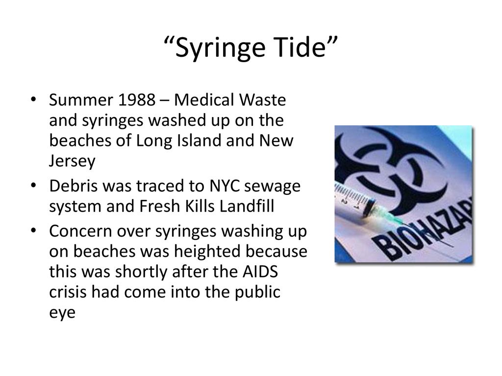
The first reported medical waste on beaches in the Greater New York area washed ashore on Long Island on July 6th.

Known as the “Syringe Tide,” it included hypodermic needles and syringes possibly infected with the AIDS virus, with subsequent discoveries of the same medical waste on Coney Island, Brooklyn, and Monmouth, New Jersey.

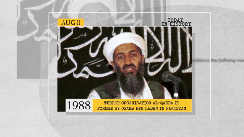
Al-Qaeda was founded by Osama Bin Laden on August 11th, a network of Islamic extremists and jihadists with the long-term goal of creating a unified and global caliphate.

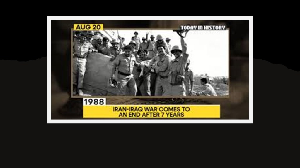
On August 20th, a cease-fire ended the Iran-Iraq War, with an estimated million lives lost.

Just a little over two-months after the Piper Alpha disaster, on September 22nd, a second oil production platform in the North Sea, the Ocean Odyssey, suffered a blow-out and a fire, resulting in 1 death and 66 survivors rescued.

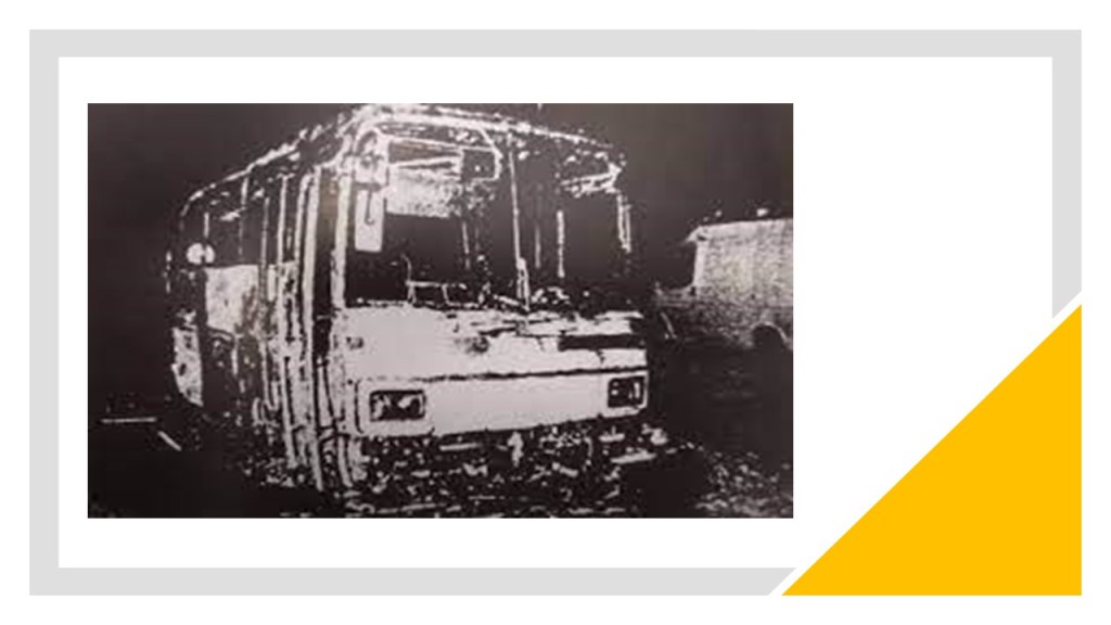
The Jericho Bus fire-bombing took place on October 30th, with 5 Israelis killed and 5 wounded, in a Palestinian attack in the West Bank.

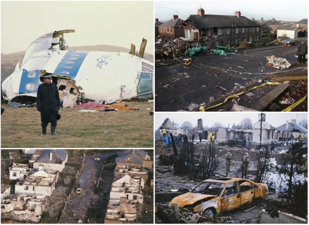
On December 21st, Pan Am Flight 103 was blown-up in mid-air, with wreckage falling onto a residential street in Lockerbie, Scotland, killing 270 people, including 11 people on the ground.

After a three-year investigation by Scottish and American authorities, arrest warrants were issued for two Libyan Nationals in November of 1991.

Muammar Qaddafi handed over the two suspects after protracted negotiations and UN sanctions.

Only one of the two men was sentenced for the bombing, to a life sentence, after being found guilty of 270 counts of murder in connection for the bombing.

 He was released from prison on compassionate grounds in 2009 because he was diagnosed with prostate cancer, and died in 2012.

The last year in this part of the series is 1989, a significant year in my life – college graduation, marriage, and a major move from the East Coast to the Southwest of the United States.

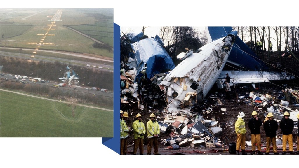
On January 8th, British Midlands Flight 92 crashed on the motorway embankment between the M1 motorway and A435 Road near Kegworth while attempting to make an emergency landing at East Midlands Airport, leaving 47 dead and 74 with serious injuries.

The cause of the crash was identified as the failure of one engine followed by the erroneous shut-down of the other engine by the pilot.

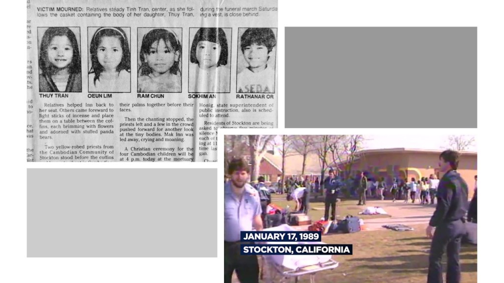
The Stockton Schoolyard Shooting occurred at the Grover Cleveland Elementary School in Stockton, California on January 17th, in which 5 children were killed, 30 wounded.

The gunman, Patrick Purdy, committed suicide as first responders were arriving on the scene.

This shooting took place almost ten years to the day after a school shooting in San Diego, also at an elementary school named after Grover Cleveland, which happened on January 29th of 1979.

The Soviet-Afghan War ended on February 2nd after nine years of conflict.

The conflict was a Cold War-era proxy war, in which the Soviet Union and the unpopular & repressive government of the Democratic Republic of Afghanistan, which was Soviet-backed, fought in a guerilla-style war against insurgent groups like the Muhajadeen and smaller Maoist groups backed by Pakistan, Iran, Saudi Arabia, China, the United Kingdom and the United States.

Between 500,000 and 2,000,000 civilians were killed and millions of Afghans fled the country as refugees as a result of the Soviet-Afghan War.

On March 4th, a rail collision between two trains occurred just to the north of the Purley Railway Station in the London Borough of Croydon, leaving 5 dead and 88 injured.

As one of the trains left the station, it crossed from the slow lane to the fast lane as scheduled, and was struck from behind.

The train driver responsible for the collision “passed a signal at danger,” which was the equivalent of running a red light.

He pled guilty to manslaughter, and served four months of a 12-month sentence with six-months suspended.

Tim Berners Lee produced the proposal document that would become the blueprint for the World Wide Web on March 13th.

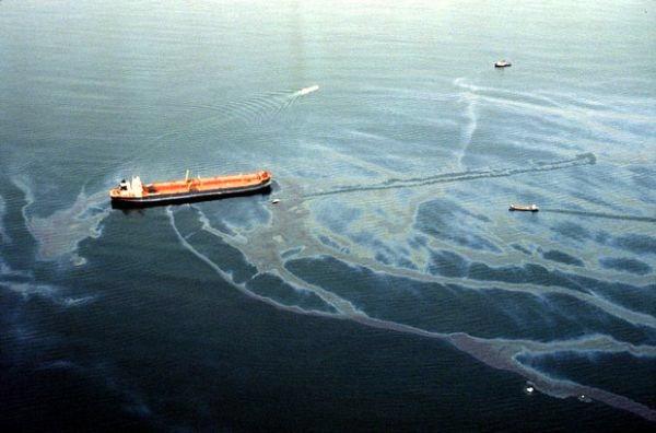
The Exxon Valdez Oil spill took place in Alaska on March 24th.

The Exxon Shipping Company-owned oil tanker bound for Long Beach, California, struck Bligh Reef in the Prince William Sound and spilled 10.8-million gallons of crude oil over the next few days.

It was considered the world’s worst environmental disaster.

The oil spill eventually affected 1,300-miles, or 2,100-km, of coastline, of which 200-miles, or 320-kilometers, were heavily-, or moderately-oiled.

A cause I remember being cited at the time of the disaster was that the tanker’s captain had been drinking heavily that night, but he accused Exxon of trying to make him a scapegoat, and he was cleared at his 1990 trial after witnesses testified he was sober around the time of the accident.

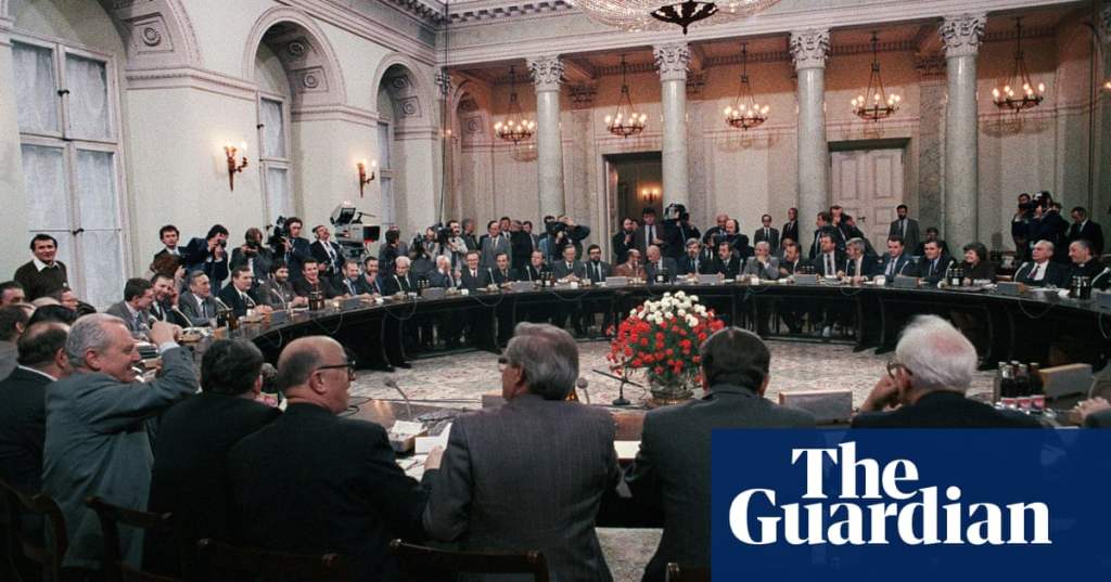
On April 5th, the Polish Government and the Solidarity trade union signed an agreement restoring Solidarity to legal status as a result of the Polish Round Table Talks, and to hold democratic elections on June 4th, which initiated the 1989 revolution and the overthrow of Communism in Central Europe.

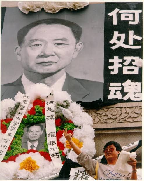
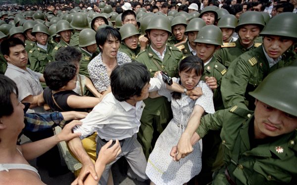
The death of former Communist Party General Secretary and economic reformer Hu Yaobang in China on April 15th after a fatal heart attack sparked the beginning of the Tiananmen Square protests, when more than 100,000 students took to the streets of Beijing to mourn him and called for a more transparent system and an end to corruption.

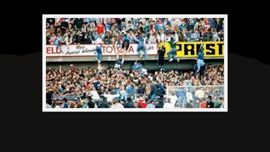
The Hillsborough Disaster also took place on April 15th, one of the biggest tragedies in European football.

It was a fatal human crush that took place during a football match between Liverpool and Nottingham Forest at Hillsborough Stadium at Sheffield, South Yorkshire in England.

Apparently in an attempt to ease overcrowding at the entrance turnstiles before the kick-off, the police match commissioner ordered the exit gate “C” opened, leading to an influx of even more supporters into the two standing-only pens allocated for the Liverpool Football club supporters.

This led to a crowding in the pens and the crush, which resulted in 96 deaths and 766 injuries.

While the Taylor Report of 1990 found the main cause of the disaster was failure of control by the South Yorkshire Police, the Director of Public Prosecutions ruled there was no evidence to justify prosecutions of any individuals or institutions.

The main future safety outcome was the elimination of fenced standing terraces in favor of all-seater stadiums in the top two tiers of English football.

The San Bernadino train disaster was a combination of two separate but related incidents that occurred in San Bernadino, California. The first was a runaway Southern Pacific freight locomotive derailment on an elevated curve and plowed into into a residential area on Duffy Street. The conductor, head-end brakeman, and two residents were killed in the crash.

The second-related incident was the failure of the Calnev pipeline that was damaged during the rail-crash clean-up, causing it to explode on May 25th, killing two more people and destroying 11 more houses and 21 cars.

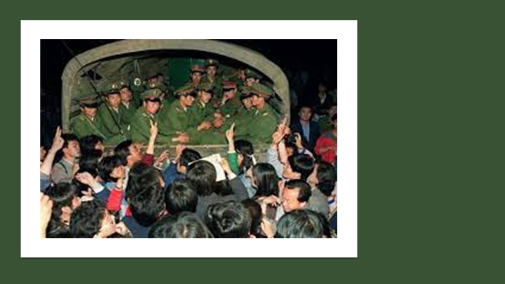
More than 1,000,000 Chinese protestors marched through Beijing between May 14th and 17th demanding greater democracy, leading to a crack-down.

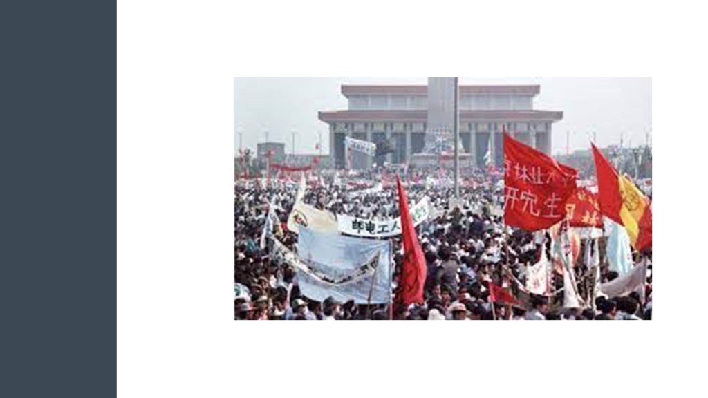
The Chinese government declared martial law in Beijing on May 20th.

I graduated from the University of Maryland Baltimore County on June 3rd with a Bachelor’s Degree in Social Work and Psychology, with an emphasis on Geriatric Social Work, and I was a Geriatric Social Worker and Activities Professional for 13 years, primarily in a long-term-care and skilled nursing facility setting.

I got out of this field permanently in 2003.

On June 4th, a crackdown took place in Beijing as the army approached the square, and the final stand-off was covered on live TV.

In Poland on June 4th, Solidarity’s victory in the elections was the first of many anti-communist revolutions in 1989 in Central and Eastern Europe.

An unknown Chinese protestor stood in front of a column of military tanks in Tiananmen Square on June 5th, temporarily halting the tanks.

The incident took place on the morning after Chinese troops fired upon pro-democracy students who had been protesting in the square since April 15, 1989.

On June 7th, Surinam Airways Flight 764 originating from the Netherlands crashed in Paramaribo, Surinam, killing 178 of the 187 people on board, and the deadliest aviation disaster in Surinam’s history.

We are told that the accident was the result of pilot error stemming from significant deficiencies in the crew’s training and judgment.

Some members of the Surinamese football team playing professionally in the Netherlands known as the “Colorful 11” were among the dead.

I married U. S. Army Retired Sergeant Dave Gibson on June 10th of 1989 in front of all my family and friends, and forever changed the course of my life and ultimately getting me to the place of awareness where I am today.

The following day, I moved from the Baltimore-Washington area forever to Clovis, New Mexico, with my new husband, the nearest place to his family in Hereford, Texas, with a military installation at Cannon Air Force Base.

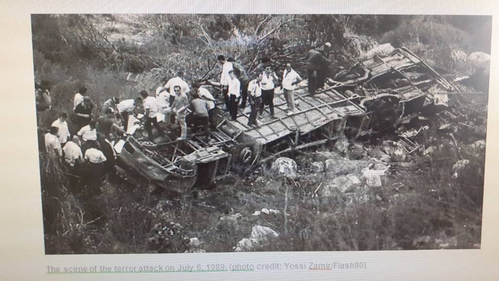
The Tel Aviv Jerusalem Bus 405 suicide attack, the first Palestinian suicide attack on Israel, took place on July 6th by a member of the Palestinian Islamic Jihad.

The attacker seized control of the steering wheel of the bus, and drove it off a steep ravine.

Ironically, the suicide attacker survived, along with 27 others, but sixteen people did not.

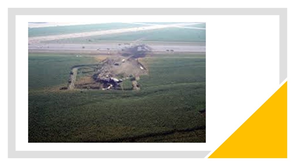
On July 19th, United Airlines Flight 232 crashed as a result of uncontrolled engine failure and loss of flight controls in Sioux City, Iowa, killing 122 of the 296 crew and passeners on-board, with 184 survivors.

The accident was considered a prime example of successful crew resource management because of how the flight was landed, the high number of survivors, and how the crew handled the emergency.

The Alice Springs Hot Air Balloon crash killed 13 people on August 13th.

Two hot air balloons collided near Alice Springs in Australia’s Northern Territory, causing the lower one of them to crash to the ground.

The Northern Territory Supreme Court sentenced Michael Sanby, the pilot of the upper balloon to 2-years in jail with an 3-month non-parole period, after being found guilty of committing a dangerous act, but not guilty on 13 charges of manslaughter.

Sanby’s conviction was subsequently overturned on appeal.

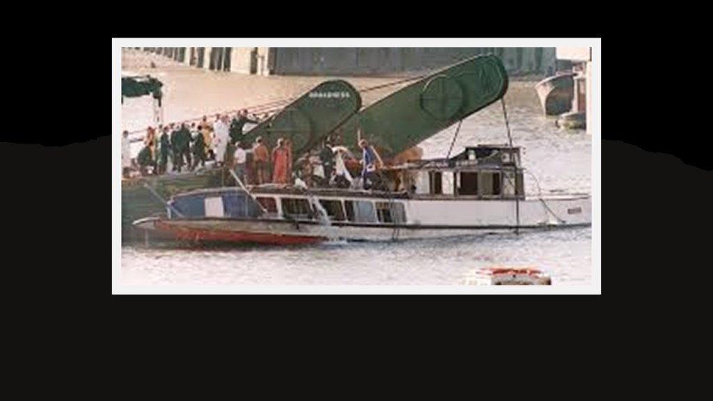
On August 20th, fifty-one people died after a pleasure boat was hit twice by the dredger Bowbelle in the River Thames between the Cannon Street Railway Bridge and the Southwark Bridge in London in what was known as the Marchioness Disaster, after the name of the pleasure boat.

The investigation after the disaster considered it likely that the dredger struck the pleasure boat from the rear, causing the pleasure boat to turn to the left, where it was hit again, pushed along and turned over, going under the Bowbelle’s bow.

It took under a minute for the Marchioness to completely sink, and 24 bodies were found within the ship when it was raised.

The captain of the Bowbelle was charged with failing to have an effective lookout on the vessel, but two cases against him ended with a hung jury.

Colombia’s cocaine traffickers declared war against the government on August 24th, and unleashed a wave of bombings, arson and terror, in retaliation for official efforts to extradite drug kingpins to the United States for trial. A commando group financed by the cocaine cartels blew up the headquarters of two political parties; torched the homes of two prominent politicians and issued a statement threatening government officials, business leaders, and judges.

On September 14th, the Standard Gravure shooting took place in Louisville, Kentucky.

Shooter Joseph Wesbecker, a pressman, entered his former work place at the printing company Standard Gravure, killing 8 and injuring 12 before killing himself, resulting in the deadliest mass shooting in Kentucky’s history.

Wesbecker had a long history of psychiatric illness and was treated for it in hospitals at least three times between 1978 and 1987.

The murders resulted in a high-profile lawsuit against Eli Lilly and Company, manufacturers of the antidepressant drug Prozac, which Wesbecker had begun taking during the month prior to his shooting rampage.

The case was resolved by settlement rather than jury verdict.

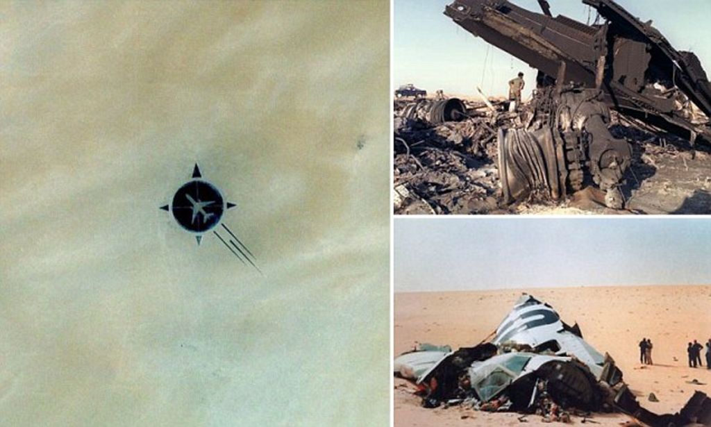
The French airline UTA flight 772 was a scheduled passenger flight that exploded and crashed near Bilma in Niger after a bomb exploded in flight, killing all 171 on-board, and debris from the aircraft’s explosion was spread all over hundreds of square miles of desert.

The deadliest aviation incident to occur in Niger, the Islamic Jihad Organization claimed responsibility, and 6 Libyan terrorists were tried in absentia since Muammar Qaddafi did not allow them to be extradited.

The motive for the bombing was said to be revenge against France for supporting Chad against the expansionist policies of Libya toward Chad.

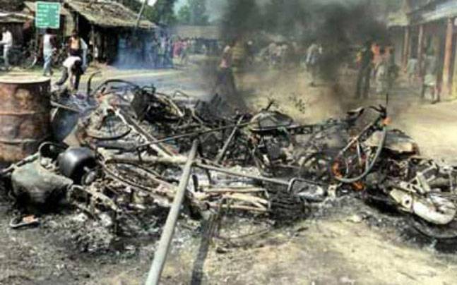
The Bhagalpur Violence, a major incidence of religious violence between Hindus and Muslims, started in the Bhagalpur District of Bihar State in India on October 24th, killing an estimated 1,000 people, and displacing an estimated 50,000.

The killing, arson, and looting lasted for another two months.

Prior to the outbreak of the riots, two rumors about the killing of Hindu students started circulating: one rumor stated that nearly 200 Hindu university students had been killed by the Muslims, while another rumor stated that 31 Hindu boys had been murdered with their bodies dumped in a well at the Sanskrit College.

Apart from these, the political and criminal rivalries in the area also played a role in inciting the riots.

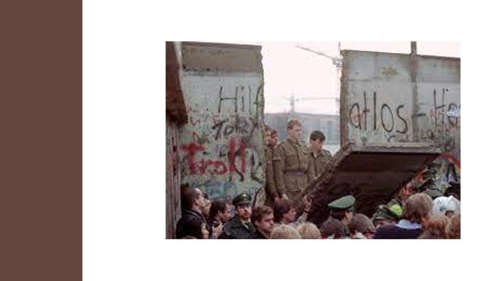
East Germany opened check-points in the Berlin Wall on November 9th, allowing its citizens to travel freely to West Germany for the first time in decades.

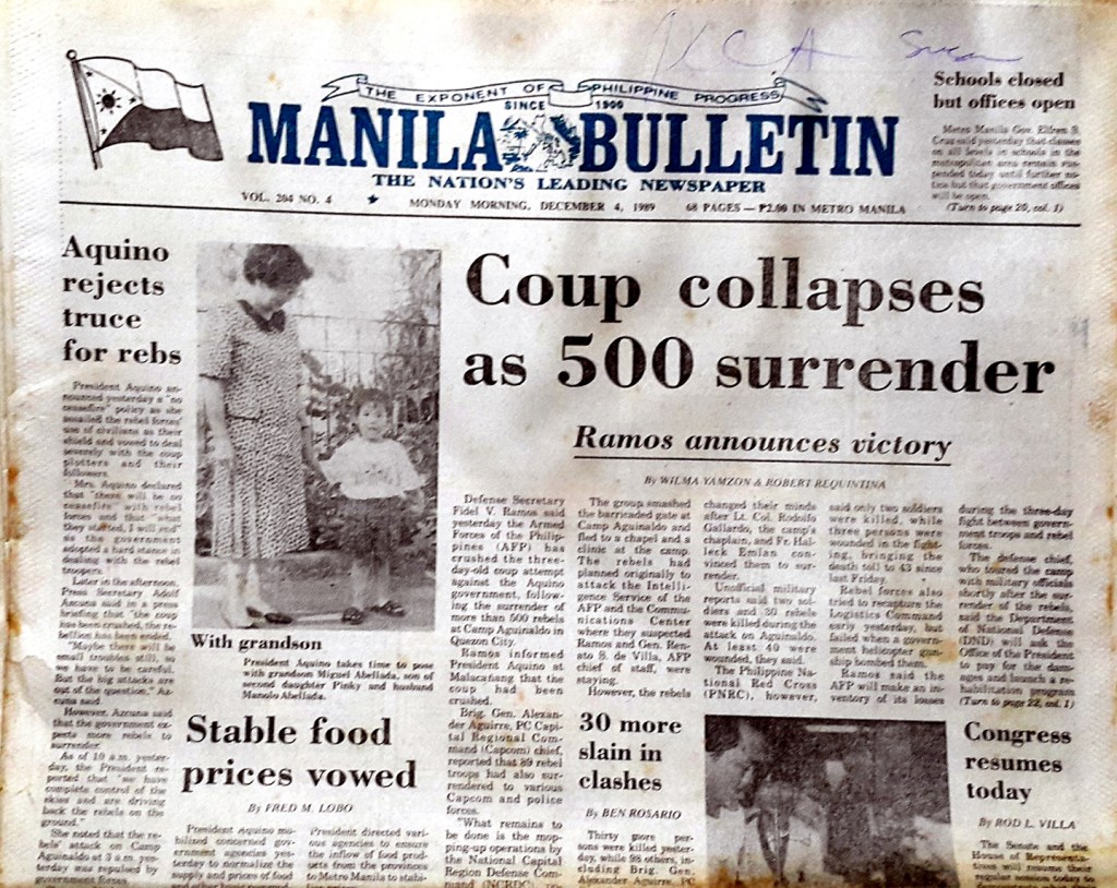
On December 1st, a military coup was attempted in the Philippines against the government of Philippine President Corazon Aquino that was crushed by U. S. government intervention, ending on December 12th.

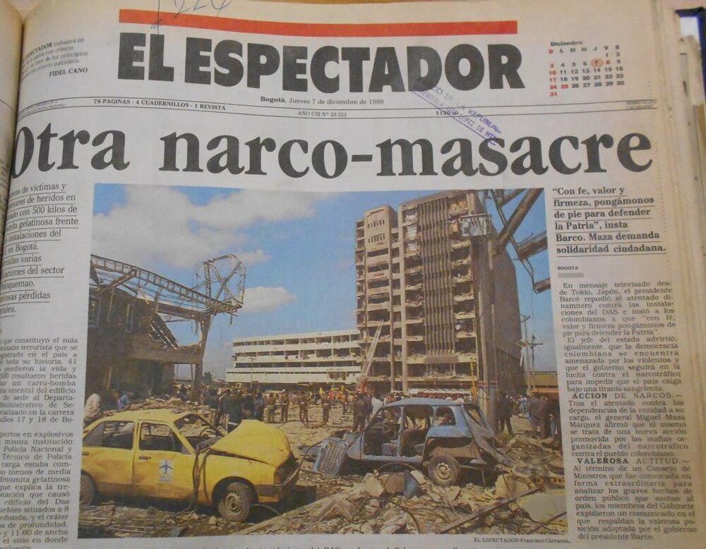
The DAS, or Administrative Department of Security, building was truck-bombed in Bogota Colombia, on December 6th, killing 57 and injuring 2,248, in an attempt to assassinate General Miguel Maya Marquez, Director of the DAS, who escaped unharmed.

The Medellin Drug Cartel led by Pablo Escobar was believed to be behind the bombing.

The DAS bombing was the last in the long series of attacks that targeted Colombian politicians, officials, and journalists in 1989.

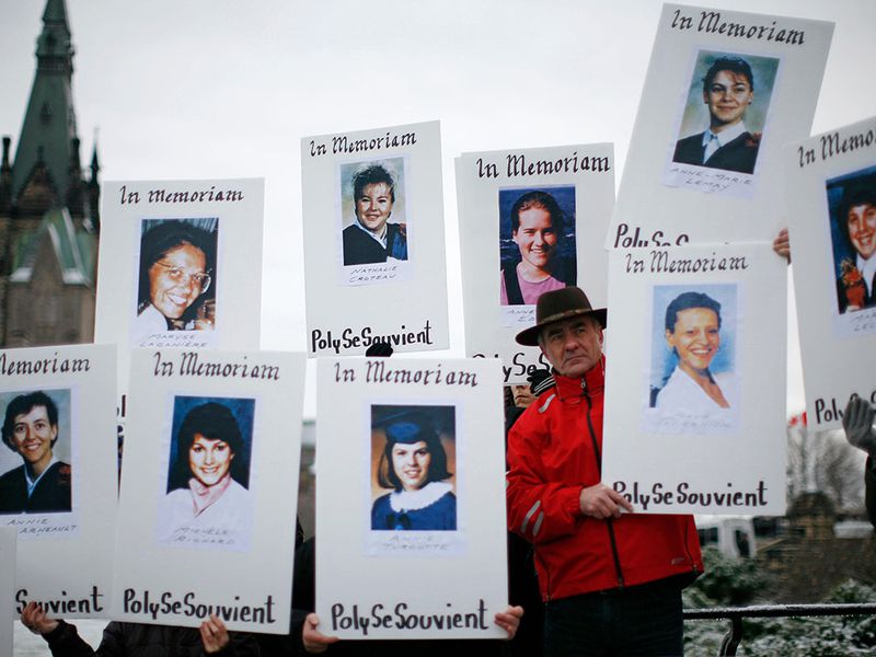
The Montreal Massacre took place on the same day as the DAS building bombing, where a gunman killed fourteen women at the Polytechnical School in Montreal, and 10 other women and 4 men were injured.

The gunman, Marc Lepine, targeted women, stating that he was “fighting Feminism.” After 20-minutes of a shooting spree through the building, he killed himself.

It was the deadliest mass shooting in modern Canadian history. The incident led to more stringent gun control laws in Canada.

The U. S. Invasion of Panama, code-named Operation Just Cause, was launched on December 20th in an attempt to overthrow Panamanian President Manuel Noriega, and lasted until late January of 1990.

As a result of the operation, Noriega surrendered the to the U. S. Military, and President-elect Guillermo Endara was sworn into office.

Here is what I am seeing thus far in “Seeing History with New Eyes since 1945,” with an eye towards uncovering the patterns that give us insight into the world we live in today.

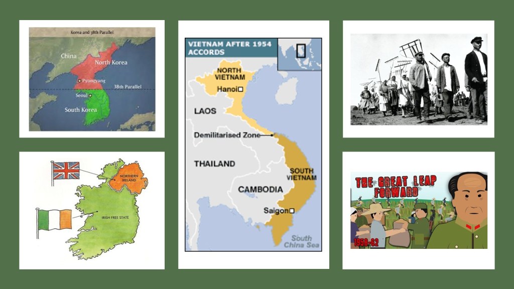
Between 1945 and 1960, I uncovered things like how events and people have been manipulated for particular outcomes benefiting the world powers at the expense of other countries and their people, and at the same time, deceiving us about what was really going on to gain our consent, like with the examples of partitioning one country into two, setting up two different political systems, and then instigating them to fight each other, in the case of Korea and Viet Nam, and the inherent brutality against Humanity of communism, with Russia and China forcing citizens onto collectivized farms and subsequent famine resulting in the deaths of millions in both countries…

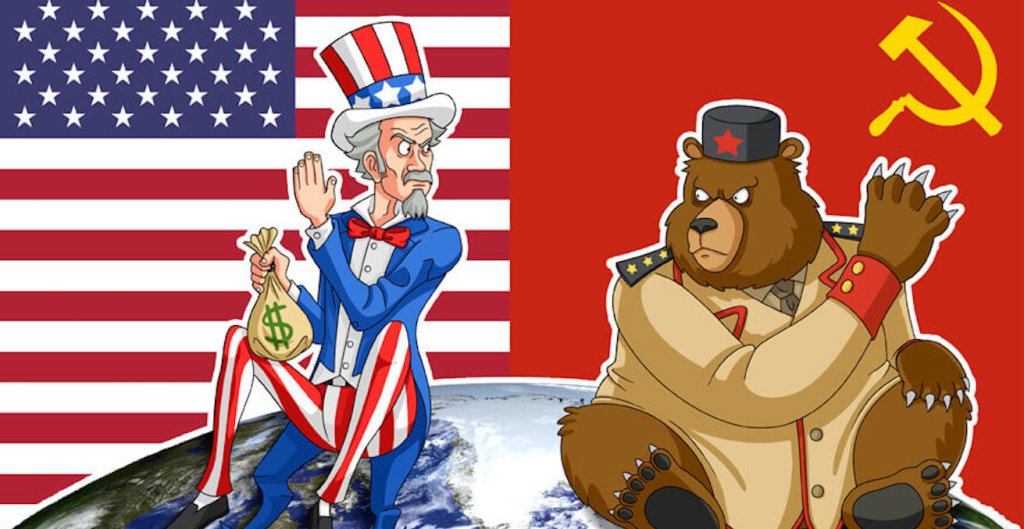
… and the beginning of the Cold War from around the formation of the Truman Doctrine in 1947, an American foreign policy which had the stated purpose of containing Soviet geopolitical expansion, until the dissolution of the Soviet Union in 1991, it was called “cold” because there was no direct fighting between the United States and the Soviet Union, but engaged instead in proxy wars by supporting different sides of major regional conflicts.

This translated to the “Capitalist” United States, and the “Communist” Soviet Union funding and providing all manner of support to the opposing sides of all of these proxy wars that happened, making all of the death & destruction possible in the first place.

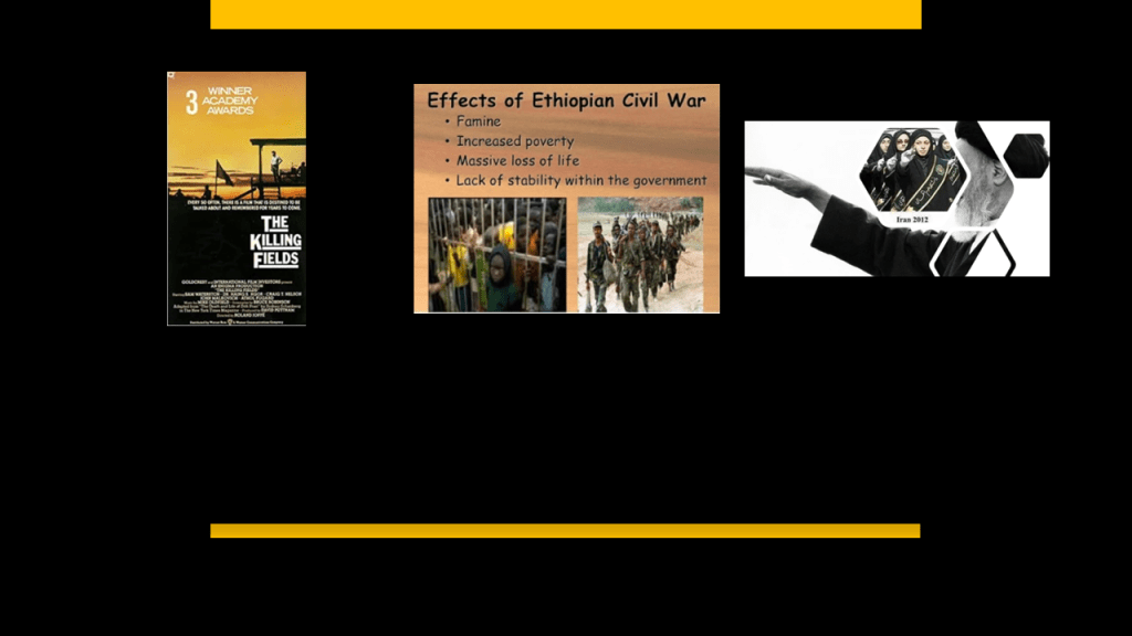
Between 1961 and 1980, Communists took down hereditary rulers in Cambodia and Ethiopia, as well as the Islamic Revolution taking down the hereditary Shah of Iran in 1979, to replace him with the Islamic Republic of Iran…

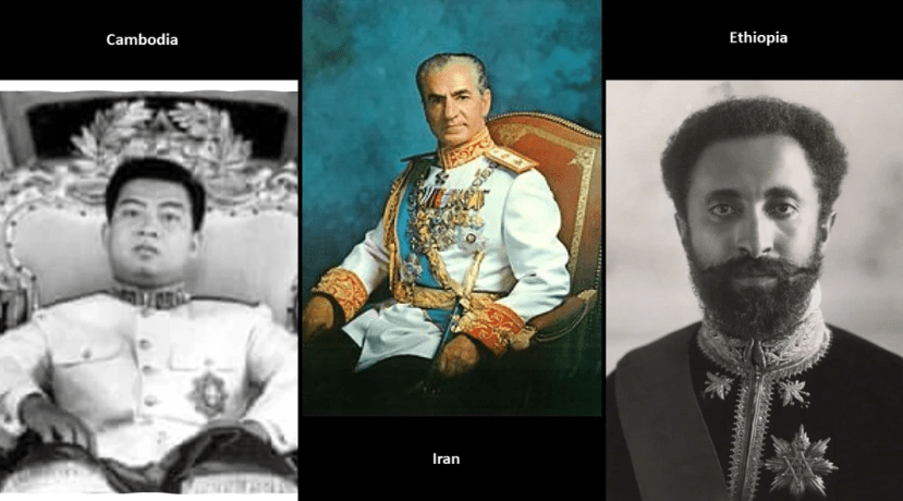
…leading to massive suffering, death, and repression in these three countries.

Every bit of all of this information signifies to me that who or whatever is behind all of this does not value any human life, and instead has sought to violently destroy it.

I was born in July of 1963, and grew up in suburban Maryland outside of Washington, D. C., several months before the assassination of John F. Kennedy.

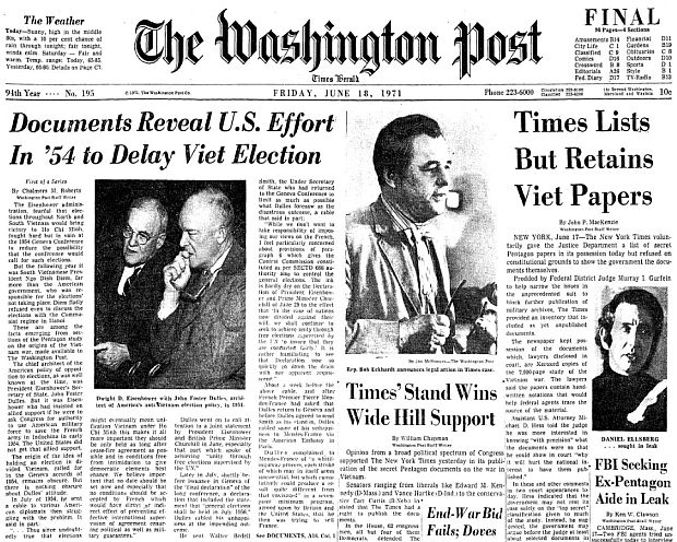
My vivid memories of events from the late-1960s & early 1970s include: making sit-upons when I was a Brownie at the ages of 7 and 8 stuffed with the Washington Post or Star containing articles about the Viet Nam War…

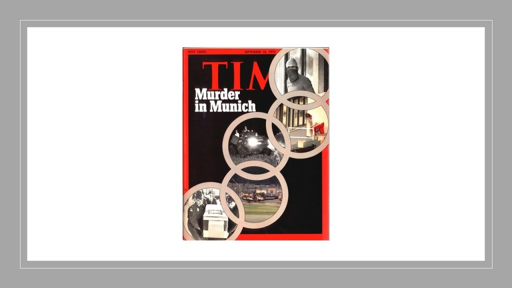
… the 1972 Munich Olympics and the attack in which 8 terrorists took nine members of the Israeli Olympic team hostage…

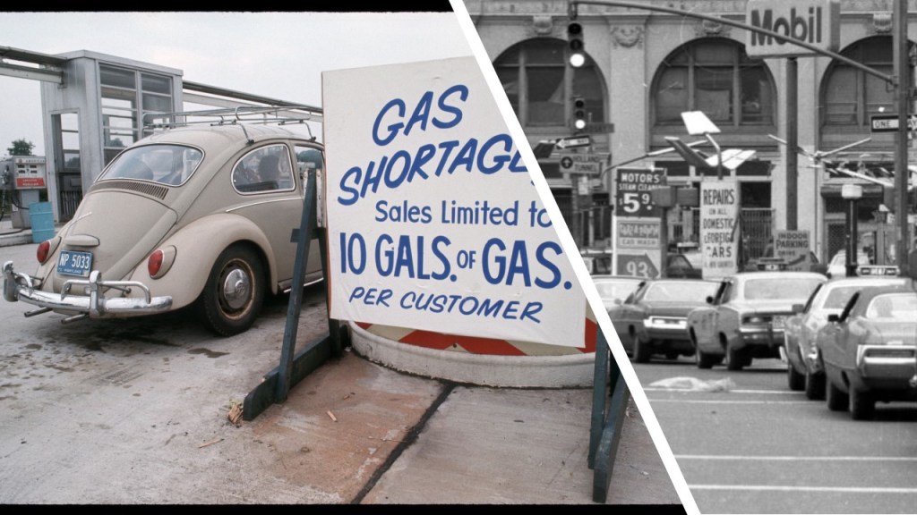
…the gas crisis that started in October of 1973 as a result of an OPEC oil embargo…

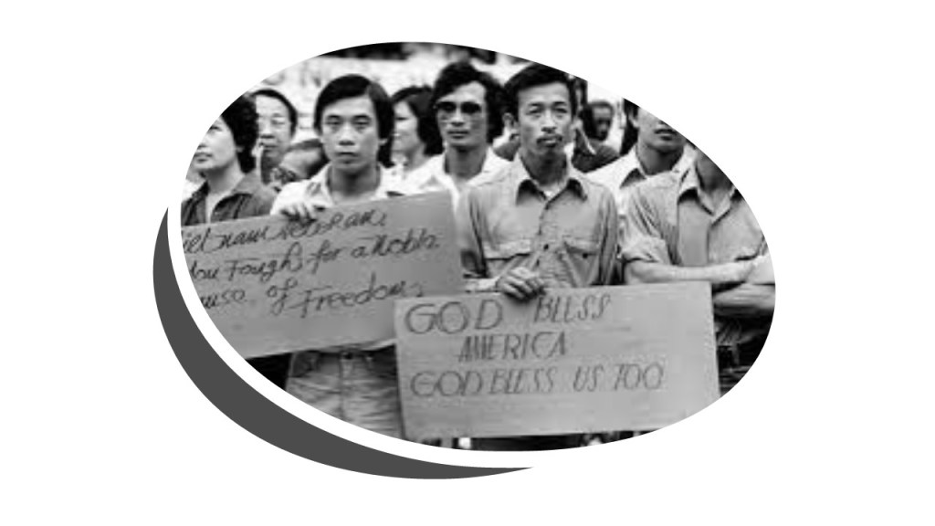
…the Vietnamese Refugee crisis, because a lot of them came to the Washington, D. C. area and lived with people I knew, so I got to know some of them…

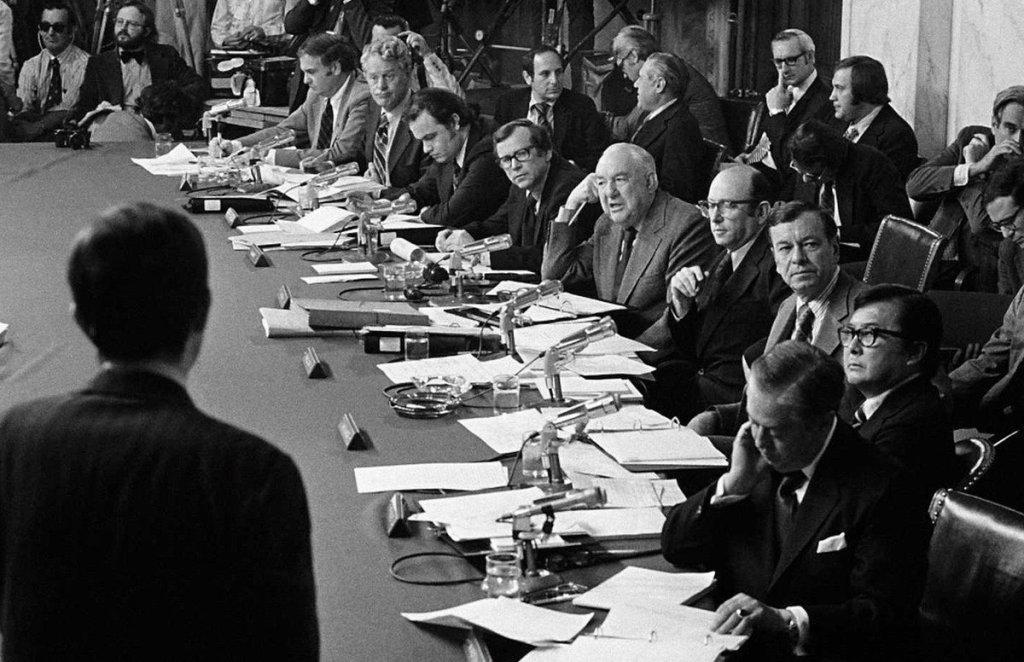
…and the Watergate hearings, which opened in May of 1973, and dominated the television programming for the next two-weeks, which was really annoying for a 10-year-old looking for something else to watch instead.

And then fast forward my life to doing this research now, and really realizing that ALL HELL BROKE LOOSE ALL OVER THE EARTH STARTING IN 1981 in a way that I did not back then, the year I graduated in high school, and the decade that began my adulthood.

Multiple Assassination attempts and assassinations; AIDS; explosions in mines; frequent plane crashes and planes blown out of the air by bombs; many massacres and atrocities against innocent civilian populations; regular people being blown up in discos and restaurants; and traumatically dying at theaters and sporting events; terrorist hijackings and suicide bombings; a multitude sinking ships and trainwrecks; single-shooter mass shooting events; and on and on and on. And that is just the 1980s so far.

Certainly, some of the incidents attributed to accident could have actually been accidents, but back then, we didn’t even think about the possibilty they could have been intentionally caused for maximum psychological effect. Our collective human consciousness has been continuously seeded from 1981 on with the notion we could meet a violent, horrible death, randomly, at any given moment, by forces beyond our control, and genocide was committed on large numbers of people in populations where there was armed conflict around the world, and that somehow all of this is normal. Over the years, our collectiveconsciousess has been raised about false flags, defined operations committed with the intent of disguising the actual source of responsibility and pinning blame on a second party.

It is also interesting from the beginning of the 1980s forward was when the personal computer and internet came into being in our lives, ultimately allowing us to instantneously connect with each other all over the world and by-pass Mainstream Media for news and information. Definitely a very important development for our mass awakening and a way out of tyranny and dystopian nightmare that was planned for us.

All of this leads me to ask this question:

Has the Earth’s population been experiencing a very calculated and undeclared Psychological War based on terror and trauma against all of Humanity for the last 40-years to bring us to what is going on against Humanity in the world in which we live in today?

All Over the Place Via Your Suggestions – Part 3 Washington State & South Wales

This is the third part of a new on-going series called “All Over the Place Via Your Suggestions” where I will continue to research your suggestions, and follow the many clues you all provide that helps to uncover our hidden history.

In part three, I was guided by looking into the suggestions and information from viewers about Port Townsend in northwest Washington; Yakima in Central Washington; and Pembroke in South Wales.

What is interesting about doing this work following up on viewer suggestions is that more often than not, unplanned themes and correlations emerge that are unique to each part, and this one was no exception. I don’t start out looking for a particular theme. I start out by selecting places people have suggested, and then I start looking to see what is there. What I found in this case are intriguing correlations and similarities between what is found in Washington State and what is found in South Wales, and I gave examples of a few other places with similar correlations from past research I have done.

My starting place for this particular journey of going “All Over the Place Via Your Suggestions” is Port Townsend, Washington.

EM sent me several pictures of buildings in Port Townsend, a port city on Quimper Peninsula at the northeast tip of Washington State’s Olympic Peninsula.

Port Townsend first became a settlement on April 24th of 1851, the year it was first incorporated.

Port Townsend is located next to the entrance of Puget Sound, and called the “City of Dreams” because of early speculation that it would become the west coast’s largest harbor, and is known by its other nickname, the “Key City,” today.

We are told that by the late 19th-century, the town was very active in getting ready for its future expected growth, and that many ornate, Victorian architecture was built here during this time.

Though railroad extensions were planned to the port, the Panic of 1893, an economic depression lasting until 1897, caused the funding to dry up and the railroad-lines ended on the other side of Puget sound, and for this reason, Port Townsend never achieved its expected growth, and instead immediately started to decline.

Puget Sound is described as a complex estuary system of connected marine waterways and basins.

An estuary is defined as a partially-enclosed coastal body of brackish water with one or more rivers or streams flowing into it, with brackish meaning a combination of salt-water and fresh-water.

EM sent me a picture of the Jefferson County Courthouse in Port Townsend.

It was said to have been built in 1892 in the Romanesque-Revival style, and designed by architect W. A. Ritchie.

W. A. Ritchie was said to have won numerous competitions for county courthouses and other public buildings in the early 1890s, and was the first architect to achieve statewide reputation in Washington.

Other buildings attributed to him, besides the Jefferson County Courthouse, include:

The Old Capitol Building in Olympia, Washington, said to have been built between 1890 and 1892…

…and the Spokane County Courthouse in Spokane, Washington, said to have been built in the French Revival and Chateauesque architectural styles in 1895.

She sent me this photo of the historic Hastings Building in Port Townsend, said to have been built starting in 1889 and completed in 1890, and designed by Elmer H. Fisher in the Romanesque architectural style of the Victorian-era.

It was considered to be the city’s most elegant building, and has always been utilized as commercial and office space.

Elmer H. Fisher was considered best-known for his architectural work in rebuilding Seattle after the 1889 Great Fire of Seattle, though interesting to note that he began and ended his career as a carpenter, while practicing as an architect in Washington between 1886 and 1891.

Besides the Hastings House in Port Townsend, he was credited with the design of the Romanesque-style Pioneer Building in Seattle, the construction of which was said to have started in 1889 and was completed by 1892.

EM also sent me a photo of the James and Fisher Building in Port Townsend.

The architectural firm of Fisher and Clark (Elmer H. Fisher and George Clark) were credited with its design, and that it was built in 1889, and owned by Francis W. James and Lucinda Hastings.

Like the Hastings Building, the James and Hastings building has also operated as commercial and office space throughout its history.

EM mentioned that there is also a “Rothschild House” in Port Townsend.

The Rothschild House was said to ahve been built by David Charles Henry Rothschild as a family home in 1868, and operates as a museum today.

He had immigrated from Bavaria in Germany to the United States in the mid-1840s.

Shortly after settling in Port Townsend in 1858, David Rothschild, known as “The Baron,” he established a business there that not only operated as a mercantile store, but as well as provisioned ships and did some marine salvage work.

Just want to take a look at a couple of other places in the area before I leave Port Townsend – Fort Worden, Fort Flagler, and then Fort Casey on Whidbey Island.

Fort Worden was said to have been constructed between 1898 and 1920 and as an artillery corps base to protect Puget Sound from invasion by sea, and was active as a U. S. Army base between 1902 and 1953.

From 1957 until its closure in 1971, it was utilized by the State of Washington as a Juvenile Detention facility, after which time it was turned into state park

The address for the Fort Worden State Park is 200 Battery Way E in Port Townsend.

The Point Wilson Lighthouse is on the grounds of the Fort Worden State Park, and considered to be one of the most important navigational aids in the state, where it overlooks the entrance to Admiralty Inlet that connects the Strait of Juan de Fuce with Puget Sound.

Reportedly the second lighthouse said to have been built here, it was said to have been completed in 1914, replacing an earlier one that opened in 1879.

Fort Flagler was located in nearby Nordland, Washington, at the northern end of Marrowstone Island at the entrance of Admiralty Inlet, and the Marrowstone Point Lighthouse is located nearby.

We are told that Fort Flagler, along with Fort Worden and Fort Casey, was part of a Coast Artillery said to have been built starting in the 1890s that guarded Admiralty Inlet and the entrance to Puget Sound, the major cities of which include Seattle and Tacoma.

Fort Casey was located on Whidbey Island, the largest island in Washington State, and forms the northern border of Puget Sound.

The Admiralty Head Lighthouse is located within the Fort Casey State Park.

We are told these three forts were intended to be a “Triangle of Fire” against invasion from the sea.

So, there are a couple of points I would like to make here.

First, I typically find star forts in pairs or clusters, as seen here where they form a triangle in relationship to each other.

You see the same kind of geometric relationship between star forts on Alderney, one of the Channel Islands.

Here’s a view of Fort Houmet Herbe in the foreground in a triangular relationship with Fort Quesnard on the top left, and the ruins of Fort Les Hommeaux Florains on the top right.

One definition of the “battery” is a device that produces electricity that may have several primary or secondary cells arranged in parallel or series, as well as a battery source of energy which provides a push, or a voltage, of energy to get the current flowing in a circuit. 

Another meaning of the word battery is the heavy fire of artillery to saturate an area rather than hit a specific target, and which has come to be associated with all of these so-called forts.

A third definition of battery is an assault in which the assailant makes physical contact.

I think they are telling us what these structures actually were in the first answer – that these star forts functioned as circuitry and batteries for the purpose of producing electricity and/or some form of free energy to power the Earth’s grid system and the advanced civilization, and that this is the reason there star forts are found in pairs and clusters.

The second definition of battery points to the re-purposing of these structures as artillery locations in the new time-line in order for them to appear to have a strictly military function.

And does the third definition battery apply here?

I think it does, in the sense that a major assault has been committed against the Human Race by all that has taken place here without our knowledge and consent, and removing all of this critical information from our awareness about the True History of Humanity, and so, so much more.

Another thing I would like to bring forward is the consistent finding of light houses co-located with star forts as seen in this example of one at each of the three star forts at the entrance to Puget Sound.

I don’t think lighthouses functioned as advertised either.

While I do believe that lighthouses likely served to guide ships through maritime passages, I also think they were serving multiple purposes on the earth’s grid system.

Perhaps “lighthouses” were literally functioning as “a house for light” for the purposes of precisely distributing the energy generated by this gigantic integrated system that existed all over the Earth that was in perfect alignment with everything on Earth and in heaven.

Next, HS directed my attention to her hometown of Yakima, Washington.

One of the nicknames of Yakima is the “Heart of Central Washington,” and is a productive agricultural region known in particular for apples, wine, and the hops used for beer-making.

There were a number of places that HS directed my attention to in Yakima.

First, she said the A.E. Larson building has always stood out as very odd to her, even as a small child.


The A.E. Larson Building was said to have been built by entrepreneur Adelbert E. Larson in 1931, and designed in the Art Deco architectural style by local architect John W. Maloney.

At eleven-stories, it was and is the tallest building in Yakima.

The architect John W. Maloney was credited with the design of numerous buildings in Washington, Alaska, and California, including but not limited to the Shaw-Smyser Hall at Central Washington University in Ellensburg…

…the Old Providence Hospital in Anchorage, Alaska, that opened in 1939 and operated through the Sisters of Providence…

…and St. John’s Hospital in Santa Monica, California, which opened in 1942 and operated through the Sisters of Charity.

Then there’s A. E. Larson’s Rosedell mansion in Yakima.

Here’s what we are told about it.

It was said to have been built between 1904 and 1909 for Adelbert E. Larson and his wife Rose (hence “Rosedell”).

The Larson’s lived here until Rose’s death in 1945, and the property was willed to the city for the purpose of turning the mansion into an art gallery. The City of Yakima, however, sold the property and the money provided for its upkeep, and used the funds to create the Larson Art Gallery at the Yakima Valley Community College.

The property went through several owners of the years, and sat empty for 18-years before being purchased by new owners who converted the mansion into a Bed-and-Breakfast, which opened in 2009.

HS sent me a picture of the Capitol Theater, a performing arts venue in downtown Yakima, originally featuring Vaudeville acts. Today it is the home of the Yakima Symphony Orchestra.

It was said to have been designed in the Renaissance architectural style by Scottish architect B. Marcus Priteca, and first opened in April of 1920.

Industrialist Chester A. Congdon was an attorney and mining magnate was credited with funding the building the Yakima Valley Canal, said to have been built in 1894 for the purposes of irrigation.

The privately-owned Congdon Castle was said to have been built for him between 1914 and 1915 (which would have been during World War I).

Congdon died in 1916, the year after construction was said to have been completed.

Congdon Castle is surrounded by fruit orchards, and trolley tracks running out to the Congdon Orchards used to run along the south-side of the castle.

The Yakima Valley Trolley system started operating in 1907.

In 1911, we are told that a concrete and masonry powerhouse substation was built to provide the DC electricity needed to operate the trolleys. It is a museum today.

The trolley car system operated as a city service for all intents and purposes until it was terminated in 1947.

In 2001, the Yakima Valley Trolleys Association was formed, and began to operate a rail service for the city of Yakima, and is called the “last authentic, all-original, turn-of-the-century interurban railroad int he United States.”

The Carbonneau Castle was said to have been built in Yakima by Brenda Mulrooney Carbonneau in 1908.

Brenda Mulrooney was an enterprising Irish-born and said to be the richest woman in the Klondike, having made her first fortune as a merchant during the Klondike Gold Rush, which took place in the Yukon between 1896 and 1899, which she lost but subsequently made another fortune doing other things.

Today it is a flower and gift shop.

The Carmichael Castle is located in Union Gap, a city in the Yakima Valley.

It was said to have been built in 1902 in the Queen Anne architectural-style by Elizabeth Carmichael, the enterprising Scottish-born owner of the Yakima Creamery.

Next, Viewer M suggested that I look into Pembroke and Pembroke Dock in West Wales.

Pembroke has many historic buildings, walls, and complexes, including:

Pembroke Castle, described as a medieval stone fortress founded by the Normans in 1093, the seat of the powerful Earls of Pembroke and the birthplace of King Henry VII…

…and Monkton Priory, across the Pembroke river from the Pembroke Castle, and said to have been founded in 1098 by the Anglo-Norman magnate Arnulf de Montgomery and granted to the Benedictine Order.

So, a couple of things to point out here, first about these two locations as seen on Google Earth.

Pembroke Castle has the appearance of a star fort with rounded bastions.

There are different shapes and styles of star forts all over the Earth, like these two in Puebla, Mexico – Forts Loreto and Guadalupe situated across from each other.

So it wouldn’t surprise me to find out that Monkton Priory and its grounds are in a star fort configuration as well.

The two locations are connected by what is called the Monkton Bridge…

…and on one side of the Monkton Bridge is what is called the “Monkton Pill.”

Though located right next to each other, Pembroke and Monkton are considered two separate towns.

The narrow Lower Commons are below the Monkton Bridge, where it looks like it could have been part of the water’s course at one time.

The Pembroke River flows past Pembroke Castle to the Milford Haven Waterway at the Pennar Mouth.

The Pembroke River is said to start at Manorbier Newton and meander its way to Lamphey and flows past the Pembroke Castle in Pembroke…

…but the Pembroke River doesn’t make an obvious appearance until it enters Pembroke.

When it enters Pembroke, there are three pools, the first of which is the Mill Pond, the second is the Middle Mill Pond, and the third is the Castle Pond below the Pembroke Castle.

The Mill Pond was said to be a former tidal inlet.

The Mill was an ancient corn mill powered by the tidal flow of the inlet, built soon after the Pembroke Castle was founded and granted to the Knights Templar in 1199.

A Mill said to have been at this location since 1830 was destroyed by fire in 1956 and only the foundations remain.

The Pembroke Train Station is a short-walk from the Pembroke Castle, and was said to have first opened in 1863, with the line being extended to Pembroke Dock a year later.

The original train station building was built out of limestone.

It was demolished in the 1970s and replaced with the current shelter.

The construction of the South Wales Railway was said to have been proposed in an 1844 prospectus, and opened in stages starting in 1850.

It connected the Great Western Railway to South Wales.

Pembroke Dock is a town that is located 3-miles, or 4.8-kilometers northwest of Pembroke, and situated on the River Cleddau.

Originally called Paterchurch, it grew quickly after Royal Navy Dockyards were founded here in 1814.

It ceased being used as a dockyard by the Royal Navy in 1926, not long after World War I ended, for the given reason of lack of funding.

The Royal Air Force occupied the site from 1926 to 1930, using the former dockyards as a station for seaplanes and flying boats.

During World War II, it was used as a home for international forces for flying boats, air force squadrons and naval crews.

The “Defensible Barracks” at the Pembroke Dock was said to have been built in the 1840s to house the Royal Marines based at the Royal Navy Dockyards and to cover the landward side of the dockyard from an infantry assault.

It is described as a 20-sided stone masonry fort with a dry moat.

It was acquired by a private developer in 2019, and is currently up-for-sale in for 1.2-million Euros.

One section of it has already been converted into apartments, and it is being marketed for residential or commercial use.

One more place I would like to take a look at here is the Milford Haven Waterway.

The Milford Haven Waterway is described as a natural deepwater harbor and part of an estuary that was formerly a valley drowned at the end of the last Ice Age.

As I was looking into the Milford Haven Waterway, I found five more star forts and a lighthouse.

Let’s take a deeper look!

The Stack Rock Fort was said to have been built on a small island in the waterway between 1850 and 1852 with 3-guns, and then upgraded in 1859 with a new building to totally encase the original gun tower.

There are two other star forts near Stack Rock Fort in the Milford Haven Waterway – one on Thorne Island and the other called the Chapel Bay Fort.

Thorne Island is dominated by what is described as a coastal artillery fort built in the 1850s to defend the Milford Haven Waterway, as there was concern about the expansionist policy of the French Emperor Napoleon III and the increasing strength of the French Navy.

The Chapel Bay Fort was said to have been built between 1890 and 1891 as part of the inner line of defense of the Haven, following the plan of the “Royal Commission on the Defence of the United Kingdom,” a committee formed in 1859 at the instigation of Lord Palmerston, Queen Victoria’s Prime Minister, to enquire into the ability of the United Kingdom to defend itself against attempted invasion by a foreign power, and to advise remedial action to the British government if such a situation arose.

Before I move over to St. Ann’s Head on the west-side of the Milford Haven Waterway, where there is a lighthouse, and two forts, I would like share information with you about so-called Palmerston Forts on the Isle of Wight and the Solent, the strait between the Isle of Wight and mainland Great Britain.

There were approximately 20 of these Palmerston structures along the west and east coast of the Isle of Wight, all of which were said to have been constructions resulting from the 1859 Royal Commission on the Defense of the United Kingdom.

The four forts in The Solent in appearance look like the Stack Rock Fort in the Milford Haven Waterway, which in turn in shape to have the appearance of a spark plug.

The coastal areas of the Solent are estuaries and have status as protected lands, like the New Forest National Park on one-side of the Solent, which interestingly includes the Exbury Gardens & Steam Railway…

…and the Exbury Gardens are world-famous for the collection of Rhodedendrons and Azaleas of its Rothschild owners.

Now over to St. Ann’s Head, where we find the lighthouse bearing its name; the West Blockhouse Fort and the Dale Fort.

First, the St. Ann’s Head Lighthouse.

Trinity House was said to have first built two lighthouses here in 1714 at the entrance to the Milford Haven Waterway to guide ships around rocks hazardous to shipping.

The St. Ann’s Head Low Lighthouse was said to have been re- built in 1844 because of cliff erosion endangering the original

Trinity House, also known as the Corporation of Trinity House of Deptford Strong, established by Royal Charter in 1514, and the official authority for lighthouses in Wales, England, the Channel Islands, and Gibraltar.

It is also a maritime charity, taking care of retired seamen, training young cadets, and promoting safety

The funding for the work of lighthouse services comes from the levying of “light dues” on commercial vessels calling at British ports based on net registered tonnage.

The West Block House Fort on West Block House Point is described as a mid-19th-century coastal artillery fort that was also constructed in response to the perceived threat of invasion of the forces of French Emperor Napoleon III, who came to power in 1851.

And, we are told, intended to protect the entrance to the Milford Haven Waterway by means of interlocking fire with the fort on Thorne Island and the Dale Fort on St. Ann’s Head, also said to have been built as a coastal artillery fort in the mid-19th-century.

Today Dale Fort is a center run by the Field Studies Council, offering field work for schools and other course offerings.

I mentioned the estuary lands of the Solent, the strait separating the Isle of Wight from mainland Great Britain, and the Exbury Gardens in the New Forest National Park.

I noticed the Gower Area of Outstanding Natural Beauty (AONB) to the southeast of Pembroke and Pembroke Dock along the coastline of South Wales, and decided to go take a look at what they tell us about it.

In 1956, most of the Gower Peninsula became the first area in the United Kingdom to be designated as an “Area of Outstanding Natural Beauty,” an area that has been designated for conservation due to its significant landscape value.

In my research, I have consistently found the world “natural” to be a cover-up code word for the original civilization.

The Gower Peninsula is bounded to the North by the Loughor Estuary and Swansea Bay to the East.

Worm’s Head is located at the furthest westerly point of the Gower AONB.

Worm’s Head is described as a headland of three islands comprised of “carboniferous limestone,” meaning the collective term for the succession of limestones occurring widely throughout Great Britain and Ireland during the Dinantian Epoch of the Carboniferous period, which occurred roughly 340-million years ago.

Worm’s Head is only accessible on foot for 2 1/2-hours either side of low tide, and yes, people have gotten stuck out there.

The formation known as the “Devil’s Bridge” is located on the middle island.

It is important to note here that limestone was a popular building material in the Ancient World.

I just want to point out that limestone was a common building material in the ancient world, and used in constructions like the Pyramids of Giza…

…and the Western Wall, also known as the “Wailing Wall,” an ancient limestone wall in the old city of Jerusalem.

The Goat’s Hole Cave, one of the Paviland Caves in Gower, was excavated in 1823, and is considered one of the most famous archeological sites in Great Britain due to the discovery of the “Red Lady of Paviland,” though the skeleton has since been determined to have been of a man.

The skeletal remains were dyed in red ochre, and said to date back to 31,000 BC and recognized as the earliest ceremonial burial in Europe and the first human fossil remains found in the world.

The Gower Peninsula is home to what is called the “Parc le Breos” burial chamber, a chambered long barrow or cairn, believed to have been constructed during the Neolithic age in Britain, around 6,000 BC and discovered in 1869 by workmen digging for road stone.

What I am aware of from other such long barrows in Great Britain is that they have important astronomical and landscape alignment features, and most likely not built to be burial chambers.

The West Kennet long barrow in the Avebury Complex is a great example of what I am talking about.

I saw a presentation by Peter Knight about the West Kennet Long Barrow for the Glastonbury Megalithomania Conference in 2011, several years before I started putting all of this together in 2016. From watching it, I gained an important piece of the puzzle, well before I really understood what it meant.

In Peter Knight’s presentation, his focus was primarily on the West Kennet Long Barrow in the Avebury complex, which is a greater sacred landscape that is precise and intricate.

He talked about sight lines in his presentation, which refers to a normally unobstructed line-of-sight between an intended observer and a subject of interest.

So, for example, in this view from Windmill Hill, there is a visual connection between Windmill Hill, Silbury Hill, and the West Kennet Long Barrow seen here.

All of the sites in the complex are perfectly aligned in some manner with each other.

There are abundant solar and lunar markers in the Avebury landscape.

Here is a winter solstice sunset seen in the landscape from the entrance of the West Kennet Long Barrow…

…and it is framed in the entrance of the West Kennet Long Barrow as seen from inside the Long Barrow on the solstice, when light streams through to special stones waiting at the end of the chamber.

There are also abundant astronomical markers inside the long barrow, in the chambers within.

From inside the West Kennet Long Barrow, there are places where you can see things at certain times, like the Equinox moonrise…

…and the Pleiades.

We are told there are eight remaining standing stones known as “menhirs” in the Gower Peninsula, out of nine that were originally here.

King Arthur’s Stone was one of them.

It has a 25-ton, or 23-metric-ton, capstone, and also described as a chambered burial tomb.

The presence of the large capstone was attributed to its being a glacial erratic, a massive piece of rock carried by glacial ice, and we are told that builders of the tomb dug underneath and supported it with upright stones to create a burial chamber.

While the term “glacial erratic” is used frequently to describe such massive structures found in North America, like Tripod Rock at the Pyramid Mountain Natural Historic Area in Kinnelon, New Jersey…

…around the world these structures are known as “dolmens,” classified as a single-chambered megalithic tomb.

By the way, there are tons of what are designated as glacial erratic boulders in Washington State, including but not limited to, the following:

Back on the Gower Peninsula, we are told the Romans built a trapezoidal fort called Leucarum at the mouth of the River Loughor in the late first-century to house a regiment of Roman auxiliary troops.

Its remains are located beneath the town of Loughor, on the estuary of the River Loughor.

The Loughor Railway Station was on the South Wales Railway, which today is the West Wales Line, from Swansea to Llanelli.

Isambard Kingdom Brunel was an English civil and mechanical engineer who was credited with the building of the Great Western Railway, along with dockyards and steamships, and called “one of the 19th-century engineering giants,” and “one of the greatest figures of the industrial revolution.”

The Loughor Viaduct going across the River Loughor was said to be the last remaining timber viaduct designed by Kingdom Brunel in 1852.

The old viaduct was replaced and the new one opened in April of 2013.

A section of the old viaduct sits next to the new viaduct in order to recognize it as an important historic monument.

The last place that I would like to take a look at on the Gower Peninsula is Mumbles, a headland situated on the western edge of Swansea Bay.

The building of the Mumbles Lighthouse was said to have been completed in 1794, and we are told the Mumbles Battery, a Palmerston fort, was built around the base of the lighthouse between 1859 and 1861.

Mumbles Pier was said to have opened in 1898 at the terminus of the Swansea and Mumbles Railway.

The Swansea and Mumbles Railway was the world’s first horse-drawn public passenger train service.

It first opened in 1804 to transport iron ore from the Clyne Valley and limestone from the quarries of Mumbles, and then opened in 1807 to passenger train service.

Steam-power replaced horse-power in 1877, and was used until 1929, when it switched to electric-power until the closure of the line in 1960.

Mumbles had both historical limestone quarries and was part of the Gower lime burning industry, which operated between 1840 and 1960.

The lime-burners job was to removed quick lime from limestone heated in what were called lime kilns to be used for things like building mortars.

This lime kiln looks like a really old stone building to me!

One of the last lime kiln quarries of this industry was the Colts Hill Quarry, immediately west of Oystermouth Castle, which produced both limestone and marble, in addition to quick lime.

Marble is a form of limestone capable of taking on a high polish, like this example of a memorial made from Mumbles marble at the Margam Abbey Church across Swansea Bay from Mumbles.

The Oystermouth Castle in Mumbles was said to have been a Norman stone castle built during the 1100s, and was already said to have been in decay by 1650, when it was described as such in a survey of Gower at that time.

When I was reading an article about “Elliptical Polarization” awhile back, I encountered the diagram showing the efficiency in decibels of the axial ratio of two antenna, and the shapes formed in the graph immediately brought this common shape of windows in cathedrals on the right, compared with the chapel window at Oystermouth Castle.

Were these windows actually functioning as antennae for sound?

Oyster beds and oysters were plentiful in the waters around Mumbles, and the hey-day of the oyster-harvesting industry was from 1850 until 1873, after which time the oyster industry went into decline as a mainstay of the economy for a variety of reasons, including the coming of the railroad and the growth of Mumbles as a tourist destination.

As always, there is much more to find here, but now I am going to wrap things up with a summary of my findings.

Here are the similarities and correlations I have found between Washington State, South Wales, and a few other places that have come to mind in the process of doing the research for this.

First, we have the presence of forts that were said to have been built as coastal artillery batteries to protect the entrances to important waterways.

Starting in the mid-19th-century, we are told that three Palmerston Forts in a triangular configuration were constructed at the entrance to the Milford Haven Waterway as a coastal artillery forts designed to provide “interlocking fire” in the event of an invasion from the forces of the French Emperor Napoleon III.

Then, later in the 19th-century through the early 20th-century, three forts were said to have been built in the Admiralty Inlet at the entrance to Puget Sound as coastal artillery forts designed to create a “Triangle of Fire” in the event of an invasion from the sea.

There are lighthouses in both places.

Not surprisingly, right, as all of these are coastal areas needing lighthouses to guide ships?

But what if lighthouses served as something much greater than just as navigational aids for ships, as I suggested previously.

Lighthouses are typically found in conjunction with these forts in some capacity.

As I surmised previously in this post, what if these forts were actually functioning as batteries on the Earth’s worldwide energy grid system, and the lighthouses were precisely distributing the energy generated by this gigantic integrated system that existed all over the Earth?

Then there are castles in both places, with the turrets commonly associated with them.

In Wales, they are typically dated to having been constructed during the Norman period in 1100s in Welsh history, like the Pembroke Castle on the right.

In Washington State, there are a number of “castles” that were said to have been built as residences for entrepreneurs in the late 19th- and early 20th-centuries.

There are massive, multi-ton boulders called “Glacial Erratics” in both South Wales and Washington State, which we are told were massive pieces of rock carried by glacial ice, like the capstone of King Arthur’s Stone on the Gower Peninula of South Wales, and the Lake Lawrence Erratic in the Puget Sound region of Washington.

Then, there are estuaries.

Again, an estuary is defined as a partially-enclosed coastal body of brackish water with one or more rivers or streams flowing into it, with brackish meaning a combination of salt-water and fresh-water.

Puget Sound in Washington State is described as a complex estuary system of connected marine waterways and basins, and was said to have been carved out by the advance and retreat of massive glaciers during Ice Ages.

The ten major river drainages into the Puget Sound include: the Cedar/Lake Washington Canal; and the Green/Duwamish; Elwha; Nisqually; Nooksack; Puwallup; Skagit; Skokomish; Snohomish; and Stillaguamish.

The Milford Haven Waterway is described a natural deep harbor that was originally a valley drowned at the end of the last ice age.

The Daugleddau Estuary is part of it, and was formed the coming together of four rivers in the Pembrokeshire Coast National Park: the Western and Eastern Cleddau and the Carew and Creswell.

This is a photo of the confluence of the East Cleddau and the West Cleddau…

…and here are a few of examples of many river confluences that look very much the same.

We are told all of these rivers are natural, but I have come to believe from my research that we are looking at what were originally canal systems that were found all over the Earth.

Port Isabel on the Texas Gulf Coast is a good example of what I am talking about.

Port Isabel is located next to an estuary system called the “Laguna Madre Bay.”

The otherwise land-locked Laguna Madre Bay has two channels connecting it to the Gulf of Mexico. One is at Port Isabel, which becomes the 17-mile, or 27-kilometer, Brownsville Ship Channel…

…and the other is at Port Mansfield.

Then in Port Isabel itself, there are artificially-made channels and canals throughout the city.

There are many more examples of this all over the world, but this is the first one that came to mind.

As seen earlier, the River Loughor Estuary is at the northern end of the Gower Peninsula in South Wales.

Lastly from this post, there are estuaries found throughout the Solent, the strait that separates the Isle of Wight from mainland Great Britain…

…an area which also has numerous star forts known known as Palmerston Forts, said to have been built starting in the mid-19th-century as a result of the recommendations from the 1859 Royal Commission on the Defense of the United Kingdom.

There are many more estuaries around the world, but these coastal estuaries across continents and oceans are examples of why I think coastal landmasses sank relatively recently, and that we have been given a brand new historical narrative superimposed over the original infrastructure and civilization to tell us what happened.

Personally, I believe that the submerging of earth’s land masses was caused by a deliberately created cataclysm or cataclysms by malevolent beings who had a plan to take-over the Earth’s original civilization for their own benefit.

For another example, just a short-distance down the Pacific Coast from Washington State, in Portland, Oregon, there is a visible star fort point at the Smith & Bybee Wetlands Natural Area, which is now the location of the Bybee Lakes Hope Center for the homeless.

This urban wetlands area in Portland is located right next to the BNSF Ford Railyard. I am finding that it is not uncommon to find the presence of historical railyards and rail-lines co-located with estuaries and wetlands and forts, like what we are told was the historic Leucarum fort that is now underneath the city of Loughor on the Loughor Estuary in South Wales, with Loughor Viaduct railroad bridge crossing beside it to this day as mentioned previously.

So, what does it all mean?

Is it evidence for one original worldwide advanced civilization that was completely integrated in all ways that we know nothing about, with a false historical narrative to cover it up?

Or evidence for colonization and importation of everything from one place to another as we have always been taught to believe?

The definition of Statistical Significance is a determination that a relationship between two or more variables is caused by something other than chance.

I have presented evidence of more than two variables that would be the minimum requirement of correlations between Washington State, South Wales, and a couple of other places, to be considered statistically significant.

Yet our historical narrative leads us to believe that all of the Earth’s infrastructure came into existence as a result of random factors, like some guy in the past bought the land upon which _________________ eventually became a large city.

The definition of random includes, among others, “lacking a definite plan, purpose, or pattern.’

Besides what I have presented here, I have found many examples in past research of the flimsy nature of the randomness explanation vs. the plentiful evidence for the planned nature of an original worldwide civilization.

I am going to end this post here, and will continue to investigate your suggestions in the on-going series “All Over the Place via Your Suggestions.”