In the first-part of this series called “Circle Alignments on the Earth Amsterdam Island” that I am updating from a series I originally did between November of 2018 and January of 2019,” I tracked this circle alignment from Amsterdam Island, one of the French Subantarctic Islands in the South Indian Ocean to Berbera in Somaliland, an historic city that has served as a major commercial center and port since antiquity, and has a glorious past in terms of importance to the region but which is looking quite rough these days!
In the second-part of this series, I picked up the alignment in the Gulf of Aden on the way into Yemen from Berbera, and explored this region of the Earth around the Gulf of Aden that is prominent in human and biblical history, before heading along the alignment through Yemen, and through the Empty Quarter of the southern-third of the Arabian Peninsula, the world’s largest desert, through the United Arab Emirates and ended in Dubai, one of the world’s “Global” cities.
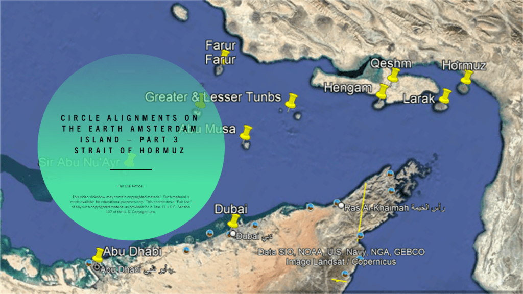
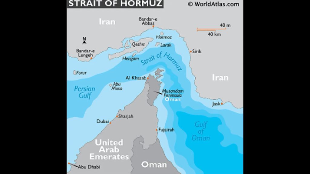
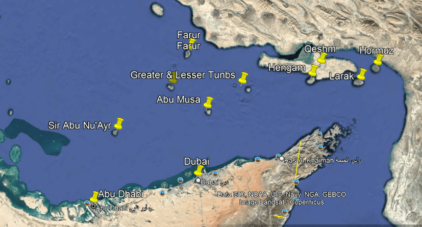
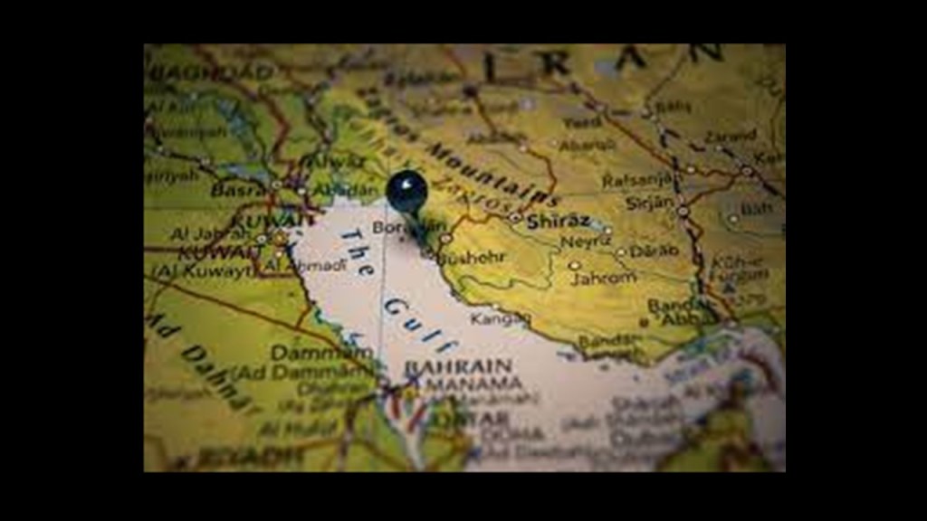
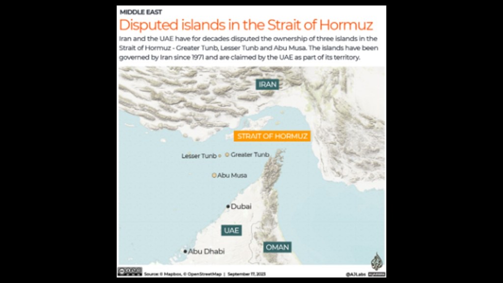
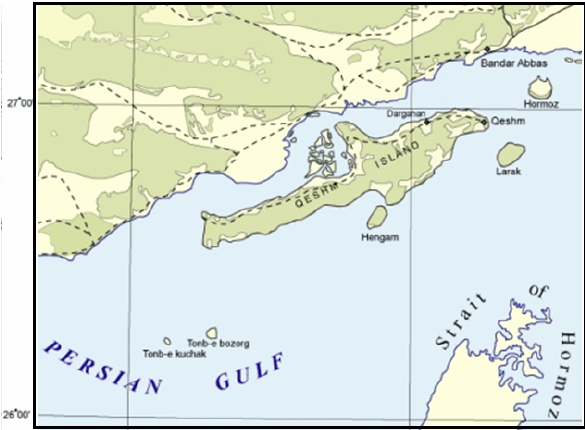
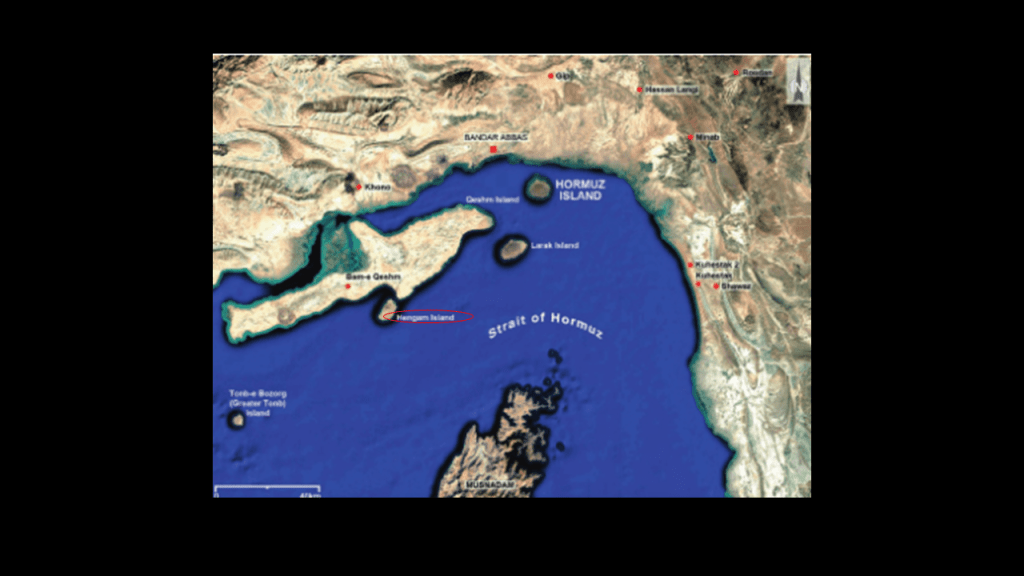
In this third-part of the series, I am picking up the alignment where it leaves the United Arab Emirates and crosses over the Strait of Hormuz and its islands to southern Iran between the Persian Gulf and the Gulf of Oman.
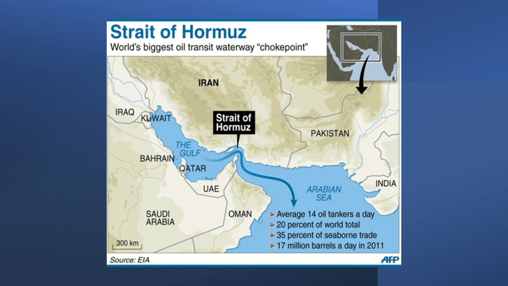
The Strait of Hormuz is the only sea passage from the Persian Gulf to the open Ocean.
The Musandam Peninsula is on the the south coast of the Strait of Hormuz, and Iran is on the north coast of it.
Additionally, there are numerous islands in the waters surrounding it that I am going to be looking at in this post.
In my journey of coming to awareness regarding this information, I have found that islands on the Earth’s gridlines are extremely interesting.
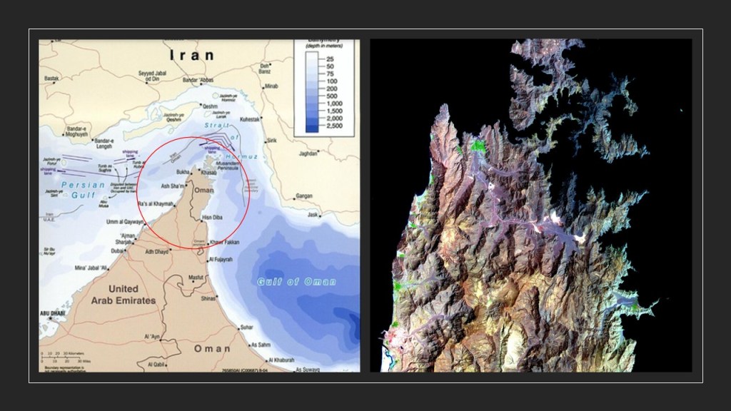
The governance of Musandam Peninsula is shared by the countries United Arab Emirates and Oman.
The United Arab Emirates govern Ras al Khaimah and parts of Dibba, and the Musandam Governate is administered by Oman.
Today, the city of Ras al Khaimah is positioning itself as a haven for wealthy individuals.
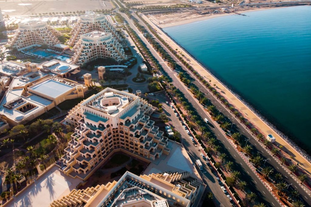
The location of Ras al Khaimah is said to have been the site of continuous human habitation for 7,000 years, and that it is one of the few places in the country and world that can say this.
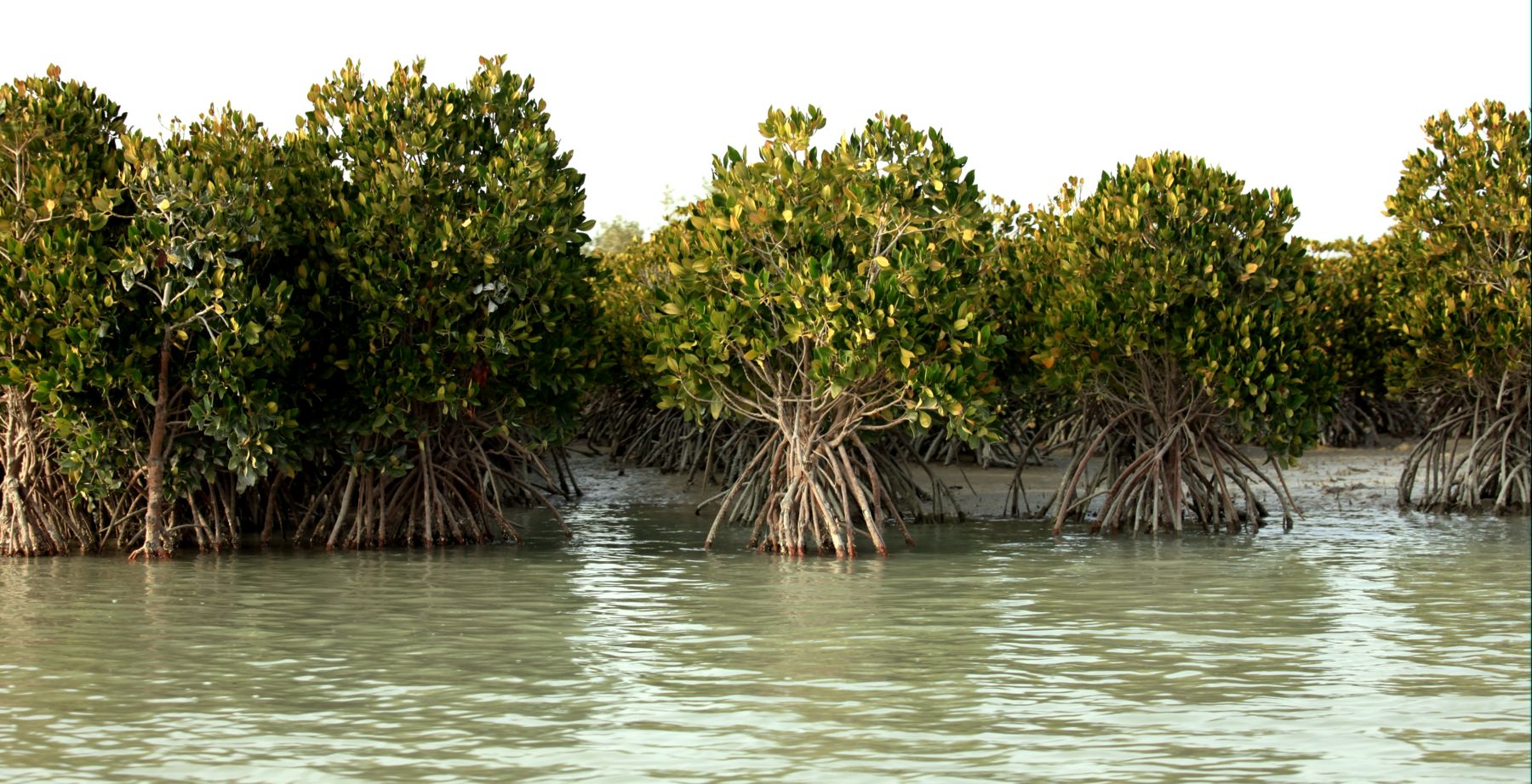
There are thriving mangrove swamps lining the coast of Ras al Khaimah, as well as inside the city.
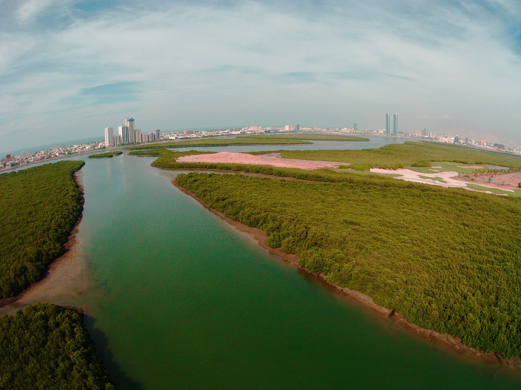
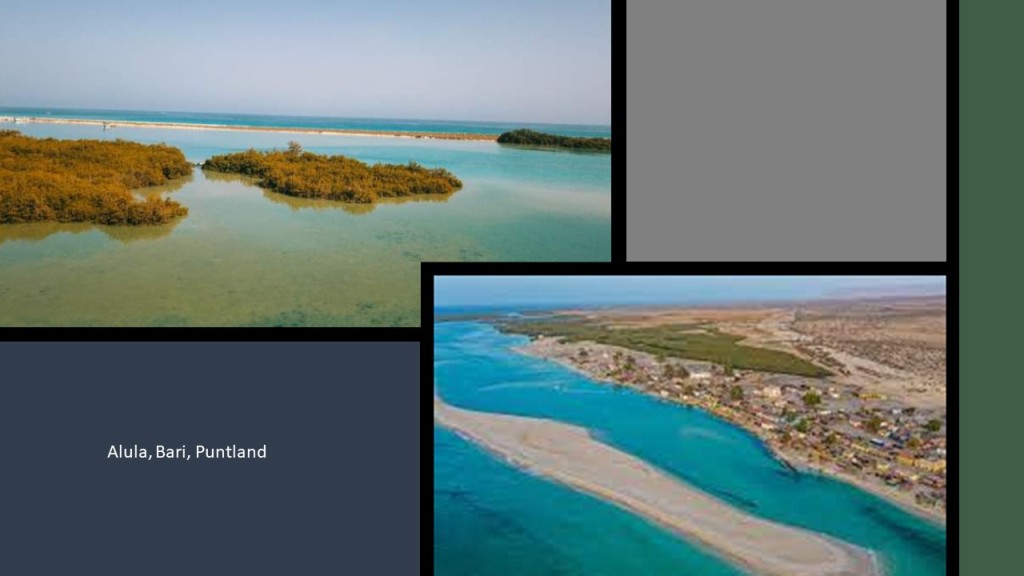
In the last part of this series, we saw mangrove swamps on the coast near Alula, the capital of the Bari Region of Somalia’s Puntland.
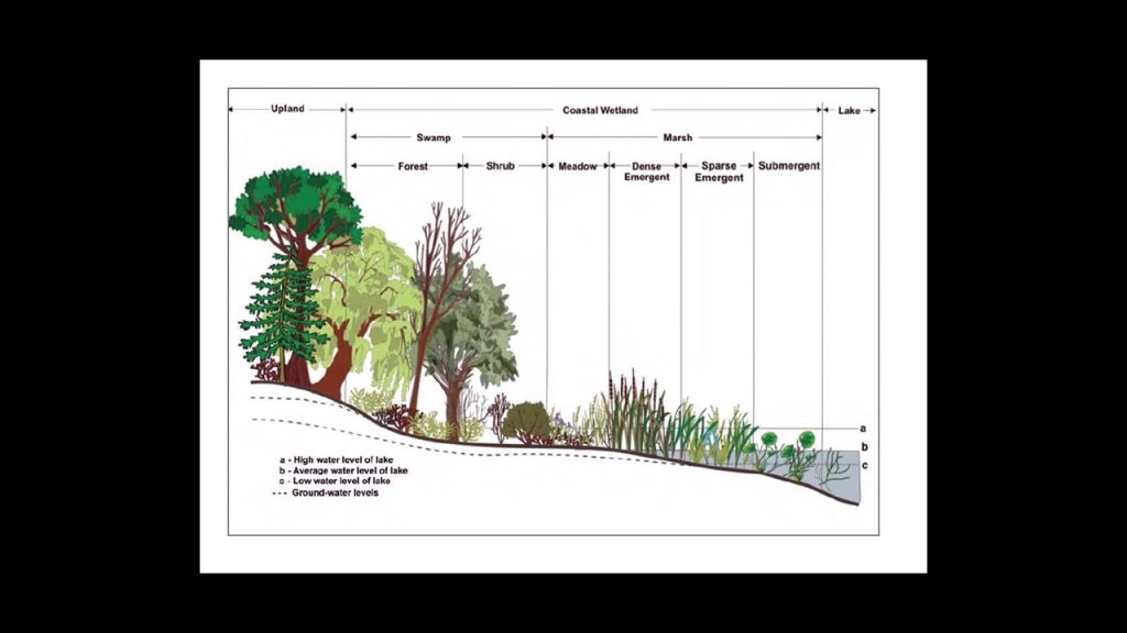
Mangroves are a type of tree that grows in brackish water.
Mangrove swamps are coastal wetlands characterized by these salt loving trees and shrubs that are typically found in estuaries, where salt water meets freshwater.
So Estuaries have water that is salty, dirty & unpleasant, and there are one or more rivers flowing into it, and a connection to the open sea.
I have been speculating for awhile now from my research that the Earth’s estuaries are actually ruined and sunken land that once had the infrastructure of civilization in it.

Sites of historical and archeological interest here include the Shimal Fort, also known as Sheba’s Palace, associated with the town wall of the port of Julfar, and was once the seat of the Ruler of Julfar, and associated with the indigenous Shihuh people.
Another archeological site of interest in the Ras al Khaimah area is the Tell of Kush, situated on an important trade route.
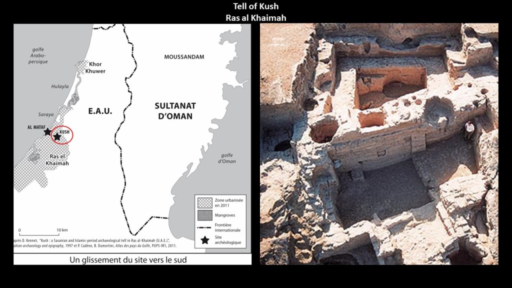
We saw the Kingdom of Kush back across the Arabian Peninsula and Red Sea from here in East Africa in the last part of this series, an ancient kingdom of Nubia historically in what is now southern Egypt and northern Sudan.
I am going to leave this here for contemplation.
It won’t be the last time was see a “Kush” on this alignment as we go through this series.
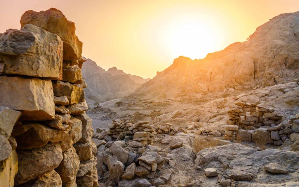
Musandam is the home of an ancient people, the Shihuh, that are indigenous to the jagged peninsula, who inhabit the Hajar Mountain Range in the northern part of it.
The Shihuh are divided into two main sections: the Bani Hadiyah and the Bani Shatair.
Long influential in this region, they have fiercely maintained their identity and independence.
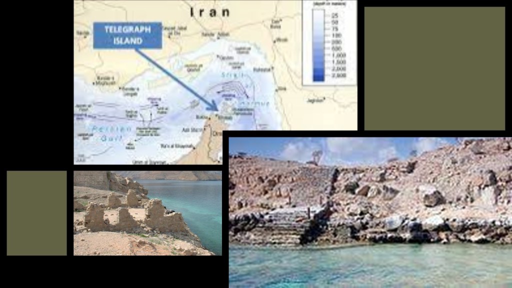
Telegraph Island is located in what was named the Elphinstone Inlet for the East India Company’s then-Governor of Bombay, Mountstuart Elphinstone, and was the location of a telegraph repeater station built by the British there in 1864, only to be abandoned in the mid-1870s , and remains deserted to this day.
We are told that the slang term in English “going ’round the bend,” meaning a feeling of exasperation, came from the telegraph workers who were stationed there, with its heat, rocks, and isolated location.
The Strait of Hormuz is the world’s biggest oil transit waterway “chokepoint.”
At least 20% of the world’s petroleum passes through here, and one-third of the world’s liquefied natural gas, and is a highly important strategic location for international trade.
Not surprisingly, this is a tense area, to say the least!
There a couple of things to mention about this.
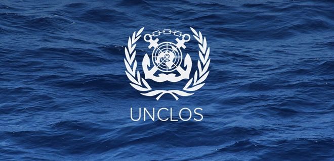
One is that the ships that pass through the territorial waters of Oman and Iran through the Strait under the “Transit Passage” provisions of the “United Nations Convention on the Law of the Sea,” first adopted in 1982, which established a legal framework for all marine and maritime activities.
While not ratified by all countries, it is accepted by most as customary navigation rules.
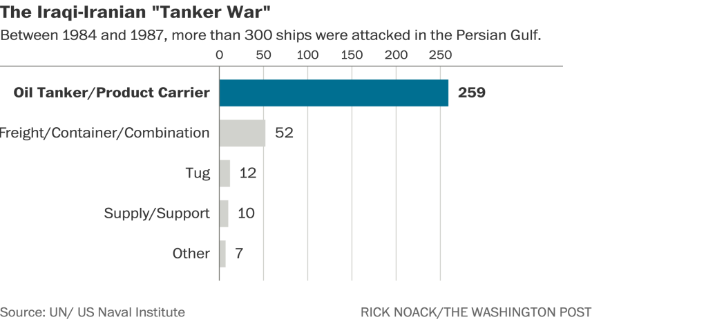
The Strait of Hormuz has been site of many military conflicts and attacks over the years, including but not limited to the 1984 Tanker War that took place during the Iran-Iraq War when Iraq attacked the oil terminals and tankers on Iran’s Kharg Island in the Persian Gulf, said to have been done to provoke Iran into retaliating with extreme measures, and lasted for several years.
Next, I will share with you what I found out about the Islands of the Strait of Hormuz.
These islands are windows to a hidden history.
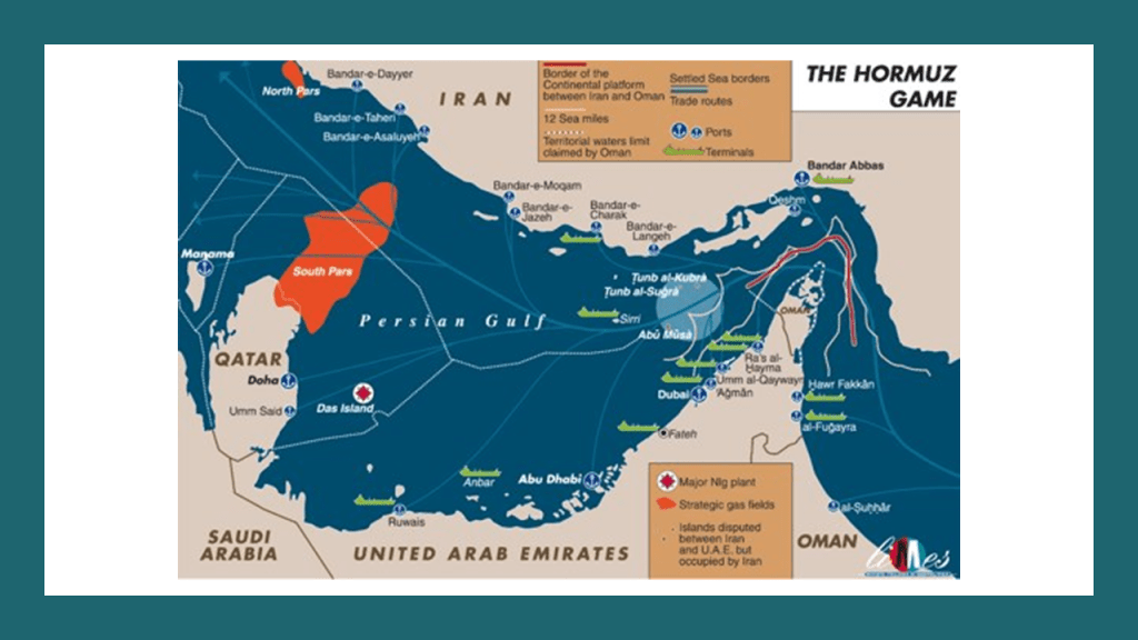
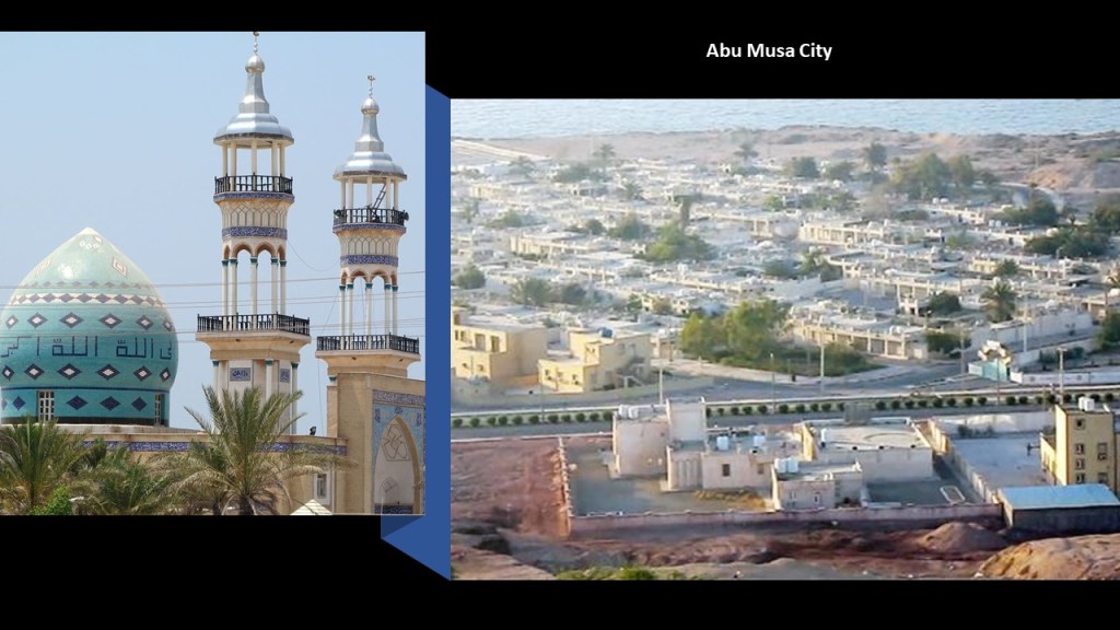
First, Abu Musa.
I mentioned Abu Musa in my recent post called “What is it Exactly about the World’s Disputed Islands,” in which I looked at seemingly insignificant islands and island groups that are the subjects of territorial disputes between countries, that I keep coming across in tracking different long-distance alignments of cities and places and the Earth, and speculated on the possibility they were once giant-tree locations.
The island of Abu Musa is contested between the United Arab Emirates and Iran.
It has been administered by Iran as part of the Hormozgan Province since 1971.
It is the furthest Island from the Iranian coast, and is strategically important as it sits near the entrance to the Strait of Hormuz, and because of sea-depth, ships and oil tankers must pass between Abu Musa and the Greater and Lesser Tunb islands, also administered by Iran, on their way through.
The size of Abu Musa is 4.9-square-miles, or 12.8-kilometers-squared.
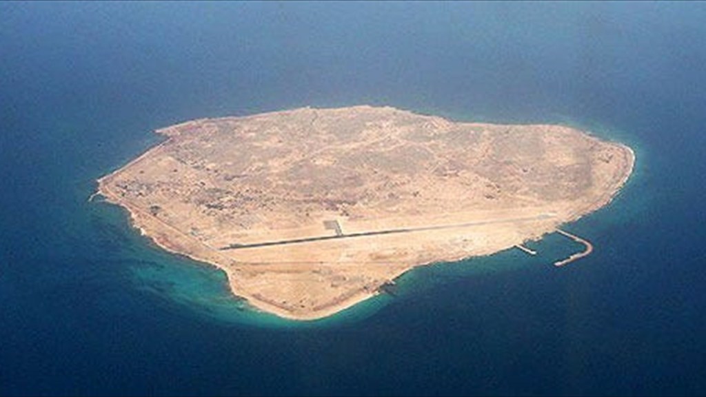
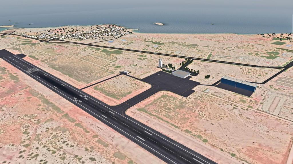
Abu Musa City is the largest settlement on the island, with a population of somewhere around 2,000 people.
This tiny island even has its own regional airport.
Between 1908 and 1968, the British controlled the Abu Musa, along with other islands in the Persian Gulf.
There are iron oxide deposits on Abu Musa.
Before I go into the iron oxide deposits found on Abu Musa specifically, this is a good place for me to insert background about the British East India Company’s “Persian Gulf Residency.”
This is what we are told.
The “Persian Gulf Residency” was a sub-division of the British Empire from 1822 to 1971, during which time the United Kingdom maintained varying degrees of economic and political control over several states in the Persian Gulf, including the United Arab Emirates, and at different times, over the southern portions of Persia (Iran), Bahrain, Kuwait, Oman, and Qatar, known collectively as the “Trucial States,” the name given to a group of southeastern Arabia who had signed protective treaties, or “truces” with the British between 1820 and 1892.
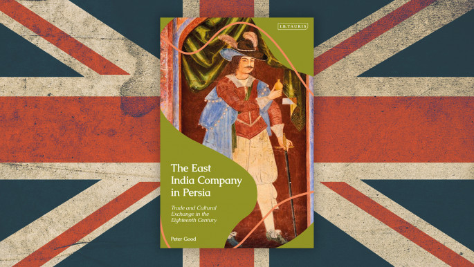
The British interest in the Persian Gulf had increased as India’s importance in the British imperial system increased in the 18th- and 19th-centuries.
In 1622, the British helped the Persian Emperor, Shah Abbas, in expelling the Portuguese from Hormuz Island in 1622.
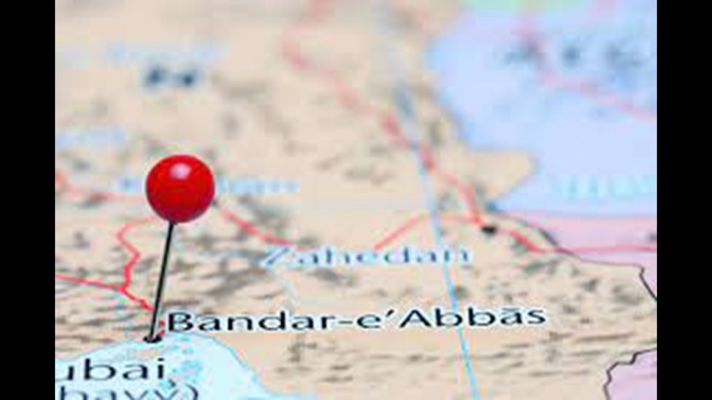
In return, the East India Company was allowed to establish a trading post in Bandar-e-Abbas on the southern coast of what is known as Iran today.
More on these two places, Hormuz Island and Bandar-e-Abbas, as we go through this region.
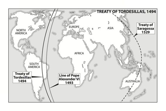
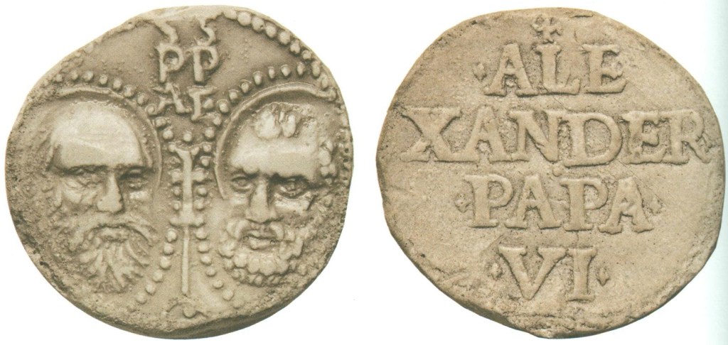
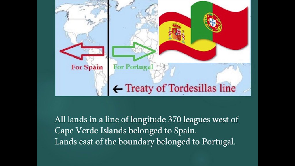
An important side-note here is that the Treaty of Tordesillas of 1494 divided the newly “discovered” lands outside Europe between the Portuguese Empire and the Spanish Empire (Crown of Castile), along a meridian 370 leagues west of the Cape Verde Islands, off the West Coast of Africa, one year after Pope Alexander VI had issued the Inter Cetera Bull in 1493, which essentially authorized the grab of the lands of the indigenous Moorish civilization.
Among other things, the bull assigned to Castile “the exclusive right to acquire territory, to trade in, or even approach the lands laying west of the meridian situated one hundred leagues west of the Azores and Cape Verde Islands, except for any lands actually possessed by any other Christian prince beyond this meridian prior to Christmas of 1492.”
Thirty-five-years later, the Treaty of Zaragoza was signed, which specified the Antimeridian to the line of demarcation specified by the Treaty of Tordesillas, defining the areas of Spanish and Portuguese influence in Asia, and used as the means to justify the colonize the world by the Spanish and Portuguese.
A “Papal Bull” is an official papal letter or document, named after the leaden seal used to authenticate it, and they figure prominently in the historical narrative we have been given.
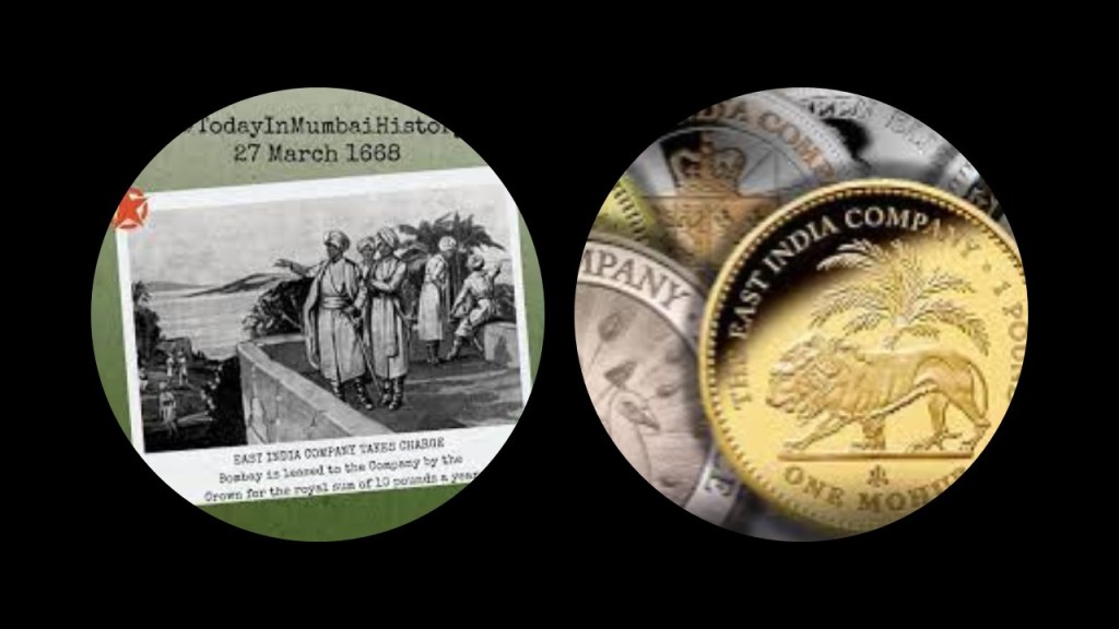
As a result of a series of Royal Charters granted by King Charles II, starting in 1661, the East India Company was granted the rights to autonomous territorial acquisitions; to mint money; to command fortresses and troops and form alliances; to make war and peace; and to exercise both civil and criminal jurisdiction over the acquired areas.
A royal charter was a formal grant issued by a monarch under “royal prerogative” as “letters patent,” and used early on as the means by which the British legitimized their colonization of the world.
“Royal prerogative” is a body of customary authority, privilege and immunity recognized in common and civil law jurisdictions within a monarchy as belonging to the sovereign that becomes widely vested in government, and the same idea as the Papal Bull, by which the authority to take land, among other things, was vested in one”Supreme Leader.”

Back to the Persian Gulf Residency.
The East India Company, as a result of the Royal Charters granted by King Charles II, became responsible for conducting British foreign policy in the Persian Gulf as the Crown’s regional agent.
The East India Company established their Residency at Bushehr, on the Persian Gulf, and another one later at Basar,
In 1822, the Bushehr and Basar Residencies were combined, and Bushehr became the headquarters for the new “British Resident of the Persian Gulf” of the British Colonial Residency.
A “Chief Political Officer” was the “Chief Executive Officer,” and was subordinate to the “Governor of Bombay until 1873, at which time this position became subordinate to the Governor-General of India until 1947, when India was granted its independence from Great Britain, at which time the responsibility was tranferred to the British Foreign Office.
The British terminated its protectorate and military presence in the Persian Gulf in December of 1971.

Now to apply this history back to the small, disputed island of Abu Musa.
Before 1908, the island had been under the rule of the Sheikh of Sharjah, now one of the United Arab Emirates but which had been one of the British “Trucial States.”
After the Sheikh had cancelled a 1906 mining concession he had awarded to three Arabs, for them to mine the red iron oxide deposits on Abu Musa because they turned around and offered to sell the extracted iron oxide to a German company, the British helped him expel the workers from the island but by 1908, the British came into control of the island.
In 1968, Britain announced it would be ending its military and administrative positions in the Persian Gulf.
Two days before the official establishment of the United Arab Emirates, on November 30th of 1971, the Sheikh of the Emirate of Sharjah signed a Memorandum of Understanding with Iran.
This MOU allowed Sharjah to have a police station on the island, and allowed Iran to station troops there, and divided the island’s energy resources between the two. This was supposed to preventing Iran from invading and taking over Abu Musa like it had the Greater and Lesser Tunb islands, two other disputed islands between the two coutnries.
However, on the same day of November 30th of 1971, a day before the British officially left the region, Iran moved its troops in and took over with the help of the Sheikh’s brother, and the dispute has existed ever since.
Just a couple more things about what I saw looking at photos of the island of Abu Musa before I move on from here.
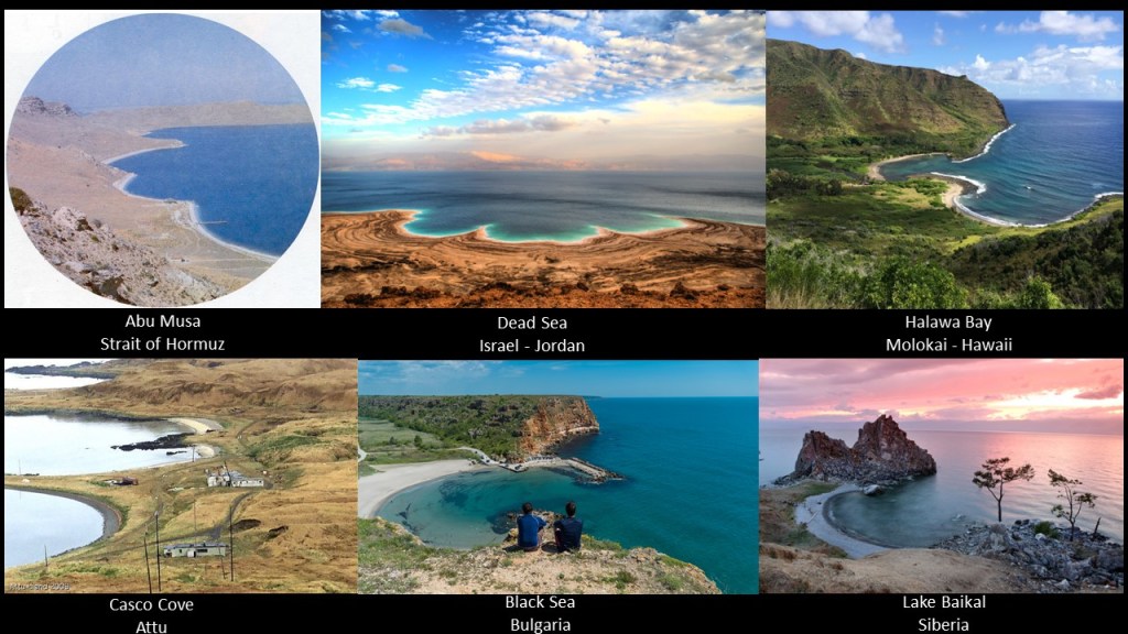
First, it has beaches with a symmetric curvature, as seen in this photo of Abu Musa on the top left, are features found in diverse places, like the Dead Sea in the top middle, which is located between Israel and Jordan; Halawa Bay on the top right, on the Hawaiian Island of Molokai; .Casco Cove on the island of Attu in the far-western part of the Aleutian Islands, on the bottom left; the Black Sea in Bulgaria, on the bottom middle; and and Lake Baikal in Siberia, on the bottom right.
Not sure exactly what we are seeing here, but there appears to be a pattern of some kind!
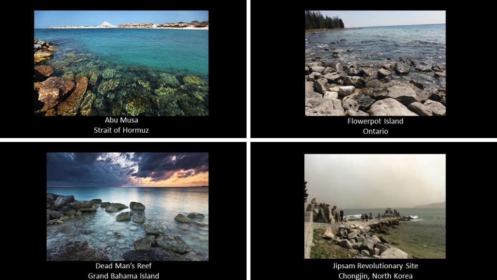
Another thing that Abu Musa has in common with other places are the presence of rocky shorelines.
How about this comparison of the rocks on the shore of Abu Musa on the top left with the shore of Flowerpot Island, an island in Georgian Bay in the Province of Ontario on the top right; on the bottom left, Deadman’s Reef on Bahama Beach, located at West End on the Grand Bahama Island, and on the bottom right, at the Jipsam Revolutionary Site in Chongjin, North Korea.
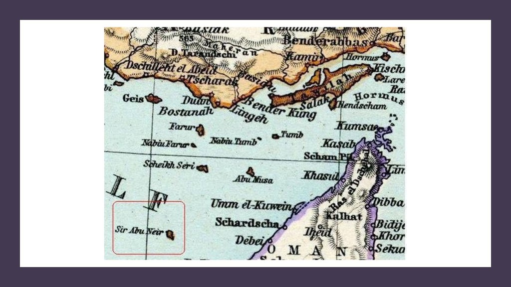
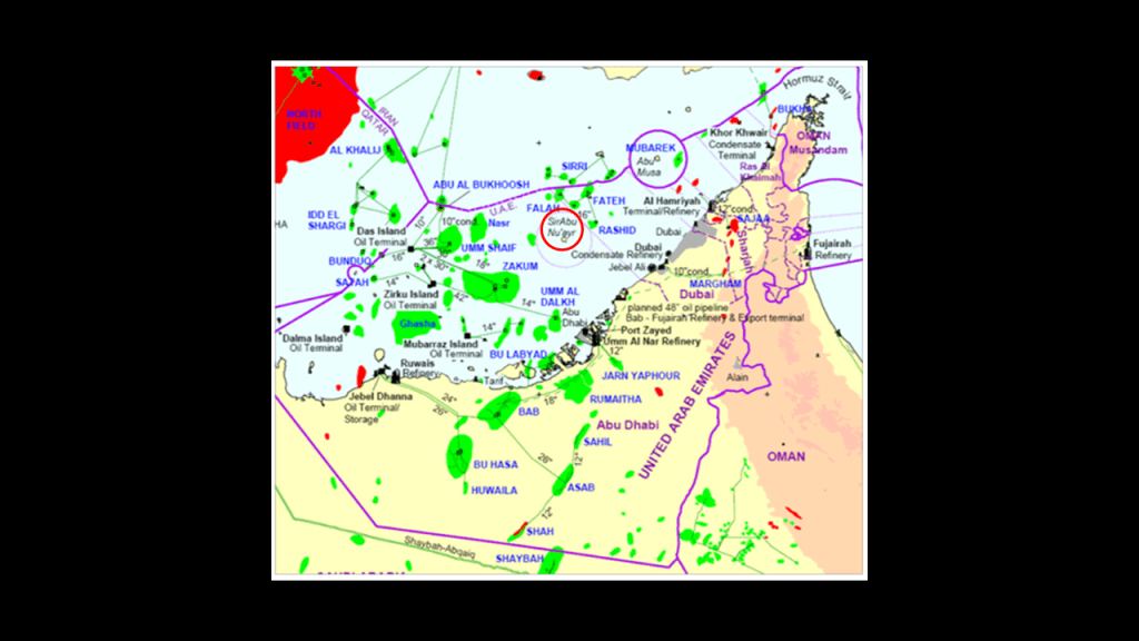
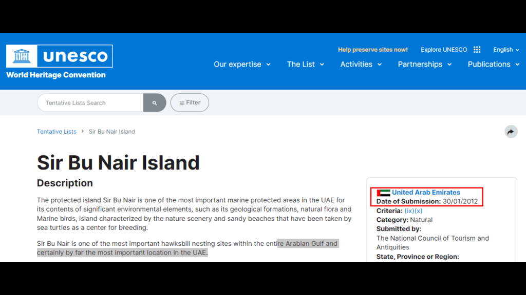
Next, I am going to take a look at the tiny island of Sir Abu Nu’ayr.
Sir Abu Nu’ayr does belong to the Emirate of Sharjah.
It lies 50-miles, or 80-kilometers, north of Abu Dhabi, and 64-miles, or 103-kilometers, west of Dubai in the Persian Gulf.
It is described as an almost perfectly round island, with a short-extension at one end, making it shaped like a droplet of water.
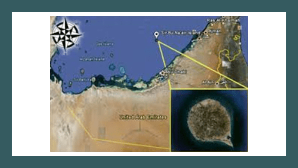
It has a small harbor and airfield located at the southeast end where the short-extension is located.
The island is said to be a “salt piercement structure,” or “salt dome,” formed by the movement from the Neoproterozoic to Early Cambrian Hormuz Formation Salt, with surface expressions of sedimentary, igneous rocks, and quartzitic sandstone.
To the north-northeast of the island is Dubai’s Fateh Oil Field complex; to the north is the Sirri Oil field of Iran; and to the west by the oil and gas fields of Abu Dhabi.
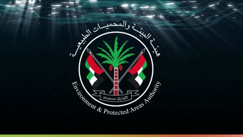
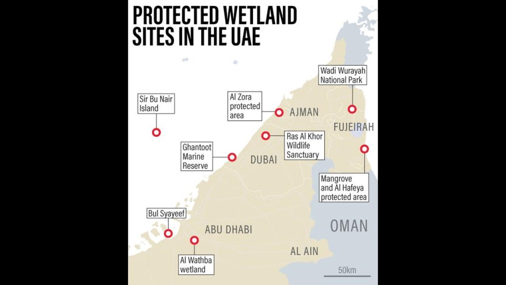
The tiny island of Sir Abu Nu’ayr is environmentally-protected under the “Sharjah Environment and Protected Areas Authority,” and is registered on the list of wetlands of international importance under the Ramsar Convention.
The Ramsar Convention was an international treaty that was first signed in February of 1971 in Ramsar, Iran, and is reviewed every three-years by the contracting international parties.
It designated sites, known as “Ramsar Sites,” to be considered of international importance when it comes to the conservation and sustainable use of wetlands.
As a matter of fact, the United Arab Emirates as a whole has eight Ramsar wetlands sites.
The Ramsar Convention defines wetlands as “areas of marsh, fen, peat, or water, whether natural or artificial, permanent or temporary, with water that is static or flowing, fresh, brackish or salt, including areas of marine water the depth of which at low tide, does not exceed 20-feet, or 6-meters.
In 2012, Sir Abu Nu’ayr it was listed as a potential UNESCO World Heritage Site.
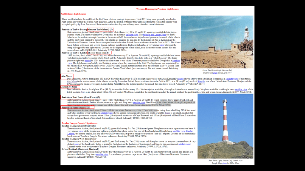
Next I am going to turn my attention to Iran’s Sirri and Farur Islands.
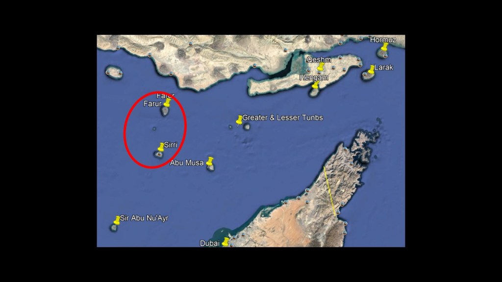
First Sirri.
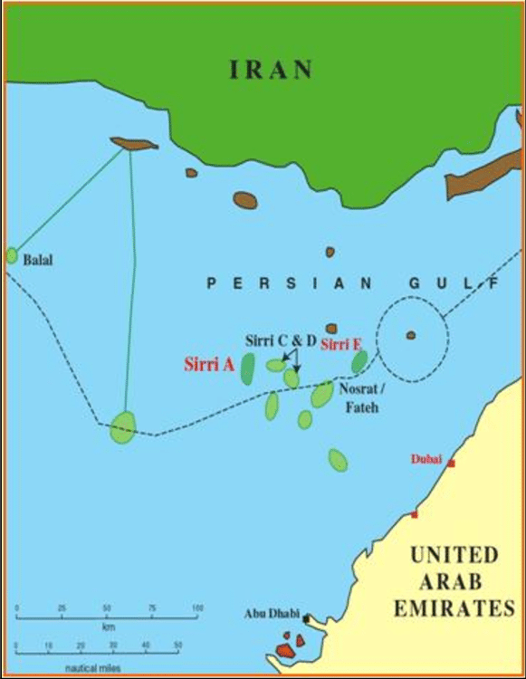
Sirri Island is one of six islands in the Abu Musa Island Group , and is located 31-miles, or 50-kilometers, west of Abu Musa, in the Hormozgan Province of Iran.
It is 3.5-miles, or 5.6-kilometers, wide, and 1.9-miles, or 3-kilometers, long.
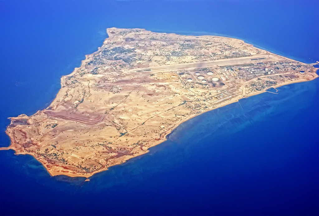
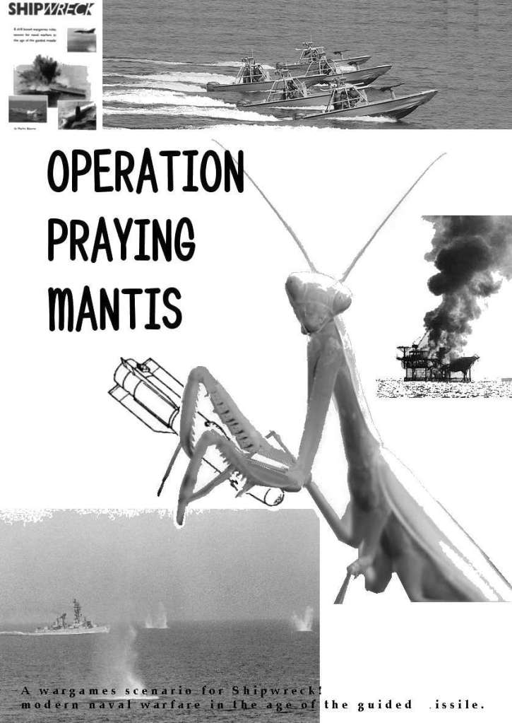
Sirri Island is the location of an oil platform that was reconstructed after having been destroyed by U. S. Naval operations during Operation Praying Mantis in April of 1988.
Operation Praying Mantis was a retaliatory attack against Iran because of an American warship that was damaged as a result of Iran mining International waters in the Persian Gulf during the Iran-Iraq War.
There are numeous offshore oil fields in the Sirri District.
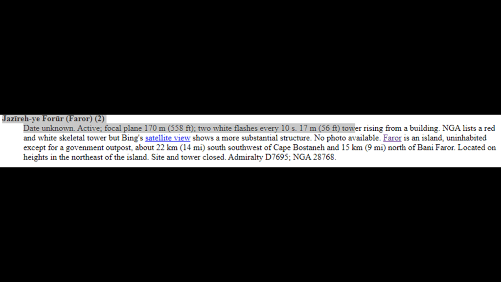
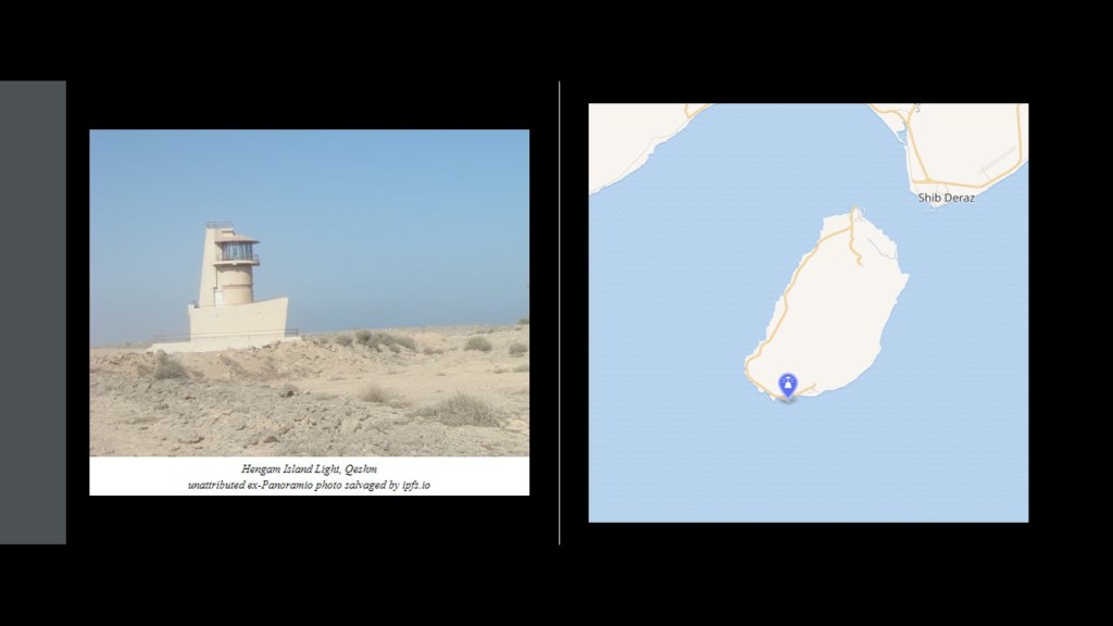
I saw where Sirri Island has a lighthouse, called the “Jazireh-ye Sirri” Lighthouse, but I was unable to find a picture of it.
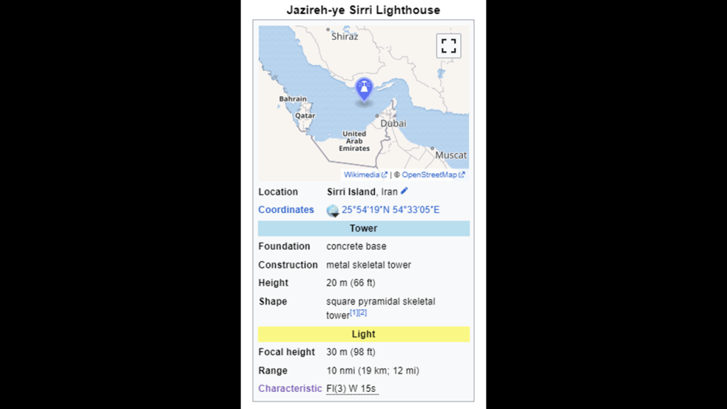
When I was looking for a picture of it, however, I found a reference to a present or past history of lighthouses on these islands we are looking at here.
I am not saying the following without having done a great deal of research on places with lighthouses and similar terrain and water features all over the Earth, based on what I am finding and seeing.
I don’t think the original purpose of lighthouses is what we are told.
Some may have been used as navigational aids for ships by the original civilization, like the lighthouses found at the entrances of harbors and ports, but I suspect “lighthouses” were quite literally referring to “a house for light” for the purposes of precisely distributing the energy generated by this gigantic integrated system that existed all over the Earth that was in perfect alignment with everything on Earth and in heaven.
Even the colossal “Statue of Liberty” was a lighthouse in Upper New York Bay, and utilized as such from November 1st of 1886 until March 1st of 1902 in our historical record.

They ended up becoming utilized as navigational aids, but I think that was because the land sheared off and sank right beside where they were located, creating the hidden conditions in the waters that the lighthouses became needed for.
I believe there was a worldwide subsidence of land-masses, and the simultaneous creation of estuaries, marshes, swamps, deserts, and dunes that happened relatively recently in our history as the result of a deliberately-caused cataclysm in a targeting of the Earth’s grid-system by the self-styled global elite class behind the New World Order, with ambitions of world domination and control driving their agenda, and that they occulted the timeline we are currently living on.
Next, Farur Island is close to Sirri Island, and is located 36-miles, or 58-kilometers, from Abu Musa.
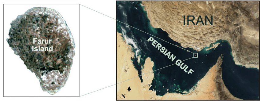
Currently uninhabited with the exception of some government officials that live there, it is said to have the remains of ruined buildings and water wells…and a lighthouse, though, like the one on neighboring Sirri Island, there is no photo of it.
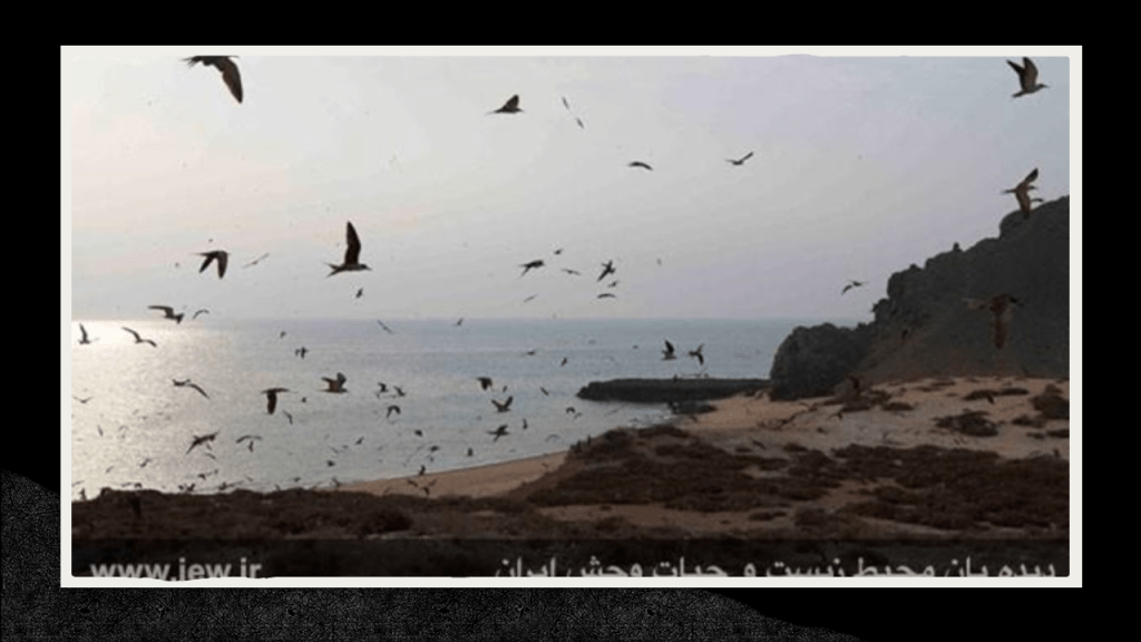
The Farur Island region is one of the richest wildlife regions in the country, and having things like a substantial bird population…
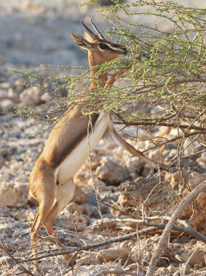
…and there is a subspecies of Arabian Gazelle on Farur that is considered a relict population that survived in isolation after having been split off from other Arabian gazelle populations.
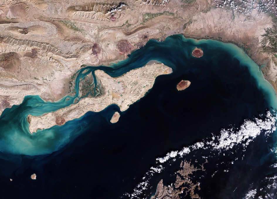
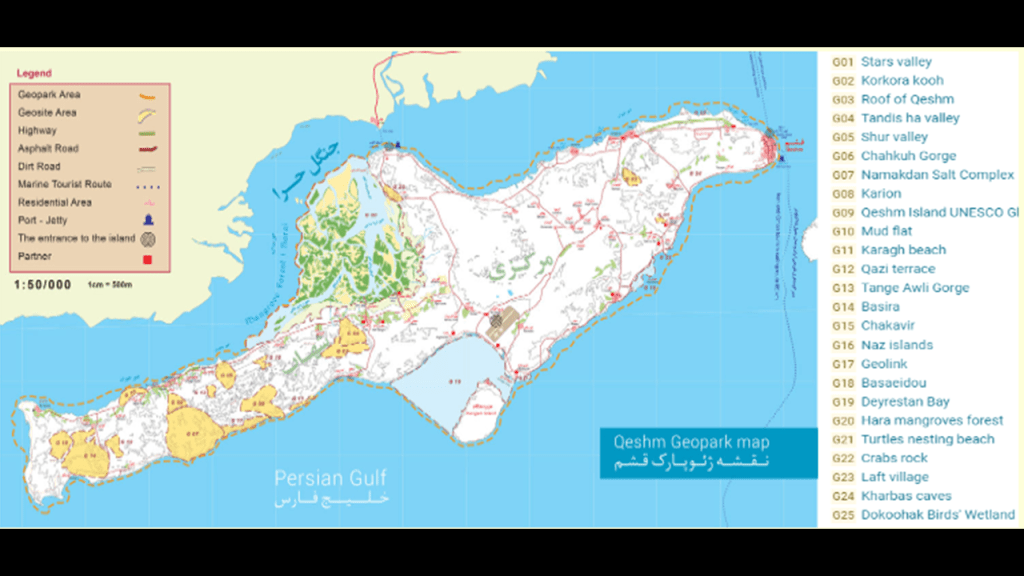
Now, I am going to turn my attention to the large island of Qeshm in the Strait of Hormuz.
It is the largest island in Iran, and one of the largest islands in the world.
An important trading center at one time, it is situated just a short distance off the coast of Iran.
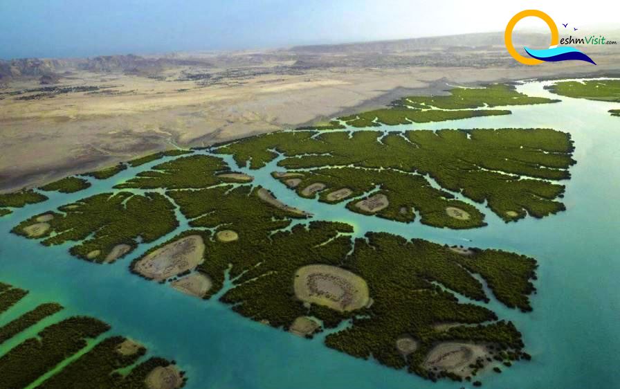
The narrow Clarence, or Khuran, Strait separates Qeshm from the mainland.
The Clarence Strait is the home to the most extensive location of mangrove trees in the Persian Gulf, the “Hara Forest,” and has been a protected Ramsar Site since 1975.
It is dominated by the species of Hara mangrove known as “white” or “grey,” and is found, like other mangrove trees, in the intertidal zones of estuaries, places where salt water meets freshwater; where the water is salty, dirty & unpleasant; where there are one or more rivers flowing into it; and where there is a connection to the open sea.
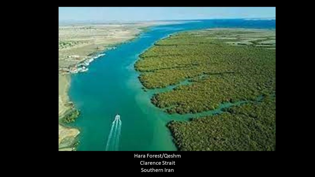
The Hara forest is comprised of floating mangrove trees…
…and the Hara Forest has many channels running throughout it.
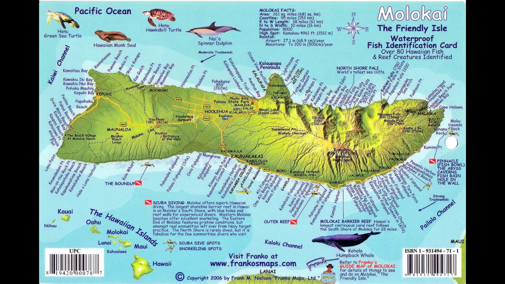
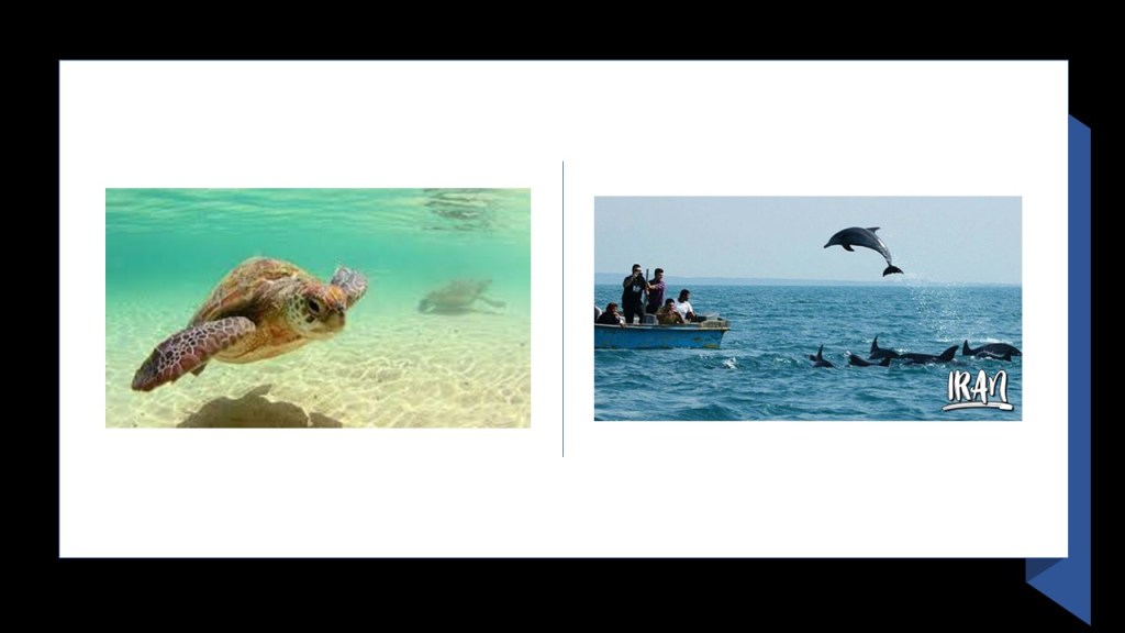
Qeshm Island on the top, like the Hawaiian Island of Molokai pictured below it, looks remarkably like the shape of…well…a dolphin… including land shaped like flukes and flippers.
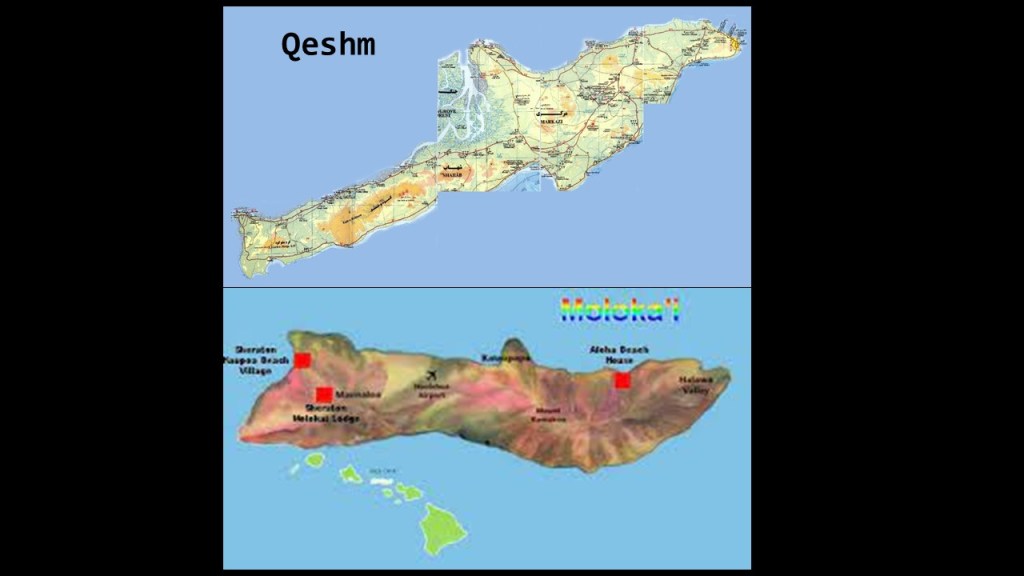
Not only do both of these islands look like dolphins, they both have a large population of sea animals in their waters, including large sea turtles and cetaceans like whales and dolphins.
Well, you might expect that in the Hawaiian Islands, but in Iran? In the Strait of Hormuz, the world’s biggest oil transit waterway “chokepoint?”
As a matter of fact, Qeshm has the earth’s largest mammal, the blue whale, swimming in its waters…
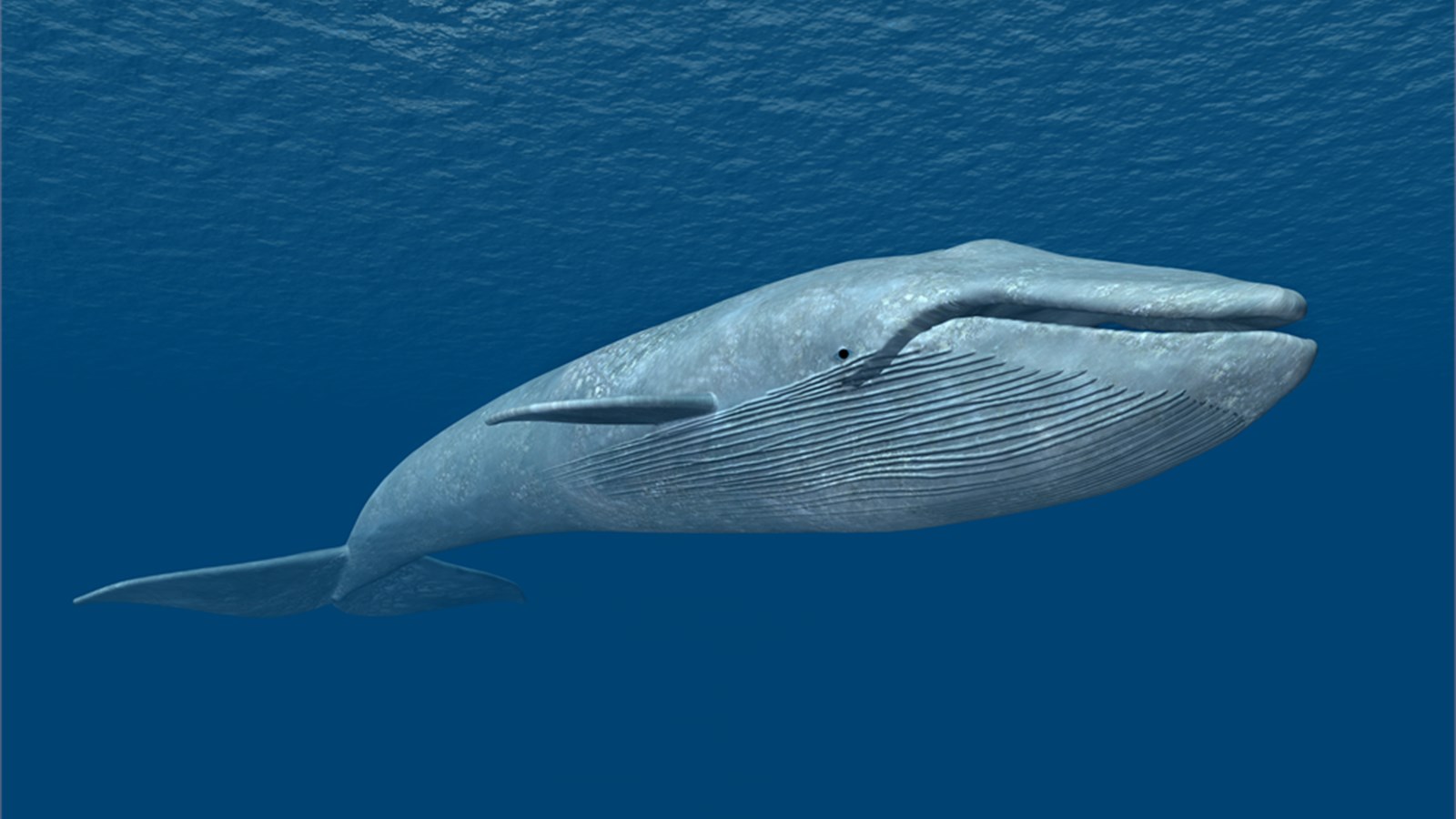
…as well as sea turtles and pods of dolphins that are also found in the waters around Qeshm.
The whole island of Qeshm was designated as a UNESCO Global Geopark in 2017.
It is said to be part of the southeastern portion of the Zagros Mountains, and part of the Hormuz Formation Salt plugs mentioned previously with respect to the tiny island of Sir Abu Nu’ayr.
Qeshm is called the Island of Seven Wonders, and along with the Hara Forest, some of these wonders include:
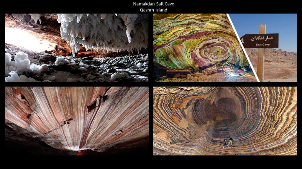
The Namakdan Salt Cave Complex on Qeshm, considered to be one of the world’s largest salt cave systems, if not the largest.
The cave system is said to be a 4-mile-, or 6.5-kilometer-, -long labyrinth, most of which is closed to the public.
This location is said to be therapeutic for treating asthma and other respiratory ailments.
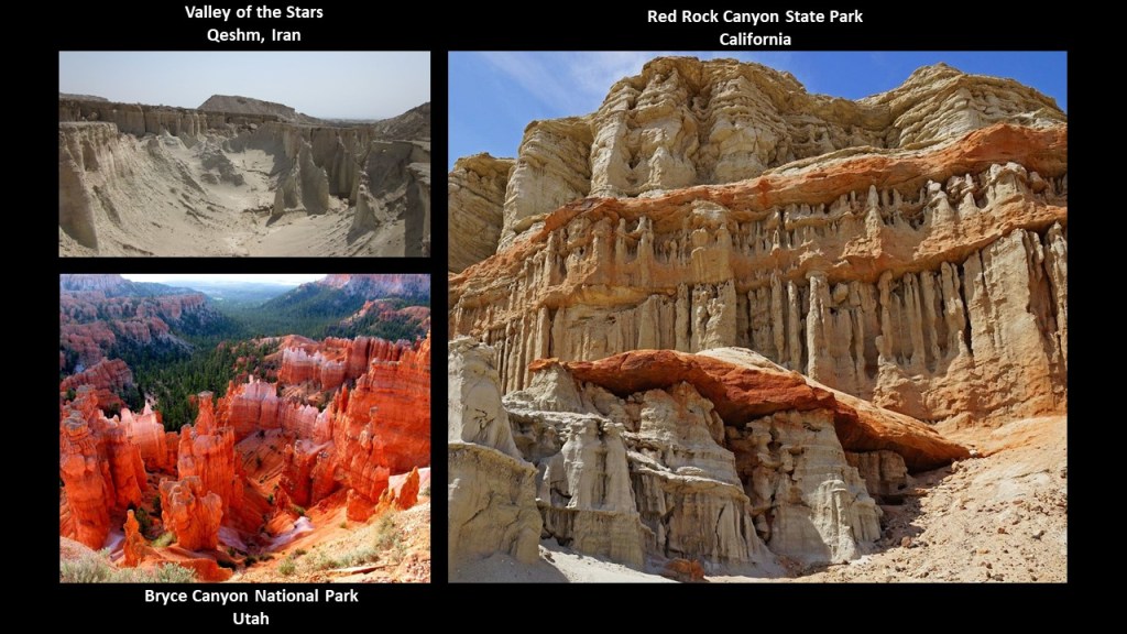
Another wonder on Qeshm is the Valley of the Stars, or Stars Valley, called one of the most amazing natural sites in the world.
But is it natural, or could that possibly be melted ancient masonry?
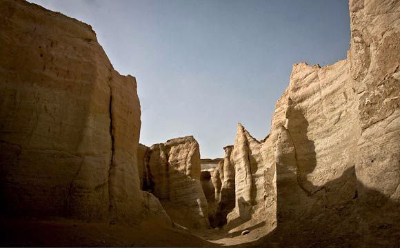
This view of the Valley of the Stars on Qeshm Island on the top left has a similar appearance to what’s found at Bryce Canyon National Park in Utah on the bottom left, and to Red Rock State Park in California on the right.
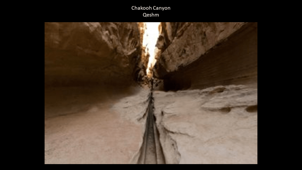
Another of the wonders on Qeshm is found at Chahkooh Canyon.
Here here we find what is described as the intersection of two vertical canyons.
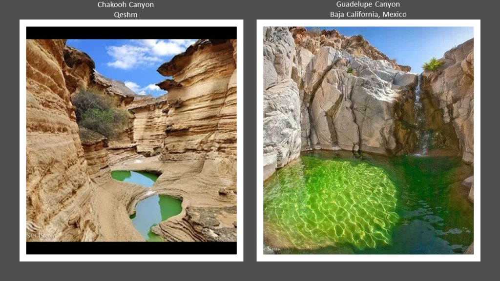
The color of the water in this view of Chakooh Canyon location on Qeshm Island on the left reminded me of the Emerald Pool in Guadelupe Canyon in Baja California, Mexico, on the right, a place that I found tracking a different long-distance alignment.
A few more things I would like to point out about Qeshm Island before I move on from here.
The Talla Wells on Qeshm are capable of holding water for a long time, keeping it healthy and cool.
The locals say in the past, the number of these cisterns equalled the number of days in the year, and every day, one of the wells was used for water.
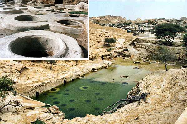
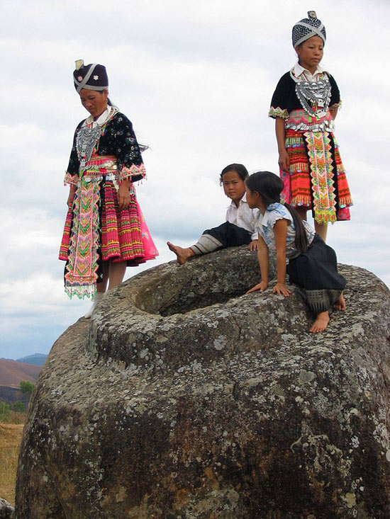
The Talla Wells reminded me of the Plain of Jars in Laos.
The Plain of Jars is a mystery, with thousands of huge jars cut from stone filling the landscape.
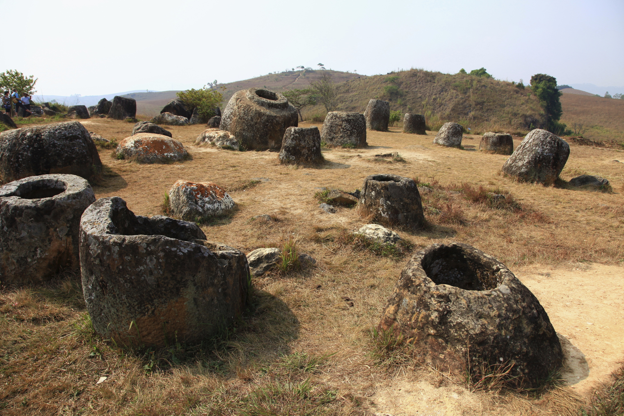
Some of the stone jars in Laos are massive in size!
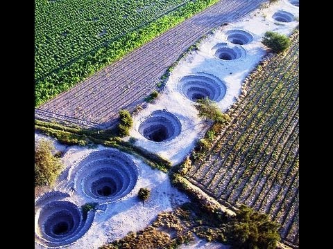
Other well systems in the world include the ancient Puquio Wells of Nazca in Peru.
This is a system of subterranean aqueducts, and most are still functioning.
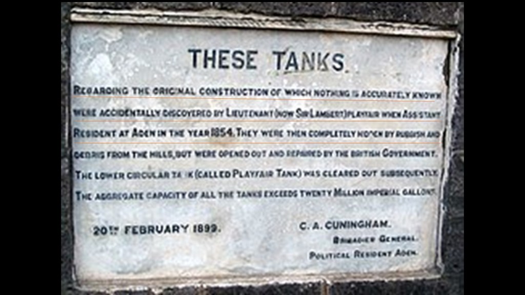
And in part 2 of this series, we saw the“Cisterns of Tawila” in the port city of Aden in southern Yemen.
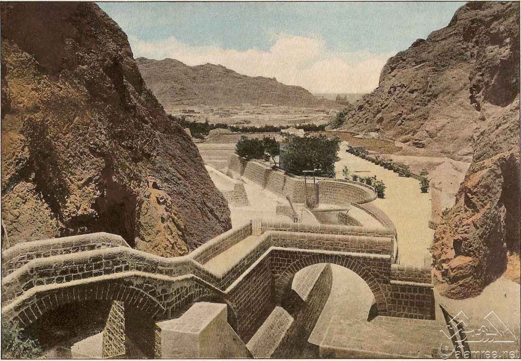
Interesting there is signage at the Cisterns saying that nothing was known about the original construction after they were “accidently” discovered by a British Officer in 1854.
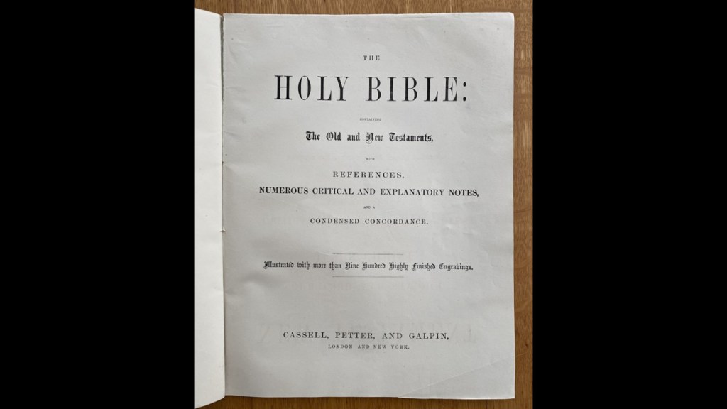
And like the vicinity around Aden in southern Yemen being a possible candidate for the biblical “Garden of Eden,” also mentioned in part 2 of this series, Qeshm was mentioned as a supposed site of the Garden of Eden in Cassell’s Bible.
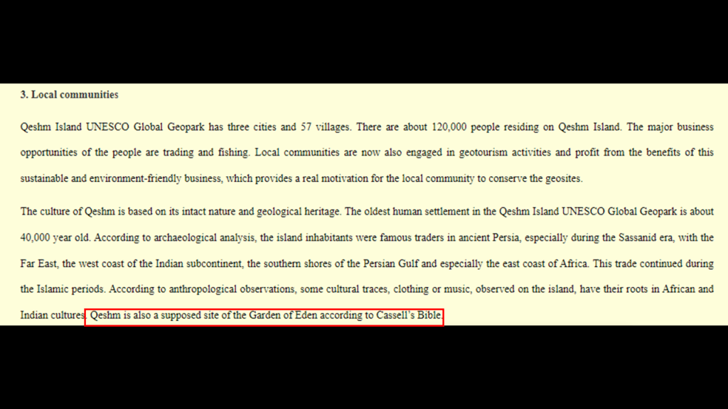
Cassell’s Bible was an illustrated version of the Bible first published in serialized format starting in 1859 and on through the 1870s, during which time it was published in sections for a certain price each section.
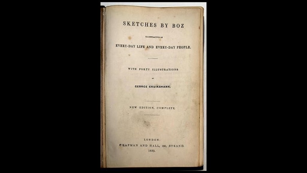
This way of publishing reading material for public consumption was typical during this time in both Great Britain and America, like Charles Dickens and “Sketches by Boz ~ Illustrative of Every Day Life and Every Day People,” a collection of short pieces Dickens published between 1833 and 1836 in different newspapers and periodicals…
…and Jack London, whose famous novel “Call of the Wild,” was first published in serialized form in “The Saturday Evening Post” in 1903.

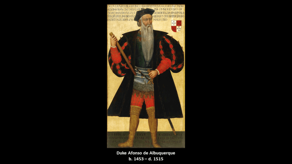
What is called the old Portuguese Castle, or Fort, on Qeshm was said to have been built by the Portuguese under Afonso de Albuquerque in 1507 as the “Fort of Our Lady of the Conception,” in order to manage an unforeseen insurgency by the locals, and mainly used as a warehouse for guns and artillery.
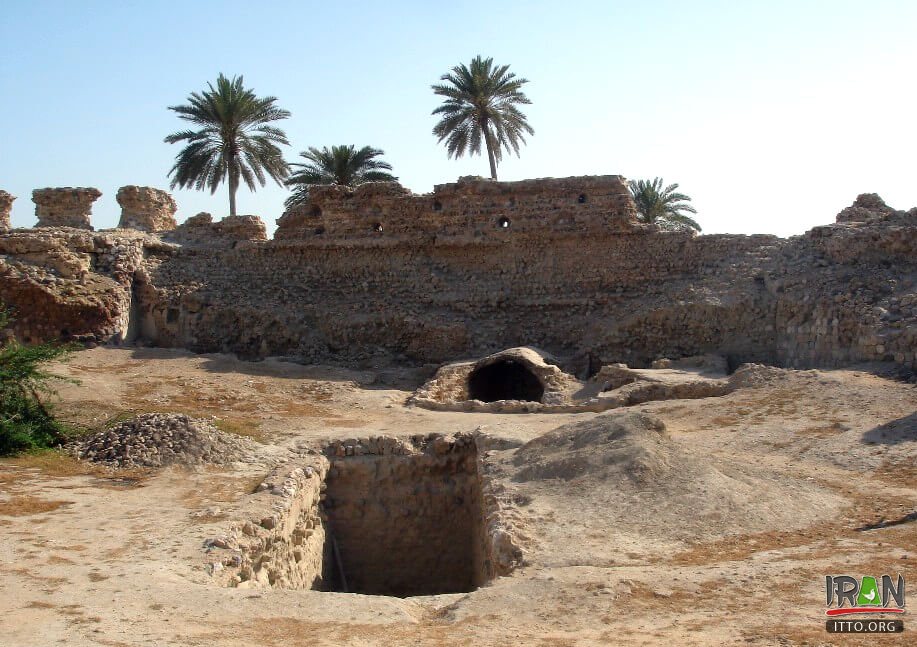
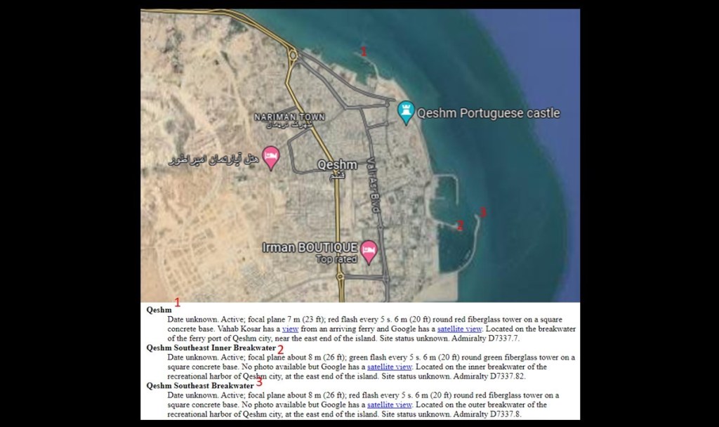
On the east end of Qeshm Island in the vicinity of the old Portuguese Castle/Fort are three lighthouses.
These lighthouses on Qeshm are at the entrances to artifically made harbors, so probably used as navigational aids for ships by the original civilization as harbor guides on top of whatever other function they might have had.
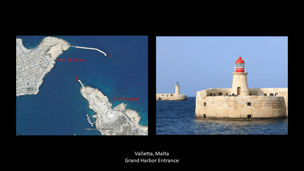
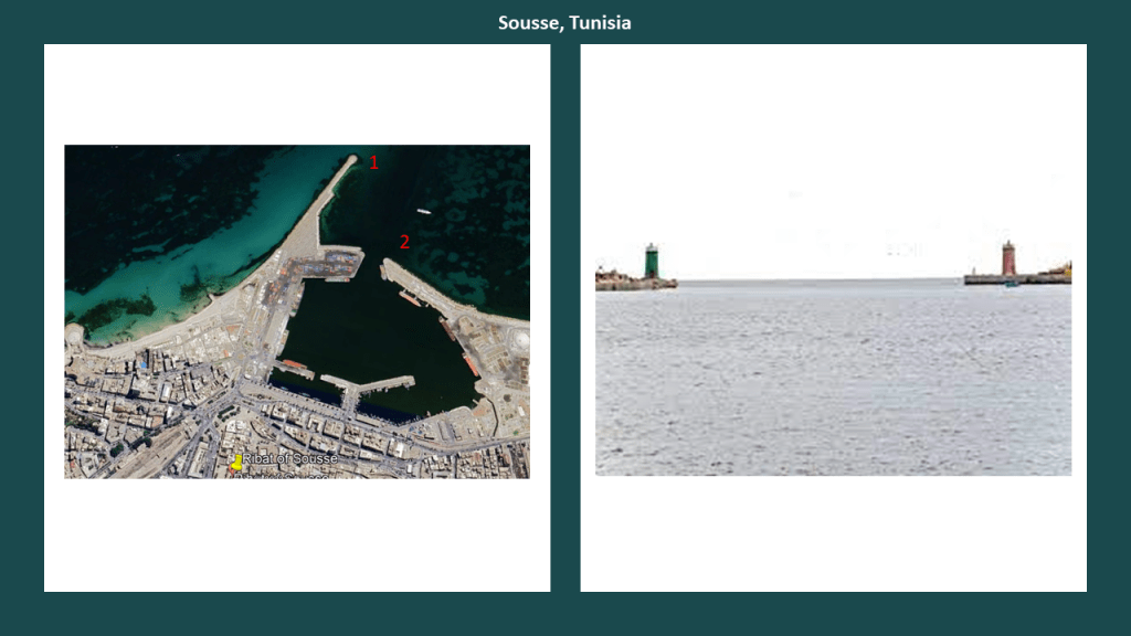
Other places I have found where lighthouses are located at harbor/port entrances in a similar configuration as Qeshm are at the Grand Harbor in Valletta, Malta, with Fort St. Elmo on one side, and Fort Ricasoli on the other…
…at the harbor entrance in Sousse,Tunisia, not far from the historical location of Carthage near the country’s capital at Tunis.
The Ribat of Sousse is an historical fortification in Sousse, near the harbor.
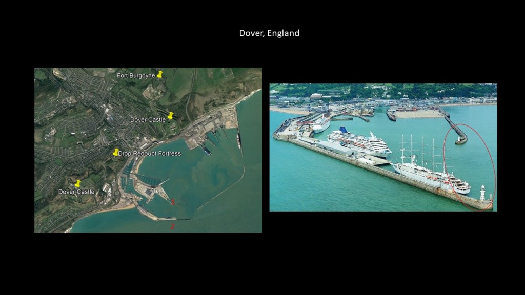
I found the same configuration of lighthouses at the entrance to the Port of Dover, England, in the English Channel, which has several fortifications nearby, like the sprawling Dover Castle; Drop Redoubt Fortress; and Fort Burgoyne.
Like lighthouses, I think these so-called forts served some kind of energy function on the Earth’s grid system.
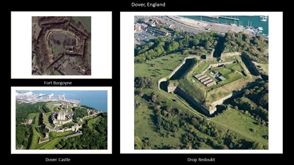
Perhaps as batteries, as they are so often called, like these in Hobart, Tasmania.
I typically find these in pairs or clusters as well, all over the Earth.
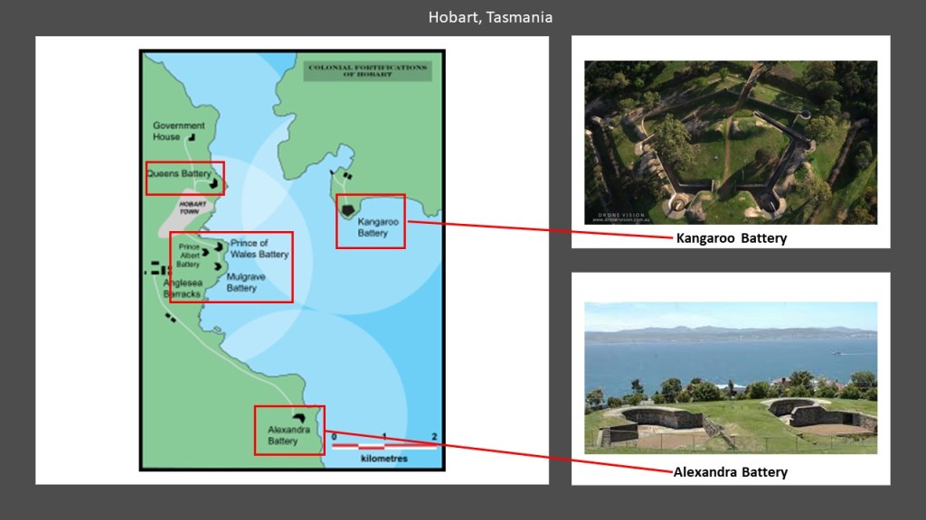
A battery is a device that produces electricity that may have several primary or secondary cells arranged in parallel or series, as well as a battery source of energy which provides a push, or a voltage, of energy to get the current flowing in a circuit.

There is one more thing I would like to point out before I leave the beautiful island of Qeshm, which is in a free zone, so a visa is not required to visit.
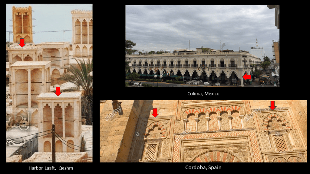
This photo is of Harbor Laaft on Qeshm.
These buildings most definitely have Moorish architectural features.
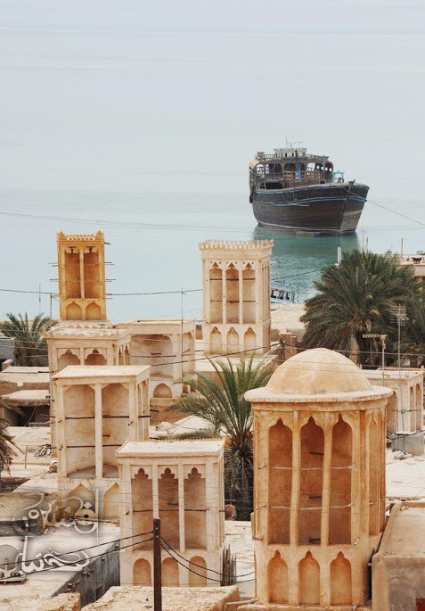
To support what I am saying, here are photos of five-lobed Moorish arches in Harbor Laaft on Qeshm on the top left; the Hotel Ceballos in Colima, Mexico on the top right, and of five-lobed arches in Cordoba, Spain, which is acknowledged Moorish architecture, the bottom right.
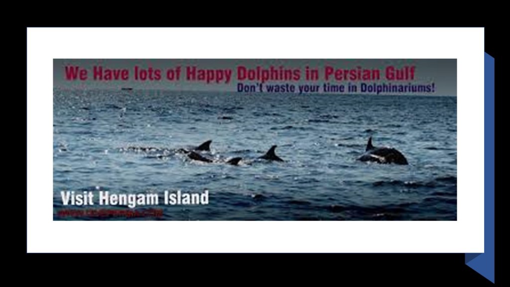
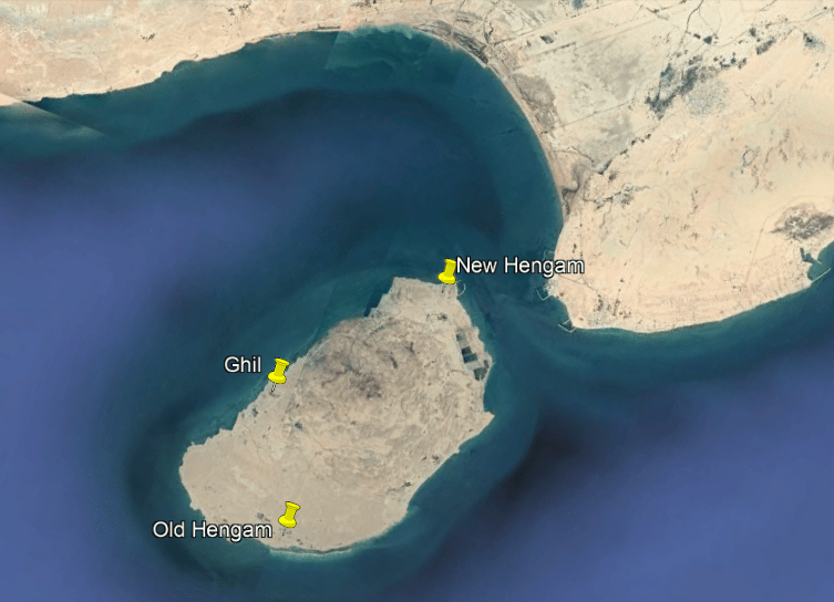
Next, the island of Hengam is located just south of Qeshm, holding the position of what looks like a flipper that broke off from the main body of the dolphin-shaped island.
Hengam is called the “Island (or Home) of the Dolphins.”
It has three villages – Old Hengam, New Hengam, and Ghil – but doesn’t have cars or paved roads.
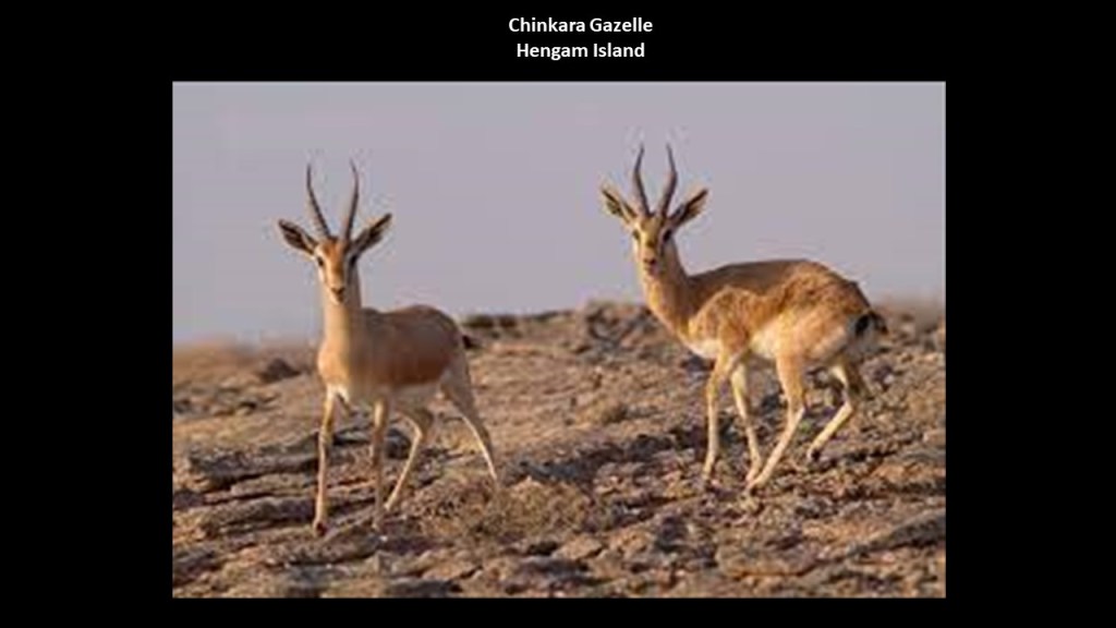
Besides the dolphin population around Hengam’s waters, the island itself is home to a species of Persian gazelle that is native to Iran known as the Chinkara…
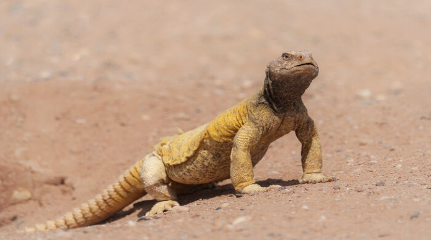
…as well as a species of large, spiny-tailed lizard known as the Egyptian Uromastyx…
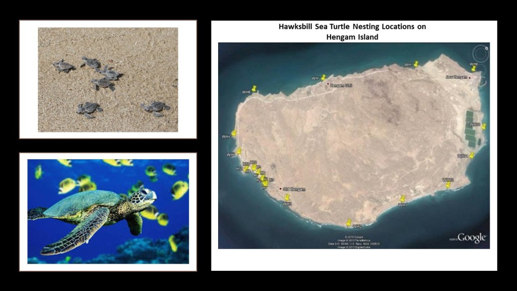
…and is one of several locations throughout this region where hawksbill sea turtles are found and have their nests.
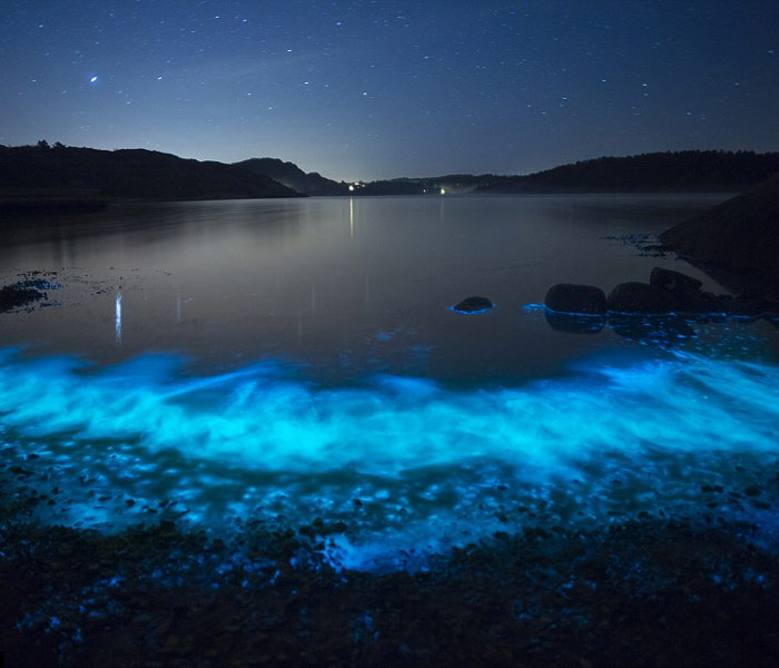
Hengam is also known for its glowing blue sea from phytoplankton at night when the water is calm and windless.
Like Qeshm and other islands we have seen here, Hengam also has a lighthouse.
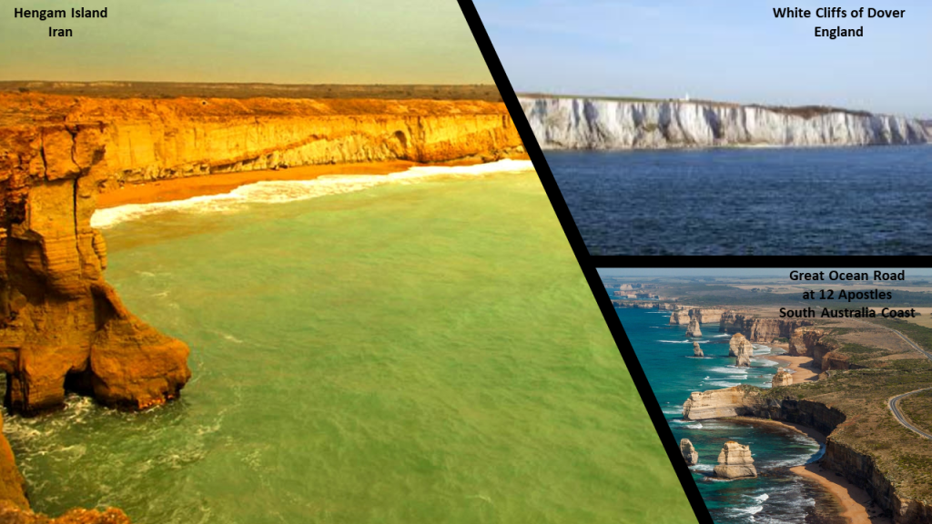
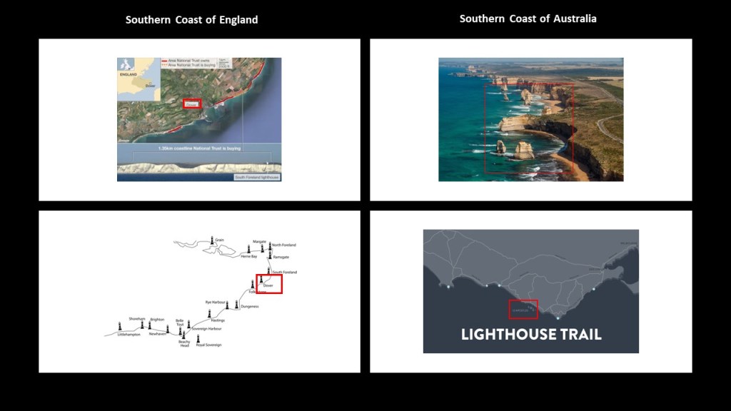
Hengam also has an intriguing-looking coast.
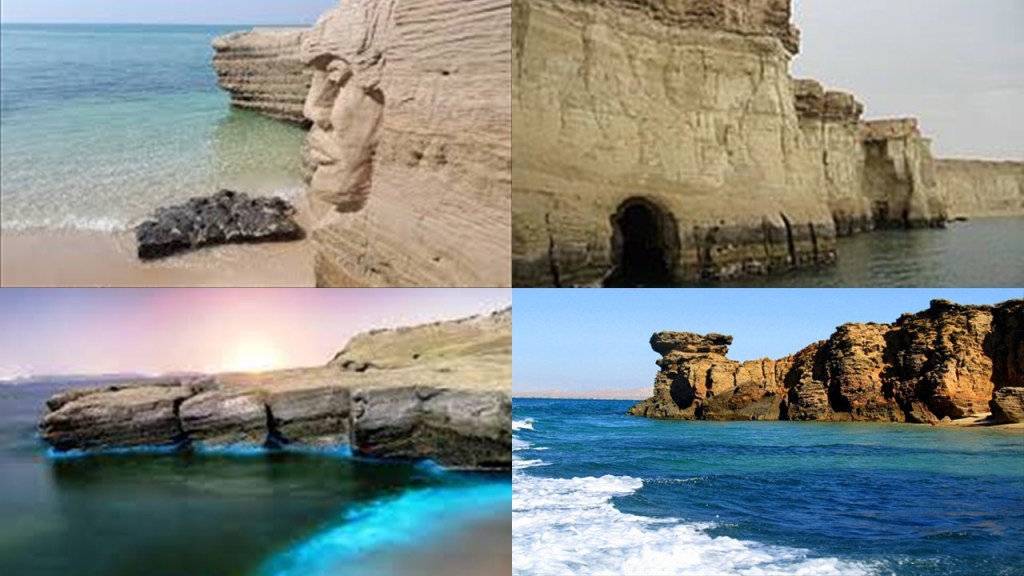
So, for purposes of comparison, here is a view of sheer cliffs along Hengam Island’s coastline on the left, compared for similarity of appearance with the sheer white cliffs of Dover on the coast of southern England on the top right, and the cliffs along the southern coast of Australia in Victoria State where the Great Ocean Road runs for a long distance next to a sheer cliff, and showing the location of the 12 Apostles, then name given to what are called “limestone stacks” in the water off Port Campbell.
When the word “sheer” is used to refer to a cliff, it means a high area of land with a very steep side.

One of the meanings of the word “shear” spelled with an “a” is to break off, or be cut off, sharply.

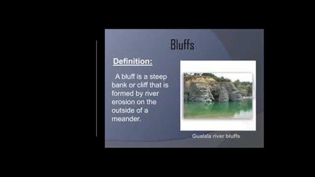
A synonym of the word for “sheer cliff” is “bluff.”
Another meaning of the word “bluff” is a deception, or an attempt to deceive.

Here are two of countless examples I have found of why I believe there is a connection about between the lighthouses and land-subsidence.
On the left-side is the rugged coast of southern England, where the “White Cliffs of Dover” are located, and a map showing corresponding lighthouses locations along the coast, and on the right side is a picture of the cliffs along the coast of Victoria State in southern Australia, where the Great Ocean Road passes by the 12 Apostles and the corresponding lighthouses beside the cliff-edge there.
As I mentioned earlier in this post, I have come to believe that lighthouses originally had a different function on the Earth’s grid system having to do with light energy, and ended-up becoming utilized as navigational aids in our world because the land sheared-off and sank right beside where they were located, creating the hidden conditions in the waters that the lighthouses subsequently became needed for, because of a deliberately deliberately-caused cataclysm involving the Earth’s grid-system, that also simultaneously created estuaries, marshes, swamps, deserts and dunes, and that this happened relatively recently in our history by the self-styled global elite class behind the New World Order, with ambitions of world domination and control driving their agenda and bringing us the crazy, upside-down world we live in today, with a new historical narrative and a new timeline that was occulted.
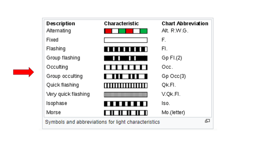
Coincidentally (or not), the word “occulting” is used to describe a type of lighthouse light-characteristic pattern.
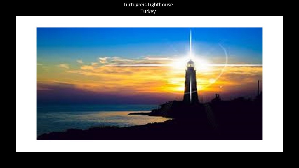
This is an intriguing photo I came across earlier this year of the lighthouse at Turtugreis in Turkey.
There are many reasons I have come to believe that lighthouses were originally connected with light energy and its distribution in the Earth’s energy grid system.
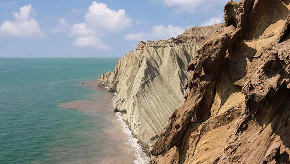
The last place I want to introduce you to in this part of the series about the Strait of Hormuz, is Hormuz Island.
Like what we saw with little island of Sir Abu Nu’ayr awhile back in this post, Hormuz Island is also an almost perfectly round island, with a short-extension at one end, making it a water-droplet-shaped island.
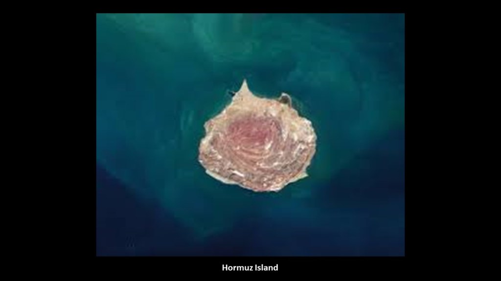
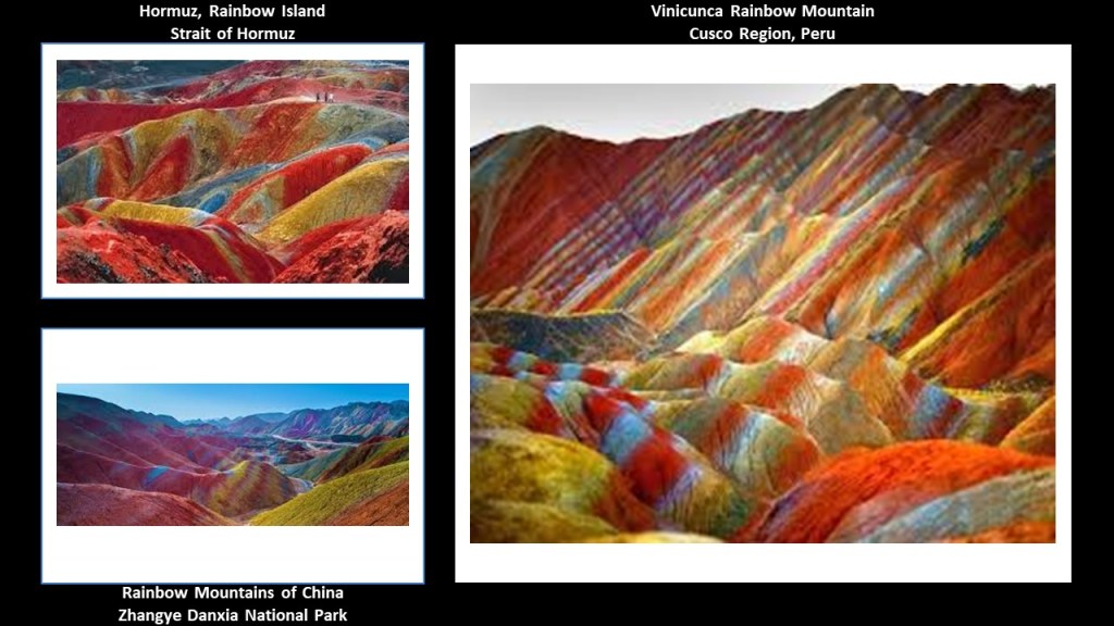
Hormuz Island is called the “Rainbow Island of Iran.”
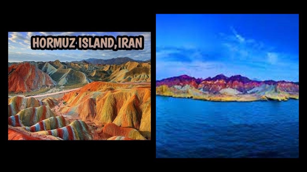
It is interesting to note that note that other places in the world that have rainbow colors similar to Hormuz Island on the top left include, Vinicunca, the rainbow mountain in the Cusco region of Peru on the right, and the Rainbow Mountains in the Zhangye Danxia National Park in China on the bottom left.
Here are some places to visit on Hormuz Island.
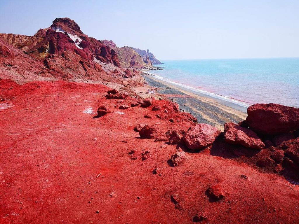
What is known as “Red Beach” is said to get its color from a soil rich in red iron oxide, which is a valuable mineral used not only for industrial purposes but also in local spices and jams.
The Valley of the Statues on Hormuz Island has rock-shapes likened to animal-forms…
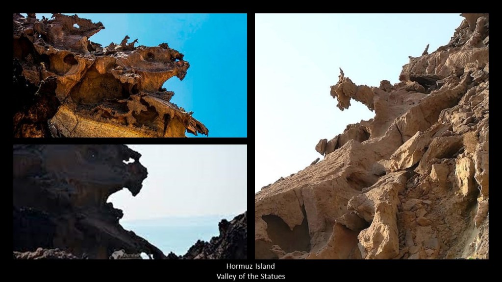
…and where there are “sheer cliffs” next to the coast of the island.
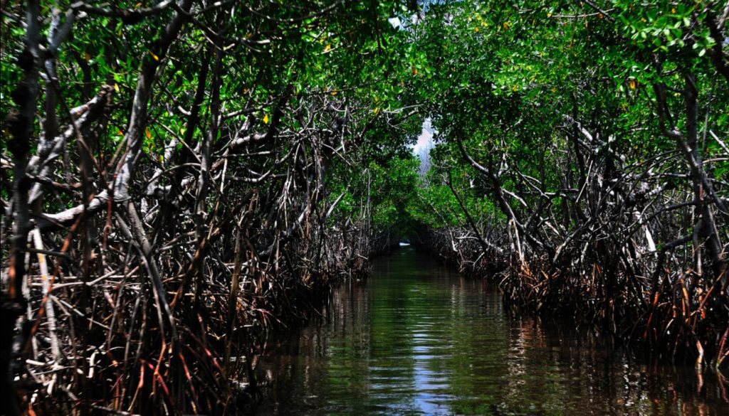
Like Qeshm, Hormuz Island has a Mangrove forest…
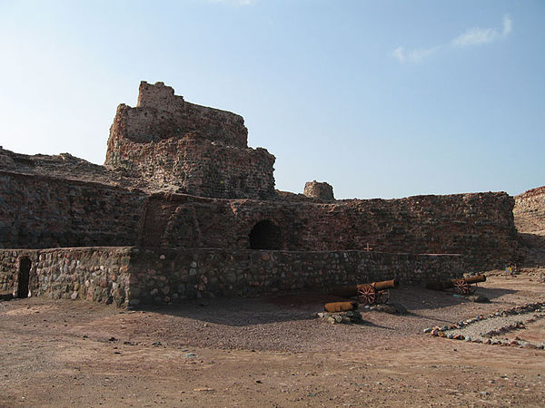
…and an old Portuguese fort, also said to have been built by the Portuguese Duke Alfonso de Albuquerque after he captured the island in 1507, and also known as the Fort of Our Lady of the Conception, and became part of the greater Portuguese Empire.
This is a good place to revisit the Treaty of Tordesillas of 1494, which divided the newly “discovered” lands outside Europe between the Portuguese Empire and the Spanish Empire, one year after Pope Alexander VI had issued the Inter Cetera Bull in 1493, which essentially authorized the grab of the lands of the indigenous Moorish civilization.
This is what we are told in our historical narrative.
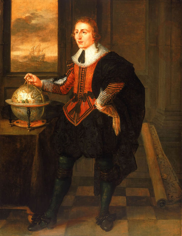
First, Duke Afonso de Albuquerque.
He has gone down in our history as a great Portuguese general, admiral, and statesman.
He was Viceroy of Portuguese India from 1509 to 1515.
Besides capturing the forts on Qeshm and Hormuz in 1507, he led Portuguese forces in the Conquest of Goa in 1510, and captured the city of Malacca in the Strait of Malacca in Indonesia in 1511.
Among other goals of conquest, he sought to secure the spice trade for the Portuguese Empire, which include control of Malacca in the Spice Islands; Goa in India: Hormuz in the Strait of Hormuz; and the port city of Aden in Yemen on the Gulf of Aden near the Red Sea that we saw in the last part of this series.
There is another papal bull to bring up here.
It was the one that was issued by Pope Paul III in 1540, by which he established the Jesuit Order under the leadership of Ignatius Loyola, a Basque nobleman from the Pyrenees in Northern Spain. and Francis Xavier, a Spaniard who became a representative of the Portuguese Empire in Asia, was a co-founder of the order.
The Jesuit Order included a special vow of obedience to the Pope in matters of mission direction and assignment.

No sooner than the Jesuits had been established in 1540, Francis Xavier was on his way to Goa in India from Lisbon in 1541, arriving there in May of 1542, for the stated reason of spreading the message of Jesus.
He has a dark legacy there even though his name came to be revered worldwide.
The inquisition started functioning in Portugal in 1541, and Francis Xavier laid the foundation for the Inquisition to be established in Goa after he arrived there in order to impose the Catholic Church’s policies and mass conversion on the population there.
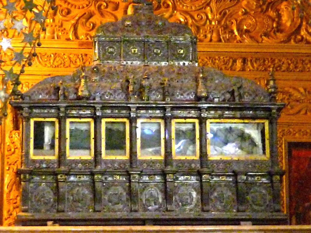
He died in China in 1552, and in December of 1553, his body was shipped to Goa, where he was subsequently placed in a glass container encased by a silver casket in Goa’s Basilica of Born Jesus, where his remains are to this day.
There are 32 silver plates on every side of the casket depicting episodes from his life.
Francis Xavier was beatified in October of 1619 by Pope Paul V, and canonized as a saint by Pope Gregory XV in March of 1622.

Twenty-years after the establishment of the Jesuits and Francis Xavier’s arrival in Goa, the Goa Inquisition officially started in 1561 as an extension of the Portuguese Inquisition in Portuguese India in order to enforce Catholic Orthodoxy and an allegiance to the Pope.
It was considered to be one of the worst inquisitions in human history, with more than 2,000 people burned alive, and many more than that tortured.

In our historical narrative, the same year of 1622 that Jesuit missionary Francis Xavier was canonized as a saint, the Portuguese lost Hormuz Island to the forces of the British East India Company allied with the Persians, who had successfully re-captured the forts at Hormuz Island and Qeshm.
English explorer William Baffin was in the service of the East India Company when he died of wounds sustained during the Capture of Hormuz.
Baffin Bay between Greenland and Canada, and Baffin Island in Canada, are named after him.
I personally have a lot of questions about the veracity of what our historical narrative tells us about the history of this time period because of the number of early Portuguese explorers, for example, that I came across that had their first biographies written by German and English Biographers in the 19th-century.

Please see my blog post “Evidence for the Manipulation of Space and Time & the Creation of a New Timeline for the Earth” for an in-depth look at this subject.
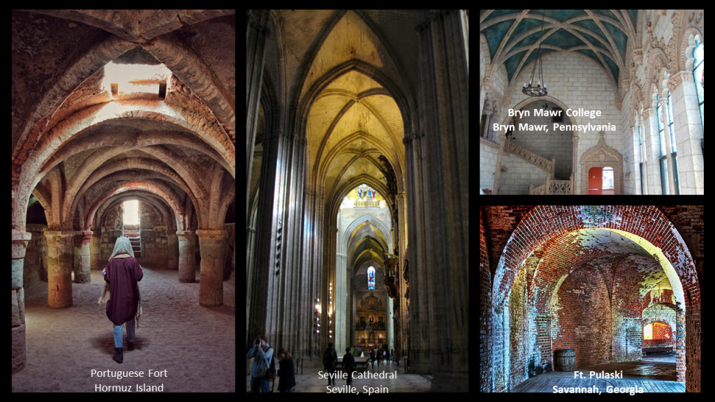
Here is a photo of the vaulted arches of the Portuguese fort on Hormuz on the left; compared with the vaulted arches of the Seville Cathedral in the capital of Moorish Spain, in the middle; and on the top right is the “Spanish Gothic” architecture at Bryn Mawr College in PA that was torn down about 15-years ago, with its vaulted ceiling, and five-lobed Moorish arches; and the vaulted archways at Ft. Pulaski in Savannah, Georgia, on the bottom right.
While we are taught all of these architectural similarities were occurring at different times across countries and continents during centuries when, according to what we are also taught in history class, transportation was limited and communication was regional.
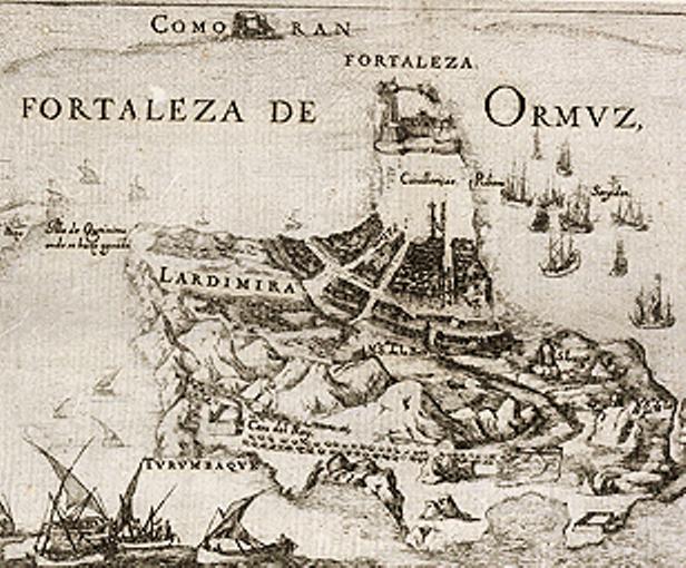
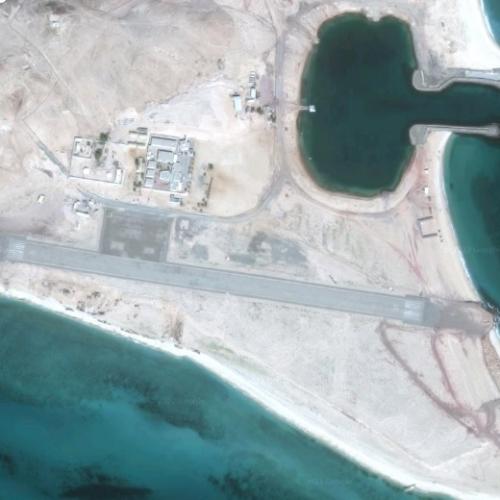
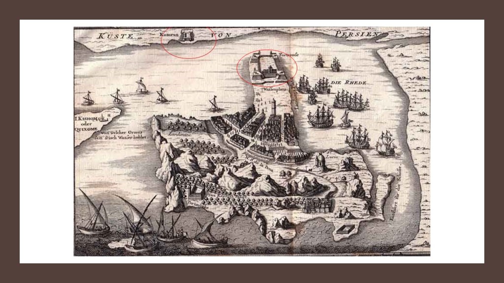
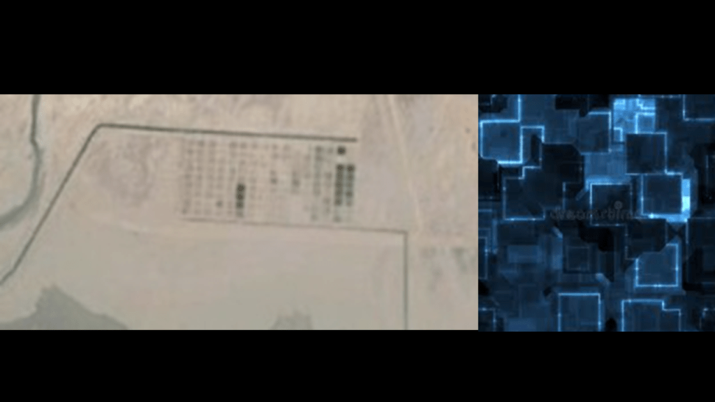
The date given for this old map of Hormuz is 1747, showing lots of activity going on here, and what appears to be another star fort shape across the Strait of Hormuz on the coast of what is now southern Iran.
While on Google Earth there no longer appears to be a similar structure across the water in this location…
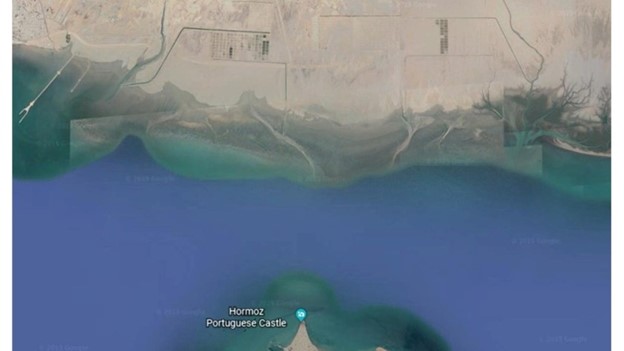
…there does appear to be an intentional configuration of many square shapes in the desert in that location in a close-up shot on the left that are reminiscent of circuitry chips on a circuit board on the right.
As always, there is more here than what I have shared, but this serves as an introduction to an obscure, but fascinating, place on the Earth.
I will pick up the alignment on the coast of southern Iran in the port city of Bandar-e-Abbas in the next part of the series.