
So far I have tracked this circle alignment from its starting point in North Africa in Algiers, Algeria, through Mali, Guinea, Brazil, Colombia, Panama, Nicaragua, Honduras, Belize and Mexico.
Now the alignment enters the United States in Louisiana.
As I said at the end of the last post, the alignment is moving into the Heart of the Empire Washitaw of the Washitaw Mu’urs, also known as the Ancient Ones, and the Mound Builders.
The Ancient Ones don’t refer to a people that existed a long time ago. It refers to an Ancient People that are living in the present day.
The United Nations recognized the Washitaw Mu’urs as the Oldest Indigenous Civilization on Earth in 1993.

The Washitaw existed far, far back in time, way far, at least as far back as the time of Mu, hence their identification as Mu’urs. Empresses are the ancestral rulers of the Washitaw Empire.
The Washitaw were also called the Ouachita, Wichita, Choctaw, Etowah, Eutaw, Waseti, Waxhaw, Hatchita, Washoe, Uaxactun, to name a few variations of the name. There are many, many other Native American tribes that are also Washitaw, but are considered to be separate from them because of the historical hatchet job that was done to remove the Ancient Ones from the historical record, and to misdirect and misinform.

The Mississippi River Delta is nearby, southeast of Baton Rouge – close to the alignment, as is New Orleans – but not directly on it, like Baton Rouge.
Throughout this post, I will provide reasons why I believe there is an inverse, and intentionally-mirrored relationship between the Mississippi River region and the Nile River region in Africa.
To begin with, I have drawn a red line on this world map to demonstrate that there is a straight, west-to-east, linear relationship between the location of the Mississippi River Delta, and that of the Nile River Delta.

The Mississippi River, also known as the “Father of Waters,” flows southward 2,320 miles, or 3,730 kilometers…

… from its source at Lake Itasca in Minnesota, not far from Lake Superior, and the Great Lakes Region of North America…

…to the Mississippi Delta in southeastern Louisiana.

The Nile River, also known as the “Father of African Rivers,” and along with its major tributary, the White Nile, is 4,130 miles, or 6,650 kilometers, long.

The source of the White Nile is Lake Victoria, in what is called the Great Lakes Region of Central Africa.

The source of the Blue Nile is Lake Tana, a sacred lake in Ethiopia, and it joins the White Nile to become the Nile at Khartoum, the capital of Sudan.

From Khartoum, the Nile flows northward to the Nile Delta.

Here is a side-by-side comparison of the Mississippi River and the Nile River…

…as well as what the Mississippi River Delta and the Nile River Delta look like together in person.
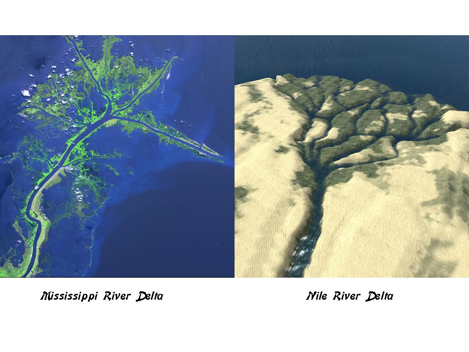
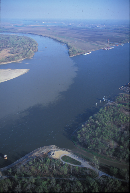
This is an aerial view of the Mississippi Delta, which is on the southeastern coast of Louisiana, showing many geometric and straight channels…

….and the same type of straight, geometric channel is also found in the Nile Delta.

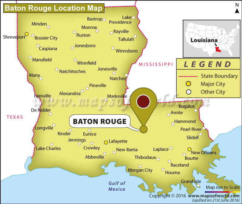
Now to the actual alignment, the first major city we come to being Baton Rouge, Louisiana. Baton Rouge is the State Capital of Louisiana, and its second-largest city.
There are two particular places in Baton Rouge that I would like to highlight.
The first are acknowledged ancient mounds at Louisiana State University in Baton Rouge. There are two mounds there, believed to be more than 5,000 years old, and considered to be part of the oldest mound system in North America, and part of an acknowledged Louisiana mound system. They are on the U. S. National Register of Historic Places.

But, mounds are actually everywhere, and typically not acknowledged as such.
Like at the old Louisiana State Capital Building in Baton Rouge. Besides the fact that it looks like a castle, I want to draw your attention to what the earthworks, also known as mounds, that it sits on top of…

…which look identical to the earthworks upon which the Akureyrikirkja, or Akureyri Church, sits on top of in Akureyri, Iceland…

…and to the earthworks upon which Mount Clare sits on top of in Baltimore, Maryland…

…and like what is seen at Cahokia Mounds, directly across the Mississippi River from St. Louis in Missouri…

…which looks very similar to what is seen at the locks of the Panama Canal, said to have been completed in 1914…

…the Caledonian Canal in Northern Scotland, said to have been completed in 1822…

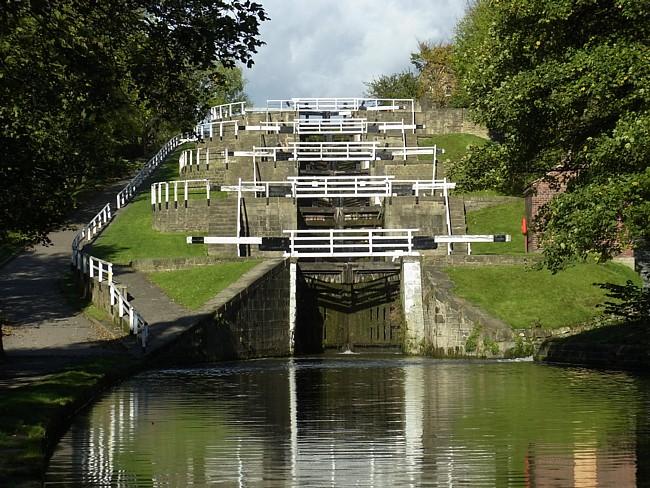
…and the Bingley Five Rise Locks on the Leeds and Liverpool Canal in Bingley, England, said to have been completed in 1774. The Algiers Circle Alignment I am currently following will pass directly through Leeds, England, in the latter part of it.
The circle alignment passes through the town of Richwood, on its way to Monroe, Louisiana, the ancient Imperial Seat of the Washitaw Empire, in an area known as Washitaw Proper.

The recently deceased Empress of the Washitaw, Verdiacee Washitaw Turner Goston El Bey signifies many things, but for this example she was the mayor of Richwood, Louisiana, from 1975 – 1976.

Empress Verdiacee passed away in 2014, and her granddaughter Wendy Farica Washitaw succeeded her as the Washitaw Empress.
It is important to note that the Watson Brake Lunar Mounds are in the vicinity of Richwood, Watson Brake is an archeological site in Ouachita Parish, Louisiana, dated to 5,400 years ago, and is the oldest earthwork mound complex in North America, acknowledged to be older than the Egyptian Pyramids and Stonehenge in England. It is located on private land, so is not available for public viewing.

Stonehenge, which has an earthwork very similar to Watson Brake around its perimeter, according to what we are told, dates from starting at 3,100 BC, about 5,100 years ago.

Monroe is the parish seat of the Ouachita (pronounced Washitaw) Parish.

Monroe and West Monroe, which together are called the Twin Cities of northeast Louisiana, are situated on either side of the snaky, S-shaped Ouachita River.

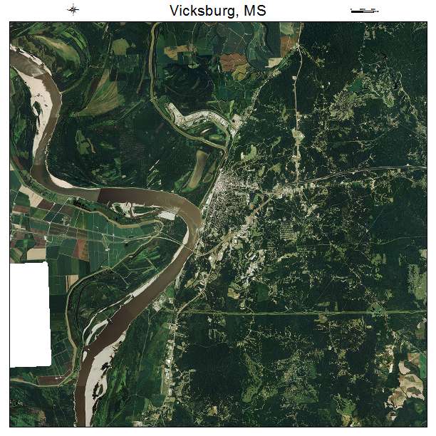
Just like the snaky, s-shaped riverbends of the Mississippi River at Vicksburg, Mississippi…
…and Cape Girardeau, Missouri.

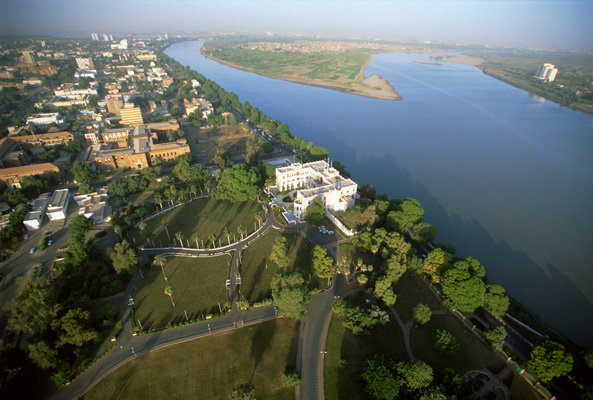
The Nile River has snaky, S-shaped riverbends as well, like at Juba in South Sudan…

…and here is a photo of the Nile in the Asyut Valley of Upper Egypt.

And here is a comparison of where the Missouri and Mississippi Rivers meet near St. Louis, MIssouri…
…with the place where the White Nile and Blue Nile meet at Khartoum, the capital of Sudan.
Back to Monroe, Louisiana. Monroe is the Imperial Seat of the Ancient Washitaw Empire, and this part of Louisiana is called Washitaw Proper. This is the Washitaw flag.

Thirty-eight miles northeast of Monroe, near the town of Epps, Louisiana, is Poverty Point.

It is said to have become known as Poverty Point because the farming was terrible here.

Its name is actually Awulmeka, and was an ancient sacred city of the Washitaw Mu’urs.

The story that we are told about all the mound sites is that indians wearing loincloths were responsible for building the perfectly geometrically- and astronomically-aligned mounds and earthworks, one basketful of dirt at a time. This is not the truth, and does not hold up with any scrutiny whatsoever.

These are the kinds of artifacts on display at Poverty Point as being representative of what was found here. While perhaps they were found here, I don’t think they were representative of the highly advanced and sophisticated ancient civilization that lived here.

The artifacts on display at Spiro Mounds in Oklahoma, like this one here, would be more representative of what was found at Poverty Point.

Muurish-American Master Adepts and Teachers in the present day are wisdom-keepers of ancient sacred Kemetic Mysteries and Knowledge about all Creation. They are living practitioners of Egyptian Yoga and Medu Neter, the language of the Egyptian Hieroglyphs.

In this spirit, I am going to the next place on the alignment in an area west of Little Rock, Arkansas, which has special sites that aren’t brought forward into public awareness, and represent how sacred ancient sites are deliberately covered-up.
The first place is Pinnacle Mountain, which is an Arkansas State Park.
I had first heard of Pinnacle Mountain when I learned there was an Earthkeeper Conference there in 2012.
I didn’t think much of the name Pinnacle Mountain until several years later, in 2015, when finding this image on-line. This was the beginning of my “looking” and then “finding” out more and more. It really got my attention!!!

So I had to go there! It was about a 3 – 4 hour drive from where I was living at the time, and I went twice with friends. There is only place you can get this clear view of Pinnacle Mountain as a pyramid, which is from the Education Pond at the park.
And this next view of Pinnacle Mountain and two more pyramids is only obtainable from the Visitor Center Observation Deck on a relatively clear day.

Otherwise, access to all other views is completely cut off by private property and fences, and these are certainly not advertised as pyramids.
The alignment is also close to Mount Magazine, located outside of Paris, Arkansas. Mount Magazine is in the Ouachita Mountains of western Arkansas and eastern Oklahoma. The memory of the people is in the name. This is called Cameron’s Bluff at Mount Magazine.

I visited Mount Magazine several times, and this is where I started waking up to seeing what was really in the environment around me. As soon as I took to the turn-off for the road that skirts the bluff, I started seeing a wall.

It is such an ancient wall that there is some element of doubt.

But there are some places you can really tell it is a built structure.

The next place on the circle alignment is Springfield, the third largest city in Missouri, and the seat of Greene County.

This is the Pythian Castle in Springfield, said to have been built in 1913 as an orphanage, and similar in appearance to the Old Louisiana State House in Baton Rouge. It was said to have been built by the Knights of Pythias, a secret society founded in Washington, D.C in February of 1864, and was the first fraternal order to receive a charter by an Act of Congress. It is interesting to note that the Civil War didn’t end until 1865. For what purpose would Congress charter a fraternal secret society in wartime?

This is the Abou Ben Adhem Shrine Mosque in Springfield, said to have been built in 1923. Again, we just assume the people who said they built these places did so because we have no other information to go by.

Another example of this practice is at Ha Ha Tonka State Park in Camdenton, Missouri, north of Springfield on the alignment. The castle here was said to have been started by a Kansas businessman in 1905, finished by his sons in the 1920s before the stock market crash, and destroyed by fire in 1942.


Like the Yucatan Peninsula, Ha Ha Tonka has sinkholes, and caves, and even a huge so-called “natural” bridge…

…and Missouri’s twelfth largest spring.

I am going to pick up the alignment in the next post in Des Moines, Iowa.

Michelle, I was intrigued by your grid work remarks on the Unknown Light Warrior show. I have been working on anchoring the crystalline grids but am a novice.
I am also working on transmuting toplets. I was wondering if you could get in touch with me concerning these.
Thank you for your consideration.
Janehoffmanrn@yahoo.com
LikeLike
And this is why the blog post is so awesome, got to read it in the walk in clinic while waiting on the boy to get some stitches out(nothing major, just a dumb kid injury) and it’s like winning because there’s no video for this yet! Great information in this one Michelle! In all of them really!
LikeLike
Thanks! I just uploaded the video a few minutes ago.
I am really enjoying your work ~ it seems like there are synergies between what you are doing and what I am doing!
LikeLike
I would like to know what Andrew is doing and if there is a way I can read or see it. Michelle you have been leading me on a journey of enlightenment. I am loving it. Keep up the great work. I will try to send you links to anything that may be helpful.
LikeLike
This is his YouTube Channel ~Baltimore Fats/Mud City:
https://www.youtube.com/user/ubada
A mutual sub on YouTube connected him to my work, then I started following his work. His work will be easier to follow if you start from the beginning because his episodes tend to build on each other. I am seeing on a global level what he’s finding in his research on Baltimore.
His work was my first introduction to the Mud Flood community on YouTube. The Mud Flood makes a whole lot of sense to me based on what I am seeing. We are all looking at the same buildings!
This is a good introductory video on the Mud Flood if you are not familiar with it:
I also really like the JonLevi Channel. His work is amazing too! Not necessary to follow his work sequentially. Here’s a good one of his about the Chicago’s World Fair:
Thanks so much for all of your feedback and interest! I am enjoying what I am doing, and am going deeper with the information all the time.
LikeLiked by 1 person
Awesome work!
LikeLike
Thank you! I convert all my blog posts into videos for YouTube and Bitchute. I want to get this information back out into the collective awareness as quickly and effectively as possible. I was not born knowing this, but my life’s journey has been deeply connected to uncovering this information and putting it all together. I am far from being done with all that have to share. Here is the link to my YouTube channel:
https://www.youtube.com/channel/UCadBL43irIsBzL6-tIunFtA/videos
LikeLike